Fortified Cities from Le Quesnoy

This route was brought to you by:
RouteXpert Jan Koelstra - Senior Rx
Last edit: 27-05-2025
 Route Summary
 In addition to admiring these fortifications, attention is also paid to the fortified towns and villages themselves as well as the general sights. The most important military fortifications of both world wars are also mentioned along the route.
The route is rated with five stars because of the alternation between the vastness of the landscape, the pleasant, sometimes surprising roads on the one hand and the ingenious constructions of the fortified towns and forts on the other.
 Share this route


Animation

Verdict


Duration
8h 29m

Mode of travel
Car or motorcycle

Distance
181.20 km

Countries


 RouteXpert Review
 The claims of Louis XIV of France on Flanders resulted in five French occupations between 1646 and 1706 and the construction of fortifications and citadels on both sides. During the wars of Louis XIV of France it became clear that the Spanish Empire was no longer able to defend the Southern Netherlands. If the Southern Netherlands were lost, France would become a threat to the Republic and to the balance of power in Europe.
You will start this tour in the now quiet, historic town of Cambrai, where some remains of fortifications are still visible. It is one of twelve fortresses built by Vauban in France and is an important part of the history of military architecture. The fortress of Cambrai, with its central gun tower and horseshoe-shaped defensive wall, is an example of Vauban's innovative approach to defence. These fortifications, which are part of the UNESCO World Heritage List, bear witness to Vauban's ingenious techniques and his important contribution to the development of military architecture.
In addition, the city is known for its prestigious religious buildings and stately mansions. A visit to the Chapelle du Grand Séminaire, known for its baroque facade and the Cathédrale Notre-Dame, with exceptional works of art and beautiful stained glass windows, should not be missed during your visit to this city! When leaving the city towards the fortified town of Le Quesnoy, you will pass a petrol station.
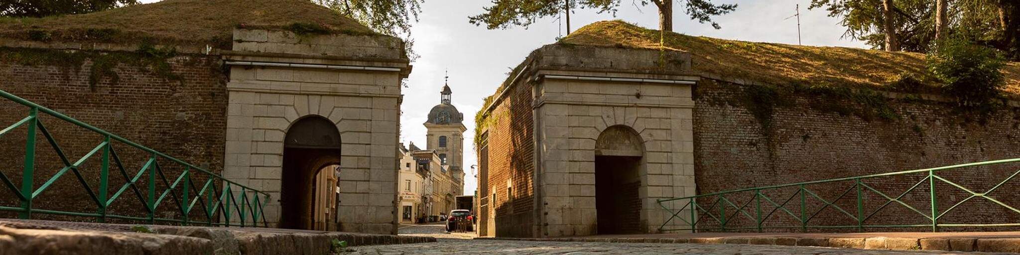
The Dutch have their Naarden, the French their Quesnoy. In fact, the fortifications, which were built here in the 17th century by Vauban, are exceptionally well preserved. Le Quesnoy lies between the open fields of the Cambrésis and the hedgerow landscape of the Thiérache. Nowhere in France can you better see the response defenders had to the developments of 17th century artillery. Moats, pointed defenses placed in the water and bastions with the star-shaped Vauban pattern, in Le Quesnoy everything is still as Vauban developed the fortified town. To enjoy this cool construction, a walk over the ramparts is recommended and then conclude with a well-deserved coffee.
The next fortified town is in Maubeuge, near the Belgian border. It was not until 1678 that the French managed to take Maubeuge. Louis XIV immediately converted this outpost of his empire into a fortified centre. Unfortunately, much of the old urban beauty was lost during the Second World War. The fortifications were not spared either. What remains lies on some 30 hectares on the left bank of the Sambre. The Porte de Mons gateway is the only authentic passage, complete with drawbridge, restored in the late seventies. The gunpowder room that Vauban had built now houses the local library and an art school.
On the other side of the current border with Belgium lies the fortified town of Binche. The fortifications in Binche, part of a larger network of fortifications, are a testament to Vauban's expertise in designing defensive structures, including moats, walls, bastions and forts, to protect towns from enemy attack. The medieval city wall, built between the 12th and 14th centuries, is over two kilometres long and is the best preserved medieval wall in Belgium. Near the city wall is the city park of Binche, where you can find the ruins of the Palace of Mary of Hungary, the sister of Charles V. The palace must have been exceptionally beautiful, as it was called by some "the eighth wonder of the world". Unfortunately, it did not last long. After only 9 years, the troops of the King of France set fire to the palace.
The statue of Gilles marks the entrance to the International Carnival and Mask Museum. The museum is open all year round and is housed in the old Augustinian College, which dates back to the 18th century. After your visit to the museum, head towards the city centre. Walk to the Grand Place of Binche with the town hall of Binche (in Gothic style) and its belfry in the middle.
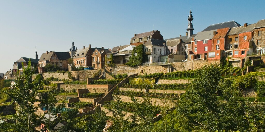
Thuin is divided into 'la Ville-Haute' and 'la Ville-Basse': the upper town and the lower town. The main sights are the city walls (with Notger Tower) and the belfry from the 17th and 18th centuries, formerly the tower of the collegiate church of St. Theodard.
The "hanging gardens" against the southern ramparts are also famous. There are about 200 walled gardens, laid out in terraces, with paved paths running between them. The hanging gardens were built in the Middle Ages to protect the rocky slopes from erosion and to provide space for vegetable gardens. The sunlight and the heat stored in the sandstone walls ensure lush growth. Since 2001, a small vineyard has been planted in the hanging gardens, from which the sweet red Clos des Zouaves is made.
The fortifications of Charleroi, once a crucial part of the defense of the Spanish Netherlands, were built in the late 17th century and the first half of the 18th century. The aim was to repel the threat of the French king Louis XIV, who laid claim to the Spanish Netherlands. The fortifications were expanded by the French under the direction of Vauban, the famous military architect.
Charleroi is known as one of the ugliest cities in the world. Although the ugliness of Charleroi dominates, the city also has a lot of nice things to offer, such as the beautiful old city hall or the Belfry on the same square.
On the way to Givet, the end point of this route, you will pass the chateau d'Acoz. The originally quadrangular fortified castle was the property of the Abbey of Floreffe in the 12th century. Later, the domain came into the hands of various families: Marotte, d'Udekem and Pirmez. In 2001, Tony Cammaert, a well-known antique dealer from Brussels and specialist in Japanese art, acquired the castle. He started a thorough restoration, and today all kinds of activities and events are organised there.
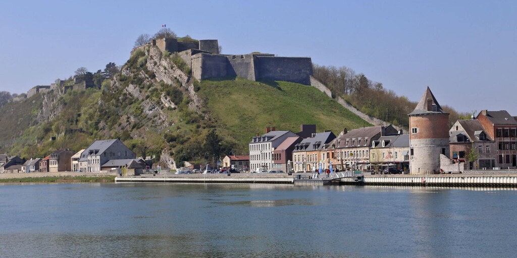
Due to its cross-border location, the city of Givet is rich in remnants from the past. This city was fortified under Emperor Charles V with the construction of the fort of Charlemont, a sensational stronghold, later the inevitable Vauban, architect of King Louis XIV, came to Givet - the city was French in the meantime - to build a gigantic defense system around the city. Louis XIV had the ambition to keep the Meuse valley within the kingdom of France. Churches, narrow streets, towers, fortified gates and many other monuments show the important role that this Meuse city played many centuries ago. For the rider of this tour, however, the inner man is important. Plenty of opportunities on the Meuse!
 Links
Links  Usage
Usage Want to download this route?
You can download the route for free without MyRoute-app account. To do so, open the route and click 'save as'. Want to edit this route?
No problem, start by opening the route. Follow the tutorial and create your personal MyRoute-app account. After registration, your trial starts automatically.  Disclaimer
Use of this GPS route is at your own expense and risk. The route has been carefully composed and checked by a MyRoute-app accredited RouteXpert for use on TomTom, Garmin and MyRoute-app Navigation.
Changes may nevertheless have occurred due to changed circumstances, road diversions or seasonal closures. We therefore recommend checking each route before use.
Preferably use the route track in your navigation system. More information about the use of MyRoute-app can be found on the website under 'Community' or 'Academy'.

Grand Est
About this region
Grand Est (French: [ɡʁɑ̃t‿ɛst] (listen); Alsatian: Grossa Oschta; Moselle Franconian/Luxembourgish: Grouss Osten;
Rhine Franconian: Groß Oschte; German: Großer Osten [ˈɡʁoːsɐ ˈʔɔstn̩]; English: "Greater East") is an administrative region in Northeastern France. It superseded three former administrative regions, Alsace, Champagne-Ardenne and Lorraine, on 1 January 2016 under the provisional name of Alsace-Champagne-Ardenne-Lorraine (pronounced [alzas ʃɑ̃paɲ aʁdɛn lɔʁɛn]; ACAL or, less commonly, ALCA), as a result of territorial reform which had been passed by the French Parliament in 2014.The region sits astride three water basins (Seine, Meuse and Rhine), spanning an area of 57,433 km2 (22,175 sq mi), the fifth largest in France; it includes two mountain ranges (Vosges and Ardennes). It shares borders with Belgium, Luxembourg, Germany and Switzerland. As of 2017, it had a population of 5,549,586 inhabitants. The prefecture and largest city, by far, is Strasbourg.
The East of France has a rich and diverse culture, being situated at a crossroads between the Latin and Germanic worlds. This history is reflected in the variety of languages spoken there (Alsatian, Champenois, and Lorraine Franconian). Most of today's Grand Est region was considered "Eastern" as early as the 8th century, when it constituted the southern part of the Francian territory of Austrasia. The city of Reims (in Champagne), where Frankish king Clovis I had been baptized in 496 AD, would later play a prominent ceremonial role in French monarchical history as the traditional site of the coronation of the kings of France. The Champagne fairs played a significant role in the economy of medieval Europe as well. Alsace and Lorraine thrived in the sphere of influence of the Holy Roman Empire for most of the Middle Ages and Renaissance, and subject to competing claims by France and German over the centuries.
The region has distinctive traditions such as the celebration of Saint Nicholas Day, Christmas markets, or traditions involving the Easter hare in Alsace and Lorraine. Alsace-Moselle are furthermore subject to local law for historical reasons. With a long industrial history and strong agriculture and tourism (arts, gastronomy, sightseeing), the East of France is one of the top economic producing regions in the country.
Read more on Wikipedia
Rhine Franconian: Groß Oschte; German: Großer Osten [ˈɡʁoːsɐ ˈʔɔstn̩]; English: "Greater East") is an administrative region in Northeastern France. It superseded three former administrative regions, Alsace, Champagne-Ardenne and Lorraine, on 1 January 2016 under the provisional name of Alsace-Champagne-Ardenne-Lorraine (pronounced [alzas ʃɑ̃paɲ aʁdɛn lɔʁɛn]; ACAL or, less commonly, ALCA), as a result of territorial reform which had been passed by the French Parliament in 2014.The region sits astride three water basins (Seine, Meuse and Rhine), spanning an area of 57,433 km2 (22,175 sq mi), the fifth largest in France; it includes two mountain ranges (Vosges and Ardennes). It shares borders with Belgium, Luxembourg, Germany and Switzerland. As of 2017, it had a population of 5,549,586 inhabitants. The prefecture and largest city, by far, is Strasbourg.
The East of France has a rich and diverse culture, being situated at a crossroads between the Latin and Germanic worlds. This history is reflected in the variety of languages spoken there (Alsatian, Champenois, and Lorraine Franconian). Most of today's Grand Est region was considered "Eastern" as early as the 8th century, when it constituted the southern part of the Francian territory of Austrasia. The city of Reims (in Champagne), where Frankish king Clovis I had been baptized in 496 AD, would later play a prominent ceremonial role in French monarchical history as the traditional site of the coronation of the kings of France. The Champagne fairs played a significant role in the economy of medieval Europe as well. Alsace and Lorraine thrived in the sphere of influence of the Holy Roman Empire for most of the Middle Ages and Renaissance, and subject to competing claims by France and German over the centuries.
The region has distinctive traditions such as the celebration of Saint Nicholas Day, Christmas markets, or traditions involving the Easter hare in Alsace and Lorraine. Alsace-Moselle are furthermore subject to local law for historical reasons. With a long industrial history and strong agriculture and tourism (arts, gastronomy, sightseeing), the East of France is one of the top economic producing regions in the country.
View region
 Statistics
  84
84Amount of RX reviews (Grand Est)
 42695
42695Amount of visitors (Grand Est)
 14338
14338Amount of downloads (Grand Est)
 Route Collections in this region
 25 Magnificent trails in France
This MRA route collection contains 25 beautiful motorcycle routes in different parts of France, such as the Ardennes, the Alsace, Vercors, the Drôme, the Ardèche, Cote d'Azure, Gorges du Verdon, the Ariège, the Dordogne and Brittany.
The routes have been carefully created by Bert Loorbach, who is an enthusiastic motorcyclist himself. He lived in France for a year and a half, during which time he devoted himself to mapping the unknown and beautiful back roads of France especially for motorcyclists.
The routes are bundled in the Motortourgids France part 1 of Kosmos publishing house and now also available in MyRouteApp.
I have taken over the routes in MRA and sometimes adjusted them slightly to make them even more interesting for the motorcyclist.
View Route Collection
11 day trip from the Netherlands
8 countries in 11 days; The Netherlands, Germany, Austria, Italy, Switzerland, France, Luxembourg and Belgium. This route collections consists of 10 routes that I have driven with friends in the summer of 2019.
The start is in Geldermalsen Netherlands, the first 7 days you drive through the Netherlands, Germany, Austria, Italy, Switzerland, France and a piece of Luxembourg with overnight stays in hotels.
The last three days you stay in Barweiler (D) in the Eifel and you drive two beautiful tours through the Eifel, Luxembourg and parts of the Belgian Ardennes.
There is no highway in the routes, only beautiful provincial and country roads, many beautiful passes with beautiful panoramas.
Be sure to check whether the passes are open before you leave.
These are routes for experienced drivers.
View Route Collection