Nederweert Baiersbronn

This route was brought to you by:
RouteXpert Hans van de Ven (Mr.MRA)
Last edit: 29-12-2020
 Route Summary
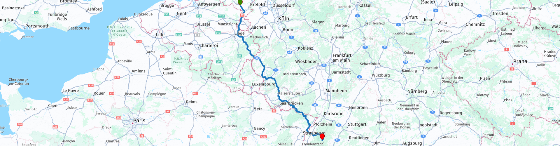
 Route on May 20, 2019 corrected based on the recorded Track.
Starting point: AC Restaurant Nederweert Zuid
End point: Hotel Falken Baiersbronn.
Route made equal for Garmin, TT and MyRoute-app Navigation.
 Share this route


Animation

Verdict


Duration
7h 0m

Mode of travel
Car or motorcycle

Distance
537.12 km

Countries


 RouteXpert Review
 We decided to leave early at 7 AM at AC Restaurant Nederweert Zuid along the A2. We are all there on time, so at 6:45 am we set sail for Baiersbronn.
The 1st part to Bitburg is largely on the highway, after all we have to cover 537 KM today. The journey goes well, little traffic on the road around this time. In Bitburg we refuel and drink a cup of coffee. After coffee it goes a bit inside and then we go back on the highway for 120 km.
The second part is also making good progress, still with little traffic on the road, but unfortunately we discover that not everything is open yet where we want to stop, so you can see that the information on the internet is not always correct either. No worries, we have an emergency ration with us in the top case, so that if necessary we do something about it. We leave the highway behind us to drive in until next Saturday, we start just above the French border in Walshausen.
It is now time to have lunch, we stop in Fischbach bei Dahn at Landhaus Tausendschön. After lunch it continues and we enter the Vosges, this is also a very nice area to drive through, after we have crossed the Rhine, we are back in Germany and we are preparing for the last part, we are getting acquainted with the B500, the Schwarzwaldhochstraße *
* The Schwarzwaldhochstraße is an impressive, wide road that runs through the Black Forest. Another well-known name for this route is also B500. The winding route goes through the nature park and runs from Baden-Baden to Freudenstadt, at heights from 800 meters to a kilometer. The road offers visitors an enchanting view of the Rhine Valley and the Vosges. Not to mention that the beautiful nature certainly invites you to walk, take pictures and enjoy the sights along this route.
After the Schwarzwaldhochstraße we continue on to Baiersbronn, where we fill up a few kilometers in front of the hotel, so that we can set off again tomorrow with a full tank.
Because we have driven this route ourselves, we rate it with 5 stars.
Route details:
rp 1 - Departure point, AC Restaurant Nederweert Zuid
rp 5 - ARAL Bitburg, Tanks and Coffee
rp 22 - P-Walshausen, something from the emergency ration and stretching your legs. (Because planned location was closed)
rp 26 - ed-Tankstelle (if required)
rp 29 - Lunch stop at Landhaus Tausendschön
rp 43 - Tank stop in Baiersbronn
rp 45 - Hotel Falken Baiersbronn


 Links
Links  Usage
Usage Want to download this route?
You can download the route for free without MyRoute-app account. To do so, open the route and click 'save as'. Want to edit this route?
No problem, start by opening the route. Follow the tutorial and create your personal MyRoute-app account. After registration, your trial starts automatically.  Disclaimer
Use of this GPS route is at your own expense and risk. The route has been carefully composed and checked by a MyRoute-app accredited RouteXpert for use on TomTom, Garmin and MyRoute-app Navigation.
Changes may nevertheless have occurred due to changed circumstances, road diversions or seasonal closures. We therefore recommend checking each route before use.
Preferably use the route track in your navigation system. More information about the use of MyRoute-app can be found on the website under 'Community' or 'Academy'.

Belgian Limburg
About this region
Limburg (, Dutch pronunciation: [ˈlɪmbʏr(ə)x] (listen); Dutch: Limburg; Limburgish: Limburg; French: Limbourg) is a province in Belgium. It is the easternmost of the five Dutch-speaking provinces that together form the Region of Flanders, one of the three main political and cultural sub-divisions of modern Belgium.
Limburg is located west of the Meuse (Dutch: Maas), which separates it from the similarly-named Dutch province of Limburg. To the south it also shares a border with the French-speaking province of Liège, with which it also has historical ties. To the north and west are the old territories of the Duchy of Brabant. Today these are the Flemish provinces of Flemish Brabant and Antwerp to the west, and the Dutch province of North Brabant to the north.
The province of Limburg has an area of 2,427 km2 (937 sq mi) which comprises three arrondissements (arrondissementen in Dutch) containing 44 municipalities. Among these municipalities are the current capital Hasselt, Sint-Truiden, Genk, and Tongeren, the only Roman city in the province, and regarded as the oldest city of Belgium. As of January 2019, Limburg has a population of 874,048.The municipality of Voeren is geographically detached from Limburg and the rest of Flanders, with the Netherlands to the north and the Walloon province of Liège to the south. This municipality was established by the municipal reform of 1977 and on 1 January 2008 with its six villages had a total population of 4,207. Its total area is 50.63 km2 (19.55 sq mi).
Read more on Wikipedia
Limburg is located west of the Meuse (Dutch: Maas), which separates it from the similarly-named Dutch province of Limburg. To the south it also shares a border with the French-speaking province of Liège, with which it also has historical ties. To the north and west are the old territories of the Duchy of Brabant. Today these are the Flemish provinces of Flemish Brabant and Antwerp to the west, and the Dutch province of North Brabant to the north.
The province of Limburg has an area of 2,427 km2 (937 sq mi) which comprises three arrondissements (arrondissementen in Dutch) containing 44 municipalities. Among these municipalities are the current capital Hasselt, Sint-Truiden, Genk, and Tongeren, the only Roman city in the province, and regarded as the oldest city of Belgium. As of January 2019, Limburg has a population of 874,048.The municipality of Voeren is geographically detached from Limburg and the rest of Flanders, with the Netherlands to the north and the Walloon province of Liège to the south. This municipality was established by the municipal reform of 1977 and on 1 January 2008 with its six villages had a total population of 4,207. Its total area is 50.63 km2 (19.55 sq mi).
View region
 Statistics
  66
66Amount of RX reviews (Belgian Limburg)
 49526
49526Amount of visitors (Belgian Limburg)
 17577
17577Amount of downloads (Belgian Limburg)
 Route Collections in this region
 The 10 most beautiful car and motorcycle routes in North Brabant
Brabant, Brabant conviviality, bon vivants and who does not know the song by Guus Meeuwis about Brabant? "And then I think of Brabant, because there is still light burning there" and that is true, because the City of Light is in Brabant, in Eindhoven that is, but Eindhoven is also known as the match city of the Netherlands. The annual light festival (GLOW) in Eindhoven shows breathtaking lighting techniques, something you must see once.
But not only light, matches and Brabant cosiness in Brabant, but also a very beautiful province to tour by car or motorcycle and enjoy all the beauty that the province of Brabant has to offer. For this, the MyRoute app RouteXpert has put together a Top 10 of Car and Motorcycle routes for you.
All routes in this collection have been checked and made equal for TomTom, Garmin and MyRoute-app Navigation by a MyRoute-app RouteXpert.
If you think, I have a very nice route that should certainly not be missing from this collection, send it to:
email: routeexpert@myrouteapp.com
Subject: New Route for the Top 10 collection Province of Brabant composed by Hans van de Ven.
The route will then be reviewed and then added to the Top 10.
To make the Top 10 also the Top 10, 1 route will have to disappear from the Top 10, you can indicate this when submitting the new route.
Have fun with this collection and while driving one of these routes. Enjoy all the beauty that the Netherlands and in particular the province of Brabant has to offer. Click on “View route” to read the review of the chosen route.
I would like to hear your findings about the route(s).
View Route Collection
The 10 most beautiful car and motorcycle routes in Limburg
Limburg, who thinks of Limburg, thinks of flan, coal mines, marl and the hill country. The coal mines have been closed for almost 40 years, the last load of coal was brought up from the Oranje-Nassau coal mine in Heerlen on 31 December and, as they say, South Limburg was transformed from Black to Green and unfortunately there is still little left. view of this period.
But not only pie, marl and coal in Limburg, but also a very beautiful province to tour by car or motorcycle and enjoy all the beauty that the province of Limburg has to offer. For this, the MyRoute app RouteXpert has put together a Top 10 of Car and Motorcycle routes for you.
All routes in this collection have been checked and made equal for TomTom, Garmin and MyRoute-app Navigation by a MyRoute-app RouteXpert.
If you think, I have a very nice route that should certainly not be missing from this collection, send it to:
email: routeexpert@myrouteapp.com
Subject: New Route for the Top 10 collection Province of Limburg composed by Hans van de Ven.
The route will then be reviewed and then added to the Top 10.
To make the Top 10 also the Top 10, 1 route will have to disappear from the Top 10, you can indicate this when submitting the new route.
Have fun with this collection and while driving one of these routes. Enjoy all the beauty that the Netherlands and in particular the province of Limburg has to offer. Click on “View route” to read the review of the chosen route.
I would like to hear your findings about the route(s).
View Route Collection