TTT 1995 07 van Geulle naar Thorn

This route was brought to you by:
RouteXpert Hans van de Ven (Mr.MRA)
Last edit: 23-05-2020
 Route Summary
 The 173 ANWB Promoter TankTasTochten (TTT) were scanned by Henry ten Dam and signed by Leon Stolk in Mapsource and later placed as a Track in a .gpx file. These have been made available with the approval of ANWB Promotor via the website of MrGPS so that everyone can enjoy it. The 1st TTT is from 1992, so the route may be slightly different from the original.
I checked all route points and placed them neatly on the road. Also, if necessary, I have put the start point and end point of the route a bit further apart to avoid navigating directly to the end point and I have added the POI files from the start and end point just like a possible stopping point.
Finally, I created the route for TomTom, Garmin and MyRoute-app Navigation users.
With thanks to Henry, Leon, MrGPS and Promoter.
 Share this route


Animation

Verdict


Duration
3h 38m

Mode of travel
Car or motorcycle

Distance
144.95 km

Countries


 RouteXpert Review
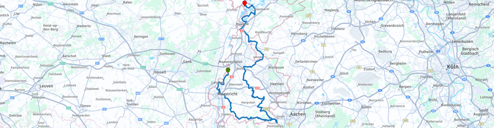
 So we continue where the previous TTT stopped, in Geulle. This route is mostly about beautiful roads. From Geulle you go to Maastricht, where you dive into the Heuvelland in the direction of Vaals. It is always here to enjoy, but on Sundays it gets busier and busier, so if possible you can drive this route on a weekday. After Vaals you drive north, around Sittard, the loop at Roosteren to arrive at Thorn via Maasbracht and Wessem, Thorn - the white town in the middle of Limburg.
History of Thorn
The white town of Thorn, which is visited by many tourists, has a rich history, dating back to the end of the 10th century.
Over time, a miniature principality developed under the leadership of an abbess and noble monastic ladies. The state had its own jurisdiction and minted its own currency.
In 1794 this came to an end with the arrival of the French. Then Thorn got his distinctive white color. After the noble ladies fled, the French charged a tax based on the size of the windows. The poor population, often living in large buildings, formerly belonging to rich people, could not afford it. To limit the height of the load, the windows were closed. With the aim of hiding the construction traces ("scars of poverty"), the houses were chalked white.
More about Thorn: https://vvvmiddenlimburg.nl/nl/thorn-witte-stadje-midden-limburg
Because I have not driven this route (yet) myself, this route gets 3 stars.
Route details:
rp 19 - Possibly stop at the "Drielandenpunt". Pay attention to your motorcycle, unfortunately it happens regularly that an engine is stolen, even if it is locked, so always put it in sight.


 Usage
Usage Want to download this route?
You can download the route for free without MyRoute-app account. To do so, open the route and click 'save as'. Want to edit this route?
No problem, start by opening the route. Follow the tutorial and create your personal MyRoute-app account. After registration, your trial starts automatically.  Disclaimer
Use of this GPS route is at your own expense and risk. The route has been carefully composed and checked by a MyRoute-app accredited RouteXpert for use on TomTom, Garmin and MyRoute-app Navigation.
Changes may nevertheless have occurred due to changed circumstances, road diversions or seasonal closures. We therefore recommend checking each route before use.
Preferably use the route track in your navigation system. More information about the use of MyRoute-app can be found on the website under 'Community' or 'Academy'.