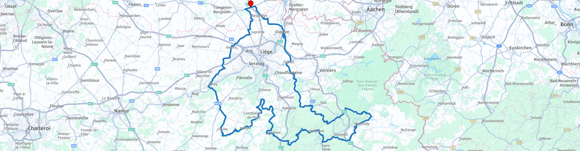
Waterfall tour out of Tongeren via Coo and Reinhardstein

This route was brought to you by:
RouteXpert Guy Heyns - Sr RouteXpert
Last edit: 10-12-2024
 Route Summary
 Please do expect an exciting trip that will take you the whole day to complete if you want to take a stop at least at both waterfalls.
Please also do take into account that the roads are not the easiest ones. If a newbie is with you, then do pay attention to his / her fatigue and take an extra resting point if needed.
Then all will go well and all of you will enjoy this fabulous day trip that takes you across nice places like the Ourthe, the Amblève, Coo, Reinhardstein & Francorchamps, while driving through nice forests & woods on a rollercoaster with 600 meter height differences.
 Share this route


Animation

Verdict


Duration
6h 12m

Mode of travel
Car or motorcycle

Distance
279.26 km

Countries

 RouteXpert Review
 The departure of this tour is near Tongeren, the oldest city in Belgium. The main market there is decorated with a statue of Ambiorix & the Gallo-Roman museum, which enjoys international fame. More information about Tongeren can be found in the route links, but you can count on it that the city of Tongeren itself is more than worth a visit if you are staying in the area.
Shortly after departure at the Pauze, the place of departure and arrival, you will come across a petrol station at route point 2, after which we leave the main road. Almost immediately we dive into the Walloon landscape. Moreover, the speed limit in Wallonia is 90 km / h outside the city and village centers, so motorcycle fun is guaranteed.
The tour actually takes you in a wide circle around Liège. One of the points of contact with this very large city is the former military airport that is now also commercially exploited. (rp 7).
At route point 10 you cross the Maas, a very important river for both Belgium and the Netherlands and also the gate to the motor playground that this route actually is.
From route point 15 it is also best to take a look along the road. You will meet wonderful rivers such as the Ourthe and the Amblève and both will accompany you on this interesting trip. At route point 16 you can take a break along the banks of the Ourthe in 'Le Dilemme' or 'Le Bellevue' ... it is difficult to choose which of the two offers you the best view! (Do you have it?)
After route point 21 we leave the Amblève for a while to concentrate our route by route on the wonderful roads, but you will meet the peak of the Amblève just after rp 28 where you can visit the waterfalls of Coo. Please note, very touristic point as the waterfalls of Coo are the most famous in Belgium. Most people also think it is the highest waterfall in Belgium, but they are definitely mistaken there. The highest waterfall is that of Reinhardstein, which you will pass later on the route.
The Waterfalls of Coo were actually created artificially by the monks of Stavelot Abbey. To provide their water mill with sufficient water, a meander of the Amblève was re-laid and the excess water flowed away over the rocks. This created the waterfalls of Coo. You will find many establishments to take a short break if you wish. If time and energy permit, you can also take the chairlift for a trip to the watchtower, which offers a wonderful view of the surrounding region.
Another, much less known, but nevertheless the highest waterfall in Belgium, the Reinhardstein waterfall, is located 30 kilometers further on the route at route point 32. This 60 meter high waterfall is close to the castle of the same name, which is also open to visitors. and where the Middle Ages revive in words and images. Perhaps you will have to make a choice on this trip to visit one or the other. After all, both are worth it, although the tourist lover will feel more at home in the very touristic Coo region. And if you want a break in between, Malmédy (rp31) is the perfect place for this. Plenty of parking and a great place to stay on the marketplace, which is full of lovely terraces.
Fortunately, the cornering is far from over and the world's most famous cornering is still to come: the Spa-Francorchamps circuit. You almost touch it at route point 36. If you wish, you can take a short stop and visit the world-famous circuit.
But even after this the feast continues. Wonderfully winding asphalt keeps sliding under your wheels, even after you pass the Maas and the Albert Canal, two lifelines of Belgium, just after route point 47.
At route point 50 you will then re-enter Flanders and very quickly reach the end of the route.
The route is absolutely classy material. Not only the road quality, but also the variety, the many attractions and the technicality of the route make the five-star rating of this route absolutely just. However, beware of novice riders. Caution is advised and a fit of overconfidence is better left at home. Both the technicality and the length of the route will demand a lot from every rider. Even more experienced riders will have to admit some fatigue, so a beginner will certainly hit their limits here. No problem if this is acknowledged in time and taken into account. And if that is the case, then that smile in dreamland the night after is really deserved.


 Links
Links  Usage
Usage Want to download this route?
You can download the route for free without MyRoute-app account. To do so, open the route and click 'save as'. Want to edit this route?
No problem, start by opening the route. Follow the tutorial and create your personal MyRoute-app account. After registration, your trial starts automatically.  Disclaimer
Use of this GPS route is at your own expense and risk. The route has been carefully composed and checked by a MyRoute-app accredited RouteXpert for use on TomTom, Garmin and MyRoute-app Navigation.
Changes may nevertheless have occurred due to changed circumstances, road diversions or seasonal closures. We therefore recommend checking each route before use.
Preferably use the route track in your navigation system. More information about the use of MyRoute-app can be found on the website under 'Community' or 'Academy'.

Wallonia
About this region
The Walloon Region (French: Région wallonne [ʁeʒjɔ̃ walɔn]; German: Wallonische Region; Dutch: Waals gewest), usually simply referred to as Wallonia (; French: Wallonie [walɔni]; Walloon: Waloneye; German: Wallonien [vaˈloːni̯ən] (listen) or Wallonie [valoˈniː]; Dutch: Wallonië [ʋɑˈloːnijə] (listen)), is one of the three Regions of Belgium—alongside the Flemish Region and the Brussels-Capital Region.Covering the southern portion of the country, Wallonia is primarily French-speaking, and accounts for 55% of Belgium's territory, but only a third of its population. The Walloon Region was not merged with the French Community of Belgium, which is the political entity responsible for matters related mainly to culture and education, because the French Community of Belgium encompasses both Wallonia and the bilingual Brussels-Capital Region.
There is a German-speaking minority in eastern Wallonia, resulting from the annexation of three cantons previously part of the German Empire at the conclusion of World War I. This community represents less than 1% of the Belgian population. It forms the German-speaking Community of Belgium, which has its own government and parliament for culture-related issues.
During the industrial revolution, Wallonia was second only to the United Kingdom in industrialization, capitalizing on its extensive deposits of coal and iron. This brought the region wealth, and from the beginning of the 19th to the middle of the 20th century, Wallonia was the more prosperous half of Belgium. Since World War II, the importance of heavy industry has greatly diminished, and the Flemish Region has exceeded Wallonia in wealth as Wallonia has declined economically. Wallonia now suffers from high unemployment and has a significantly lower GDP per capita than Flanders. The economic inequalities and linguistic divide between the two are major sources of political conflicts in Belgium and a major factor in Flemish separatism.
The capital of Wallonia is Namur, and the most populous city is Charleroi. Most of Wallonia's major cities and two-thirds of its population lie along the east-west aligned Sambre and Meuse valley, the former industrial backbone of Belgium. To the north of this valley, Wallonia lies on the Central Belgian Plateau, which, like Flanders, is a relatively flat and agriculturally fertile area. The south and southeast of Wallonia is made up of the Ardennes, an expanse of forested highland that is less densely populated.
Wallonia borders Flanders and the Netherlands (the province of Limburg) in the north, France (Grand Est and Hauts-de-France) to the south and west, and Germany (North Rhine-Westphalia and Rhineland-Palatinate) and Luxembourg (Capellen, Clervaux, Esch-sur-Alzette, Redange and Wiltz) to the east. Wallonia has been a member of the Organisation Internationale de la Francophonie since 1980.
Read more on Wikipedia
There is a German-speaking minority in eastern Wallonia, resulting from the annexation of three cantons previously part of the German Empire at the conclusion of World War I. This community represents less than 1% of the Belgian population. It forms the German-speaking Community of Belgium, which has its own government and parliament for culture-related issues.
During the industrial revolution, Wallonia was second only to the United Kingdom in industrialization, capitalizing on its extensive deposits of coal and iron. This brought the region wealth, and from the beginning of the 19th to the middle of the 20th century, Wallonia was the more prosperous half of Belgium. Since World War II, the importance of heavy industry has greatly diminished, and the Flemish Region has exceeded Wallonia in wealth as Wallonia has declined economically. Wallonia now suffers from high unemployment and has a significantly lower GDP per capita than Flanders. The economic inequalities and linguistic divide between the two are major sources of political conflicts in Belgium and a major factor in Flemish separatism.
The capital of Wallonia is Namur, and the most populous city is Charleroi. Most of Wallonia's major cities and two-thirds of its population lie along the east-west aligned Sambre and Meuse valley, the former industrial backbone of Belgium. To the north of this valley, Wallonia lies on the Central Belgian Plateau, which, like Flanders, is a relatively flat and agriculturally fertile area. The south and southeast of Wallonia is made up of the Ardennes, an expanse of forested highland that is less densely populated.
Wallonia borders Flanders and the Netherlands (the province of Limburg) in the north, France (Grand Est and Hauts-de-France) to the south and west, and Germany (North Rhine-Westphalia and Rhineland-Palatinate) and Luxembourg (Capellen, Clervaux, Esch-sur-Alzette, Redange and Wiltz) to the east. Wallonia has been a member of the Organisation Internationale de la Francophonie since 1980.
View region
 Statistics
  103
103Amount of RX reviews (Wallonia)
 29734
29734Amount of visitors (Wallonia)
 24598
24598Amount of downloads (Wallonia)
 Route Collections in this region
 The 10 most beautiful car and motorcycle routes in Limburg
Limburg, who thinks of Limburg, thinks of flan, coal mines, marl and the hill country. The coal mines have been closed for almost 40 years, the last load of coal was brought up from the Oranje-Nassau coal mine in Heerlen on 31 December and, as they say, South Limburg was transformed from Black to Green and unfortunately there is still little left. view of this period.
But not only pie, marl and coal in Limburg, but also a very beautiful province to tour by car or motorcycle and enjoy all the beauty that the province of Limburg has to offer. For this, the MyRoute app RouteXpert has put together a Top 10 of Car and Motorcycle routes for you.
All routes in this collection have been checked and made equal for TomTom, Garmin and MyRoute-app Navigation by a MyRoute-app RouteXpert.
If you think, I have a very nice route that should certainly not be missing from this collection, send it to:
email: routeexpert@myrouteapp.com
Subject: New Route for the Top 10 collection Province of Limburg composed by Hans van de Ven.
The route will then be reviewed and then added to the Top 10.
To make the Top 10 also the Top 10, 1 route will have to disappear from the Top 10, you can indicate this when submitting the new route.
Have fun with this collection and while driving one of these routes. Enjoy all the beauty that the Netherlands and in particular the province of Limburg has to offer. Click on “View route” to read the review of the chosen route.
I would like to hear your findings about the route(s).
View Route Collection
Top 5 Car and Motorcycle Routes in the Eifel
The Eifel is the eastern part of the medium plateau Eifel-Ardennes. It is located north of the Moselle and west of the Rhine. The largest part is in Germany, a small part is in Belgium, in the East Cantons. The German part of Eifel is located in the federal states of North Rhine-Westphalia and Rhineland-Palatinate. The highest point is the Hohe Acht with 747 meters.
Several chains can be distinguished in the Eifel:
The northernmost part is called the Nordeifel, which in Belgium connects to the High Fens;
To the east of this is the Ahrgebirge, this part is located north of the Ahr in the Ahrweiler district;
South of the Ahr is the Hohe Eifel (or Hocheifel), of which the Hohe Acht (747 m) is the highest point, and also the highest point in the entire Eifel region;
To the west, near the Belgian border, the hills are known as Schneifel, part of the wider Snow Eifel area with peaks reaching up to 698 metres;
South and east of the Hohe Eifel is the Volcano-Eifel, a volcanic area with many crater lakes (Maare).
The southern part of the Eifel is less high. The area is bisected by streams and rivers running southwards. These streams flow into the Moselle. The largest of these rivers is the Kyll; the hills around this river are known as the Kyllwald;
In the south, the Eifel ends in the Voreifel.
In the north of the Eifel there are some large reservoirs. The largest of these is the reservoir in the Roer that was created by the construction of the Roerdal dam.
The Nürburgring is also located in the Eifel, a well-known car circuit for Formula 1 races, among other things. Since 2004, part of the north of the Eifel has become the Eifel National Park. This National Park falls entirely within the German-Belgian nature park High Fens-Eifel. Another part of the Eifel falls within the South Eifel Nature Park.
Well-known throughout the Netherlands and Belgium by car and motorcyclists, so reason enough for the MyRoute app RouteXpert to compile a Top 5 of Car and Motorbike routes for you.
All routes in this collection have been checked and made equal for TomTom, Garmin and MyRoute-app Navigation by a MyRoute-app RouteXpert.
If you think, I have a very nice route that should certainly not be missing from this collection, send it to:
email: routeexpert@myrouteapp.com
Subject: New Route for the Top 5 collection Eifel composed by Hans van de Ven.
The route will then be reviewed and then added to the Top 5. To make the Top 5 also the Top 5, 1 route will have to disappear from the Top 5, you can indicate this when submitting the new route.
Have fun with this collection and while driving one of these routes. Enjoy all the beauty that the Eifel has to offer. Click on “View route” to read the review of the chosen route.
I would like to hear your findings about the route(s).
View Route Collection