D05 Jasper Banff

This route was brought to you by:
RouteXpert Hans van de Ven (Mr.MRA)
Last edit: 19-01-2021
 Route Summary
 The roads are very good, the surroundings very beautiful, mountain after mountain, you drive through a long mountain range, too many to list them all. You should definitely make a stop at the Columbia Icefield Glacier Adventure and Columbia Icefield Center.
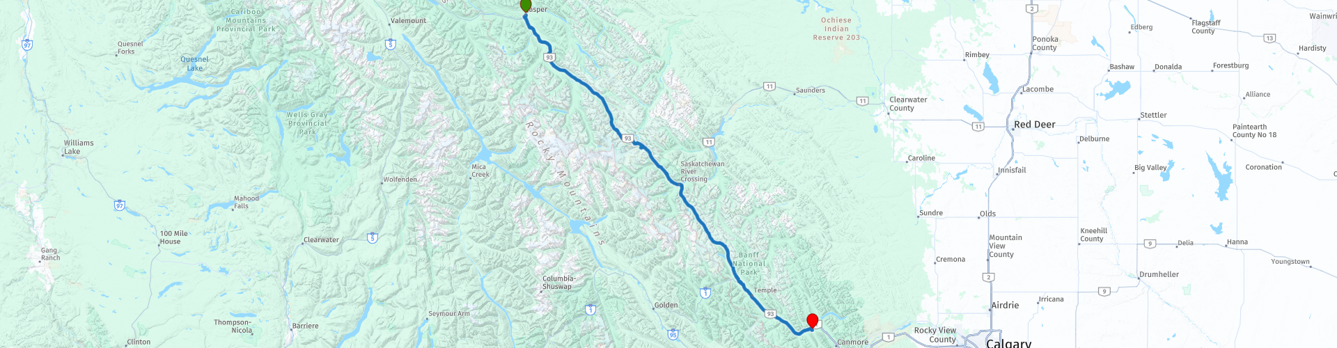
Starting point: Best Western Jasper Inn & Suites
End point: Best Western Siding 29 Lodge
The route has been made the same for TomTom, Garmin and MyRoute-app Navigation users.
Thanks to Richard & Lisa for the information!
 Share this route


Animation

Verdict


Duration
3h 43m

Mode of travel
Car or motorcycle

Distance
289.88 km

Countries

 RouteXpert Review
 It is therefore one of the largest ice masses under the Arctic Circle. With a specially designed vehicle - the Ice Explorer - it is possible from mid-April to mid-October to make a trip on the Athabasca glacier. Every eighty-minute trip departs from the Icefield Discovery Center and is led by an experienced guide who talks about the glaciers, ice fields and the surrounding area. During the ride you can get off to walk the glacier yourself.
The Columbia Icefield Highway takes us further through the Canadian Rockies. This 'highway' is actually a 'slow road' because there is little traffic. Along the way spectacular snow-capped mountain peaks, the famous Lake Louise, forests and: watch out for Grizzlies!
The lake is five kilometers from the town of Lake Louise and has an area of almost one kilometer. The Fairmont Chateau Hotel is located on the east bank. Lake Louise is a good base for walks in the area. Moraine Lake and Lake Agnes can be reached on foot from here. In the vicinity of Lake Louise you will find Emerald Lake (Yoho National Park), Bow Lake (Banff National Park), Lake O'Hara (Yoho National Park) and Peyto Lake (Banff National Park). In the summer, these glacial lakes turn beautifully green-blue. In the winter the lakes are covered with a
thick layer of ice and a large pack of snow. The destination is the famous winter sports resort of Banff, which is surrounded by glaciers. The spas and bath houses in Banff were the sights for the very first tourists. Take the Banff Gondola to the summit of Sulfur Mountain and enjoy the view of six different mountain ranges all year round (in good weather). The Banff Skywalk is a one-kilometer route along the mountain top.
Other sights in Banff National Park are the Bow Falls, a small, beautiful waterfall, and the Hoodoos Viewpoint. You see hoodoos here; narrow rock formations that resemble stone people. The bend where Tunnel Mountain Drive turns into Buffalo Street is popularly called 'Surprise Corner'. Here you have a surprisingly beautiful view of the Fairmont Banff Springs Hotel.
In this 4-star route you drive on beautiful good roads, through a breathtaking environment, you drive through a long mountain range. You should definitely do a lunch and ride over the glacier stop at the Columbia Icefield Glacier Adventure and Columbia Icefield Center.
History:
In the nineteenth century, the government wanted to build a railroad to connect British Columbia quickly and efficiently with densely populated Eastern Canada. Near the spot where nowadays the town of Banff is located, the Canadian Pacific Railway railway company encountered hot springs. The government needed money to finance the railroad and therefore wanted to turn the sources into a tourist attraction. The plan received a lot of resistance. The disagreement came to an end in 1885 when the government named the springs 'Hot Springs Reserve'. It became a protected area of 26 square kilometers, which could not be resold and where occupancy was prohibited. Two years later, on June 23, 1887, new territory was added to the Reserve. The nature reserve had 665 square kilometers and was named Rocky Mountains National Park - the first national park in Canada! Only in 1930 the name changed to Banff National Park.
For a sensible and sustainable management of the park, engineers thought about how to construct roads. In the meantime, resort communities have been built along the railway line, including Lake Louise. These were to make the long train journeys for passengers more comfortable. The hotels and bathhouses together formed a village: Banff, named after the Scottish region of Banffshire, where the directors of the railway company were born. When the car arrived, Banff National Park grew to become Canada's most visited national park. Various laws and pacts had to guarantee the sustainability of the park. Banff National Park even became World Heritage.
A recent event that increased the popularity of Banff National Park was a remarkable story about a squirrel. An American couple who wanted to photograph themselves with the help of the self-timer suddenly saw a ground squirrel appear in front of the lens. The photo, with the squirrel looking straight into the lens, has subsequently become the symbol of the relative tame nature of wild animals in Banff National Park on the internet.


 Links
Links  Usage
Usage Want to download this route?
You can download the route for free without MyRoute-app account. To do so, open the route and click 'save as'. Want to edit this route?
No problem, start by opening the route. Follow the tutorial and create your personal MyRoute-app account. After registration, your trial starts automatically.  Disclaimer
Use of this GPS route is at your own expense and risk. The route has been carefully composed and checked by a MyRoute-app accredited RouteXpert for use on TomTom, Garmin and MyRoute-app Navigation.
Changes may nevertheless have occurred due to changed circumstances, road diversions or seasonal closures. We therefore recommend checking each route before use.
Preferably use the route track in your navigation system. More information about the use of MyRoute-app can be found on the website under 'Community' or 'Academy'.