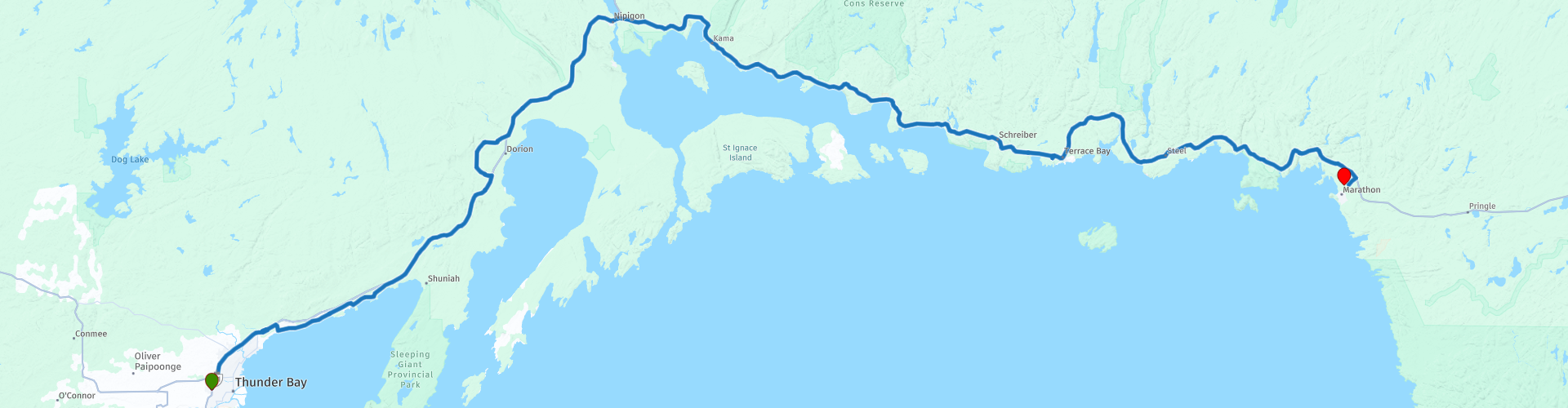
Day 15 TCH Thunder Bay to Marathon

This route was brought to you by:
RouteXpert René Plücken (MRA Master)
Last edit: 12-02-2021
 Route Summary
 This is part 15 that runs from Thunder Bay to Marathon.
The Trans Canada Highway passes through all the southern provinces of the country. The route can be driven in different ways. There are namely in various alternative routes that also belong to the TCH. The total distance is around 8,000 km. We not only drive the TCH, but will take the rural roads as much as possible, because only highway driving is too boring and Canada has many beautiful roads through its beautiful landscape.
You drive through all provinces and through very varied and scenic landscapes, from the Rockies in the West, the Central Prairies to the Eastern Maritimes and the Northern Forest.
The riding season is generally April through October with longer seasons on the west coast and southern Ontario.
Provide good all season clothing or bring rain gear, depending on the province and the season the weather can change and you may be surprised by a rain or even a snow or hail shower, so be prepared.
In Canada the metric system is used, so speeds are indicated in Km / h. A helmet requirement (DOT approved) applies throughout Canada.
You will see many wildlife throughout Canada. your similar animals from province to province, such as deer, buffalos, moose, caribou, wolves, pumas, bears, mountain goats, sheep, lynx, coyotes, foxes, raccoons, badgers, various rodents and all kinds of birds.
Even if it is very tempting to stop for a photo, don't do it, it can be very dangerous.
 Share this route


Animation

Verdict


Duration
4h 33m

Mode of travel
Car or motorcycle

Distance
315.35 km

Countries

 RouteXpert Review
 When we leave Thunder Bay we soon stop at the Terry Fox Monument (RP2), a public monument commemorating the Marathon of Hope of cancer researcher Terry Fox. The monument, which Fox proposes, is open to the public and offers panoramic views of Thunder Bay and its surroundings.
After this we leave the TCH for a short while to drive along McKenzie Beach Avenue along Amethyst Bay, a beautiful provincial and winding road along the bay, through the trees you can occasionally glimpse the bay. At Wild Goose Beach (RP3) we stop briefly to take a picture of the beautiful panorama.
After we are back on the TCH you can visit two Amethyst mines at RP7; the Blue Point and Diamond Willow Amethyst Mines. They offer self-guided & guided tours. The mine is an above-ground experience! No need to go underground to learn about amethyst and the amethyst mine and view the amethysts.
We continue on the TCH and Ouimet Canyon Road to Eagle Canyon Adventures (RP8) where you can walk over two breathtaking suspension bridges above the canyon. One bridge is 300ft or 91.44 meters long and the second bridge is Canada's longest at 600ft or 182.88 meters! Here is also Canada's longest and highest ZIP line: 1/2 mile (0.8 Km) long with speeds over 45 mph (72 Km / h)!
The next short stop to take a photo is at the Nipigon Look out Point (RP11), This is a metal structure on top of which you will be rewarded with a 360 degree view from Lake Helen, to the Nipigon River Bridge, to the marina and beyond . The Bridgeview Lookout Tower was completed through the Nipigon Waterfront Development Phase 1 Project with support from FedNor, the Northern Ontario Heritage Fund Corporation and the Township of Nipigon.
We continue on the De Nipigon River Bridge (RP12), a rigging bridge connecting Highway 11 and Highway 17, designated as part of the Trans-Canada Highway. A steel suspension road bridge built in 1937, parallel to an existing Canadian Pacific Railway bridge. In 1974 the original bridge was replaced by a steel plate girder construction.
We continue along the coastline of Nipigon Bay, along the way there are a number of points where you can stop briefly to take a photo, such as at Kama Bay Lookout (RP14).
In the small town of Schreiber we stop for a short lunch, many restaurants cannot be found along this route and at RP15 there is a converted train car where you can eat a quick bite.
Next stop is at De Aguasabon Waterfalls and Gorge (RP16) which is a breathtaking attraction not to be missed in Terrace Bay and along Lake Superior. With beautiful wildness in the spring and a serene grace in the summer and fall, this spectacular 30-meter waterfall flows into the Aguasabon Gorge, which flows along a 2.6 billion-year-old rock face. Truly breathtaking.
After this stop you can enjoy about 80 kilometers on lovely roads with beautiful panoramas to the end of this day, the small town of Marathon.
I appreciate this beautiful ride with 4 **** Stars, because of the beautiful roads, nature and sights along the route.


 Links
Links  Usage
Usage Want to download this route?
You can download the route for free without MyRoute-app account. To do so, open the route and click 'save as'. Want to edit this route?
No problem, start by opening the route. Follow the tutorial and create your personal MyRoute-app account. After registration, your trial starts automatically.  Disclaimer
Use of this GPS route is at your own expense and risk. The route has been carefully composed and checked by a MyRoute-app accredited RouteXpert for use on TomTom, Garmin and MyRoute-app Navigation.
Changes may nevertheless have occurred due to changed circumstances, road diversions or seasonal closures. We therefore recommend checking each route before use.
Preferably use the route track in your navigation system. More information about the use of MyRoute-app can be found on the website under 'Community' or 'Academy'.