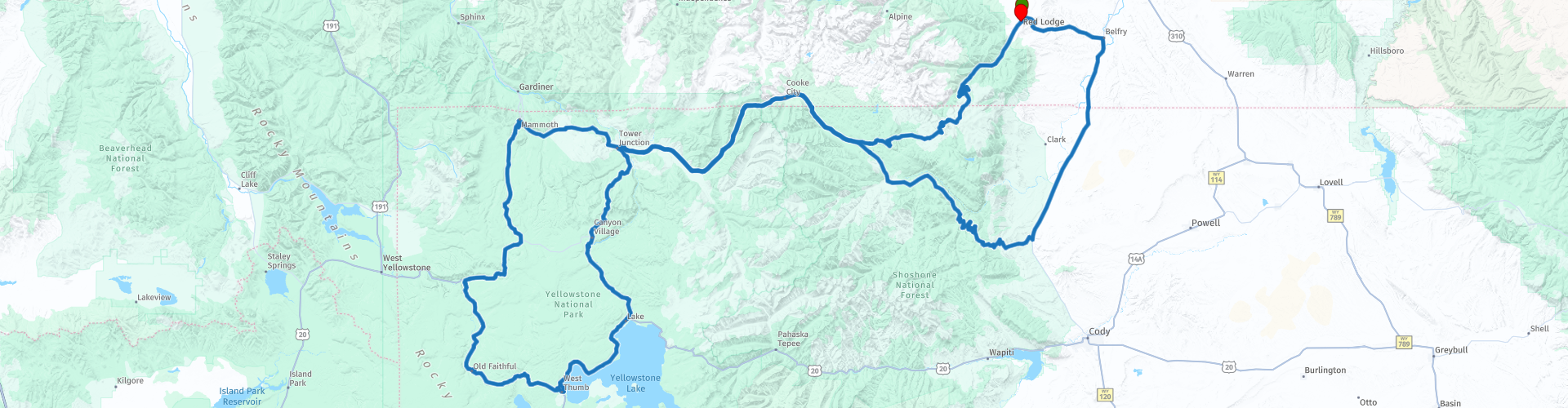
Red Lodge to Old Faithfull Two Day Round trip Beartooth Highway and Yellowstone Park

This route was brought to you by:
RouteXpert René Plücken (MRA Master)
Last edit: 20-08-2025
 Route Summary
 Along the way you can visit several beautiful sights in Yellowstone Park, there are beautiful lakes, waterfalls, and especially many geysers and mud pits.
Please note that the Beartooth Highway is not open year-round, so plan your trip in advance. The Beartooth Highway is best driven between late May and mid-October, when the road is generally open and accessible. However, due to the high elevation and unpredictable weather, the road can be temporarily closed even during these months.
I rate this ride 5 stars because of the beautiful winding roads and scenery
 Share this route


Animation

Verdict


Duration
33h 36m

Mode of travel
Car or motorcycle

Distance
542.80 km

Countries

 RouteXpert Review
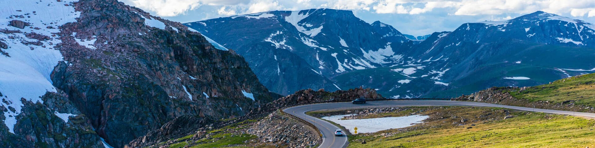
 The route features a series of steep zigzags and winding roads, following the Montana/Wyoming border to the 35,000-foot (10,847 m) Beartooth Pass, and requires an experienced rider. The estimated elevation gain is from 5,200 ft (1,600 m) to 8,000 ft (2,400 m) in 12 miles (19 km) of some of the most daring scenery.
Driving east-west, you'll reach the highest portions of the Beartooth Highway to a broad plateau at the top of the pass, then descend to the junction with Wyoming Highway 296 (Chief Joseph Scenic Byway) at Cooke City, the northeastern gateway to Yellowstone National Park.
Along the way you will pass numerous lakes typical of the Absaroka-Beartooth Wilderness Area that runs along much of the route. Take your time to enjoy the drive and stop to look around or park to admire the scenery and take photos. There are a number of campgrounds and picnic areas near the lakes that will make for great photo opportunities.
In Silver Gate (formerly part of Cooke City) you can plan lunch and fuel up, before we enter Yellowstone Park on the beautiful scenic road, along the route there are several parking areas where you can stop to enjoy the surroundings and take pictures, some of which are included in this review.
- Mammoth Hot Springs features a 3.5-mile trail with hiking trails past springs and a waterfall.
- Terrace Springs with a short walking trail on boardwalks along some beautiful springs.
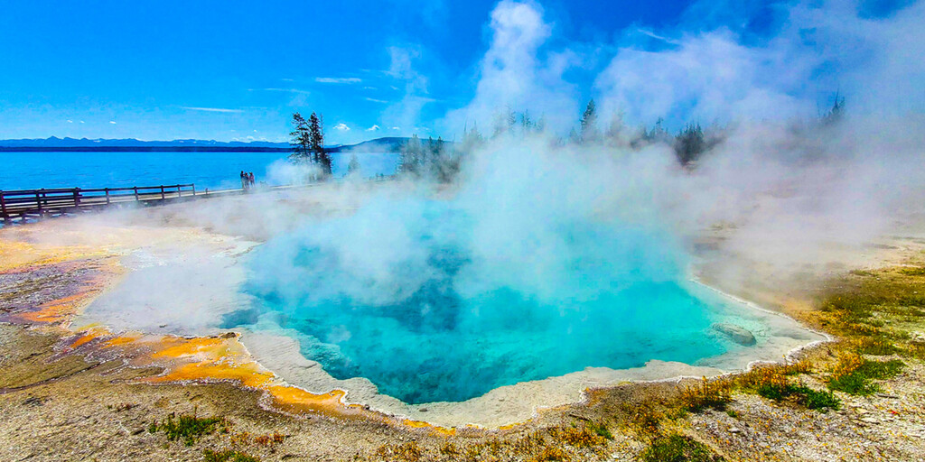
- Fountain Paint Pot Trail, where you will see several hydrothermal features that are expressions of the still active Yellowstone volcano. Within this geologic system, every type of thermal feature is represented. They can be grouped into two general categories - those with abundant water (hot springs and geysers) and those with limited water (mud pools and fumaroles). Despite their structural similarities, no two features are exactly alike.
- Bisquit Basin Trail is a beautiful scenic trail that passes through a number of geothermal features on a developed boardwalk. Closed due to an eruption on July 23, 2024.
We will be staying at the Old Faithful Inn, one of the most popular accommodations in Yellowstone National Park, so book in advance and early. This lodge is ideally situated overlooking the world-famous Old Faithful Geyser and offers many highlights and benefits you won’t find anywhere else. The inn has over 300 rooms available, including newly renovated suites and premium rooms that combine old-world and modern features that are a testament to Yellowstone’s history.
There are a number of waypoints included in this route where you can stop to take a picture of the beautiful scenery and the waterfalls;
- Kepler Cascades Waterfall, which flows rapidly through a rocky gorge just south of Old Faithful Village, draws large crowds of visitors to a region dominated by geysers.
- West Thumb Geyser Basin and Yellowstone Lake, the largest geyser basin on the shores of Yellowstone Lake (including Potts Basin to the north).
- The Fishing Bridge Visitor Center and Museum, a great place to stop. In this old wooden building you will discover the wide variety of wildlife that lives in and around the largest lake over 7,000 feet in North America. There are several animal displays in the visitor center including: grizzly bears, bald eagle, trumpeter swan and many more
- Le Hardy's Rapids is a section of the Yellowstone River where the riverbed drops slightly, throwing the water against large rocks and creating turbulent white water.
- The Brink of Lower Falls and Lower Lookout Point are incredible places to enjoy the view of the mighty Lower Falls of the Yellowstone River in Yellowstone. Be careful, the road to the parking lot is unpaved.
- Tower Falls, A short trail leads to the viewing platform. Tower Falls is a waterfall on Tower Creek in northeastern Yellowstone National Park, Wyoming, USA. About 1,000 meters upstream from the creek's confluence with the Yellowstone River, the falls plunge 132 feet.
In Canyon Village you can stop for lunch and fuel.
Once you have completed the Yellowstone Grand Loop, drive back via the Beartooth Highway to Red Lodge. Enjoy the drive back and it gives you a different perspective on the beautiful landscape.

 Links
Links  Usage
Usage Want to download this route?
You can download the route for free without MyRoute-app account. To do so, open the route and click 'save as'. Want to edit this route?
No problem, start by opening the route. Follow the tutorial and create your personal MyRoute-app account. After registration, your trial starts automatically.  Disclaimer
Use of this GPS route is at your own expense and risk. The route has been carefully composed and checked by a MyRoute-app accredited RouteXpert for use on TomTom, Garmin and MyRoute-app Navigation.
Changes may nevertheless have occurred due to changed circumstances, road diversions or seasonal closures. We therefore recommend checking each route before use.
Preferably use the route track in your navigation system. More information about the use of MyRoute-app can be found on the website under 'Community' or 'Academy'.