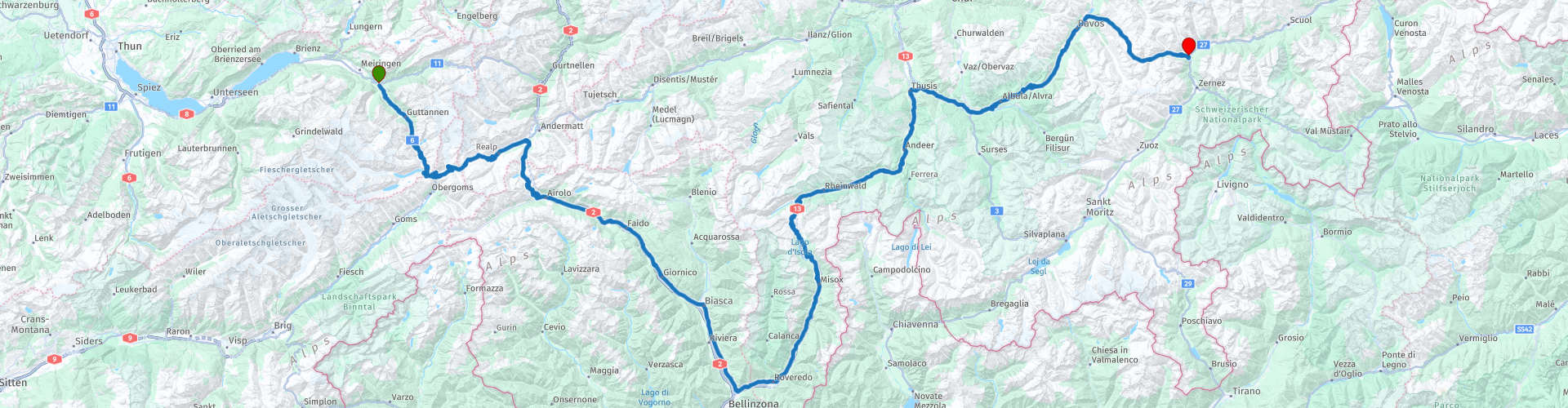
R04 Innertkirchen to Susch

This route was brought to you by:
RouteXpert Arno van Lochem - Senior RX
Last edit: 20-09-2022
 Route Summary
 In this route you drive, completely in and through Switzerland, from Innertkirchen to Susch, a small town at the foot of the Fluëla Pass. Immediately after the start of the route you will climb the Grimsel Pass, followed by the Furka and Gotthard Passes. The fourth pass you encounter is the San Bernardino, eventually the Fluëla pass closes the row of passes in the route.
Because of the beautiful passes, the great roads and all the beauty that can be seen along the way, this route deserves 5 stars.
Given the distances in mountainous areas and the many hairpin bends that can be very narrow at times, this route is suitable for the more advanced motorcyclist.
 Share this route


Animation

Verdict


Duration
9h 20m

Mode of travel
Car or motorcycle

Distance
302.74 km

Countries

 RouteXpert Review
 The route starts in Innertkirchen, shortly after the start you have a gas station on the right where you can fill up if necessary. The engine should start working immediately, as soon as you leave the village it starts to climb. Not only does the engine have to work, so does the driver, as the beautiful bends are not long in coming.
The Grimsel Pass connects the Swiss cantons of Bern (Innertkirchen) and Wallis (Gletsch) and is a watershed between the North Sea and the Mediterranean Sea. The current pass road was built in 1894. In the past, the pass, together with the Griespass further south, formed an important connection between northern Switzerland and Italy. The pass height is 2,165 meters.
From the north, the pass height can be reached via the Haslital. From Innertkirchen, a height difference of almost 1500 meters has to be overcome over a distance of 25 kilometers. The road is well developed, wide and nowhere particularly steep. At Handeck (RP3), the steepest funicular in Europe, the Gelmerbahn, has been leading to the Gelmersee since 1926 and a suspension bridge (Handeckfallbrücke) spans the very narrow valley at this place. Three large reservoirs are located near the pass height: the Grimselsee, the Räterichsbodensee and the Oberaarsee . The latter can be reached via a six kilometer long side road. This lake collects the melting water from the Oberaar Glacier, which lies on the eastern flank of the 4,274 meter high Finsteraarhorn. The Grimsel Pass hospiz is located on a rocky outcrop on a peninsula in the Grimselsee at 1,980 meters above sea level, from which you can also see the Rhone Glacier.
During the descent of the Grimsel pass you regularly see the Furka pass looming in front of you. At the bottom of the village of Gletsch, turn left and immediately turn onto the Furka Pass, undoubtedly known for the hotel closed (in 2015). Just before the top of the Furka Pass, in beautiful Switzerland, is the most famous and undoubtedly most photographed hotel in the Alps: Hotel Belvédère. The hotel was built in 1892 by the famous Seiler hotelier family from the fashionable Zermatt, exactly 25 years after the completion of the Furka Pass in 1867. The hotel has always been a risky investment: after all, the Furka Pass is closed in winter, so the season is but very short. The main attraction are the ice caves that run right through the adjacent Rhone Glacier. The hotel also provided shelter for those seeking tranquility, walkers and casual passers-by. In 1964, the famous chase scene from the James Bond film Goldfinger was shot on the Furka Pass. It is reported that Sean Connery was sleeping at the hotel at the time and remained a frequent visitor in the years that followed. Pope John the 23rd could also be counted among the regular clientele.
But things got harder and harder for a variety of reasons. Alternative roads were built through the Alps, reducing traffic on the Furka Pass and greatly reducing the number of passers-by. The glacier has now become more than a kilometer (!) shorter due to climate change, so that little is left of the once impressive ice caves.
When a rock formation hit the road between Göschenen and Andermatt in 2015, the main supply route from Lucerne was temporarily closed. Add to that the expensive Swiss Franc and the dire state of the rooms and the tenant had no choice but to close the doors.
It may not be interesting for everyone to do, but from the hotel in Innertkirchen it is about 80 km there and back to this hotel. If you have the opportunity, try to experience the sunrise at this hotel. You don't know what you see, beautiful how the sun comes out behind the mountains and puts the mountains in the sunlight. Yes, I know, you have to get out of bed at 4 a.m., but you get a lot in return. The first kilometers you drive up the Grimselpass in the dark. That's a bit different than in daylight! Curves that you would otherwise see coming suddenly loom up in front of you. Fortunately, the navigation does show them, which makes a difference. The navigation is soon assisted by the dawn that shines some light on the roads... After the visit, a delicious breakfast and a nice cup of coffee, then you have really started the day. And let's face it, it's not a punishment to drive the Grimsel and part of the Furka twice, is it?
Of course you can also drive it once, then you will have to discuss with the hotel owner of Hof und Post that you check out early.
After the Furka pass, the Gotthard pass is on the program. The climb from the north is not spectacular, unless you have to drive the part with cobblestones in the rain. That gives just that extra bit of tension to your ride.
Construction of the actual pass road was not started until 1826. The road was completed in 1830. The original pass road on the south side has been replaced by an easier route.
The former pass road, called Via Tremola, is still open to traffic, in fact, this route crosses the Tremola. Especially with a view to tourism by motorists, motorcyclists and, last but not least, cyclists. Near the Via Tremola, several hiking trails connect Airolo to the pass. Tremola is the name of the valley through which the route runs.
The fourth pass you drive in this route is the San Bernardino. Before you get there, however, you first have to drive 100 kilometers through the lower area. This is not a punishment at all, here too you are treated to hairpin and other pleasantly laid out bends. Between the acts you can stop for something to eat, after which the steering party continues.
After you have covered 180 km in the route you will drive on the San Bernardino pass with a pass height of 2066 meters. This pass (in Italian Passo San Bernardino) in the Lepontian Alps in Switzerland connects the German-speaking Hinterrhein Valley with the Italian-speaking Valle Mesolcina and was already used by the Romans. The pass is named after Saint Bernardine of Siena. The current route was built at the beginning of the nineteenth century (1818-1823). In 1968 the 6.6 kilometer long San Bernardino tunnel that runs under the pass was inaugurated. The road over the pass height is closed to traffic in winter, this period usually lasts from late October to early May.
After the fuel stop you come to Rofflaslucht where you can drink a cup of coffee. Weather permitting you should really sit outside here and enjoy the traffic passing by. This restaurant is located in a hairpin bend somewhere in between two passes, so a lot to see, including countless motorcyclists and sports cars.
In the last kilometers of this route you drive over the Fluëla pass, the 5th and last pass of today. The Flüelapass is a mountain pass in eastern Switzerland, in the canton of Graubünden between Davos and Susch. This pass, with a height of about 2400 meters, forms the main connection between the north of the Engadine and Davos. This pass is closed for a large part of the year because there is often still snow until well into May. Since the construction of the Vereinatunnel, a train tunnel with a car train between Klosters and Lavin in the Engadin, the north of the Engadin is also easily accessible when the Flüelapass is closed.
At the foot of the Fluëla Pass you arrive in the town of Susch. The route ends in this town, at hotel Garni Fluëla. Here too, the hostess does her best to make you feel at home.
Have fun driving this route!


 Links
Links  Usage
Usage Want to download this route?
You can download the route for free without MyRoute-app account. To do so, open the route and click 'save as'. Want to edit this route?
No problem, start by opening the route. Follow the tutorial and create your personal MyRoute-app account. After registration, your trial starts automatically.  Disclaimer
Use of this GPS route is at your own expense and risk. The route has been carefully composed and checked by a MyRoute-app accredited RouteXpert for use on TomTom, Garmin and MyRoute-app Navigation.
Changes may nevertheless have occurred due to changed circumstances, road diversions or seasonal closures. We therefore recommend checking each route before use.
Preferably use the route track in your navigation system. More information about the use of MyRoute-app can be found on the website under 'Community' or 'Academy'.

Bern
About this region
Bern (German: [bɛrn] (listen); Alemannic German: Bärn [b̥æːrn]) or Berne (French: [bɛʁn] (listen); Arpitan: Bèrna [ˈbɛʁna] (listen); Italian: Berna [ˈbɛrna]; Romansh: Berna [ˈbɛrnɐ] (listen)) is the de facto capital of Switzerland, referred to by the Swiss as their "federal city" (in German: Bundesstadt, French: ville fédérale, and Italian: città federale). With a population of about 144,000 (as of 2020), Bern is the fifth-most populous city in Switzerland. The Bern agglomeration, which includes 36 municipalities, had a population of 406,900 in 2014. The metropolitan area had a population of 660,000 in 2000.Bern is also the capital of the canton of Bern, the second-most populous of Switzerland's cantons. The official language is German, but the main spoken language is the local variant of the Alemannic Swiss German dialect, Bernese German. In 1983, the historic old town (in German: Altstadt) in the centre of Bern became a UNESCO World Heritage Site.
Read more on Wikipedia
View region
 Statistics
  29
29Amount of RX reviews (Bern)
 18979
18979Amount of visitors (Bern)
 1896
1896Amount of downloads (Bern)
 Route Collections in this region
 The 24 Most Beautiful Alpine Routes
The Alps, The Alps are a mountain range in Europe, stretching from the French Mediterranean coast in the southwest to the Pannonian Plain in the east. The area of the mountain range is more than 200,000 km².
In other words Passes and Mountain Roads!
Driving through the mountains is great! Especially over the mountain passes with hairpin bends and narrow winding roads. Every bend a different view where you can enjoy. There are many beautiful mountain passes in the Alps.
A selection that has also been incorporated into these routes:
The Stlevio Pass:
The Stelvio Pass, also known as Passo dello Stelvio, is mainly known for the stage in the Giro d'Italia. Due to the length and the difference in height, this pass is seen as one of the toughest tests in cycling. The Stelvio Pass reaches a maximum height of 2758 meters and is therefore one of the highest in the Alps. The pass connects the towns of Bormio and Prato Allo Stelvio. In winter the pass is closed due to heavy snowfall.
The Reschenpass:
The Reschenpass, also known as Passo di Resia, connects the Austrian state of Tyrol with the Italian province of South Tyrol. The pass reaches a maximum height of 1,504 meters and has been one of the most important north-south connections in the Alps in recent centuries. The pass was used long before Roman times. Along the way you will pass several highlights and historical relics. One of the highlights is the Reschensee. This lake was created after the construction of the dam and has completely submerged the village of Graun. The only thing that reminds of that is the clock tower in the middle of the lake.
Col du Galibier:
The French mountain pass Col du Galibier connects the towns of Saint-Michel-de-Maurienne and Briançon via the Col du Lautaret in the south and the Col du Télégraphe in the north. The mountain pass is part of the Tour de France and very much feared, due to the fact that it can only be reached via the other two mountain passes. The pass reaches a maximum height of 2646 meters. From there you can take a walk to the viewpoint at 2704 meters. You can admire the peaks of the Grand Galibier, Mont Blanc and La Meije here.
The Grossglockner High Alpine Road:
With a height of 3798 meters the Grossglockner is the highest mountain in Austria. To fully enjoy this impressive mountain, you can drive over the Grossglockner High Alpine Road and the accompanying pass. The route starts from Bruck am Grossglockner and ends in Heiligenblut. Of course you can drive in two directions. The pass reaches a maximum height of 2504 meters and is closed in winter due to heavy snowfall. Along the way you pass several stops with fun activities, information points, mountain huts and viewpoints. A visit to the Kaiser-Franz-Josefs-Höhe and Pasterzen Glacier is highly recommended.
The Col d'Izoard:
Just like the Col du Galibier, the Col d'Izoard is also part of a stage of the Tour de France. The mountain pass connects Briançon with the valley of the river Guil. The pass is partly located in the Regional Natural Park du Queyras and reaches a maximum height of 2360 meters. What is special about the Col d'Izoard is the barren and rocky landscape. Sometimes it feels like driving a car over the moon! Along the way you can stop at several points to enjoy the beautiful view.
The Bernina Pass:
The Bernina Express is one of the most famous rail trains in Switzerland and the Alps. The route is beautiful and partly included on the UNESCO World Heritage List. Parallel to the railway lies the Bernina pass, which connects the Veltlin valley with the Egandin valley. This beautiful Alpine road has a total length of 56 kilometers and reaches a maximum height of 2328 meters. Along the way you can enjoy views of the Morteratsch Glacier.
The Sella Pass:
The Sella Pass, also known as Passo di Sella, takes you over one of the most impressive mountain ranges in the Dolomites: the Sella massif. The pass connects Valle di Fassa with Val Gardena and reaches a maximum height of 2236 meters. At this height is also the border of the Italian provinces of Trentino and Bolzano. Along the way you can enjoy the view of this spectacular mountain world. Admire, for example, the three peaks of the Sasso Lungo massif, the Sella massif or the peaks of the Marmolada. You can also drive the Sella pass in combination with the Gardena pass, Pordoi pass and Campolongo pass.
The Grimsel Pass:
The Grimsel Pass connects Goms in Wallis with the Halis Valley in the Bernese Oberland. The pass reaches a maximum elevation of 2165 meters and is closed in winter due to snowfall. Over the centuries, the mountain pass has played an important role in trade between Switzerland and Italy. Now it is mainly the reservoirs that have an important function. These are used to generate electricity. The landscape you drive through is rugged, rocky and impressive. On top of the pass is a hotel and a restaurant with a special marmot park. The Dodensee (Totensee) is also located here. This lake owes its name to the many soldiers who died in the time of Napoleon.
The Gotthard Pass:
The Gotthard Pass, also known as Passo del San Gottardo and Saint Gotthard, connects the Swiss towns of Airolo and Andermatt. The mountain pass and associated tunnel are especially known among holidaymakers driving from Switzerland to Italy. But where the majority opt for the tunnel, it is precisely the pass that really completes the holiday. The Gotthard Pass has a length of about 26 kilometers and reaches a maximum height of 2106 meters. The route is beautiful and takes you along old villages and beautiful views.
The Silvretta High Alpine Road and Silvretta Pass:
The Paznaun Valley in Tyrol and the Montafon in Vorarlberg are connected by the Silvretta High Alpine Road. The route has a length of 22.3 kilometers and leads from Galtür to Partenen in 34 hairpin bends, via the 2032 meter high Bielerhöhe. The Silvrettasee is also located at this point, where you can enjoy a lovely walk. The pass is closed in winter due to snowfall.
The Simplon Pass:
Just like the Gotthard Pass, many holidaymakers also travel over the Simplon Pass every year. This mountain pass connects the Rhone Valley in the canton of Valais with the Valle d'Ossola in Piemonte. The pass is open all year round and reaches a maximum height of 2005 meters. Along the way you pass a number of buildings, including the well-known Simplon Hospiz from 1825. The hospiz is managed by the monks of St. Bernard. From the highest point on the pass, all kinds of hiking routes are possible and you will also come across a hotel where you can spend the night.
The Gerlos Pass:
The Gerlos Pass connects the Salzach Valley in the Salzburgerland with the Zillertal Valley in Tyrol. The pass is part of the Gerlos Alpenstraße and runs right through the Hohe Tauern National Park. Along the way you can enjoy beautiful views of the surroundings. The pass has a length of 12 kilometers and reaches a maximum height of 1531 meters. A ride over the Gerlos Pass can be ideally combined with a visit to the Krimmler Wasserfälle.
The Great St. Bernard Pass:
The Great St. Bernard Pass, better known as Col du Grand Saint Bernard, connects the Italian province of Valle d'Aosta with the Swiss canton of Valais. The pass is one of the highest in Switzerland and reaches a maximum height of 2469 meters. Like a number of other mountain passes in this list, the Great St. Bernard Pass has also been used as a connecting road for centuries. The pass is named after the St. Bernard dogs that used to help stranded travelers along with the monks. The pass is closed in winter.
The Timmelsjoch High Alpine Road:
The Timmelsjoch High Alpine Road connects the towns of Sölden in the Ötztal and Meran in South Tyrol. Tolls must be paid on the Hochgurgl - Moos route. Via a mountain road with about 60 hairpin bends you drive through a beautiful mountain world. With the Timmelsjoch Experience you can learn more about the history, the road and the environment via various stations. You can also visit the Top Mountain Crosspoint museum.
Col de l'Iseran:
With a maximum pass height of 2770 meters, the Col l'Iséran is one of the highest mountain passes in the Alps. The pass connects Bourg-Saint-Maurice with Bonneval-sur-Arc. Via a road full of hairpin bends you pass, among other things, Val-d'Isère and a side valley of the Maurienne that lies entirely in the National Park de la Vanoise. You can spot animals such as marmots and chamois and there is also a restaurant with a chapel on top of the pass.
The Gavia Pass:
The Gavia Pass (Italian Passo di Gavia) is a mountain pass in the Italian Alps, in the Lombardy region.
It is one of the highest pass roads in Europe. The road leads through the unspoilt Stelvio National Park. The road was built in the First World War to supply Italian soldiers who fought in the Italian-Austrian border area. The pass height is one of the most beautiful in the Alps. Here is the large Lago Bianco with, to the north, the mountain San Matteo (3684 meters). Lago Nero is slightly lower on the south side of the pass. Here the mountain group of the Adamello determines the view. There are many well-marked walks in the area. During the winter the pass is closed due to the heavy snowfall. The pass is often closed until May and June due to the large amount of snow.
Promoter has made a selection of the 24 Most Beautiful Alpine routes that they have set out in recent years.
The routes go through:
France
Austria
Switzerland
Italy
The most beautiful roads, the most beautiful views, the most beautiful viewpoints. The highest mountains, the fastest descents, hairpin bend after hairpin bend, you name it you can't get enough of it.
If you go on holiday in this region, take advantage of it, ALL routes in this collection have been checked and made equal for TomTom, Garmin and MyRoute-app Navigation by a MyRoute-app RouteXpert.
Have fun with this collection and while driving one of these routes. Enjoy all the beauty that the Alps and the Dolomites have to offer. Click on “View route” to read the review of the chosen route.
I would like to hear your findings about the route(s).
View Route Collection
11 day trip from the Netherlands
8 countries in 11 days; The Netherlands, Germany, Austria, Italy, Switzerland, France, Luxembourg and Belgium. This route collections consists of 10 routes that I have driven with friends in the summer of 2019.
The start is in Geldermalsen Netherlands, the first 7 days you drive through the Netherlands, Germany, Austria, Italy, Switzerland, France and a piece of Luxembourg with overnight stays in hotels.
The last three days you stay in Barweiler (D) in the Eifel and you drive two beautiful tours through the Eifel, Luxembourg and parts of the Belgian Ardennes.
There is no highway in the routes, only beautiful provincial and country roads, many beautiful passes with beautiful panoramas.
Be sure to check whether the passes are open before you leave.
These are routes for experienced drivers.
View Route Collection