Zeilberg Burgen

This route was brought to you by:
RouteXpert Hans van de Ven (Mr.MRA)
Last edit: 03-03-2019
 Route Summary
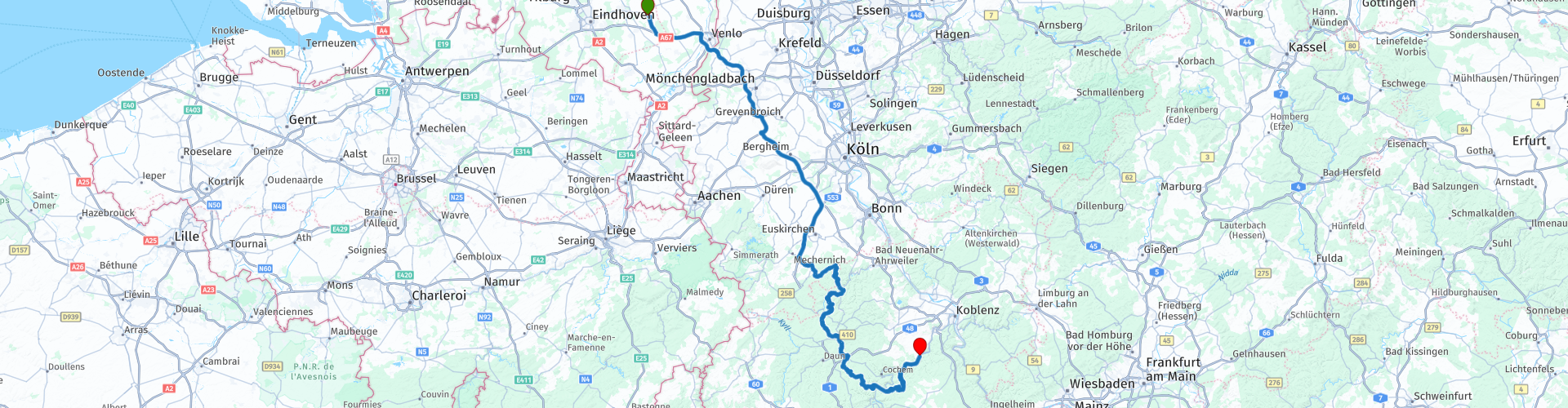
 Starting point: Café Zaal 't-Vertierke in Deurne (Zeilberg).
End point: Moselhotel Waldeck in Burgen.
 Share this route


Animation

Verdict


Duration
4h 59m

Mode of travel
Car or motorcycle

Distance
325.76 km

Countries


 RouteXpert Review
 * Burgen is a town in the German state of Rhineland-Palatinate, and is part of the Landkreis Mayen-Koblenz. Burgen lies at the mouth of the Baybach in the Mosel and has 713 inhabitants (Source: Wikipedia).
** The Moselle is a river in France, Luxembourg and Germany. Through the Our and the Sûre waters also parts of Belgium in the Mosel and Rhine. The Moselle rises at the Col de Bussang in the Vosges at 735 meters altitude and flows after 544 kilometers at Koblenz in the Rhine. (source: Wikipedia).
Because I have driven this route myself, this route gets 5 stars.
Route details:
The route is created for TomTom, Garmin and MyRoute-app Navigation users.
rp 3 - End of highway
rp 10 - Lunch in Kirchsahr
rp 35 - Refueling in Ediger-Eller.


 Links
Links  Usage
Usage Want to download this route?
You can download the route for free without MyRoute-app account. To do so, open the route and click 'save as'. Want to edit this route?
No problem, start by opening the route. Follow the tutorial and create your personal MyRoute-app account. After registration, your trial starts automatically.  Disclaimer
Use of this GPS route is at your own expense and risk. The route has been carefully composed and checked by a MyRoute-app accredited RouteXpert for use on TomTom, Garmin and MyRoute-app Navigation.
Changes may nevertheless have occurred due to changed circumstances, road diversions or seasonal closures. We therefore recommend checking each route before use.
Preferably use the route track in your navigation system. More information about the use of MyRoute-app can be found on the website under 'Community' or 'Academy'.

Hunsrück
About this region
The Hunsrück (German pronunciation: [ˈhʊnsʁʏk]) is a long, triangular, pronounced upland in Rhineland-Palatinate, Germany. It is bounded by the valleys of the Moselle-Saar (north-to-west), the Nahe (south), and the Rhine (east). It is continued by the Taunus mountains, past the Rhine and by the Eifel past the Moselle. To the south of the Nahe is a lower, hilly country forming the near bulk of the Palatinate region and all of the, smaller, Saarland. Below its north-east corner is Koblenz.
As the Hunsrück proceeds east it acquires north-south width and three notable gaps in its southern ridges. In this zone are multi-branch headwaters including the Simmerbach ending at Simmertal on the southern edge. This interior is therefore rarely higher than 450 metres (1,480 ft) above sea level. Peaks and escarpments are principally: the (Black Forest) Hochwald, the Idar Forest, the Soonwald, and the Bingen Forest. The highest mountain is the Erbeskopf (816 m; 2,677 ft), towards the region's south-west.
Notable towns are Simmern, Kirchberg, and Idar-Oberstein, Kastellaun, and Morbach. Frankfurt-Hahn Airport is at the centre of the upland, equidistant between Mainz, Trier and Koblenz, co-named after the village of Hahn.
Slate is still mined in the mountains. Since 2010, the region has become one of Germany's major onshore wind power regions. Large wind farms are near Ellern and Kirchberg. Nature-based tourism is widespread. In 2015, a new national park was inaugurated. The pedestrian Geierlay suspension bridge opened in the same year. The climate sees mists that rise most mornings. More rain than the German average is caused by a combination of an oceanic influence and relief precipitation.
Culturally, the region is best known for its Hunsrückisch dialect and through depictions in the Heimat film series. The region saw great emigration in the mid-19th century, particularly to Brazil.
Read more on Wikipedia
As the Hunsrück proceeds east it acquires north-south width and three notable gaps in its southern ridges. In this zone are multi-branch headwaters including the Simmerbach ending at Simmertal on the southern edge. This interior is therefore rarely higher than 450 metres (1,480 ft) above sea level. Peaks and escarpments are principally: the (Black Forest) Hochwald, the Idar Forest, the Soonwald, and the Bingen Forest. The highest mountain is the Erbeskopf (816 m; 2,677 ft), towards the region's south-west.
Notable towns are Simmern, Kirchberg, and Idar-Oberstein, Kastellaun, and Morbach. Frankfurt-Hahn Airport is at the centre of the upland, equidistant between Mainz, Trier and Koblenz, co-named after the village of Hahn.
Slate is still mined in the mountains. Since 2010, the region has become one of Germany's major onshore wind power regions. Large wind farms are near Ellern and Kirchberg. Nature-based tourism is widespread. In 2015, a new national park was inaugurated. The pedestrian Geierlay suspension bridge opened in the same year. The climate sees mists that rise most mornings. More rain than the German average is caused by a combination of an oceanic influence and relief precipitation.
Culturally, the region is best known for its Hunsrückisch dialect and through depictions in the Heimat film series. The region saw great emigration in the mid-19th century, particularly to Brazil.
View region
 Statistics
  43
43Amount of RX reviews (Hunsrück)
 16253
16253Amount of visitors (Hunsrück)
 7484
7484Amount of downloads (Hunsrück)
 Route Collections in this region
 11 day trip from the Netherlands
8 countries in 11 days; The Netherlands, Germany, Austria, Italy, Switzerland, France, Luxembourg and Belgium. This route collections consists of 10 routes that I have driven with friends in the summer of 2019.
The start is in Geldermalsen Netherlands, the first 7 days you drive through the Netherlands, Germany, Austria, Italy, Switzerland, France and a piece of Luxembourg with overnight stays in hotels.
The last three days you stay in Barweiler (D) in the Eifel and you drive two beautiful tours through the Eifel, Luxembourg and parts of the Belgian Ardennes.
There is no highway in the routes, only beautiful provincial and country roads, many beautiful passes with beautiful panoramas.
Be sure to check whether the passes are open before you leave.
These are routes for experienced drivers.
View Route Collection
Route collection hairpins in the Eifel
This collection is composed of the most beautiful and winding roads in the Eifel. Forget Bundesstraßen, forget the road along the Moselle, if you have driven these roads, you can really say that you have been to the Eifel.
No less than 6 routes and 1,800 kilometers are waiting for you!
No less than 6 routes and 1,800 kilometers are waiting for you!
View Route Collection