Morbach naar Dasburg

This route was brought to you by:
RouteXpert Frank
Last edit: 17-02-2019
 Route Summary
 Planning to drive is in May 2019
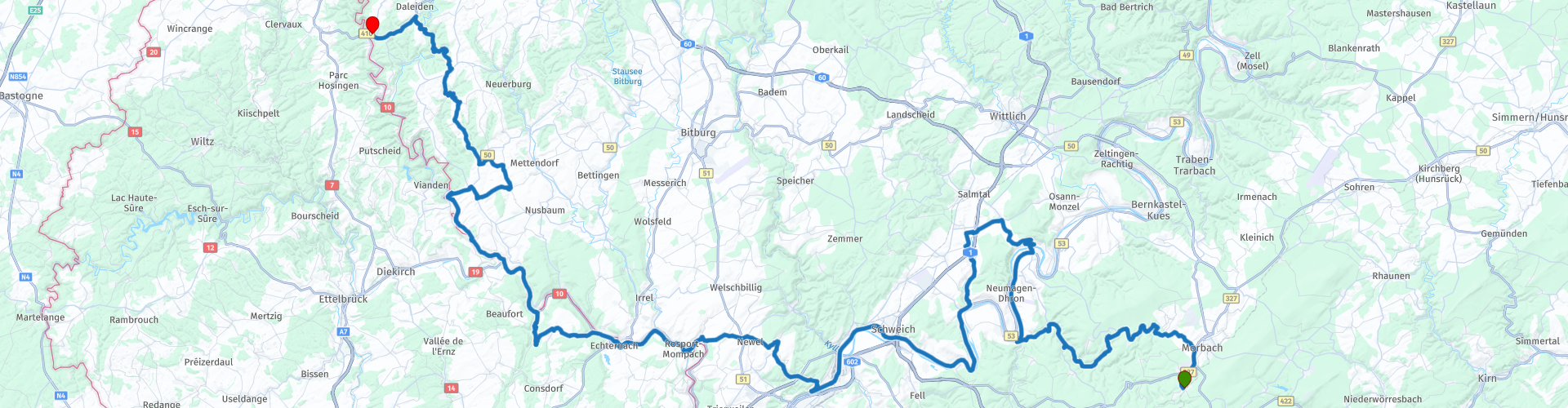
Starting point: Motorhotel Gus in Morbach
End point: Motorhotel Daytona in Dasburg
 Share this route


Animation

Verdict


Duration
3h 6m

Mode of travel
Car or motorcycle

Distance
173.34 km

Countries


 RouteXpert Review
 The route starts immediately with small winding roads towards Piesport.
This place is right on the Moselle, and is a wine village with about 1900 inhabitants on the right bank between Trier and Bernkastel. It is surrounded by steep mountains, and this colossal rock massif is also called the Mosel - Loreley.
As soon as we cross the Mosel we begin the characteristic hairpin bends above Piesport. Three quarters of the climb up. We stop for coffee and a delicious view over the Mosel.
When we leave again we have a little more than an hour to send over wonderful roads, before we arrive in Echternach where we find a lunch location.
The center of Echternach is largely car-free. The city is popular with tourists and that is evident from the many restaurants, cafes, cafes and hotels in the historic center.
After lunch it is just a 10-minute drive to the next stop at Mullerthal. This area is often called Luxembourg's Little Switzerland. This is due to the undulating landscape that reminds one of Switzerland. Mullerthal is above all an exceptional biotope characterized by awe-inspiring rock formations. The composition of rocks and their erosion have created the landscape that is so typical of Luxembourg's Little Switzerland.
After having seen this fantastic rock party, it is about 1 hour and 15 minutes drive to Dasburg, the terminus of this route.
I have given this route 4 stars. This is because I have not driven this route in this configuration yet. However many pieces of this route have already been driven from previous routes.
Route comments:
rp 4 - Coffee stop + view at Hotel Moselpanorama
rp 10 - Short walk and lunch in Echternach at one of the many restaurants or terraces
rp 11 - Photo moment, also climb the rock formations


 Links
Links  Usage
Usage Want to download this route?
You can download the route for free without MyRoute-app account. To do so, open the route and click 'save as'. Want to edit this route?
No problem, start by opening the route. Follow the tutorial and create your personal MyRoute-app account. After registration, your trial starts automatically.  Disclaimer
Use of this GPS route is at your own expense and risk. The route has been carefully composed and checked by a MyRoute-app accredited RouteXpert for use on TomTom, Garmin and MyRoute-app Navigation.
Changes may nevertheless have occurred due to changed circumstances, road diversions or seasonal closures. We therefore recommend checking each route before use.
Preferably use the route track in your navigation system. More information about the use of MyRoute-app can be found on the website under 'Community' or 'Academy'.

Hunsrück
About this region
The Hunsrück (German pronunciation: [ˈhʊnsʁʏk]) is a long, triangular, pronounced upland in Rhineland-Palatinate, Germany. It is bounded by the valleys of the Moselle-Saar (north-to-west), the Nahe (south), and the Rhine (east). It is continued by the Taunus mountains, past the Rhine and by the Eifel past the Moselle. To the south of the Nahe is a lower, hilly country forming the near bulk of the Palatinate region and all of the, smaller, Saarland. Below its north-east corner is Koblenz.
As the Hunsrück proceeds east it acquires north-south width and three notable gaps in its southern ridges. In this zone are multi-branch headwaters including the Simmerbach ending at Simmertal on the southern edge. This interior is therefore rarely higher than 450 metres (1,480 ft) above sea level. Peaks and escarpments are principally: the (Black Forest) Hochwald, the Idar Forest, the Soonwald, and the Bingen Forest. The highest mountain is the Erbeskopf (816 m; 2,677 ft), towards the region's south-west.
Notable towns are Simmern, Kirchberg, and Idar-Oberstein, Kastellaun, and Morbach. Frankfurt-Hahn Airport is at the centre of the upland, equidistant between Mainz, Trier and Koblenz, co-named after the village of Hahn.
Slate is still mined in the mountains. Since 2010, the region has become one of Germany's major onshore wind power regions. Large wind farms are near Ellern and Kirchberg. Nature-based tourism is widespread. In 2015, a new national park was inaugurated. The pedestrian Geierlay suspension bridge opened in the same year. The climate sees mists that rise most mornings. More rain than the German average is caused by a combination of an oceanic influence and relief precipitation.
Culturally, the region is best known for its Hunsrückisch dialect and through depictions in the Heimat film series. The region saw great emigration in the mid-19th century, particularly to Brazil.
Read more on Wikipedia
As the Hunsrück proceeds east it acquires north-south width and three notable gaps in its southern ridges. In this zone are multi-branch headwaters including the Simmerbach ending at Simmertal on the southern edge. This interior is therefore rarely higher than 450 metres (1,480 ft) above sea level. Peaks and escarpments are principally: the (Black Forest) Hochwald, the Idar Forest, the Soonwald, and the Bingen Forest. The highest mountain is the Erbeskopf (816 m; 2,677 ft), towards the region's south-west.
Notable towns are Simmern, Kirchberg, and Idar-Oberstein, Kastellaun, and Morbach. Frankfurt-Hahn Airport is at the centre of the upland, equidistant between Mainz, Trier and Koblenz, co-named after the village of Hahn.
Slate is still mined in the mountains. Since 2010, the region has become one of Germany's major onshore wind power regions. Large wind farms are near Ellern and Kirchberg. Nature-based tourism is widespread. In 2015, a new national park was inaugurated. The pedestrian Geierlay suspension bridge opened in the same year. The climate sees mists that rise most mornings. More rain than the German average is caused by a combination of an oceanic influence and relief precipitation.
Culturally, the region is best known for its Hunsrückisch dialect and through depictions in the Heimat film series. The region saw great emigration in the mid-19th century, particularly to Brazil.
View region
 Statistics
  65
65Amount of RX reviews (Hunsrück)
 17358
17358Amount of visitors (Hunsrück)
 10818
10818Amount of downloads (Hunsrück)
 Route Collections in this region
 11 day trip from the Netherlands
8 countries in 11 days; The Netherlands, Germany, Austria, Italy, Switzerland, France, Luxembourg and Belgium. This route collections consists of 10 routes that I have driven with friends in the summer of 2019.
The start is in Geldermalsen Netherlands, the first 7 days you drive through the Netherlands, Germany, Austria, Italy, Switzerland, France and a piece of Luxembourg with overnight stays in hotels.
The last three days you stay in Barweiler (D) in the Eifel and you drive two beautiful tours through the Eifel, Luxembourg and parts of the Belgian Ardennes.
There is no highway in the routes, only beautiful provincial and country roads, many beautiful passes with beautiful panoramas.
Be sure to check whether the passes are open before you leave.
These are routes for experienced drivers.
View Route Collection
Route collection hairpins in the Eifel
This collection is composed of the most beautiful and winding roads in the Eifel. Forget Bundesstraßen, forget the road along the Moselle, if you have driven these roads, you can really say that you have been to the Eifel.
No less than 6 routes and 1,800 kilometers are waiting for you!
No less than 6 routes and 1,800 kilometers are waiting for you!
View Route Collection