Nederweert Baiersbronn

This route was brought to you by:
RouteXpert Hans van de Ven (Mr.MRA)
Last edit: 29-12-2020
 Route Summary
 Route on May 20, 2019 corrected based on the recorded Track.
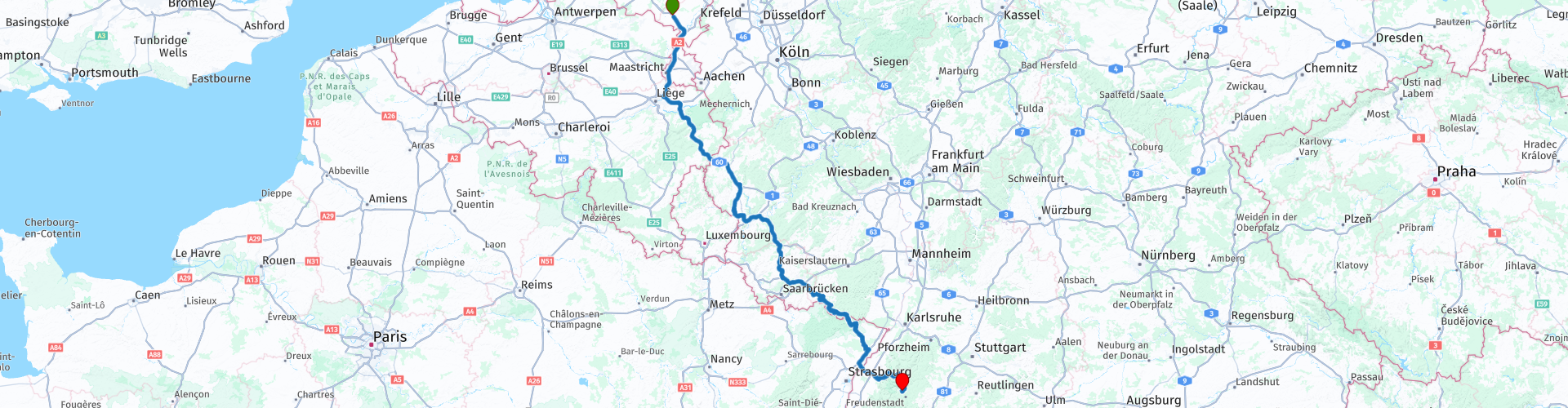
Starting point: AC Restaurant Nederweert Zuid
End point: Hotel Falken Baiersbronn.
Route made equal for Garmin, TT and MyRoute-app Navigation.
 Share this route


Animation

Verdict


Duration
7h 0m

Mode of travel
Car or motorcycle

Distance
537.12 km

Countries


 RouteXpert Review
 We decided to leave early at 7 AM at AC Restaurant Nederweert Zuid along the A2. We are all there on time, so at 6:45 am we set sail for Baiersbronn.
The 1st part to Bitburg is largely on the highway, after all we have to cover 537 KM today. The journey goes well, little traffic on the road around this time. In Bitburg we refuel and drink a cup of coffee. After coffee it goes a bit inside and then we go back on the highway for 120 km.
The second part is also making good progress, still with little traffic on the road, but unfortunately we discover that not everything is open yet where we want to stop, so you can see that the information on the internet is not always correct either. No worries, we have an emergency ration with us in the top case, so that if necessary we do something about it. We leave the highway behind us to drive in until next Saturday, we start just above the French border in Walshausen.
It is now time to have lunch, we stop in Fischbach bei Dahn at Landhaus Tausendschön. After lunch it continues and we enter the Vosges, this is also a very nice area to drive through, after we have crossed the Rhine, we are back in Germany and we are preparing for the last part, we are getting acquainted with the B500, the Schwarzwaldhochstraße *
* The Schwarzwaldhochstraße is an impressive, wide road that runs through the Black Forest. Another well-known name for this route is also B500. The winding route goes through the nature park and runs from Baden-Baden to Freudenstadt, at heights from 800 meters to a kilometer. The road offers visitors an enchanting view of the Rhine Valley and the Vosges. Not to mention that the beautiful nature certainly invites you to walk, take pictures and enjoy the sights along this route.
After the Schwarzwaldhochstraße we continue on to Baiersbronn, where we fill up a few kilometers in front of the hotel, so that we can set off again tomorrow with a full tank.
Because we have driven this route ourselves, we rate it with 5 stars.
Route details:
rp 1 - Departure point, AC Restaurant Nederweert Zuid
rp 5 - ARAL Bitburg, Tanks and Coffee
rp 22 - P-Walshausen, something from the emergency ration and stretching your legs. (Because planned location was closed)
rp 26 - ed-Tankstelle (if required)
rp 29 - Lunch stop at Landhaus Tausendschön
rp 43 - Tank stop in Baiersbronn
rp 45 - Hotel Falken Baiersbronn


 Links
Links  Usage
Usage Want to download this route?
You can download the route for free without MyRoute-app account. To do so, open the route and click 'save as'. Want to edit this route?
No problem, start by opening the route. Follow the tutorial and create your personal MyRoute-app account. After registration, your trial starts automatically.  Disclaimer
Use of this GPS route is at your own expense and risk. The route has been carefully composed and checked by a MyRoute-app accredited RouteXpert for use on TomTom, Garmin and MyRoute-app Navigation.
Changes may nevertheless have occurred due to changed circumstances, road diversions or seasonal closures. We therefore recommend checking each route before use.
Preferably use the route track in your navigation system. More information about the use of MyRoute-app can be found on the website under 'Community' or 'Academy'.

Hunsrück
About this region
The Hunsrück (German pronunciation: [ˈhʊnsʁʏk]) is a long, triangular, pronounced upland in Rhineland-Palatinate, Germany. It is bounded by the valleys of the Moselle-Saar (north-to-west), the Nahe (south), and the Rhine (east). It is continued by the Taunus mountains, past the Rhine and by the Eifel past the Moselle. To the south of the Nahe is a lower, hilly country forming the near bulk of the Palatinate region and all of the, smaller, Saarland. Below its north-east corner is Koblenz.
As the Hunsrück proceeds east it acquires north-south width and three notable gaps in its southern ridges. In this zone are multi-branch headwaters including the Simmerbach ending at Simmertal on the southern edge. This interior is therefore rarely higher than 450 metres (1,480 ft) above sea level. Peaks and escarpments are principally: the (Black Forest) Hochwald, the Idar Forest, the Soonwald, and the Bingen Forest. The highest mountain is the Erbeskopf (816 m; 2,677 ft), towards the region's south-west.
Notable towns are Simmern, Kirchberg, and Idar-Oberstein, Kastellaun, and Morbach. Frankfurt-Hahn Airport is at the centre of the upland, equidistant between Mainz, Trier and Koblenz, co-named after the village of Hahn.
Slate is still mined in the mountains. Since 2010, the region has become one of Germany's major onshore wind power regions. Large wind farms are near Ellern and Kirchberg. Nature-based tourism is widespread. In 2015, a new national park was inaugurated. The pedestrian Geierlay suspension bridge opened in the same year. The climate sees mists that rise most mornings. More rain than the German average is caused by a combination of an oceanic influence and relief precipitation.
Culturally, the region is best known for its Hunsrückisch dialect and through depictions in the Heimat film series. The region saw great emigration in the mid-19th century, particularly to Brazil.
Read more on Wikipedia
As the Hunsrück proceeds east it acquires north-south width and three notable gaps in its southern ridges. In this zone are multi-branch headwaters including the Simmerbach ending at Simmertal on the southern edge. This interior is therefore rarely higher than 450 metres (1,480 ft) above sea level. Peaks and escarpments are principally: the (Black Forest) Hochwald, the Idar Forest, the Soonwald, and the Bingen Forest. The highest mountain is the Erbeskopf (816 m; 2,677 ft), towards the region's south-west.
Notable towns are Simmern, Kirchberg, and Idar-Oberstein, Kastellaun, and Morbach. Frankfurt-Hahn Airport is at the centre of the upland, equidistant between Mainz, Trier and Koblenz, co-named after the village of Hahn.
Slate is still mined in the mountains. Since 2010, the region has become one of Germany's major onshore wind power regions. Large wind farms are near Ellern and Kirchberg. Nature-based tourism is widespread. In 2015, a new national park was inaugurated. The pedestrian Geierlay suspension bridge opened in the same year. The climate sees mists that rise most mornings. More rain than the German average is caused by a combination of an oceanic influence and relief precipitation.
Culturally, the region is best known for its Hunsrückisch dialect and through depictions in the Heimat film series. The region saw great emigration in the mid-19th century, particularly to Brazil.
View region
 Statistics
  43
43Amount of RX reviews (Hunsrück)
 16253
16253Amount of visitors (Hunsrück)
 7484
7484Amount of downloads (Hunsrück)
 Route Collections in this region
 11 day trip from the Netherlands
8 countries in 11 days; The Netherlands, Germany, Austria, Italy, Switzerland, France, Luxembourg and Belgium. This route collections consists of 10 routes that I have driven with friends in the summer of 2019.
The start is in Geldermalsen Netherlands, the first 7 days you drive through the Netherlands, Germany, Austria, Italy, Switzerland, France and a piece of Luxembourg with overnight stays in hotels.
The last three days you stay in Barweiler (D) in the Eifel and you drive two beautiful tours through the Eifel, Luxembourg and parts of the Belgian Ardennes.
There is no highway in the routes, only beautiful provincial and country roads, many beautiful passes with beautiful panoramas.
Be sure to check whether the passes are open before you leave.
These are routes for experienced drivers.
View Route Collection
Route collection hairpins in the Eifel
This collection is composed of the most beautiful and winding roads in the Eifel. Forget Bundesstraßen, forget the road along the Moselle, if you have driven these roads, you can really say that you have been to the Eifel.
No less than 6 routes and 1,800 kilometers are waiting for you!
No less than 6 routes and 1,800 kilometers are waiting for you!
View Route Collection