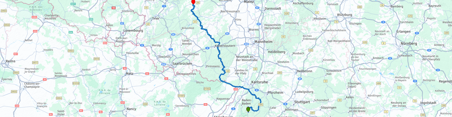
R06 - Forbach to Kirchberg

This route was brought to you by:
RouteXpert Arno van Lochem - Senior RX
Last edit: 01-12-2020
 Route Summary
 The Eifel is the eastern part of the medium-high plateau Eifel-Ardennes. It is located north of the Moselle and west of the Rhine. The largest part is located in Germany, a small part is in Belgium, in the East Cantons. The German part of the Eifel is located in the states of North Rhine-Westphalia and Rhineland-Palatinate. The highest point is the Hohe Acht at 747 meters.
This route starts in Forbach at Hotel Das Waldhaus and runs from the northern part of the Black Forest via a small part of France towards the Eifel. You drive through the beautiful expansive Pfälzerwald. The route ends in Kirchberg at Landhotel Karrenberg, a beautiful outdoor hotel where life is good.
 Share this route


Animation

Verdict


Duration
8h 6m

Mode of travel
Car or motorcycle

Distance
287.73 km

Countries

 RouteXpert Review
 The route starts at the Hotel Das Waldhaus, located on the outskirts of Forbach at the Holzbrücke, a bridge with a rich history. In 1777, the construction of a covered wooden bridge without a central pillar was planned according to the plans of engineer Otto Lindemann. A year later, in the fall of 1778, the bridge was completed. The Forbacher wooden bridge was built by master carpenter Johannes Daselmeier from Gernsbach for the price of 1150 guilders. 2714 linear meters thick oak planks were used, for which 150 "Methuselah oaks" were cut. The maintenance was financed by means of a toll.
Although the bridge was provided with a new roof in 1926, the bridge was nevertheless closed in 1930 for safety reasons for loaded carts. Almost 20 years later it still went wrong ...
To avoid conquest by the Allies, numerous bridges were blown up in the Murg Valley towards the end of the war. The historic old wooden bridge in Forbach was 'confiscated' as a replacement bridge. However, it was exposed to enormous charges, in April 1945 French tanks drove over it! This resulted in permanent deflection, causing the bridge to deteriorate more and more.
In 1954 the old dilapidated bridge was dismantled, in 1955 rebuilding to original design started. On May 11, 1955, the new "Old Wooden Bridge" was inaugurated: the covered wooden bridge with the special arch has been the townscape of Forbach for more than 200 years.
After you have left Forbach with its historic bridge, you wind the first 35 kilometers through the beautiful northern part of the Black Forest. After 20 kilometers you will drive over the actually only pass with a little height of today, namely 933 meters.
Slowly but surely you notice that you are leaving the Black Forest behind. To enjoy the heights that this forest offers you one more time 'at height', you can turn in Bad Wildbad towards Wildline.
This park offers you various options. You can walk between the treetops via the 'baumwipfelpad' or the treetop path at a height of 20 meters. A walk of 1250 meters with a 40 meter high tower at the end which of course gives you a great view of the area.
If you are looking for even more adventure, you can venture across the 380-meter-long Wildline suspension bridge. With a little courage and a thirst for adventure, you can cross the breathtaking construction at an altitude of about 60 meters. With a fantastic view you can enjoy a breathtaking view over the northern Black Forest.
Not only the experience of nature, but also the ingenious construction makes the suspension bridge so unique. Unlike the usual hanging rope bridges, the bridge leads you up and in the middle of the bridge you have reached the highest point. You feel like you are floating above the Black Forest. Obviously, you can take beautiful pictures from this point! For more information about Wildline and the Baumwipfelpad see the links below.
After all this high natural disaster it is time to follow some asphalt again, after all you have another 250 kilometers to go! The route meanders to the north and at Neuburgweier you cross the Rhine with a small ferry (see link below for information about departures, etc.). You have just arrived in Germany, so you can still order the coffee at the break scheduled here in German.
After the break you cross the French border after about 5 kilometers. However, you do not drive long on French territory, because about 20 kilometers later you exchange France for Germany again. You meander through a beautiful hilly area that stands out for its endless forests. You drive here in the Palatinate Forest. This nature park was founded in 1958. At the time it was one of the first nature parks in Germany and today, with an area of 179,000 hectares, it is one of the largest nature parks in Germany. A great piece of nature to drive through on a motorcycle.
It is not surprising that in the middle of this beautiful area, about 10 kilometers below Kaiserslautern, a lunch break has been inserted at restaurant Johanniskreuz.
After lunch you continue the route to the north, ignoring the aforementioned Kaiserslautern. About 20 kilometers before the end of the route you can visit the Schmidtburg. The Schmidtburg is one of the oldest and most important civil structures in this area. Its history dates back to 926, when three Frankish nobles exchanged land with the Monastery of St. Maximin in Trier to build a fortress as protection against the Hungarians who threatened the region at the time.
There are many indications that this castle refers to the Schmidtburg. It is likely that this medieval structure was designed as a retreat and had little in common with the present castle, the ruins of which we can still see today.
In the late sixties, scouting associations started with the first clean-up campaigns, after which the Ortsgemeinde Schneppenbach began to carefully secure the ruin in the years 1972 - 1975. In the 1980s, further excavations and repairs were carried out as part of employment programs, making the castle accessible again.
For example, this important monumental building is preserved as a monument to local history and possibly stimulates interest in its own history.
It is not unimportant to mention that the castle grounds are free for everyone. A visit to Schmidtburg is certainly worthwhile. For more information you can consult the link below.
After this ruin you will reach the end of this route after 20 kilometers, Landhotel Karrenberg in Kirchberg. A hotel in a great location in the middle of nature. Beautiful views from the terrace, which makes the beer taste extra good.
Have fun driving this route!


 Links
Links  Usage
Usage Want to download this route?
You can download the route for free without MyRoute-app account. To do so, open the route and click 'save as'. Want to edit this route?
No problem, start by opening the route. Follow the tutorial and create your personal MyRoute-app account. After registration, your trial starts automatically.  Disclaimer
Use of this GPS route is at your own expense and risk. The route has been carefully composed and checked by a MyRoute-app accredited RouteXpert for use on TomTom, Garmin and MyRoute-app Navigation.
Changes may nevertheless have occurred due to changed circumstances, road diversions or seasonal closures. We therefore recommend checking each route before use.
Preferably use the route track in your navigation system. More information about the use of MyRoute-app can be found on the website under 'Community' or 'Academy'.

Hunsrück
About this region
The Hunsrück (German pronunciation: [ˈhʊnsʁʏk]) is a long, triangular, pronounced upland in Rhineland-Palatinate, Germany. It is bounded by the valleys of the Moselle-Saar (north-to-west), the Nahe (south), and the Rhine (east). It is continued by the Taunus mountains, past the Rhine and by the Eifel past the Moselle. To the south of the Nahe is a lower, hilly country forming the near bulk of the Palatinate region and all of the, smaller, Saarland. Below its north-east corner is Koblenz.
As the Hunsrück proceeds east it acquires north-south width and three notable gaps in its southern ridges. In this zone are multi-branch headwaters including the Simmerbach ending at Simmertal on the southern edge. This interior is therefore rarely higher than 450 metres (1,480 ft) above sea level. Peaks and escarpments are principally: the (Black Forest) Hochwald, the Idar Forest, the Soonwald, and the Bingen Forest. The highest mountain is the Erbeskopf (816 m; 2,677 ft), towards the region's south-west.
Notable towns are Simmern, Kirchberg, and Idar-Oberstein, Kastellaun, and Morbach. Frankfurt-Hahn Airport is at the centre of the upland, equidistant between Mainz, Trier and Koblenz, co-named after the village of Hahn.
Slate is still mined in the mountains. Since 2010, the region has become one of Germany's major onshore wind power regions. Large wind farms are near Ellern and Kirchberg. Nature-based tourism is widespread. In 2015, a new national park was inaugurated. The pedestrian Geierlay suspension bridge opened in the same year. The climate sees mists that rise most mornings. More rain than the German average is caused by a combination of an oceanic influence and relief precipitation.
Culturally, the region is best known for its Hunsrückisch dialect and through depictions in the Heimat film series. The region saw great emigration in the mid-19th century, particularly to Brazil.
Read more on Wikipedia
As the Hunsrück proceeds east it acquires north-south width and three notable gaps in its southern ridges. In this zone are multi-branch headwaters including the Simmerbach ending at Simmertal on the southern edge. This interior is therefore rarely higher than 450 metres (1,480 ft) above sea level. Peaks and escarpments are principally: the (Black Forest) Hochwald, the Idar Forest, the Soonwald, and the Bingen Forest. The highest mountain is the Erbeskopf (816 m; 2,677 ft), towards the region's south-west.
Notable towns are Simmern, Kirchberg, and Idar-Oberstein, Kastellaun, and Morbach. Frankfurt-Hahn Airport is at the centre of the upland, equidistant between Mainz, Trier and Koblenz, co-named after the village of Hahn.
Slate is still mined in the mountains. Since 2010, the region has become one of Germany's major onshore wind power regions. Large wind farms are near Ellern and Kirchberg. Nature-based tourism is widespread. In 2015, a new national park was inaugurated. The pedestrian Geierlay suspension bridge opened in the same year. The climate sees mists that rise most mornings. More rain than the German average is caused by a combination of an oceanic influence and relief precipitation.
Culturally, the region is best known for its Hunsrückisch dialect and through depictions in the Heimat film series. The region saw great emigration in the mid-19th century, particularly to Brazil.
View region
 Statistics
  65
65Amount of RX reviews (Hunsrück)
 17355
17355Amount of visitors (Hunsrück)
 10797
10797Amount of downloads (Hunsrück)
 Route Collections in this region
 11 day trip from the Netherlands
8 countries in 11 days; The Netherlands, Germany, Austria, Italy, Switzerland, France, Luxembourg and Belgium. This route collections consists of 10 routes that I have driven with friends in the summer of 2019.
The start is in Geldermalsen Netherlands, the first 7 days you drive through the Netherlands, Germany, Austria, Italy, Switzerland, France and a piece of Luxembourg with overnight stays in hotels.
The last three days you stay in Barweiler (D) in the Eifel and you drive two beautiful tours through the Eifel, Luxembourg and parts of the Belgian Ardennes.
There is no highway in the routes, only beautiful provincial and country roads, many beautiful passes with beautiful panoramas.
Be sure to check whether the passes are open before you leave.
These are routes for experienced drivers.
View Route Collection
Route collection hairpins in the Eifel
This collection is composed of the most beautiful and winding roads in the Eifel. Forget Bundesstraßen, forget the road along the Moselle, if you have driven these roads, you can really say that you have been to the Eifel.
No less than 6 routes and 1,800 kilometers are waiting for you!
No less than 6 routes and 1,800 kilometers are waiting for you!
View Route Collection