R07- Kirchberg to Arnhem

This route was brought to you by:
RouteXpert Arno van Lochem - Senior RX
Last edit: 26-01-2021
 Route Summary
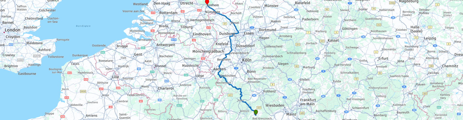
 This route starts in Kirchberg at Landhotel Karrenberg. Via wonderfully winding roads where it is pleasant to steer you will pass beautiful places that the Eifel has to offer.
After having enjoyed the beautiful Eifel for more than 200 kilometers, the route continues on the highway to eventually end in Arnhem at the Postiljon Hotel along the A12. From here you can then continue the road to your final destination. Of course it is also possible to leave the route at an earlier moment in order to enter the Netherlands further south.
 Share this route


Animation

Verdict


Duration
10h 16m

Mode of travel
Car or motorcycle

Distance
406.43 km

Countries


 RouteXpert Review
 The first part of this route winds through these beautiful surroundings. After more than 200 kilometers you continue on the motorway, because you end up in the Ruhr area. There is no fun 'driving through the house': Busy traffic, many traffic lights and a lot of buildings.
A route in the beautiful surroundings of the Eifel normally earns 4 stars with ease, but since the last part is on the highway with a view of the Ruhr area, my final judgment is 3 stars.
The route starts at Landhotel Karrenberg in Kirchberg. A beautifully situated hotel surrounded by greenery. Just after you have left the parking lot of the hotel you will immediately get a few nice bends for the wheels on the road with number K3. This is roughly what you can expect the first half of this route, especially many beautiful curves. The fact that you also have a pleasant view from those bends is a bonus.
At Senheim you arrive at the Moselle, a river in France, Luxembourg and Germany. Via the Our and the Sûre waters divide Belgium into the Moselle and Rhine. The Moselle has its source at the Col de Bussang in the Vosges at an altitude of 735 meters and flows into the Rhine at Koblenz after 544 kilometers.
After the crossing of the Moselle, after about 500 meters there is a small parking lot where you can stop for a few nice pictures and of course enjoy the many boats that come from the marina on the other side.
The route winds further north through the wooded rolling landscape in which the roads are beautifully constructed. No wonder it is a favorite area for motorcyclists here.
Another favorite place in the Eifel is the Nürburgring. Of course not only for motorcyclists, many motorists also blow their rounds on this almost 21 kilometer long circuit. Driving your own car or motorcycle over the Nordschleife of the Nürburgring is a special challenge. Mastering the 20.8 km route means that you have to reassess your driving skills and yourself under the toughest conditions. It may be clear that unfortunately things regularly go wrong, there are plenty of videos of this on YouTube.
Just after Müllenbach you can turn right to visit the circuit. What immediately stands out is the roller coaster protruding high above the building. At least it seems.
At the beginning of the 21st century there were big plans for the circuit. For example, there had to be the fastest roller coaster in the world to allow visitors to experience what it is like to experience the acceleration of an F1 car. From 0 to 217 kilometers per hour in a few seconds. The whole roller coaster was focused on launch and top speed. After the start there were some turns and then stopped on a straight piece. There, complete with starting lights, an F1 start was simulated.
The opening was postponed several times due to many technical problems. In the end, the roller coaster was opened by none other than Michael Schumacher four years later than planned. However, due to the problems they still had to deal with, the top speed was greatly reduced, from 217 to 160 kilometers per hour.
Unfortunately, this rollercoaster cost so much money that it eventually led to the bankruptcy of the Nürburgring, already in 2012. In 2014, however, a new owner was found who, since 2015, has the philosophy that the Nürburgring should limit itself to the core activities, the car and motorsport. The roller coaster is not one of them. It is decided to tear it down.
Ten years after construction, however, the construction has been given a new purpose. In the spiral of Ring Racer, which is 37.5 meters high, lamps are mounted to light the adjacent Hotel Lindner. According to a spokesperson for the circuit, the lighting provides an atmospheric image in the evening. An expensive atmospheric image if you ask me ...
After your visit to the Nürburgring, you wind through a beautiful stretch between the Nordschleife towards Adenau. A coffee stop is planned there at Cockpit am Nürburgring. Another fun thing to do is to walk up the stairs on the other side of the road right next to the viaduct. You look out over the circuit, with a bit of luck you will drive and you can see how things are going.
Further on you come to Heimbach past the viewpoint Henriette Platz. This point gives you a great view of the area. Always nice for a photo.
Not much further you will pass the viewpoint Schöne Aussicht. For this you have to leave the route for a while, but it gives you a beautiful view over the Rurtalsperre, a dam in the Rur near the German town of Heimbach. This dam was built to regulate the water level in the lower reaches of the Rur and to generate electricity by means of a hydroelectric power station. The dam was built between 1934 and 1938. In 1939 it was put into use. The dam is made of stones and soil, with loam in between.
Towards the end of World War II, the Rur was in the front line between the German and Allied forces. The German troops sabotaged the valves of the dam, so that the reservoir emptied. This caused high water downstream in the Rur, causing the Allied Operation Grenade to be delayed by two weeks. Between 1955 and 1959 the dam was raised by 20 meters to the current 77 meters above the old river bed.
A few kilometers further you arrive, after first having enjoyed lunch, at the second, much more boring part of this route: The highway to Arnhem. Not an interesting part through the Ruhr area. Busy, drab, gray. Reason to do this via the highway, then you will get through it quickly. In my opinion, the inside door is not an issue here. You drive from one town into another, often with lots of traffic lights and correspondingly heavy traffic.
On the way there are still two stops for a cup of coffee or another snack. Via the A44, A46, A57, A40 and A3 you will eventually reach Babberich and Zevenaar in the Netherlands. A few kilometers further along the A12 you will reach the end of this route, the Postiljon hotel near Arnhem. From there you can plan your own route to your final destination.
Have fun driving this route!


 Links
Links  Usage
Usage Want to download this route?
You can download the route for free without MyRoute-app account. To do so, open the route and click 'save as'. Want to edit this route?
No problem, start by opening the route. Follow the tutorial and create your personal MyRoute-app account. After registration, your trial starts automatically.  Disclaimer
Use of this GPS route is at your own expense and risk. The route has been carefully composed and checked by a MyRoute-app accredited RouteXpert for use on TomTom, Garmin and MyRoute-app Navigation.
Changes may nevertheless have occurred due to changed circumstances, road diversions or seasonal closures. We therefore recommend checking each route before use.
Preferably use the route track in your navigation system. More information about the use of MyRoute-app can be found on the website under 'Community' or 'Academy'.

North Rhine-Westphalia
About this region
North Rhine-Westphalia (German: Nordrhein-Westfalen, pronounced [ˌnɔʁtʁaɪn vɛstˈfaːlən] (listen); Low Franconian: Noordrien-Wesfale; Low German: Noordrhien-Westfalen; Colognian: Noodrhing-Wäßßfaale), commonly shortened to NRW (German: [ɛnʔɛʁˈveː] (listen)), is a German state (Land) in Western Germany. With more than 17.9 million inhabitants, it is the most populous state of Germany. Covering an area of 34,084 square kilometres (13,160 sq mi), it is the fourth-largest German state by size. Apart from the city-states, it is also the most densely populated state in Germany.
North Rhine-Westphalia features 30 of the 81 German municipalities with over 100,000 inhabitants, including Cologne (over 1 million), the state capital Düsseldorf, Dortmund and Essen (all about 600,000 inhabitants) and other cities predominantly located in the Rhine-Ruhr metropolitan area, the largest urban area in Germany and the third-largest on the European continent. The location of the Rhine-Ruhr at the heart of the European Blue Banana makes it well connected to other major European cities and metropolitan areas like the Randstad, the Flemish Diamond and the Frankfurt Rhine-Main Region.
North Rhine-Westphalia was established in 1946 after World War II from the Prussian provinces of Westphalia and the northern part of Rhine Province (North Rhine), and the Free State of Lippe by the British military administration in Allied-occupied Germany and became a state of the Federal Republic of Germany in 1949. The city of Bonn served as the federal capital until the reunification of Germany in 1990 and as the seat of government until 1999.
Culturally, North Rhine-Westphalia is not a uniform area; there are significant differences, especially in traditional customs, between the Rhineland region on the one hand and the regions of Westphalia and Lippe on the other. The state has always been Germany's powerhouse with the largest economy among the German states by GDP figures.
Read more on Wikipedia
North Rhine-Westphalia features 30 of the 81 German municipalities with over 100,000 inhabitants, including Cologne (over 1 million), the state capital Düsseldorf, Dortmund and Essen (all about 600,000 inhabitants) and other cities predominantly located in the Rhine-Ruhr metropolitan area, the largest urban area in Germany and the third-largest on the European continent. The location of the Rhine-Ruhr at the heart of the European Blue Banana makes it well connected to other major European cities and metropolitan areas like the Randstad, the Flemish Diamond and the Frankfurt Rhine-Main Region.
North Rhine-Westphalia was established in 1946 after World War II from the Prussian provinces of Westphalia and the northern part of Rhine Province (North Rhine), and the Free State of Lippe by the British military administration in Allied-occupied Germany and became a state of the Federal Republic of Germany in 1949. The city of Bonn served as the federal capital until the reunification of Germany in 1990 and as the seat of government until 1999.
Culturally, North Rhine-Westphalia is not a uniform area; there are significant differences, especially in traditional customs, between the Rhineland region on the one hand and the regions of Westphalia and Lippe on the other. The state has always been Germany's powerhouse with the largest economy among the German states by GDP figures.
View region
 Statistics
  140
140Amount of RX reviews (North Rhine-Westphalia)
 79271
79271Amount of visitors (North Rhine-Westphalia)
 34156
34156Amount of downloads (North Rhine-Westphalia)
 Route Collections in this region
 The 10 most beautiful car and motorcycle routes in Limburg
Limburg, who thinks of Limburg, thinks of flan, coal mines, marl and the hill country. The coal mines have been closed for almost 40 years, the last load of coal was brought up from the Oranje-Nassau coal mine in Heerlen on 31 December and, as they say, South Limburg was transformed from Black to Green and unfortunately there is still little left. view of this period.
But not only pie, marl and coal in Limburg, but also a very beautiful province to tour by car or motorcycle and enjoy all the beauty that the province of Limburg has to offer. For this, the MyRoute app RouteXpert has put together a Top 10 of Car and Motorcycle routes for you.
All routes in this collection have been checked and made equal for TomTom, Garmin and MyRoute-app Navigation by a MyRoute-app RouteXpert.
If you think, I have a very nice route that should certainly not be missing from this collection, send it to:
email: routeexpert@myrouteapp.com
Subject: New Route for the Top 10 collection Province of Limburg composed by Hans van de Ven.
The route will then be reviewed and then added to the Top 10.
To make the Top 10 also the Top 10, 1 route will have to disappear from the Top 10, you can indicate this when submitting the new route.
Have fun with this collection and while driving one of these routes. Enjoy all the beauty that the Netherlands and in particular the province of Limburg has to offer. Click on “View route” to read the review of the chosen route.
I would like to hear your findings about the route(s).
View Route Collection
Top 5 Car and Motorcycle Routes in the Eifel
The Eifel is the eastern part of the medium plateau Eifel-Ardennes. It is located north of the Moselle and west of the Rhine. The largest part is in Germany, a small part is in Belgium, in the East Cantons. The German part of Eifel is located in the federal states of North Rhine-Westphalia and Rhineland-Palatinate. The highest point is the Hohe Acht with 747 meters.
Several chains can be distinguished in the Eifel:
The northernmost part is called the Nordeifel, which in Belgium connects to the High Fens;
To the east of this is the Ahrgebirge, this part is located north of the Ahr in the Ahrweiler district;
South of the Ahr is the Hohe Eifel (or Hocheifel), of which the Hohe Acht (747 m) is the highest point, and also the highest point in the entire Eifel region;
To the west, near the Belgian border, the hills are known as Schneifel, part of the wider Snow Eifel area with peaks reaching up to 698 metres;
South and east of the Hohe Eifel is the Volcano-Eifel, a volcanic area with many crater lakes (Maare).
The southern part of the Eifel is less high. The area is bisected by streams and rivers running southwards. These streams flow into the Moselle. The largest of these rivers is the Kyll; the hills around this river are known as the Kyllwald;
In the south, the Eifel ends in the Voreifel.
In the north of the Eifel there are some large reservoirs. The largest of these is the reservoir in the Roer that was created by the construction of the Roerdal dam.
The Nürburgring is also located in the Eifel, a well-known car circuit for Formula 1 races, among other things. Since 2004, part of the north of the Eifel has become the Eifel National Park. This National Park falls entirely within the German-Belgian nature park High Fens-Eifel. Another part of the Eifel falls within the South Eifel Nature Park.
Well-known throughout the Netherlands and Belgium by car and motorcyclists, so reason enough for the MyRoute app RouteXpert to compile a Top 5 of Car and Motorbike routes for you.
All routes in this collection have been checked and made equal for TomTom, Garmin and MyRoute-app Navigation by a MyRoute-app RouteXpert.
If you think, I have a very nice route that should certainly not be missing from this collection, send it to:
email: routeexpert@myrouteapp.com
Subject: New Route for the Top 5 collection Eifel composed by Hans van de Ven.
The route will then be reviewed and then added to the Top 5. To make the Top 5 also the Top 5, 1 route will have to disappear from the Top 5, you can indicate this when submitting the new route.
Have fun with this collection and while driving one of these routes. Enjoy all the beauty that the Eifel has to offer. Click on “View route” to read the review of the chosen route.
I would like to hear your findings about the route(s).
View Route Collection