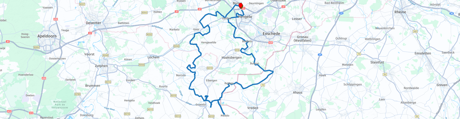
TTT 2018 01 Rondje Achterhoek vanuit Hengelo

This route was brought to you by:
RouteXpert Hans van de Ven (Mr.MRA)
Last edit: 16-05-2020
 Route Summary
 This TTT are touring through the Netherlands with the occasional trip to Belgium, Germany or even Luxembourg, which are driven 6 to 7 times a year. The 1st around March and the last around October. These TTTs have a starting point, a pause location and an end point. It is nice to discover what you have not seen in your own country and which nice roads you did not know before.
This TTT is from 2018, so the route may differ slightly from the original.
I have checked all route points and, where necessary, placed them neatly on the road. Also, if necessary, I have further set the starting point and end point of the route a little further apart to prevent navigation to the end point directly and added the POI files of the start and end point, as well as possible pause location (s).
Finally, I made the route the same for TomTom, Garmin and MRA Navigation users.
Thanks to Promoter.
 Share this route


Animation

Verdict


Duration
4h 4m

Mode of travel
Car or motorcycle

Distance
141.47 km

Countries


 RouteXpert Review
 A varied green route along grassy meadows, winding streams, timeless ponds and dark forests. In De Achterhoek you enjoy as a motorcyclist the geographical embrace between beautiful nature and unpolished agricultural landscape. In the spring, the full scents stimulate your senses, while many a meadow bird cheering in the spring.
After the start in Hengelo, the narrow roads that run through the beautiful meadow landscape follow relatively quickly. The area is completely unpleasant, mainly due to the lack of a maze of traffic lights, traffic signs and thresholds. The rural character of the Achterhoek caters to the pure enjoyment of people and motorbikes. Imagine what that should be like when it's spring. When the cattle ruminates on juicy grass, birds of prey circling alert in the zwerk and lapwing showy antics. Spring in the Achterhoek, that is really something to look forward to.
The ride takes you past many characteristic farms, some of which have stood the test of time with difficulty. Cuddly decay, which also characterizes the route's sjeu. Dull paint on crooked barn doors or rusty agricultural equipment far away in a meadow looks nostalgic. Lack of maintenance deserves a friendly nod in De Achterhoek.
Until the mid-20th century, De Achterhoek (also known as De Graafschap) was important for the substantial logging. Nevertheless, the rugged area was considered a corner for centuries and was therefore hardly cultivated. Both socially and geographically. And especially from the latter you get your driving pleasure today, reinforced by the idea of not being constantly monitored. Especially when you start early, when the region slowly awakens, you experience a great deal of freedom through the landscape.
In many picturesque ponds, herons are spying on a tasty meal. No hurry seems obvious. The Achterhoek asks for it. With an adjusted speed you can also explore the area from the saddle well. After all, the route hardly ever touches village centers or busy areas. The landscape is rustic and you have all the time.
For a moment you cross the border with Germany and you pass the tiny German Oldenkott. Then you cross the meandering river Berkel to the Huttendijk in the Netherlands. The differences in height between road and pasture betray an old landscape. Fields that were cultivated by many generations of peasant families slowly increased in size, like annual rings of an age-old tree. The roads along the many groves also invite you to take a break every now and then. The pleasant air from early spring will soon stimulate your lungs. The signposts and farms covered with moss contribute to the timeless character of this beautiful region. And you understand better and better why De Achterhoek is a beloved environment to go through quietly. Great for the awakening motorcyclist, who can also sharpen his or her driving skills during a first fresh spring ride.
The pleasant TankTasTocht winds among other things along the village of Meddo. At Lichtenvoorde you reach the southernmost and also furthest point of the route, which still guides you around many built-up areas. Therefore, from the corner of your eye, take a little account of small crossing or uninhibited game. Mating behavior makes animals - just like motorcyclists on their first ride - somewhat blind. If you look into one of the many forest paths at right angles to the road, it may just happen that there is a watchful deer in the middle. Roodwild was once a popular trophy of the local large landowners. Many four-legged friends ended with a hook on the wall. We continue, past the pale green meadows where the dandelions will soon stand out. Then the hares are skittish. Given the driving pace and the nature of the route, there is ample time to observe all this from the saddle.
Along the way you can refuel that it is a sweet delight. 'Eat and drink! The local dialect of the service is inextricably on the De Achterhoek menu. Don't forget to bring a camera. The sunlight through the trees along the many winding roads produces very beautiful light harps. And the few shards of fog also do wonders. So above all enjoy the photogenic grits that still have to grow considerably in horsepower. Via the Zegendijk the route winds along Beltrum, Haarlo, Noordijk to Sint Isidorushoeve, the church tower of which is clearly visible from afar. Most likely it is now high time for a coffee break. With a traditional Achterkoek or apple pie.
The last tens of kilometers of the TankTasTocht once again take you through a brash landscape and therefore deserve just as much attention. Because here too, the region is still showing its best side. Via the Geessinkweg you finally enter Enschede again. The first TankTasTocht is finished: The Achterhoek has fulfilled its honest promise. (Source: Promotor 02-2018)
Because I have driven this route myself, this route gets 5 stars.


 Links
Links  Usage
Usage Want to download this route?
You can download the route for free without MyRoute-app account. To do so, open the route and click 'save as'. Want to edit this route?
No problem, start by opening the route. Follow the tutorial and create your personal MyRoute-app account. After registration, your trial starts automatically.  Disclaimer
Use of this GPS route is at your own expense and risk. The route has been carefully composed and checked by a MyRoute-app accredited RouteXpert for use on TomTom, Garmin and MyRoute-app Navigation.
Changes may nevertheless have occurred due to changed circumstances, road diversions or seasonal closures. We therefore recommend checking each route before use.
Preferably use the route track in your navigation system. More information about the use of MyRoute-app can be found on the website under 'Community' or 'Academy'.

North Rhine-Westphalia
About this region
North Rhine-Westphalia (German: Nordrhein-Westfalen, pronounced [ˌnɔʁtʁaɪn vɛstˈfaːlən] (listen); Low Franconian: Noordrien-Wesfale; Low German: Noordrhien-Westfalen; Colognian: Noodrhing-Wäßßfaale), commonly shortened to NRW (German: [ɛnʔɛʁˈveː] (listen)), is a German state (Land) in Western Germany. With more than 17.9 million inhabitants, it is the most populous state of Germany. Covering an area of 34,084 square kilometres (13,160 sq mi), it is the fourth-largest German state by size. Apart from the city-states, it is also the most densely populated state in Germany.
North Rhine-Westphalia features 30 of the 81 German municipalities with over 100,000 inhabitants, including Cologne (over 1 million), the state capital Düsseldorf, Dortmund and Essen (all about 600,000 inhabitants) and other cities predominantly located in the Rhine-Ruhr metropolitan area, the largest urban area in Germany and the third-largest on the European continent. The location of the Rhine-Ruhr at the heart of the European Blue Banana makes it well connected to other major European cities and metropolitan areas like the Randstad, the Flemish Diamond and the Frankfurt Rhine-Main Region.
North Rhine-Westphalia was established in 1946 after World War II from the Prussian provinces of Westphalia and the northern part of Rhine Province (North Rhine), and the Free State of Lippe by the British military administration in Allied-occupied Germany and became a state of the Federal Republic of Germany in 1949. The city of Bonn served as the federal capital until the reunification of Germany in 1990 and as the seat of government until 1999.
Culturally, North Rhine-Westphalia is not a uniform area; there are significant differences, especially in traditional customs, between the Rhineland region on the one hand and the regions of Westphalia and Lippe on the other. The state has always been Germany's powerhouse with the largest economy among the German states by GDP figures.
Read more on Wikipedia
North Rhine-Westphalia features 30 of the 81 German municipalities with over 100,000 inhabitants, including Cologne (over 1 million), the state capital Düsseldorf, Dortmund and Essen (all about 600,000 inhabitants) and other cities predominantly located in the Rhine-Ruhr metropolitan area, the largest urban area in Germany and the third-largest on the European continent. The location of the Rhine-Ruhr at the heart of the European Blue Banana makes it well connected to other major European cities and metropolitan areas like the Randstad, the Flemish Diamond and the Frankfurt Rhine-Main Region.
North Rhine-Westphalia was established in 1946 after World War II from the Prussian provinces of Westphalia and the northern part of Rhine Province (North Rhine), and the Free State of Lippe by the British military administration in Allied-occupied Germany and became a state of the Federal Republic of Germany in 1949. The city of Bonn served as the federal capital until the reunification of Germany in 1990 and as the seat of government until 1999.
Culturally, North Rhine-Westphalia is not a uniform area; there are significant differences, especially in traditional customs, between the Rhineland region on the one hand and the regions of Westphalia and Lippe on the other. The state has always been Germany's powerhouse with the largest economy among the German states by GDP figures.
View region
 Statistics
  138
138Amount of RX reviews (North Rhine-Westphalia)
 73855
73855Amount of visitors (North Rhine-Westphalia)
 31755
31755Amount of downloads (North Rhine-Westphalia)
 Route Collections in this region
 The 10 most beautiful car and motorcycle routes in Limburg
Limburg, who thinks of Limburg, thinks of flan, coal mines, marl and the hill country. The coal mines have been closed for almost 40 years, the last load of coal was brought up from the Oranje-Nassau coal mine in Heerlen on 31 December and, as they say, South Limburg was transformed from Black to Green and unfortunately there is still little left. view of this period.
But not only pie, marl and coal in Limburg, but also a very beautiful province to tour by car or motorcycle and enjoy all the beauty that the province of Limburg has to offer. For this, the MyRoute app RouteXpert has put together a Top 10 of Car and Motorcycle routes for you.
All routes in this collection have been checked and made equal for TomTom, Garmin and MyRoute-app Navigation by a MyRoute-app RouteXpert.
If you think, I have a very nice route that should certainly not be missing from this collection, send it to:
email: routeexpert@myrouteapp.com
Subject: New Route for the Top 10 collection Province of Limburg composed by Hans van de Ven.
The route will then be reviewed and then added to the Top 10.
To make the Top 10 also the Top 10, 1 route will have to disappear from the Top 10, you can indicate this when submitting the new route.
Have fun with this collection and while driving one of these routes. Enjoy all the beauty that the Netherlands and in particular the province of Limburg has to offer. Click on “View route” to read the review of the chosen route.
I would like to hear your findings about the route(s).
View Route Collection
Top 5 Car and Motorcycle Routes in the Eifel
The Eifel is the eastern part of the medium plateau Eifel-Ardennes. It is located north of the Moselle and west of the Rhine. The largest part is in Germany, a small part is in Belgium, in the East Cantons. The German part of Eifel is located in the federal states of North Rhine-Westphalia and Rhineland-Palatinate. The highest point is the Hohe Acht with 747 meters.
Several chains can be distinguished in the Eifel:
The northernmost part is called the Nordeifel, which in Belgium connects to the High Fens;
To the east of this is the Ahrgebirge, this part is located north of the Ahr in the Ahrweiler district;
South of the Ahr is the Hohe Eifel (or Hocheifel), of which the Hohe Acht (747 m) is the highest point, and also the highest point in the entire Eifel region;
To the west, near the Belgian border, the hills are known as Schneifel, part of the wider Snow Eifel area with peaks reaching up to 698 metres;
South and east of the Hohe Eifel is the Volcano-Eifel, a volcanic area with many crater lakes (Maare).
The southern part of the Eifel is less high. The area is bisected by streams and rivers running southwards. These streams flow into the Moselle. The largest of these rivers is the Kyll; the hills around this river are known as the Kyllwald;
In the south, the Eifel ends in the Voreifel.
In the north of the Eifel there are some large reservoirs. The largest of these is the reservoir in the Roer that was created by the construction of the Roerdal dam.
The Nürburgring is also located in the Eifel, a well-known car circuit for Formula 1 races, among other things. Since 2004, part of the north of the Eifel has become the Eifel National Park. This National Park falls entirely within the German-Belgian nature park High Fens-Eifel. Another part of the Eifel falls within the South Eifel Nature Park.
Well-known throughout the Netherlands and Belgium by car and motorcyclists, so reason enough for the MyRoute app RouteXpert to compile a Top 5 of Car and Motorbike routes for you.
All routes in this collection have been checked and made equal for TomTom, Garmin and MyRoute-app Navigation by a MyRoute-app RouteXpert.
If you think, I have a very nice route that should certainly not be missing from this collection, send it to:
email: routeexpert@myrouteapp.com
Subject: New Route for the Top 5 collection Eifel composed by Hans van de Ven.
The route will then be reviewed and then added to the Top 5. To make the Top 5 also the Top 5, 1 route will have to disappear from the Top 5, you can indicate this when submitting the new route.
Have fun with this collection and while driving one of these routes. Enjoy all the beauty that the Eifel has to offer. Click on “View route” to read the review of the chosen route.
I would like to hear your findings about the route(s).
View Route Collection