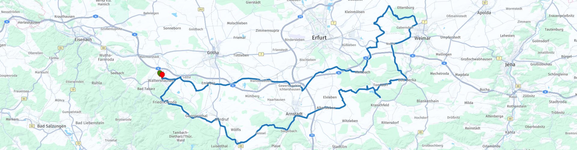
Roundtrip from Waltershausen to the Buchenwald Memorial

This route was brought to you by:
RouteXpert Catherine De Groote RouteXpert
Last edit: 26-10-2023
 Route Summary
 The towns are often small, but particularly beautiful because of their beautiful architecture. Nature is very varied and special. The vast nature with mountains, river valleys, reservoirs and vast forests is impressive. Who wouldn't want to tour such a beautiful landscape?! The best part is that this region has not yet been discovered en masse.
During this ride we delve into history. You will pass, among other things, the armistice carriage 'Wagon van Compiègne'. The original carriage was destroyed here in Crawinkel. We also stop at the Hohenfelden Open Air Museum with its typical half-timbered houses. Impressive is of course the Buchenwald concentration camp, which is located about halfway along this journey. In between, authentic villages and towns await us. Like everywhere in Thuringia, you are now treated to some beautiful views. There is certainly no shortage of beautiful roads. This route gets 5 stars.
 Share this route


Animation

Verdict


Duration
9h 4m

Mode of travel
Car or motorcycle

Distance
180.64 km

Countries

 RouteXpert Review
 There is a petrol station 500 m away. You can refuel at both the start and the end of the ride.
In the next village of Wahlwinkel you have to turn right towards Friedrichsroda.
Sankt Trinitatis Dreifaltigkeitskirche in Gräfenhain was completed in 1728. It received its first major reconstruction between 1986 and 1991. The interior of the church was particularly beautifully decorated in the Baroque courtly atmosphere. The ceiling and gallery frescoes were exposed again after being painted over at the end of the 19th century and once again show their original splendor.
Just before Crawinkel you leave the main road to stop at the 'Wagen von Compiègne'.
The monument commemorates the Compiègne wagon in which the 1918 armistice was sealed. Towards the end of World War II it was destroyed here in the forest.
A memorial stone with plaque, a piece of rail with a bump stop and an information board provide information about the route and the end of the carriage in the forest near Crawinkel.
Arnstadt is located on the Gera and is one of the five so-called Thuringian 'Bach cities'. It is also the oldest city in Thuringia. At the end of the Second World War, Arnstadt suffered heavily from bombing and shelling. On April 10, 1945, Arnstadt was occupied by the Americans and the administration was transferred to the Russians at the beginning of July. In 1949 the city ended up in the GDR.
Roses Café Bistro is a cozy café where you can enjoy a small snack or cake with coffee or hot chocolate. There is a wide variety of different coffee and tea specialties.
The more than 30 houses in the Hohenfelden open-air museum come from different times and regions of the Free State of Thuringia and are historically unique and authentically furnished. In addition to large and small houses, a rare half-timbered house and a flower pottery, you will also find Thuringia's oldest windmill on the museum grounds.
Restaurant Bella Vista is an Italian/German restaurant located on the beautiful shore of the Hohenfelden reservoir. Where nature invites you to dream and water meets land, culinary delicacies are served here. When the weather is nice, the outdoor terrace invites you to linger in the sun. You can also enjoy the panoramic view of the reservoir indoors.
Bad Berka is a spa town with an iron-rich spring. A clinic was built in 1952 to treat tuberculosis. This was the beginning of the city's most important economic sector. Bad Berka's Zentralklinik has since built a reputation as a center of medicinal expertise far beyond the borders of Germany. Its founding dates back to 1898. In addition, a rehabilitation clinic was built after the fall of the Berlin Wall.
Due to its proximity to the cultural capital Weimar and its association with numerous historical figures, Bad Berka is also popular among tourists. Between 1812 and 1828 Goethe visited his friend Heinrich Friedrich Schütz several times. He was also involved in the plans of the spa. That is why Bad Berka is also called 'Das Goethebad im Grünen'. After all, Bad Berka is surrounded by spruce and beech forests.
From Weimar, the Ettersburg Strasse leads to Buchenwald. The Bloedstraat, built by the prisoners, begins about two kilometers outside the built-up area. The road is partly still in its original state. About three kilometers further is the memorial with the enormous clock tower, the Street of Nations (with the mention of the nationalities who died in the camp) and the group of statues depicting the resistance in Buchenwald. This memorial can be seen from far and wide and serves as a warning to prevent what happened from happening again. The densely vegetated area nearby used to be home to the SS garages and the Gustloff Weapons Factory II. You then pass the former Buchenwald station, where thousands of prisoners arrived from March 1943.
The stretch of road between the station and the entrance gate was and is called the Carachoweg. The camp security was located here. Of these, the gas station, garages and the remains of the headquarters are still visible. The parking lot and bus stop are located on the former SS training grounds. Part of the barracks is now used as a cafeteria and information center.
The concentration camp itself has largely been demolished, despite strong protests from the former prisoners. The camp gate with the bunker has been preserved together with some watchtowers. The crematorium is also still there. The former clothing warehouse/storage depot now houses an impressive permanent exhibition. All aspects of KZ Buchenwald are covered in detail in good accompanying texts. Many gruesome objects (e.g. the lampshade made of human skin) can be seen there. There is an equally well-constructed exhibition about the Soviet internment camp. All this is definitely worth a visit. Entrance is free.
You have reached the furthest point of this tour. The return route is largely through open terrain along secondary roads that wind around and over the motorway.
The Lapidarium Willrode is a collection of historic boundary and district stones on the grounds of the Willroda ranger hut near the Thuringian capital Erfurt.
An exhibition of Thuringian boundary stones has been set up on the western courtyard side of the building since 2009. There are approximately thirteen boundary and district stones here with well-labeled explanation boards. The collection presents the demarcations of the outer borders of historic sovereign areas. Initials on the heads of the stones or their coat of arms indicate the respective rulership. For example, 'KP' stands for the Kingdom of Prussia, while 'HG' refers to the Duchy of (Saxony-)Gotha. Other district stones contain the initials of the district or the consecutive numbering.
The building complex now called Forsthaus Willroda (also Willrode) and included in the list of castles and palaces in Thuringia, is located in the Willroda Forest. The Willroda ranger's hut consists of several buildings that were built as a fortified estate and later converted and expanded into a hunting lodge and then a ranger's hut.
There are not many options for a drink. But in Gaststätte Roter Hirsch you can certainly enjoy a snack and a drink. There is also a nice large terrace.
In Schwabhausen you will pass a gas station, but you can of course also wait at the gas station close to the holiday home.
This was a well-filled day with the visit to the Hohenfelden Open Air Museum and Buchenwald.


 Links
Links  Usage
Usage Want to download this route?
You can download the route for free without MyRoute-app account. To do so, open the route and click 'save as'. Want to edit this route?
No problem, start by opening the route. Follow the tutorial and create your personal MyRoute-app account. After registration, your trial starts automatically.  Disclaimer
Use of this GPS route is at your own expense and risk. The route has been carefully composed and checked by a MyRoute-app accredited RouteXpert for use on TomTom, Garmin and MyRoute-app Navigation.
Changes may nevertheless have occurred due to changed circumstances, road diversions or seasonal closures. We therefore recommend checking each route before use.
Preferably use the route track in your navigation system. More information about the use of MyRoute-app can be found on the website under 'Community' or 'Academy'.