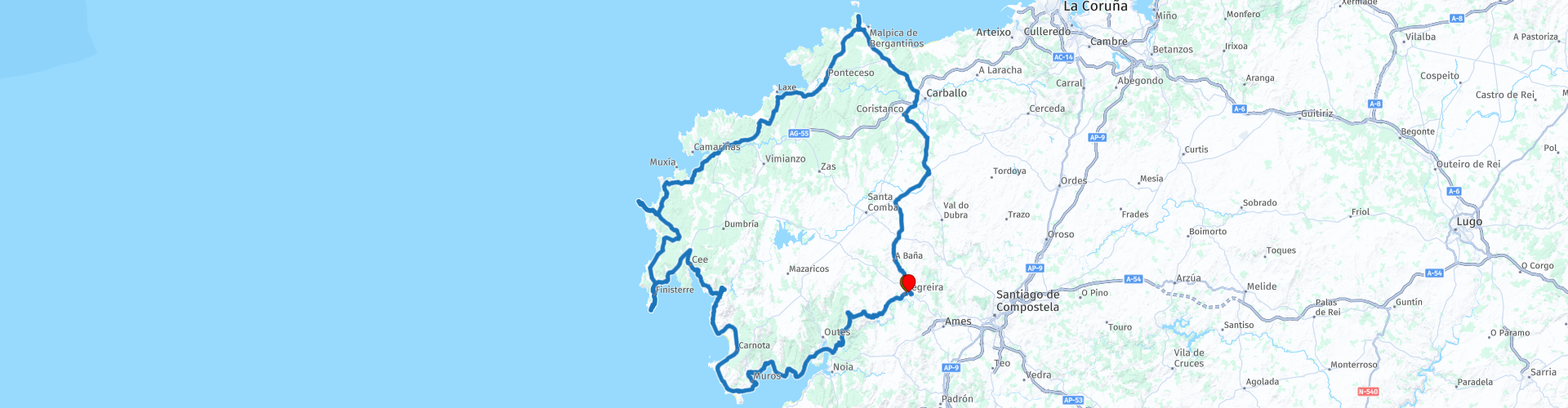
Round trip from Negreira visiting Cape Finisterre Cape Tourinan and Muxía

This route was brought to you by:
RouteXpert Nick Carthew - (MRA Master)
Last edit: 31-07-2025
 Route Summary
 I have awarded this route with 4 stars**** The roads are good and the scenery and attractions are very good.
 Share this route


Animation

Verdict


Duration
6h 48m

Mode of travel
Car or motorcycle

Distance
213.59 km

Countries

 RouteXpert Review
 A paradise surrounded by rivers and lush forests where Roman history and architecture are still present. Just a few kilometres from Santiago de Compostela, it is a stopover for pilgrims traveling to Santiago along the Maritime Way or those who decide to follow the route to reach the End of the World in Finisterre.
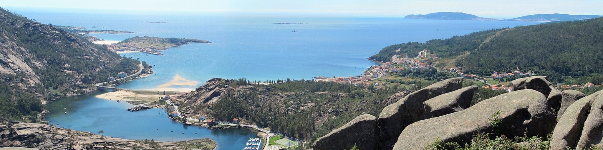
Costa de la Muerte; "Death Coast". Rocky headlands, winding inlets, small fishing towns, plunging cliffs, wide sweeping bays and many a remote, sandy beach – this is the eerily beautiful 'Coast of Death'.
The route heads out of Negreira and travels towards the spectacular coastline that this area is known for by following the DP-5602. This road is surfaced along it's entire length but is very narrow in places as you pass through the forested areas. It has a feeling of a forest trail in places as the trees are so close and the road so narrow, very enjoyable though.
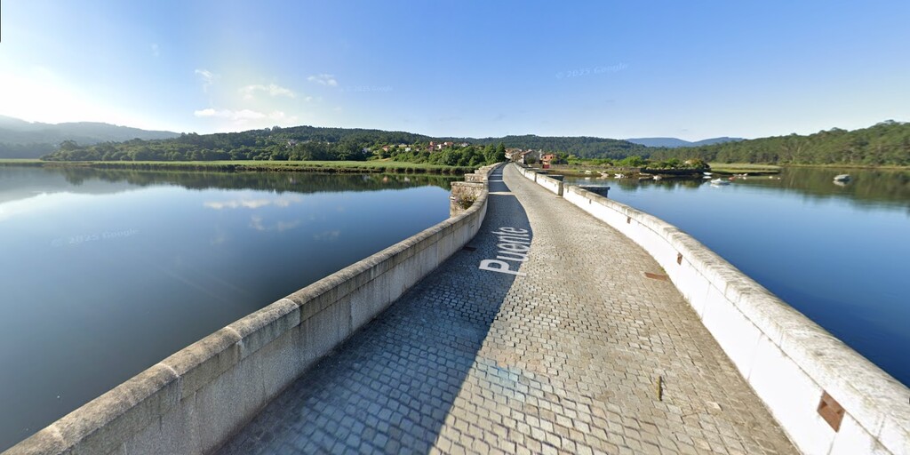
The route reaches the Tambre River and uses a bridge that was called “Ponte das Pías” in medieval documents. It crosses the Tambre River and links the municipalities of Outes and Noia, serving as the border between the two. Before it was built, people had to cross the estuary by boat. It owes its present-day appearance to medieval modifications and the reconstruction that was carried out between 1842 and 1844. The cobblestone surface makes it more attractive.
The route crosses over the Tambre river two more times, the last time using the Ponte do Langaño bridge then you'll
follow the coastline passing through the harbour town of Muros where you will see the Rebordiño Lighthouse situated at the southern entrance to the town it is declared a Site of Special Historic-Artistic Interest and dates back to 1909.
A short distance from the lighthouse there is a layby where you can stop for a photo of great views across the estuary Ría de Muros e Noia towards Porto do Son and beyond.
There are many viewpoints to stop for photo's and a particularly good one is the Miradoiro do Ézaro viewpoint which has a magnificent vista of the mouth of the Rio Xallas, the granite slopes of Mount Pindo, the cove of O Ézaro, the small Lobeiras islands and the unmistakable shape of Cape Finisterre in the background.
The route now heads for Cape Finisterre which for some on the Santiago de Compostela pilgrimage is their end point.
Cape Finisterre, known as Spain’s Land’s End, is where the Camino de Santiago truly reaches its conclusion.
Its name, Finis-terrae—“the end of the earth”—was bestowed by the Romans, who believed this was the edge of the known world. Here, they performed nightly sacrifices to ensure the Sun’s safe return each morning.
This coastline is known as Costa da Morte (Coast of Death) as it is one of the most dangerous coastlines in Europe. Over the centuries, its treacherous waters caused many shipwrecks, claiming the lives of countless sailors. Towering waves crash violently against the cliffs, creating an intense and dramatic landscape. It’s easy to understand why this place feels both awe-inspiring and eerie.
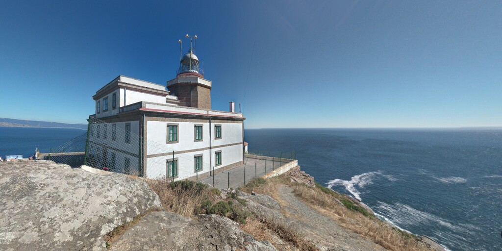
The legendary Lighthouse of Finisterre was constructed in the year of 1853 at the tip of Cape Finisterre. When the skies are clear and the sun is shining brightly, one can enjoy the view of the famous Galician lighthouse from up to 30 kilometres out at sea. The lighthouse is a reminder of numerous marine battles that occurred between the French and English around the cape.
A little further up the coast is Cape Touriñan, the most western point in Spain and another lighthouse, well two actually. The first lighthouse at Touriñán, was completed in 1898, and consists of a single storey keeper's house with the tower centrally located at the apex of the roof. A new lighthouse, which was built adjacent to the original building first entered service in 1981. It consists of a 11m high cylinder-shaped tower, that supports twin galleries and a lantern with a grey cupola.
A short 30 minute ride from here takes you to Muxia, a small town with a little more than 5,000 inhabitants found on the Costa da Morte in the province of A Coruña. The main attraction of this seafaring village is its coast, from which you can observe the fierceness of the Atlantic Ocean. However, that’s not the only draw, since eating in Muxia is also a pleasure. If you love seafood, you can’t miss eating in Muxia so I have suggested a lunch stop here.
After lunch the route heads back to the start point at Negreira, a gentle ride taking approximately 45 minutes, so you can indulge yourself to a slap-up meal.
Enjoy
 Links
Links  Usage
Usage Want to download this route?
You can download the route for free without MyRoute-app account. To do so, open the route and click 'save as'. Want to edit this route?
No problem, start by opening the route. Follow the tutorial and create your personal MyRoute-app account. After registration, your trial starts automatically.  Disclaimer
Use of this GPS route is at your own expense and risk. The route has been carefully composed and checked by a MyRoute-app accredited RouteXpert for use on TomTom, Garmin and MyRoute-app Navigation.
Changes may nevertheless have occurred due to changed circumstances, road diversions or seasonal closures. We therefore recommend checking each route before use.
Preferably use the route track in your navigation system. More information about the use of MyRoute-app can be found on the website under 'Community' or 'Academy'.