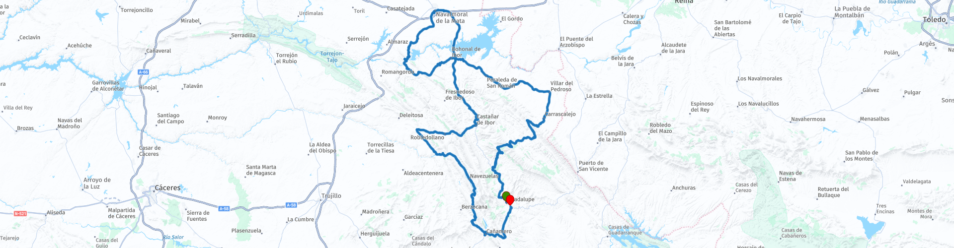
Round trip from Guadalupe to Navalmoral de la Mata

This route was brought to you by:
RouteXpert Nick Carthew - (MRA Master)
Last edit: 28-08-2025
 Route Summary
 I've awarded this route 3 stars ***. The roads, scenery, and attractions are all good.
 Share this route


Animation

Verdict


Duration
7h 30m

Mode of travel
Car or motorcycle

Distance
241.78 km

Countries

 RouteXpert Review
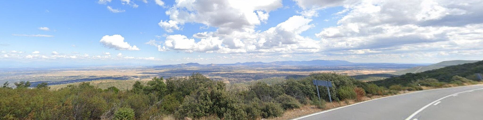
 Leaving Guadalupe on the very twisty EX118, you are soon travelling through thick woodland, on a thrilling road that has a good surface and plenty of fast bends, after approximately 12 km we use the much smaller CC-20.2 that will take you into the heart of the beautiful countryside with some great views from prominent positions. You will pass through several small mountain villages, all of which have somewhere for a coffee stop, I have suggested the village of Navatrasierra. After your coffee you'll climb to the top of the Puerto de Arrebatacapas, a popular climb for cyclists, once at the top you have a fantastic view across the flat plain towards the Sierra de Gredos mountains.
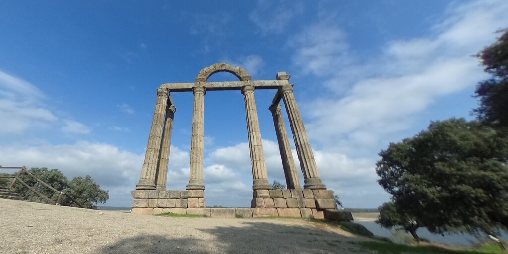
The next stop finds you at the ruins of a Roman temple on the shore of the largest reservoir in the area, Valdecanas Reservoir. The Roman Temple of Augustobriga, better known as " The Marbles "is a well preserved temple that was moved to it's current location after the construction of the Valdecañas Reservoir, which would end up flooding the entire area including the town of Talavera la Vieja, which was none other than the ancient Roman city of Augustobriga where the temple once stood.
The route crosses over the reservoir and heads to the large town of Navalmoral de la Mata, I have suggested a lunch stop here as there is a very good selection of restaurants offering some of the local specialties.
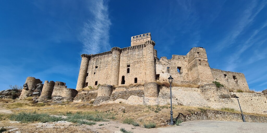
After lunch we visit Belvís de Monroy and the ruined Moorish castle, there is a good view of the castle to be had on the road out of the village.
We cross the River Tagus next, where a great view of the Valdecanas Dam can be seen from here, the dam that created the reservoir where the Roman Temple had to be moved from.
The Tagus is longest river in the Iberian Peninsula at 1,007 km long, with 716 km in Spain, 47 km along the border between Portugal and Spain and 275 km in Portugal, where it empties into the Atlantic Ocean near Lisbon. It drains an area of 80,100 square km, it truly is a mighty river.
The route back to Guadalupe will take you through more stunning scenery and there are many places to stop to take photos.
A great photo stop is at the la Portilla del Almonte, one of the most spectacular places in the whole of the mountain range of Las Villuercas. It is a fluvial defile (river gorge) that has been formed by the River Almonte in its westward course seeking to join the River Tagus. The Almonte Gorges are one of the most representative areas of the Villuercas-Ibores-Jara Geopark Guide . It's a spectacular river gorge, with a landscape more reminiscent of Middle Earth in The Lord of the Rings than Extremadura. As well as the impressive geology of the outcropping of Armorican quartzites through which the River Almonte makes its way, the visitor can also appreciate trace fossils of the crawling of trilobites (Cruziana) and the refuges of sandworms (Skolithos).
You can finish your tour by visiting the UNESCO Global Geopark Centre in Cañamero. Entry is free. The visit includes the various rooms of the centre and ends in the audiovisual room with the showing of a 3-D video on the formation processes and the geological history of our Geopark. The guide takes one hour.
This really is a great route for exploring this non touristy part of Spain.
Enjoy
 Links
Links  Usage
Usage Want to download this route?
You can download the route for free without MyRoute-app account. To do so, open the route and click 'save as'. Want to edit this route?
No problem, start by opening the route. Follow the tutorial and create your personal MyRoute-app account. After registration, your trial starts automatically.  Disclaimer
Use of this GPS route is at your own expense and risk. The route has been carefully composed and checked by a MyRoute-app accredited RouteXpert for use on TomTom, Garmin and MyRoute-app Navigation.
Changes may nevertheless have occurred due to changed circumstances, road diversions or seasonal closures. We therefore recommend checking each route before use.
Preferably use the route track in your navigation system. More information about the use of MyRoute-app can be found on the website under 'Community' or 'Academy'.