Pyrenees Mountains From Jaca in Spain to Campan in France

This route was brought to you by:
RouteXpert Guy Heyns - Sr RouteXpert
Last edit: 10-12-2024
 Route Summary
 But this certainly does not have to be a punishment on this tasty route that offers you the pearl of the Pyrenees - The Aubisque - from West to East.
You also pass the Soulor & the Tourmalet, so the fun is once again assured on this route that therefore easily takes away the 5 stars.
So a nice ride on good roads that can't ask for the best of the technical and still show you the full splendor of the Pyrenean high mountains.
 Share this route


Animation

Verdict


Duration
5h 37m

Mode of travel
Car or motorcycle

Distance
219.90 km

Countries


 RouteXpert Review
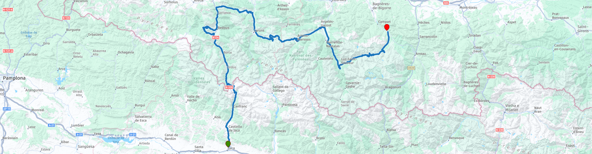
 The first thought is "Unfortunately, but unfortunately", but fortunately that is not the case in this case!
From Jaca you wind upstream of the Aragon or the 'Aragoi Ibaia' in the direction of the French Border. The Aragon has its source in the Pyrenees and then runs a good 130 kilometers to the south. After about 28 kilometers the route then curves away from the river to cross the Spanish-French border and the French switchbacks take over.
A nice intermezzo (and you can take that literally in this one) is offered to you in the village of Athas where a small but nice side jump is made to a very nice winding road. Whether or not to include it is up to you, but the advice here is that you should; it's a really nice detour.
In Escot the route turns to the right and the collen festival starts from West to East. The Marie-Blanque and the Prteigt are then the starters leading up to the icing on the cake (for me anyway…) the Aubisque. Particularly nice col to drive and the views of the mountains are mighty beautiful. The Soulor follows the Aubisque seamlessly, after which it is a nice relaxing drive to Arrens where you can take a break and refuel if necessary. Along the way you may find a pleasant break. And if nothing can be found there, Argelès-Gazost also offers you some great opportunities.
The road to Laz-Saint Sauveur, on the other hand, is quite large and busy (there are few alternatives in the region...) but offers a pleasant break in the form of the Pont Napoleon.
Napoleon III and Empress Eugenie liked to be pampered in the various spas in Luz-Saint-Sauveur. During one of his stays there, the emperor decided, among other things, to build the bridge, 65 meters high above the Gave. The arch has a diameter of 42 meters and the vault rests entirely on the steep rocks of both banks of the Gave. A 12 meter high column, made of Lourdes stone, shows the gratitude of the local population to his Imperial Highness and his consort. Beautiful, classic building that has stood the test of time beautifully. If you feel like it and they are there with the 'elastic', you can also admire the bridge upside down and from below. A matter of looking at the whole from all sides...
After the passage of the Pont Napoleon (which you also drive over) the route bends back to also climb the Col de Tourmalet on the west side. You will find well-deserved rest in Campan and it will surely be welcome. This ride of about 220 kilometers may not be technically demanding, but it is not to be underestimated.
Many cafes as we know them are not really to be found along the way. On this ride we regularly stopped at a supermarket to pick up a drink and / or snack for the road.
There are plenty of places to stop with a magnificent decor to consume the purchased good...


 Links
Links  Usage
Usage Want to download this route?
You can download the route for free without MyRoute-app account. To do so, open the route and click 'save as'. Want to edit this route?
No problem, start by opening the route. Follow the tutorial and create your personal MyRoute-app account. After registration, your trial starts automatically.  Disclaimer
Use of this GPS route is at your own expense and risk. The route has been carefully composed and checked by a MyRoute-app accredited RouteXpert for use on TomTom, Garmin and MyRoute-app Navigation.
Changes may nevertheless have occurred due to changed circumstances, road diversions or seasonal closures. We therefore recommend checking each route before use.
Preferably use the route track in your navigation system. More information about the use of MyRoute-app can be found on the website under 'Community' or 'Academy'.

Aragon
About this region
Aragon ( or , Spanish and Aragonese: Aragón [aɾaˈɣon], Catalan: Aragó [əɾəˈɣo]) is an autonomous community in Spain, coextensive with the medieval Kingdom of Aragon. In northeastern Spain, the Aragonese autonomous community comprises three provinces (from north to south): Huesca, Zaragoza, and Teruel. Its capital is Zaragoza. The current Statute of Autonomy declares Aragon a historic nationality of Spain.
Covering an area of 47720 km2 (18420 sq mi), the region's terrain ranges diversely from permanent glaciers to verdant valleys, rich pasture lands and orchards, through to the arid steppe plains of the central lowlands. Aragon is home to many rivers—most notably, the river Ebro, Spain's largest river in volume, which runs west–east across the entire region through the province of Zaragoza. It is also home to the highest mountains of the Pyrenees.
As of January 2020, the population of Aragon was 1329391, with over half of it living in its capital city, Zaragoza. During the same year, the economy of Aragon generated a GDP of €34687 million, which represents 3.1% of Spain's national GDP, and is currently 6th in per capita production behind Madrid, Basque Country, Navarre, Catalonia and La Rioja.In addition to its three provinces, Aragon is subdivided into 33 comarcas or counties. All comarcas of Aragon have a rich geopolitical and cultural history from its pre-Roman, Celtic and Roman days, four centuries of Islamic rule as Marca Superior of Al-Andalus or kingdom (or taifa) of Saraqusta, as lands that once belonged to the Frankish Marca Hispanica, counties that later formed the Kingdom of Aragon, and eventually the Crown of Aragon.
Read more on Wikipedia
Covering an area of 47720 km2 (18420 sq mi), the region's terrain ranges diversely from permanent glaciers to verdant valleys, rich pasture lands and orchards, through to the arid steppe plains of the central lowlands. Aragon is home to many rivers—most notably, the river Ebro, Spain's largest river in volume, which runs west–east across the entire region through the province of Zaragoza. It is also home to the highest mountains of the Pyrenees.
As of January 2020, the population of Aragon was 1329391, with over half of it living in its capital city, Zaragoza. During the same year, the economy of Aragon generated a GDP of €34687 million, which represents 3.1% of Spain's national GDP, and is currently 6th in per capita production behind Madrid, Basque Country, Navarre, Catalonia and La Rioja.In addition to its three provinces, Aragon is subdivided into 33 comarcas or counties. All comarcas of Aragon have a rich geopolitical and cultural history from its pre-Roman, Celtic and Roman days, four centuries of Islamic rule as Marca Superior of Al-Andalus or kingdom (or taifa) of Saraqusta, as lands that once belonged to the Frankish Marca Hispanica, counties that later formed the Kingdom of Aragon, and eventually the Crown of Aragon.
View region
 Statistics
  38
38Amount of RX reviews (Aragon)
 14481
14481Amount of visitors (Aragon)
 2484
2484Amount of downloads (Aragon)
 Route Collections in this region
 7 day roundtrip from Girona to Catalonia Andorra and the Pyrenees
The Pyrenees stretch for more than 450 kilometers from the Bay of Biscay in the west to the Cap de Creus on the Mediterranean. The mountain range, with peaks of more than 3000 meters, forms a natural barrier that cuts off the Iberian Peninsula from the rest of Europe. The main ridge of the mountain range also largely forms the state border between France and Spain, while the microstate Andorra lies between these two countries.
Bordering the Pyrenees is Catalonia, the hinterland of Barcelona. No wonder many new models of motorcycles are introduced to the press in Catalonia. There are many great ways to test the new models there. An additional advantage is that it is very quiet! You would almost say 'too quiet' because there is a danger that at some point you will use the entire width of the road, under the guise of 'you won't see oncoming traffic here'.... But let's keep it safe and stay on the right side of the center line.
These seven routes of this collection pass through these beautiful areas. Each and every one of these routes where especially the sides of the tires have a hard time. Whether on the gentle slopes in Catalonia or on the balcony roads in the Gorges in the French Pyrenees, make sure they're excited, because you can bet it's going to be exciting!
A few sights are discussed in the review for each route. These often tell something about the history of the area in which you drive. Fun facts, quite educational. There are also places where you can refuel and where you can drink coffee and/or have lunch. You are completely free to visit these places, you can of course also determine your own points of interest.
But the main thing you probably traveled to this area for is simply driving. And as mentioned above, you are in a true motorcycle paradise where the steering is fantastic!
Each route ends at a hotel. It is of course not an obligation to use these hotels, you can always find another place to stay in the area, that decision is up to you. My experience, however, is that they are all simple but good hotels for a very reasonable price. They are known and can be booked at booking.com.
The routes of these collections:
R01 - Girona to Sant Julia de Loria, 269km
R02 - Sant Julia de Loria to Pierrefitte Nestalas, 290km
R03 - Pierrefitte Nestalas to Barbastro, 291km
R04 - Barbastro to Puig Reig, 266km
R05 - Puig Reig to Figueres, 268km
R06 - Figueres to Quillan, 243km
R07 - Quillan to Gironam, 286km
Have fun driving these routes!
View Route Collection
A 5-day tour from Peniscola visiting Toledo Merida Avila Segovia Siquenza Barcelona
A 5-route, 5-day tour of Peniscola, Aranjuez, Toledo, Consuegra, Molinos, Merida, Avila, Segovia, seguiranza and Barcelona, taking in these sites will immerse you in the rich history and culture of Spain. From stunning medieval fortresses to charming windmill villages, you will pass through picturesque roads enjoying the exquisite local cuisine and natural beauty that each place has to offer. It will be an unforgettable experience full of discoveries and unforgettable moments. Definitely a trip worth taking!
View Route Collection