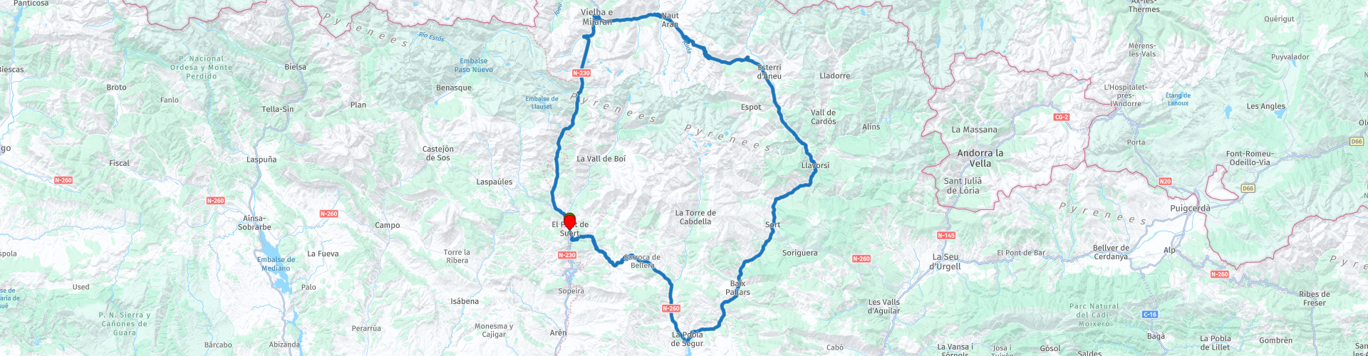
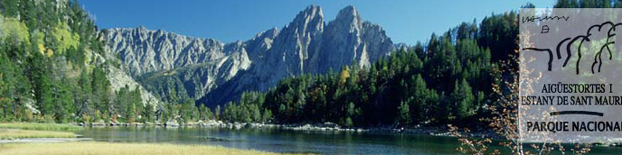
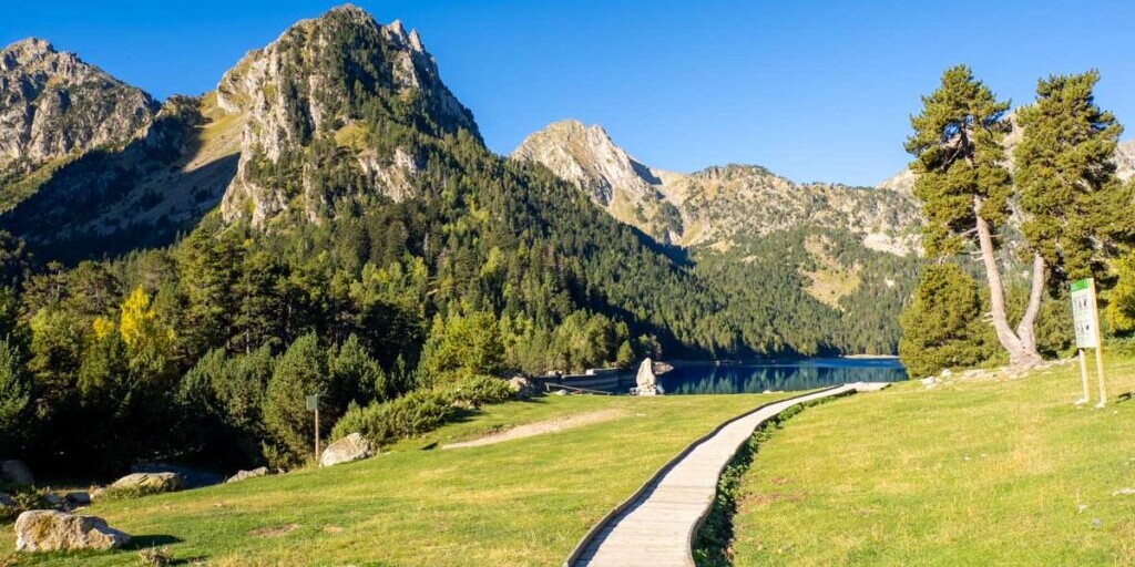
Roundtrip from Pont de Suert around Aiguestortes National Park

This route was brought to you by:
RouteXpert Jordi Honrubia MRA-RouteXpert
Last edit: 03-06-2025
 Route Summary
 5-star route for its landscapes and views, its winding roads with perfect asphalt and beautiful towns.
 Share this route


Animation

Verdict


Duration
4h 39m

Mode of travel
Car or motorcycle

Distance
177.73 km

Countries

 RouteXpert Review
 tells that Pont de Suert was made up of two towns, Pont and Suert. During a plague all the inhabitants of Suert
died, except an old woman, who remained as heiress of the village. She went to the village of Pont to offer all
her belongings in exchange for being cared for until her death. And so the two villages came together. The town
is situated at a height of 841 metres on the banks of the river Noguera Ribagorçana. For much of its 130 km
course the river forms the border between Catalonia and Aragon and this route follows it upstream for 27km.
Evidence of the importance of water can be seen when you pass under the colossal water pipe taking water to
the hydro electric plant back in Pont de Suert. The river valley varies and can be quite wide in places and then it
narrows so that you have vertical rock face next to the road but all the time travelling through beautiful scenery.
The Bono Tunnel is the first of several short tunnels taking the road through the mountain where the river gorge
is too narrow.
You’ll see the Baserca reservoir or Senet reservoir located on the Noguera Ribagorzana River surrounded by
peaks of over 3000 metres, including the Molieres and Besiberri peaks. The main purpose of the reservoir is
hydroelectricity. To this end, its waters can be diverted to the Moralets power station or to the Llauset reservoir,
at 2,200 meters of altitude, through a reversible channel. Likewise, there is a small hydroelectric plant at the
foot of the dam, known as the Baserca plant.
A little further on and you reach the Vielha tunnel, there are actually two parallel tunnels. The older one, which
is now only used for access and special loads is named Alfonso XIII Tunnel after King Alfonso XIII. It was
opened in 1948 and became the longest road tunnel in the world at 5240m until 1964, when the Great St
Bernard Tunnel was opened. The new tunnel, named Juan Carlos I Tunnel is a mere 5230 m long and was
opened in 2007. Exiting the tunnel you follow the River Nere along a beautiful valley road to the capital of the
Arán Valley, Vielha. The village is built at the point where both the Garona and Nere rivers meet. Its origins go
back to the Roman period, when it was called Vétula, and when, according to legend, it was home to the giant
Mandronius, who fought against the Roman invaders.
Following the Garona river now you’ll arrive at Salardú, a small town that has a maze of streets, alleys, little
squares and nooks and crannies that feature three elements: stone, wood and slate, a wise selection for these
have created a beautiful extension to the old town. The town was fortified in the Middle Ages on account of its
strategic position in the valley. The castle once stood in the upper part of the village, where there is now the
church of Sant Andreu. The town is popular because of its location and close proximity to ski resort of Baqueira
Beret. Baqueira-Beret is the largest and most visited winter resort in Spain, with 161 kilometers of marked
pistes. The resort was founded 60 years ago on the initiative of the local authorities in the Aran Valleyand has
grown into a well regarded ski resort.
It’s no surprise to learn that the higest point of this route is next at Port de la Bonaigua, 2072 metres above sea
level. The summit hosts big parking areas and an iconic cafe-restaurant where you can stop for a coffee.
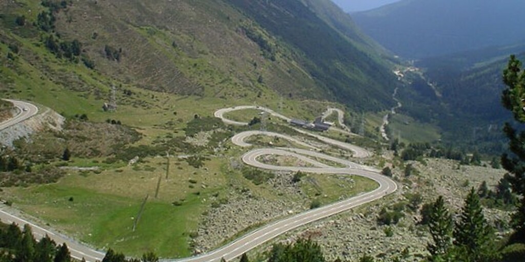
A great section of twisty road with tight hairpin bends comes next as you descend down through the River
Bonaigua valley, you have a great view of the road ahead from the Shelter de les Ares. The Bonaigua joins the
Noguera Pallaresa river and you follow it downstream to the beautiful Torrassa reservoir. The Torrassa
reservoir on the Noguera Pallaresa river was created by a dam that you can ride onto at the southern end.
The name of the Torrassa comes from the old and large watchtower - or torrassa - that existed in this place.
The route follows the Noguera Pallaresa river for the next 54 kilometers passing through several small villages,
each with there own unique flavour but all connected by the road through the beautiful Noguera Pallaresa river
valley. Most notable of these is Gerri de la Sal, a small medieval village that still retains its industrial and
architectural heritage: the Alfolí, or salt storehouse is now a museum and worth a visit along with the
Monastery of Santa Maria. The exploitation of the source of the salt was, until recently, the main economic
driving force for this town, which is reflected in its name.
Next come 3 tunnels, the first is only short and the next two are a little over 1 kilometer in length. Passing
through the first of these longer tunnels, the Túnel de l'Argenteria is like crossing into another world, the valley
is open when you enter and when you emerge the valley sides have closed in with vertical rock faces close to
the road. The opposite happens when you pass through the last tunnel, the valley sides open and you see more
sky.
At the most southerly point of this route is La Pobla de Segur, one of the most historic villages in the Lleida
Pyrenees and is located in the confluence of the rivers Noguera Pallaresa and Flamisell. La Pobla, often
associated with the railway, has been traditionally seen as the crossroads and main entrance to the high valleys
of the Pyrenees. The medieval heritage can be seen in the streets of this town, which was closed by two gates
until the 18th century. The suburbs of Fossar Vell and carrer d'Oran were built during the modern period and
were finally incorporated to the growing town in the 19th and 20th centuries. Despite its roots being, as in the
rest of the region, agriculture and animal husbandry, it is nowadays based as well in retail, services and tourism.
This route now follows the Flamisell river for 10 kilometers to the village of Senterada then follow one of its
tributaries, the Sarroca River for a further 10 kilometers where you will pass below the hilltop village of Sarroca
de Bellera. From here there is another great section of twisty road with tight hairpin bends offering some
breathtaking views.
Passing through the short 140m Lavaix tunnel indicates that you are close to the end of this route, back where
you started in Pont de Suert.
 Links
Links  Usage
Usage Want to download this route?
You can download the route for free without MyRoute-app account. To do so, open the route and click 'save as'. Want to edit this route?
No problem, start by opening the route. Follow the tutorial and create your personal MyRoute-app account. After registration, your trial starts automatically.  Disclaimer
Use of this GPS route is at your own expense and risk. The route has been carefully composed and checked by a MyRoute-app accredited RouteXpert for use on TomTom, Garmin and MyRoute-app Navigation.
Changes may nevertheless have occurred due to changed circumstances, road diversions or seasonal closures. We therefore recommend checking each route before use.
Preferably use the route track in your navigation system. More information about the use of MyRoute-app can be found on the website under 'Community' or 'Academy'.

Aragon
About this region
Aragon ( or , Spanish and Aragonese: Aragón [aɾaˈɣon], Catalan: Aragó [əɾəˈɣo]) is an autonomous community in Spain, coextensive with the medieval Kingdom of Aragon. In northeastern Spain, the Aragonese autonomous community comprises three provinces (from north to south): Huesca, Zaragoza, and Teruel. Its capital is Zaragoza. The current Statute of Autonomy declares Aragon a historic nationality of Spain.
Covering an area of 47720 km2 (18420 sq mi), the region's terrain ranges diversely from permanent glaciers to verdant valleys, rich pasture lands and orchards, through to the arid steppe plains of the central lowlands. Aragon is home to many rivers—most notably, the river Ebro, Spain's largest river in volume, which runs west–east across the entire region through the province of Zaragoza. It is also home to the highest mountains of the Pyrenees.
As of January 2020, the population of Aragon was 1329391, with over half of it living in its capital city, Zaragoza. During the same year, the economy of Aragon generated a GDP of €34687 million, which represents 3.1% of Spain's national GDP, and is currently 6th in per capita production behind Madrid, Basque Country, Navarre, Catalonia and La Rioja.In addition to its three provinces, Aragon is subdivided into 33 comarcas or counties. All comarcas of Aragon have a rich geopolitical and cultural history from its pre-Roman, Celtic and Roman days, four centuries of Islamic rule as Marca Superior of Al-Andalus or kingdom (or taifa) of Saraqusta, as lands that once belonged to the Frankish Marca Hispanica, counties that later formed the Kingdom of Aragon, and eventually the Crown of Aragon.
Read more on Wikipedia
Covering an area of 47720 km2 (18420 sq mi), the region's terrain ranges diversely from permanent glaciers to verdant valleys, rich pasture lands and orchards, through to the arid steppe plains of the central lowlands. Aragon is home to many rivers—most notably, the river Ebro, Spain's largest river in volume, which runs west–east across the entire region through the province of Zaragoza. It is also home to the highest mountains of the Pyrenees.
As of January 2020, the population of Aragon was 1329391, with over half of it living in its capital city, Zaragoza. During the same year, the economy of Aragon generated a GDP of €34687 million, which represents 3.1% of Spain's national GDP, and is currently 6th in per capita production behind Madrid, Basque Country, Navarre, Catalonia and La Rioja.In addition to its three provinces, Aragon is subdivided into 33 comarcas or counties. All comarcas of Aragon have a rich geopolitical and cultural history from its pre-Roman, Celtic and Roman days, four centuries of Islamic rule as Marca Superior of Al-Andalus or kingdom (or taifa) of Saraqusta, as lands that once belonged to the Frankish Marca Hispanica, counties that later formed the Kingdom of Aragon, and eventually the Crown of Aragon.
View region
 Statistics
  38
38Amount of RX reviews (Aragon)
 14482
14482Amount of visitors (Aragon)
 2484
2484Amount of downloads (Aragon)
 Route Collections in this region
 7 day roundtrip from Girona to Catalonia Andorra and the Pyrenees
The Pyrenees stretch for more than 450 kilometers from the Bay of Biscay in the west to the Cap de Creus on the Mediterranean. The mountain range, with peaks of more than 3000 meters, forms a natural barrier that cuts off the Iberian Peninsula from the rest of Europe. The main ridge of the mountain range also largely forms the state border between France and Spain, while the microstate Andorra lies between these two countries.
Bordering the Pyrenees is Catalonia, the hinterland of Barcelona. No wonder many new models of motorcycles are introduced to the press in Catalonia. There are many great ways to test the new models there. An additional advantage is that it is very quiet! You would almost say 'too quiet' because there is a danger that at some point you will use the entire width of the road, under the guise of 'you won't see oncoming traffic here'.... But let's keep it safe and stay on the right side of the center line.
These seven routes of this collection pass through these beautiful areas. Each and every one of these routes where especially the sides of the tires have a hard time. Whether on the gentle slopes in Catalonia or on the balcony roads in the Gorges in the French Pyrenees, make sure they're excited, because you can bet it's going to be exciting!
A few sights are discussed in the review for each route. These often tell something about the history of the area in which you drive. Fun facts, quite educational. There are also places where you can refuel and where you can drink coffee and/or have lunch. You are completely free to visit these places, you can of course also determine your own points of interest.
But the main thing you probably traveled to this area for is simply driving. And as mentioned above, you are in a true motorcycle paradise where the steering is fantastic!
Each route ends at a hotel. It is of course not an obligation to use these hotels, you can always find another place to stay in the area, that decision is up to you. My experience, however, is that they are all simple but good hotels for a very reasonable price. They are known and can be booked at booking.com.
The routes of these collections:
R01 - Girona to Sant Julia de Loria, 269km
R02 - Sant Julia de Loria to Pierrefitte Nestalas, 290km
R03 - Pierrefitte Nestalas to Barbastro, 291km
R04 - Barbastro to Puig Reig, 266km
R05 - Puig Reig to Figueres, 268km
R06 - Figueres to Quillan, 243km
R07 - Quillan to Gironam, 286km
Have fun driving these routes!
View Route Collection
A 5-day tour from Peniscola visiting Toledo Merida Avila Segovia Siquenza Barcelona
A 5-route, 5-day tour of Peniscola, Aranjuez, Toledo, Consuegra, Molinos, Merida, Avila, Segovia, seguiranza and Barcelona, taking in these sites will immerse you in the rich history and culture of Spain. From stunning medieval fortresses to charming windmill villages, you will pass through picturesque roads enjoying the exquisite local cuisine and natural beauty that each place has to offer. It will be an unforgettable experience full of discoveries and unforgettable moments. Definitely a trip worth taking!
View Route Collection