04 Arriondas a Burgos por Picos De Europa y Riano

This route was brought to you by:
RouteXpert Jordi Honrubia MRA-RouteXpert
Last edit: 15-07-2025
 Route Summary
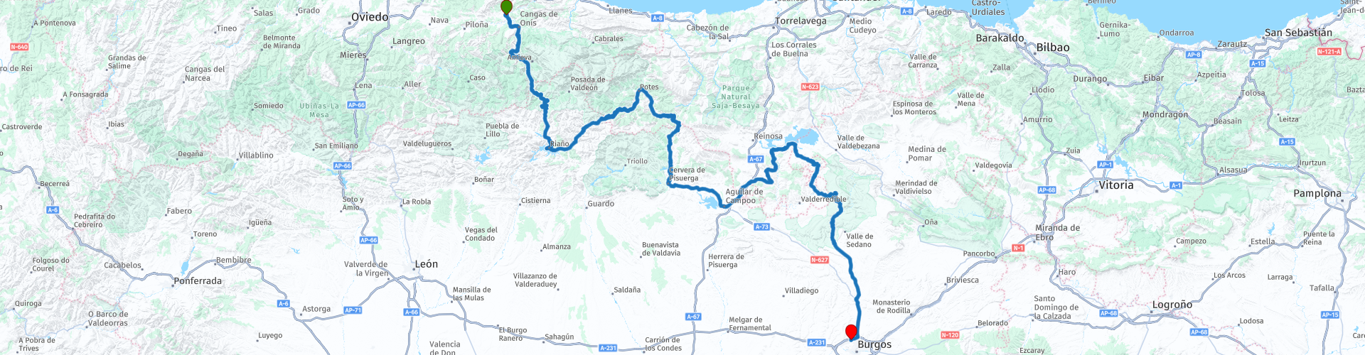
 On this fourth road trip, we depart from the charming town of Arriondas and head towards Burgos, crossing some of the most stunning landscapes in northern Spain. This route takes us through the majestic Picos de Europa, bordering the impressive Ebro Reservoir and passing through mountain passes and breathtaking viewpoints between Cantabria and Castile and León.
The route also presents us with a collection of picturesque villages that look like something out of a Christmas card—authentic nativity scenes in the heart of nature—where time seems to stand still.
A route to see again… and to vibrate again.
Between curves, peaks, and rural charm, this journey has it all: captivating landscapes, iconic viewpoints, and countless hidden corners with soul.
I give this route 5 stars without hesitation. A route that promises... and delivers. With everything you'd love to do on a trip: roads, landscapes, mountain passes, and countless moments that will remain in our retinas and cameras as memories.
 Share this route


Animation

Verdict


Duration
12h 21m

Mode of travel
Car or motorcycle

Distance
377.91 km

Countries

 RouteXpert Review
 In this fourth installment of our adventure through Spain, we embark on a journey that is pure geographical poetry. We depart from the charming Asturian village of Arriondas and, after several hundred kilometers of uninterrupted beauty, culminate in the monumental city of Burgos. Along the way, imposing mountains, majestic reservoirs, viewpoints that seem to touch the sky, and towns frozen in time await us, like living photographs of another era. This route is not just a journey through landscapes: it is a journey through the very essence of the northern Iberian Peninsula, a succession of natural and cultural settings that awaken the senses and caress the traveler's soul.
Start in Arriondas: mountains, legends and the breath of the Sella River
We begin our adventure in Arriondas, an Asturian town surrounded by mountains and known for being the starting point of the International Sella Descent. Beyond the excitement this event evokes each year, Arriondas offers an unusual peace, where the green of the mountains seems to embrace every corner. From here, we descend toward Cangas de Onís, a place steeped in history, known as the first capital of the Kingdom of Asturias.
We cross the iconic Roman Bridge of Cangas, where the Cruz de la Victoria hangs solemnly. Below, the Sella River flows with that powerful calm that only ancient rivers possess. It's hard not to stop and contemplate and feel how time slows down in this place.
Via the N-625: following the Sella River towards the peaks
From Cangas, we take the N-625 national highway, one of those roads that seem made for visual delight. On one side, the Sella River meanders past us, clean, wild, and teeming with life. Along the way, we come across the salmon spawning station, a fascinating and educational spot where we can observe the ancient struggle of these fish to perpetuate their species.
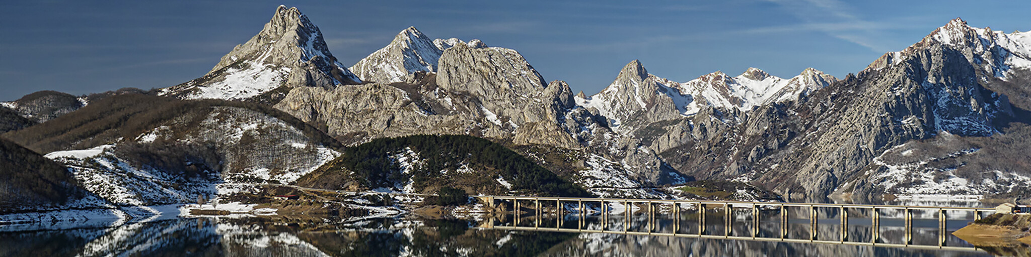
Viewpoints begin to appear one after another. The views of the Picos de Europa are simply sublime. Depending on the season, the snow-capped peaks contrast with the green valleys and gray limestone cliffs that rise majestically. The road delves into a natural universe that changes with every curve.
Puerto del Pontón and Riaño: where the mountains are reflected in the water
We ascend to Puerto del Pontón, a classic mountain pass between Asturias and León. From its summit, the panorama is unforgettable: a sea of peaks silhouetted against the sky. We begin the descent toward Riaño, one of the most striking towns on this route.
The Riaño Reservoir appears before us like a mirror of mountains. Its waters reflect the surrounding peaks, creating a hypnotic image. We cross one of its bridges as the landscape envelops us with a sense of serene immensity. Riaño is not just a town: it's a natural balcony overlooking the Picos de Europa, a living postcard.
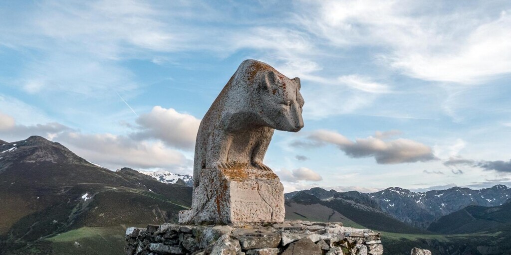
Puerto de San Glorio and the viewpoints of infinity
From Riaño, we take the N-621, heading towards the spectacular Puerto de San Glorio. This road climbs gently through curves that seem designed for enjoyment. As we gain altitude, the views become increasingly magnificent.
At the summit, we make a mandatory stop at the Mirador del Oso (Bear Lookout). There, a metal sculpture of a bear climbing a rock welcomes us. From this point, the eastern and central massifs of the Picos de Europa and the Liébana Valley stretch out like a rolling green canvas.
A little further on, Mirador del Corzo offers another perspective. Simpler but equally special, from here the horizon seems endless. The fresh air, the natural silence, and the majesty of the surroundings remind us how small everything else is.
Potes: tradition, stone and flavor
We descend toward Potes, an architectural gem nestled among the mountains, with its cobblestone streets, wooden houses, and ancient bridges spanning the Deva River. At this point on the route, a culinary break is almost obligatory. The cocido lebaniego, with its small chickpeas, cabbage, and sausage, is a mountain delicacy that comforts body and soul.
From Potes, we head south, leaving Cantabria behind to enter the solitary and spectacular region of the Palentine Mountains. Forests, rivers, and valleys welcome us with open arms, in one of the least traveled and most surprising areas of the route.
The Romanesque architecture of Cervera and Aguilar, and the murmur of the Pisuerga River
We arrived at Cervera de Pisuerga, a village that still retains its rural charm. The Pisuerga River flows peacefully through this area, and its surroundings are dotted with hiking trails and small Romanesque churches.
We continue on to Aguilar de Campoo, the land of biscuits (Gullón was born here), but also of an impressive Romanesque heritage. Its reservoir, its collegiate church, and the castle that crowns the town are just some of the hidden gems.
Bordering the Ebro Reservoir: mirror-like calm and bird flight
From Aguilar, we head towards the Ebro Reservoir. This body of water, shared by Cantabria and Burgos, is a paradise for waterfowl and a haven for the soul. We skirt it calmly, enjoying every kilometer as if it were the last.
The landscape expands, the sky is reflected in the water, and the wind seems to tell stories of shepherds and ancient snows. It's one of the most contemplative stretches of the entire route.
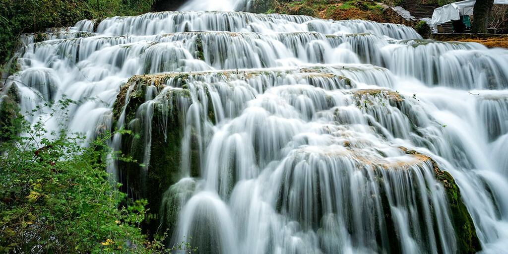
Orbaneja del Castillo: the town of waterfalls
And then, like something out of a fairy tale, Orbaneja del Castillo appears. This small Burgos village, nestled in a gorge, is a miracle of stone and water. As soon as you arrive, a waterfall flows through the center of the village, cascading from a grotto to form natural pools of turquoise water.
The houses seem carved into the rock. The caves, grottos, and karst formations give it the air of an enchanted village. Here, it's not about visiting: it's about staying, even for a while, simply contemplating.
Final destination: Burgos, history and a well-deserved rest
From Orbaneja, we continue on to Burgos, where our journey ends. Arriving in this Castilian city is like the closing of an unforgettable book. After so much nature, Burgos welcomes us with its Gothic cathedral, the Arlanzón River, and its Castilian atmosphere, sober yet welcoming.
We stayed at the HQ La Galería Hotel and Restaurant, where we finally dropped our backpacks and took a deep breath. Because this wasn't just another hike: it was a complete experience, a journey of emotions, flavors, landscapes, and shared moments.
This route has undoubtedly been another complete and exciting experience on any other journey through Spain. Imposing mountains, fairytale villages, legendary rivers, traditional cuisine, viewpoints that touch the sky, and a variety of landscapes that never cease to amaze—diversity, beauty, authenticity, and soul. A route not only explored with wheels, but also with the heart. Highly recommended for those who love roads steeped in history and nature alive around every bend.
 Links
Links  Usage
Usage Want to download this route?
You can download the route for free without MyRoute-app account. To do so, open the route and click 'save as'. Want to edit this route?
No problem, start by opening the route. Follow the tutorial and create your personal MyRoute-app account. After registration, your trial starts automatically.  Disclaimer
Use of this GPS route is at your own expense and risk. The route has been carefully composed and checked by a MyRoute-app accredited RouteXpert for use on TomTom, Garmin and MyRoute-app Navigation.
Changes may nevertheless have occurred due to changed circumstances, road diversions or seasonal closures. We therefore recommend checking each route before use.
Preferably use the route track in your navigation system. More information about the use of MyRoute-app can be found on the website under 'Community' or 'Academy'.

Asturias
About this region
Asturias (, Spanish: [asˈtuɾjas]; Asturian: Asturies [asˈtuɾjes; -ɾjɪs]), officially the Principality of Asturias (Spanish: Principado de Asturias; Asturian: Principáu d'Asturies; Galician-Asturian: Principao d'Asturias), is an autonomous community in northwest Spain.
It is coextensive with the province of Asturias and contains some of the territory that was part of the larger Kingdom of Asturias in the Middle Ages. Divided into eight comarcas (counties), the autonomous community of Asturias is bordered by Cantabria to the east, by León (Castile and León) to the south, by Lugo (Galicia) to the west, and by the Cantabrian sea to the north.
Asturias is situated in a mountainous setting with vast greenery and lush vegetation, making it part of Green Spain. The region has a maritime climate. It receives plenty of annual rainfall and little sunshine by Spanish standards and has very moderated seasons, most often averaging in the lower 20s celsius. Heatwaves are rare due to mountains blocking southerly winds. Winters are very mild for the latitude, especially near sea level.
The most important cities are the communal capital, Oviedo, the seaport and largest city Gijón, and the industrial town of Avilés. Other municipalities in Asturias include Cangas de Onís, Cangas del Narcea, Gozón, Grado, Langreo, Llanera, Laviana, Lena, Llanes, Mieres, Siero, Valdés, Vegadeo and Villaviciosa (see also List of municipalities and comarcas in Asturias).
Asturias is also home of the Princess of Asturias Awards.
Read more on Wikipedia
It is coextensive with the province of Asturias and contains some of the territory that was part of the larger Kingdom of Asturias in the Middle Ages. Divided into eight comarcas (counties), the autonomous community of Asturias is bordered by Cantabria to the east, by León (Castile and León) to the south, by Lugo (Galicia) to the west, and by the Cantabrian sea to the north.
Asturias is situated in a mountainous setting with vast greenery and lush vegetation, making it part of Green Spain. The region has a maritime climate. It receives plenty of annual rainfall and little sunshine by Spanish standards and has very moderated seasons, most often averaging in the lower 20s celsius. Heatwaves are rare due to mountains blocking southerly winds. Winters are very mild for the latitude, especially near sea level.
The most important cities are the communal capital, Oviedo, the seaport and largest city Gijón, and the industrial town of Avilés. Other municipalities in Asturias include Cangas de Onís, Cangas del Narcea, Gozón, Grado, Langreo, Llanera, Laviana, Lena, Llanes, Mieres, Siero, Valdés, Vegadeo and Villaviciosa (see also List of municipalities and comarcas in Asturias).
Asturias is also home of the Princess of Asturias Awards.
View region
 Statistics
  16
16Amount of RX reviews (Asturias)
 22031
22031Amount of visitors (Asturias)
 1264
1264Amount of downloads (Asturias)
 Route Collections in this region
 Three tours in and around Picos de Europa Northern Spain
The Picos de Europa is a mountainous area in northern Spain, next to the Basque Country. In the middle is the village of Posada de Valdeon, which cannot be reached by motorbike from the north: you have to drive around the Picos via Potes or Sames. We stayed overnight in Posada de Valdeon in Hostal Casa Abascal. A great hotel with breakfast option. You can eat in a restaurant in the village with usually a choice of two menus.
There are all kinds of nature reserves around the Picos. These three routes take you through some of them. There are gorges to see, viewpoints, reservoirs and you can walk more than fine. If you like walking, bring your walking shoes.
But we come to ride and it's going great. Excellent roads with the occasional piece of unpaved so that you do not have to detour far for another attraction. You can eat delicious food and the people are very nice and hospitable. And because the route to Lourdes goes above the Picos, there are also pilgrimage sites and very beautiful churches and monasteries. The most beautiful thing in this area is the nature: breathtakingly beautiful with wild animals, rugged mountains and wild rivers.
All in all, you can spend at least 4 days here if you take a day of rest or go for a walk.
View Route Collection
Santander to Roscoff via Picos de Europa Pyrenees West coast of France
A tour with 9 routes that all link up, starting from the ferry port of Santander to Potes using lots of twisty roads. The next route is a truly memorable round tour from Potes of the ever popular Picos de Europa. Then the tour heads south and east past reservoirs and picking up the mighty Ebro river and follow it to Miranda de Ebro. Route 4 carries on east towards the Pyrenees with more twisty roads to the destination of Sos del Rey Catolico, a fantastic fortified hilltop village. The next route takes you over the Pyrenees with the chance of a cable car ride up a mountain for lunch. Route 6 is the first day in France and it is a pleasant ride past fields of sunflowers and maize, pine forests and through the Landes de Gascogne Regional Natural Park. Then you cross over the mighty Gironde estuary by ferry and head to the finish at the popular costal town of La Rochelle. We stayed for two night in La Rochelle to sample the delights of this delightful town. Route 7 hugs the coast as it travels north and then crosses the mighty Loire river for a night in Saint Nazaire. Route 8 starts off with a visit to the U boat submarine pens in Saint Nazaire, then through the salt production 'fields' of Guerande and onto Concarneau, another historic walled city that must be visited. The final route takes you to Pointe du Raz then onto Locronan, a medieval village listed as one of the most beautiful villages of France. Then it travels over the Térénez bridge, the world's first curved cable-stayed bridge. Then you enter and travel through the Armorique Regional Natural Park to spend the night at a B&B hotel in Morlaix ready for a short ride in the morning to catch the ferry at Roscoff.
View Route Collection