02 Picos de Europa Round trip from Potes

This route was brought to you by:
RouteXpert Nick Carthew - (MRA Master)
Last edit: 21-03-2025
 Route Summary
  Share this route


Animation

Verdict


Duration
7h 13m

Mode of travel
Car or motorcycle

Distance
200.64 km

Countries

 RouteXpert Review
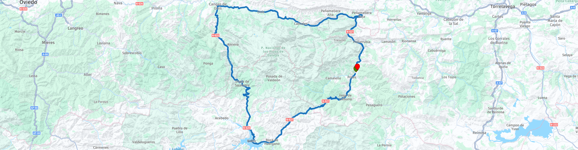
 This route uses just 3 roads in 200 kms which equates to riding or driving heaven!
From the start at Potes, the magnificent N-621 follows the Rio Quiviesa for 7 miles (11 kms), around gentle bends and with the mountains in the distance getting ever closer. The road changes and becomes more thrilling after the first hairpin bends at Vada. It climbs higher and higher on the San Glorio Pass giving you spectacular views around every corner. Several sets of hairpin bends later and you arrive at the most iconic and instantly recognisable statue, the Roe deer at Mirador del Corzo. It's almost obligatory to stop for a photo.
Carrying on up and up and you reach the summit of the San Glorio Pass at 1609 metres, here you have the option to turn right up a steep, twisting narrow track to see the statue of the Cantabrian Bear at Mirador del Orso the views from this new altitude of 1685 metres are breathtaking.
What goes up must come down, so now the route descends but this time in a more gentle fashion but the road does become more exciting as you follow the gorge carved out by the Naranco Stream and you pass through the La Hoz rock tunnel.
As the landscape levels out you make your way to the huge reservoir at Riaño. Here you can look at the water with a background of mountains and take a rest, there is fuel at Riaño too. The construction of the reservoir began in 1965, although certain social and political circumstances delayed its opening until the late 80s. Whatever the politics were, it's a beautiful reservoir.
From here we take another great road, the N-625 and it's not long before you reach the Puerto del Pontón after climbing to a height of 1280 metres a climb that has been used by the Spanish cycling race, The Vuelta. The summit here also marks the border of the Picos de Europa National Park, the route remains in the park for the next 20 kilometres.
The further you progress on the N-625 the higher your expectations rise as you sense that something special is coming.
Passing through the Oseja de Sajambre rock tunnel is like passing through a portal to another world as you approach the Desfiladero de los Beyos, a deep gorge that is very exciting and sometimes very exposed which has numerous twists and turns. The road is asphalted but extremely narrow. It is characterised by the vertical walls and the narrowing of the valley produced by the erosion of Sella River.
Anyone who travels along this national road that connects the province of León with Asturias via the Puerto del Pontón will surely share the famous words of French scientist and mountaineer Paul Labrouche, immortalized on the stone plaque that can be seen at the height of the Vidosa Bridge, in the middle of the gorge, he compares it to famous gorges around the world, it reads:
"The Sella Gorge is the steepest and most impressive of the famous gorges. Pierre Lys and Saint-Georges , in the Aude Pyrenees; the Fier, in Savoy, and the Via Mala, in Grisons; the Chiffa, in the Atlas; the Khakoueta Gap, in the Soude Valley, and Hell's Street, on the Lys, can only give—on a very small scale—an impression of the fantastic notch through which the engineers of Castile managed to carve a road."
I can't argue against that!
For this route, the N-625 ends at the city of Cangas de Onís, also capital of the area of the same name.
The most representative feature is its Roman Bridge, declared to be a Historic-Artistic Site in 1931. You can see this by turning left at the first set of lights as you enter the city, it really is quite amazing.
The route takes you to a free motorcycle parking area where you'll also see a motorcycle statue that has been made from, what looks like two millstones and some large river boulders, it has a Flintstone's look about it and tempts you on for a photo. There is a good selection of shops, bars and restaurants making it an ideal lunch stop.
After lunch, the route takes the AS-114 and it's a nice gentle ride travelling through countryside and villages.
Your eyes are in for a nice surprise as you go around the corner after Canales. The vista opens up again and the road has the feeling of a French balcony road, clinging onto the side of the mountain making the journey even more exciting. The route follows this limestone gorge, following first the Rio Casano and then the Rio Cares, in some places the rock overhangs the road. The Rio Cares joins the Rio Deva at Panes which is where this route makes it's last turn, back onto the N-621 so you follow the river and N-621 back towards Potes.
We chose to stop for another coffee just before entering the most spectacular part of the Desfiladero de la Hermida.
This steep sided, 21 km gorge is the longest in the Iberian Peninsula. The Deva River runs through its interior, flanked by rock walls that reach up to 600 metres in height, making the gorge a true scenic spectacle. Apart from the Deva River, there's barely enough room in La Hermida for the winding N-621.
Fill up with fuel for tomorrow just before reaching Potes.
Enjoy.


 Links
Links  Usage
Usage Want to download this route?
You can download the route for free without MyRoute-app account. To do so, open the route and click 'save as'. Want to edit this route?
No problem, start by opening the route. Follow the tutorial and create your personal MyRoute-app account. After registration, your trial starts automatically.  Disclaimer
Use of this GPS route is at your own expense and risk. The route has been carefully composed and checked by a MyRoute-app accredited RouteXpert for use on TomTom, Garmin and MyRoute-app Navigation.
Changes may nevertheless have occurred due to changed circumstances, road diversions or seasonal closures. We therefore recommend checking each route before use.
Preferably use the route track in your navigation system. More information about the use of MyRoute-app can be found on the website under 'Community' or 'Academy'.

Asturias
About this region
Asturias (, Spanish: [asˈtuɾjas]; Asturian: Asturies [asˈtuɾjes; -ɾjɪs]), officially the Principality of Asturias (Spanish: Principado de Asturias; Asturian: Principáu d'Asturies; Galician-Asturian: Principao d'Asturias), is an autonomous community in northwest Spain.
It is coextensive with the province of Asturias and contains some of the territory that was part of the larger Kingdom of Asturias in the Middle Ages. Divided into eight comarcas (counties), the autonomous community of Asturias is bordered by Cantabria to the east, by León (Castile and León) to the south, by Lugo (Galicia) to the west, and by the Cantabrian sea to the north.
Asturias is situated in a mountainous setting with vast greenery and lush vegetation, making it part of Green Spain. The region has a maritime climate. It receives plenty of annual rainfall and little sunshine by Spanish standards and has very moderated seasons, most often averaging in the lower 20s celsius. Heatwaves are rare due to mountains blocking southerly winds. Winters are very mild for the latitude, especially near sea level.
The most important cities are the communal capital, Oviedo, the seaport and largest city Gijón, and the industrial town of Avilés. Other municipalities in Asturias include Cangas de Onís, Cangas del Narcea, Gozón, Grado, Langreo, Llanera, Laviana, Lena, Llanes, Mieres, Siero, Valdés, Vegadeo and Villaviciosa (see also List of municipalities and comarcas in Asturias).
Asturias is also home of the Princess of Asturias Awards.
Read more on Wikipedia
It is coextensive with the province of Asturias and contains some of the territory that was part of the larger Kingdom of Asturias in the Middle Ages. Divided into eight comarcas (counties), the autonomous community of Asturias is bordered by Cantabria to the east, by León (Castile and León) to the south, by Lugo (Galicia) to the west, and by the Cantabrian sea to the north.
Asturias is situated in a mountainous setting with vast greenery and lush vegetation, making it part of Green Spain. The region has a maritime climate. It receives plenty of annual rainfall and little sunshine by Spanish standards and has very moderated seasons, most often averaging in the lower 20s celsius. Heatwaves are rare due to mountains blocking southerly winds. Winters are very mild for the latitude, especially near sea level.
The most important cities are the communal capital, Oviedo, the seaport and largest city Gijón, and the industrial town of Avilés. Other municipalities in Asturias include Cangas de Onís, Cangas del Narcea, Gozón, Grado, Langreo, Llanera, Laviana, Lena, Llanes, Mieres, Siero, Valdés, Vegadeo and Villaviciosa (see also List of municipalities and comarcas in Asturias).
Asturias is also home of the Princess of Asturias Awards.
View region
 Statistics
  16
16Amount of RX reviews (Asturias)
 23497
23497Amount of visitors (Asturias)
 1347
1347Amount of downloads (Asturias)
 Route Collections in this region
 Three tours in and around Picos de Europa Northern Spain
The Picos de Europa is a mountainous area in northern Spain, next to the Basque Country. In the middle is the village of Posada de Valdeon, which cannot be reached by motorbike from the north: you have to drive around the Picos via Potes or Sames. We stayed overnight in Posada de Valdeon in Hostal Casa Abascal. A great hotel with breakfast option. You can eat in a restaurant in the village with usually a choice of two menus.
There are all kinds of nature reserves around the Picos. These three routes take you through some of them. There are gorges to see, viewpoints, reservoirs and you can walk more than fine. If you like walking, bring your walking shoes.
But we come to ride and it's going great. Excellent roads with the occasional piece of unpaved so that you do not have to detour far for another attraction. You can eat delicious food and the people are very nice and hospitable. And because the route to Lourdes goes above the Picos, there are also pilgrimage sites and very beautiful churches and monasteries. The most beautiful thing in this area is the nature: breathtakingly beautiful with wild animals, rugged mountains and wild rivers.
All in all, you can spend at least 4 days here if you take a day of rest or go for a walk.
View Route Collection
Santander to Roscoff via Picos de Europa Pyrenees West coast of France
A tour with 9 routes that all link up, starting from the ferry port of Santander to Potes using lots of twisty roads. The next route is a truly memorable round tour from Potes of the ever popular Picos de Europa. Then the tour heads south and east past reservoirs and picking up the mighty Ebro river and follow it to Miranda de Ebro. Route 4 carries on east towards the Pyrenees with more twisty roads to the destination of Sos del Rey Catolico, a fantastic fortified hilltop village. The next route takes you over the Pyrenees with the chance of a cable car ride up a mountain for lunch. Route 6 is the first day in France and it is a pleasant ride past fields of sunflowers and maize, pine forests and through the Landes de Gascogne Regional Natural Park. Then you cross over the mighty Gironde estuary by ferry and head to the finish at the popular costal town of La Rochelle. We stayed for two night in La Rochelle to sample the delights of this delightful town. Route 7 hugs the coast as it travels north and then crosses the mighty Loire river for a night in Saint Nazaire. Route 8 starts off with a visit to the U boat submarine pens in Saint Nazaire, then through the salt production 'fields' of Guerande and onto Concarneau, another historic walled city that must be visited. The final route takes you to Pointe du Raz then onto Locronan, a medieval village listed as one of the most beautiful villages of France. Then it travels over the Térénez bridge, the world's first curved cable-stayed bridge. Then you enter and travel through the Armorique Regional Natural Park to spend the night at a B&B hotel in Morlaix ready for a short ride in the morning to catch the ferry at Roscoff.
View Route Collection