Roundtrip Posada de Valdeon Covadonga Ribadesella Ponga

This route was brought to you by:
RouteXpert Evert Kuiken
Last edit: 22-12-2020
 Route Summary
  Share this route


Animation

Verdict


Duration
6h 41m

Mode of travel
Car or motorcycle

Distance
276.03 km

Countries

 RouteXpert Review
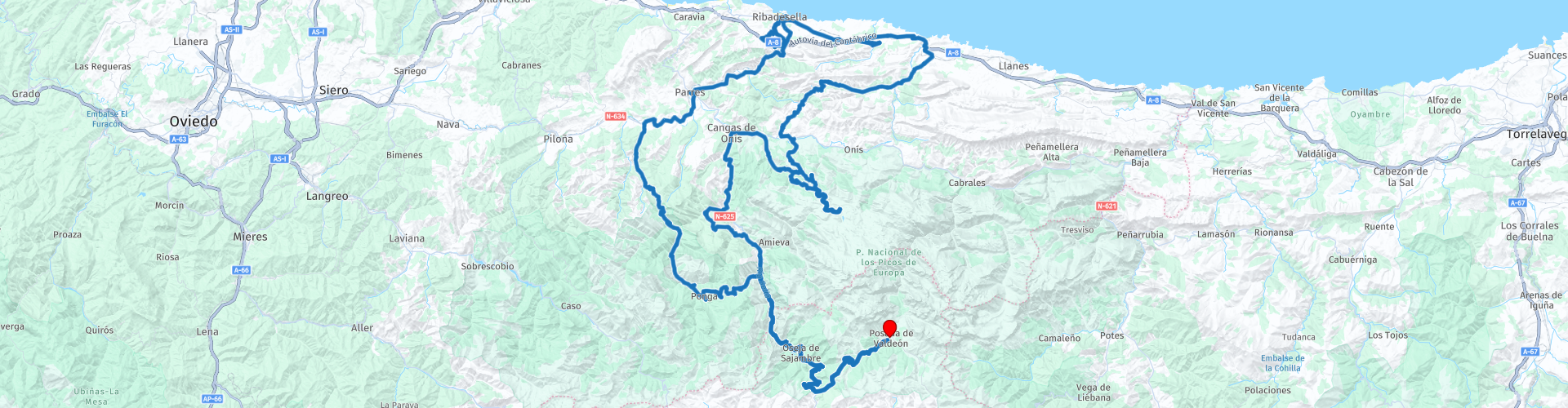
 At Restaurante Orandi (RP 6) you can drink coffee. From here a tourist piece starts. Almost everything here is busy and touristy. This place was still quiet when we were there but the huge parking lot suggested it is normally busier. You can also drive to Covadonga or have a cup of coffee on top of the mountain, but then you will be considerably more expensive. You now drive up the mountain to and along Lago Enol, after which you can park on top of the mountain. There is plenty to do there. Lago Enol is fun. The viewpoint Mirador de La Picota is very beautiful (although we only saw fog ...) and you should also see Mirador del Principe de Asturias. You can eat at Restaurante El Casín (simple) or at Bar Maria Rosa (more luxurious). There is also a visitor center: Centro de Visitantes Pedro Pidal. When you are done, go down the narrow winding road back to Covadonga. Watch out for all tourist buses! If you want to photograph the beautiful church, stop at RP 8. There you have a beautiful view of the basilica. In Covadonga (RP 9) many terraces, pilgrims, a basilica, a cave and much more. Take your time if you feel comfortable among the tourists.
Then you slowly descend to sea level. If you have not eaten yet, you can have lunch in Posada de Llanes (RP 11). You will then come to a small monastery: Monasterio San Antolín de Bedón (RP 12). Then you drive along the sea and along the track. A great place to cool down or have something to eat (RP 13). Then you drive to Ribadesella. Here you can choose. Ribadesella is a great place to stop and have something to eat or drink. You can also first go to the cave that you can drive through.
The cave, Cuevona de Cuevas (RP 19) is a very special experience. A long drive through a rock in the dark. You can also walk through it, but beware of the cars and motorbikes. After the cave you go back to Ribadesella via the river Sella. Take a look at the view over the river Sella at the bridge (RP 20).
There is plenty to do in Ribadesella (RP 21). A fish market (Rula), cider cafes (for example the Astrurian Sidreria El Campanu), the tower Torre de l'Atalaya, a church by the sea (Ermita de la Virgen de Guía).
If you are tired of it, you can take the main road (N-632, becomes N-634) back into Ponga Park. If you prefer a small road, choose the AS-341 or the even smaller AS-342. Both start on the west side of the River Sella. If you want a really nice road, continue from Ribadesella further west and take the AS-260. In all cases you will arrive in Arriondas. You can stop there for a drink, although it is not a very nice town. When you stop, stop in the middle of the town on a small hidden square (Plaza de Peruyal). See the three marked restaurants.
After Arriondas you drive a long way along the river Sella on a rhythmically winding road. At Las Tercias you go back into the mountains along the Rio Tendi. Enjoy the view at Fontecha (Collado Moandi) before re-entering Ponga Park (RP 25). If necessary, walk a little further up the mountain. At Sellaño (RP 26) you can shorten the route by turning left to follow the Ponga River to Santillan. A very nice road through gorges and along mountain walls. Continue and you also follow the river Ponga, but then on another beautiful road. Maybe first have a drink at Bar El Puente?
In San Juan de Beleño you can visit the visitor center of the Ponga Park (RP 27). It is not much and is in an ugly concrete building. The town is the center of the park.
At RP 28 you can still go to a beautiful viewpoint over the mountains: Mirador de Les Bedules. The road there is narrow and concrete. So be careful. At the end is a parking lot.
This route gets 5 ***** stars from me. The roads are great, the surroundings are fantastic and there is a lot to see. You have to keep driving to finish the route. Well worth it!


 Links
Links  Usage
Usage Want to download this route?
You can download the route for free without MyRoute-app account. To do so, open the route and click 'save as'. Want to edit this route?
No problem, start by opening the route. Follow the tutorial and create your personal MyRoute-app account. After registration, your trial starts automatically.  Disclaimer
Use of this GPS route is at your own expense and risk. The route has been carefully composed and checked by a MyRoute-app accredited RouteXpert for use on TomTom, Garmin and MyRoute-app Navigation.
Changes may nevertheless have occurred due to changed circumstances, road diversions or seasonal closures. We therefore recommend checking each route before use.
Preferably use the route track in your navigation system. More information about the use of MyRoute-app can be found on the website under 'Community' or 'Academy'.

Asturias
About this region
Asturias (, Spanish: [asˈtuɾjas]; Asturian: Asturies [asˈtuɾjes; -ɾjɪs]), officially the Principality of Asturias (Spanish: Principado de Asturias; Asturian: Principáu d'Asturies; Galician-Asturian: Principao d'Asturias), is an autonomous community in northwest Spain.
It is coextensive with the province of Asturias and contains some of the territory that was part of the larger Kingdom of Asturias in the Middle Ages. Divided into eight comarcas (counties), the autonomous community of Asturias is bordered by Cantabria to the east, by León (Castile and León) to the south, by Lugo (Galicia) to the west, and by the Cantabrian sea to the north.
Asturias is situated in a mountainous setting with vast greenery and lush vegetation, making it part of Green Spain. The region has a maritime climate. It receives plenty of annual rainfall and little sunshine by Spanish standards and has very moderated seasons, most often averaging in the lower 20s celsius. Heatwaves are rare due to mountains blocking southerly winds. Winters are very mild for the latitude, especially near sea level.
The most important cities are the communal capital, Oviedo, the seaport and largest city Gijón, and the industrial town of Avilés. Other municipalities in Asturias include Cangas de Onís, Cangas del Narcea, Gozón, Grado, Langreo, Llanera, Laviana, Lena, Llanes, Mieres, Siero, Valdés, Vegadeo and Villaviciosa (see also List of municipalities and comarcas in Asturias).
Asturias is also home of the Princess of Asturias Awards.
Read more on Wikipedia
It is coextensive with the province of Asturias and contains some of the territory that was part of the larger Kingdom of Asturias in the Middle Ages. Divided into eight comarcas (counties), the autonomous community of Asturias is bordered by Cantabria to the east, by León (Castile and León) to the south, by Lugo (Galicia) to the west, and by the Cantabrian sea to the north.
Asturias is situated in a mountainous setting with vast greenery and lush vegetation, making it part of Green Spain. The region has a maritime climate. It receives plenty of annual rainfall and little sunshine by Spanish standards and has very moderated seasons, most often averaging in the lower 20s celsius. Heatwaves are rare due to mountains blocking southerly winds. Winters are very mild for the latitude, especially near sea level.
The most important cities are the communal capital, Oviedo, the seaport and largest city Gijón, and the industrial town of Avilés. Other municipalities in Asturias include Cangas de Onís, Cangas del Narcea, Gozón, Grado, Langreo, Llanera, Laviana, Lena, Llanes, Mieres, Siero, Valdés, Vegadeo and Villaviciosa (see also List of municipalities and comarcas in Asturias).
Asturias is also home of the Princess of Asturias Awards.
View region
 Statistics
  16
16Amount of RX reviews (Asturias)
 23446
23446Amount of visitors (Asturias)
 1345
1345Amount of downloads (Asturias)
 Route Collections in this region
 Three tours in and around Picos de Europa Northern Spain
The Picos de Europa is a mountainous area in northern Spain, next to the Basque Country. In the middle is the village of Posada de Valdeon, which cannot be reached by motorbike from the north: you have to drive around the Picos via Potes or Sames. We stayed overnight in Posada de Valdeon in Hostal Casa Abascal. A great hotel with breakfast option. You can eat in a restaurant in the village with usually a choice of two menus.
There are all kinds of nature reserves around the Picos. These three routes take you through some of them. There are gorges to see, viewpoints, reservoirs and you can walk more than fine. If you like walking, bring your walking shoes.
But we come to ride and it's going great. Excellent roads with the occasional piece of unpaved so that you do not have to detour far for another attraction. You can eat delicious food and the people are very nice and hospitable. And because the route to Lourdes goes above the Picos, there are also pilgrimage sites and very beautiful churches and monasteries. The most beautiful thing in this area is the nature: breathtakingly beautiful with wild animals, rugged mountains and wild rivers.
All in all, you can spend at least 4 days here if you take a day of rest or go for a walk.
View Route Collection
Santander to Roscoff via Picos de Europa Pyrenees West coast of France
A tour with 9 routes that all link up, starting from the ferry port of Santander to Potes using lots of twisty roads. The next route is a truly memorable round tour from Potes of the ever popular Picos de Europa. Then the tour heads south and east past reservoirs and picking up the mighty Ebro river and follow it to Miranda de Ebro. Route 4 carries on east towards the Pyrenees with more twisty roads to the destination of Sos del Rey Catolico, a fantastic fortified hilltop village. The next route takes you over the Pyrenees with the chance of a cable car ride up a mountain for lunch. Route 6 is the first day in France and it is a pleasant ride past fields of sunflowers and maize, pine forests and through the Landes de Gascogne Regional Natural Park. Then you cross over the mighty Gironde estuary by ferry and head to the finish at the popular costal town of La Rochelle. We stayed for two night in La Rochelle to sample the delights of this delightful town. Route 7 hugs the coast as it travels north and then crosses the mighty Loire river for a night in Saint Nazaire. Route 8 starts off with a visit to the U boat submarine pens in Saint Nazaire, then through the salt production 'fields' of Guerande and onto Concarneau, another historic walled city that must be visited. The final route takes you to Pointe du Raz then onto Locronan, a medieval village listed as one of the most beautiful villages of France. Then it travels over the Térénez bridge, the world's first curved cable-stayed bridge. Then you enter and travel through the Armorique Regional Natural Park to spend the night at a B&B hotel in Morlaix ready for a short ride in the morning to catch the ferry at Roscoff.
View Route Collection