Playa de Las America Roundtrip Tenerife

This route was brought to you by:
RouteXpert René Plücken (MRA Master)
Last edit: 20-08-2025
 Route Summary
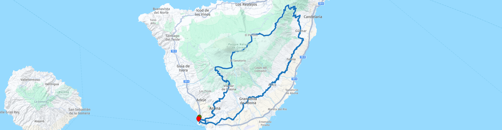
 It is a beautiful 180 km ride with beautiful winding roads and a very beautiful and varied landscape.
We enjoyed the beautiful scenery and wonderful roads and rate this route with 5 stars.
 Share this route


Animation

Verdict


Duration
7h 39m

Mode of travel
Car or motorcycle

Distance
179.38 km

Countries

 RouteXpert Review
 Our starting and ending point is at Canary Island Rides in Playa de las Américas. The route is approximately 180km and takes all day due to the many stops along the way. Don't ride this ride at night, as the roads are poorly lit.
The roads are of excellent quality, clean, and generally wide enough. There may be some stones on the road, so please be careful. There are several places along the way where you can stop to enjoy the spectacular views. Most are indicated with a blue and white road sign depicting a camera. Several are included as waypoints on this route.
The landscape is a mix of fantastic mountain scenery, barren plains with lava rocks, pine forests, and occasionally desert-like plains with cacti. There are many climbs and descents, and the roads have numerous (hairpin) bends. Experience is therefore recommended.
The route takes us along the eastern side of the island to El Teide National Park, the largest park in the Canary Islands, a geological treasure and a true natural wonder. The volcanoes, craters, vents, and lava flows form impressive and colorful formations.
Las Cañadas del Teide surprises with its diversity, disturbing, petrified lava rivers, impressive, eroded rock formations, and colossal size. In spring, however, the park resembles a flower garden full of soft and unique aromas.
Mount Teide National Park has been the setting for several films, including Star Wars, Planet of the Apes, The Fast and the Furious 6, Shawshank Redemption, and Clash of the Titans. There's a cable car ride to the summit for spectacular views, but be sure to allow extra time for this as the wait times can be long.
There are several opportunities to eat and drink along the way, but it is advisable to take enough drinking water with you, partly because of the high temperatures.
You can rent a motorcycle or car from various rental companies. You must be at least 30 years old and hold a driver's license that is at least 2 years old.
There are several types of scooters, light motorcycles, touring machines, adventure bikes, and even heavy-duty Harleys available for rent. Prices range from €40 for a 125cc scooter to €180 for a Harley-Davidson. Prices generally include the necessary insurance and unlimited mileage, helmets, jackets, and gloves. The motorcycles are often equipped with a mobile phone mount, so you can navigate this route with MRA. However, it's advisable to bring a power bank, as USB ports aren't always available on the rental motorcycles.
We rented a Harley-Davidson Road King from Canary Island Rides. This rental company also offers guided tours, or you can ride along as a passenger with the owner and discover the island's most beautiful spots.


 Links
Links  Usage
Usage Want to download this route?
You can download the route for free without MyRoute-app account. To do so, open the route and click 'save as'. Want to edit this route?
No problem, start by opening the route. Follow the tutorial and create your personal MyRoute-app account. After registration, your trial starts automatically.  Disclaimer
Use of this GPS route is at your own expense and risk. The route has been carefully composed and checked by a MyRoute-app accredited RouteXpert for use on TomTom, Garmin and MyRoute-app Navigation.
Changes may nevertheless have occurred due to changed circumstances, road diversions or seasonal closures. We therefore recommend checking each route before use.
Preferably use the route track in your navigation system. More information about the use of MyRoute-app can be found on the website under 'Community' or 'Academy'.

Canary Islands
About this region
The Canary Islands (; Spanish: Canarias, pronounced [kaˈnaɾjas]), also known informally as the Canaries, is a Spanish archipelago in the Atlantic Ocean, in a region known as Macaronesia. At their closest point to the African mainland, they are 100 kilometres (62 miles) west of Morocco. They are the southernmost of the autonomous communities of Spain, and are located in the African Tectonic Plate. The archipelago is economically and politically European, and is part of the European Union.The eight main islands are (from largest to smallest in area) Tenerife, Fuerteventura, Gran Canaria, Lanzarote, La Palma, La Gomera, El Hierro and La Graciosa. The archipelago includes many smaller islands and islets, including Alegranza, Isla de Lobos, Montaña Clara, Roque del Oeste, and Roque del Este. It also includes a number of rocks, including those of Salmor, Fasnia, Bonanza, Garachico, and Anaga. In ancient times, the island chain was often referred to as "the Fortunate Isles". The Canary Islands are the southernmost region of Spain, and the largest and most populous archipelago of Macaronesia. Because of their location, the Canary Islands have historically been considered a bridge between the four continents of Africa, North America, South America, and Europe.In 2019, the Canary Islands had a population of 2,153,389, with a density of 287.39 inhabitants per km2, making it the eighth most populous autonomous community of Spain. The population is mostly concentrated in the two capital islands: around 43% on the island of Tenerife and 40% on the island of Gran Canaria.
The Canary Islands, especially Tenerife, Gran Canaria, Fuerteventura, and Lanzarote, are a major tourist destination, with over 12 million visitors per year. This is due to their beaches, tropical to subtropical climate, and important natural attractions, especially Maspalomas in Gran Canaria, Teide National Park, and Mount Teide (a World Heritage Site) in Tenerife. Mount Teide is the highest peak in Spain and the third tallest volcano in the world, measured from its base on the ocean floor. The islands have warm summers and winters warm enough for the climate to be technically tropical at sea level. The amount of precipitation and the level of maritime moderation vary depending on location and elevation. The archipelago includes green areas as well as desert areas. The islands’ high mountains are ideal for astronomical observation, because they lie above the temperature inversion layer. As a result, the archipelago boasts two professional observatories: Teide Observatory on the island of Tenerife, and Roque de los Muchachos Observatory on the island of La Palma.In 1927, the Province of Canary Islands was split into two provinces. In 1982, the autonomous community of the Canary Islands was established. The cities of Santa Cruz de Tenerife and Las Palmas de Gran Canaria are, jointly, the capital of the islands. Those cities are also, respectively, the capitals of the provinces of Santa Cruz de Tenerife and Las Palmas. Las Palmas de Gran Canaria has been the largest city in the Canaries since 1768, except for a brief period in the 1910s. Between the 1833 territorial division of Spain and 1927, Santa Cruz de Tenerife was the sole capital of the Canary Islands. In 1927, it was ordered by decree that the capital of the Canary Islands would be shared between two cities, and this arrangement persists to the present day. The third largest city in the Canary Islands is San Cristóbal de La Laguna (a World Heritage Site) on Tenerife. This city is also home to the Consejo Consultivo de Canarias, which is the supreme consultative body of the Canary Islands.During the Age of Sail, the Canaries were the main stopover for Spanish galleons on their way to the Americas, which sailed that far south in order to catch the prevailing northeasterly trade winds.
Read more on Wikipedia
The Canary Islands, especially Tenerife, Gran Canaria, Fuerteventura, and Lanzarote, are a major tourist destination, with over 12 million visitors per year. This is due to their beaches, tropical to subtropical climate, and important natural attractions, especially Maspalomas in Gran Canaria, Teide National Park, and Mount Teide (a World Heritage Site) in Tenerife. Mount Teide is the highest peak in Spain and the third tallest volcano in the world, measured from its base on the ocean floor. The islands have warm summers and winters warm enough for the climate to be technically tropical at sea level. The amount of precipitation and the level of maritime moderation vary depending on location and elevation. The archipelago includes green areas as well as desert areas. The islands’ high mountains are ideal for astronomical observation, because they lie above the temperature inversion layer. As a result, the archipelago boasts two professional observatories: Teide Observatory on the island of Tenerife, and Roque de los Muchachos Observatory on the island of La Palma.In 1927, the Province of Canary Islands was split into two provinces. In 1982, the autonomous community of the Canary Islands was established. The cities of Santa Cruz de Tenerife and Las Palmas de Gran Canaria are, jointly, the capital of the islands. Those cities are also, respectively, the capitals of the provinces of Santa Cruz de Tenerife and Las Palmas. Las Palmas de Gran Canaria has been the largest city in the Canaries since 1768, except for a brief period in the 1910s. Between the 1833 territorial division of Spain and 1927, Santa Cruz de Tenerife was the sole capital of the Canary Islands. In 1927, it was ordered by decree that the capital of the Canary Islands would be shared between two cities, and this arrangement persists to the present day. The third largest city in the Canary Islands is San Cristóbal de La Laguna (a World Heritage Site) on Tenerife. This city is also home to the Consejo Consultivo de Canarias, which is the supreme consultative body of the Canary Islands.During the Age of Sail, the Canaries were the main stopover for Spanish galleons on their way to the Americas, which sailed that far south in order to catch the prevailing northeasterly trade winds.
View region
 Statistics
  8
8Amount of RX reviews (Canary Islands)
 17315
17315Amount of visitors (Canary Islands)
 395
395Amount of downloads (Canary Islands)
 Route Collections in this region
 Exploring the magnificent roads of Gran Canaria in three days
Nog een weekje vakantie tegoed? En het snertweer zat? Op vier uur vliegen is het, in tegenstelling tot het wisselvallige Nederlandse weer, altijd zomer. En Gran Canaria kan dan wel bekend staan om de massa's zonaanbidders, het blijkt ook een waar walhalla voor de motorrijder!
Deze drie routes zijn prima in één weekend of midweek te rijden. Ze brengen je naar alle hoeken van het eiland waar het maar enigszins interessant is om te rijden. En laten we eerlijk zijn, dat is bijna het hele eiland! Laat je overweldigen door de fantastische krullende wegen, voorzien van strak asfalt, die over het eiland zijn aangelegd, laat je verrassen door de verborgen schatten die aan het massatoerisme voorbij gaan.
Op het eiland zijn meerdere verhuurders van motoren aanwezig waaronder Motor Rental Bike en Pic Y Poc. Voor het meest actuele aanbod en prijzen schiet je een zoekopdracht in bij Google, dan ben je vrijwel zeker dat de data niet verouderd is.
Per route worden in de review enkele bezienswaardigheden besproken. Deze vertellen vaak iets over de geschiedenis van het gebied waarin je rijdt. Leuke weetjes, best leerzaam. Het staat je geheel vrij om deze bezienswaardigheden te bezoeken, je kunt uiteraard ook je eigen interessante punten bepalen.
Maar het belangrijkste waar je waarschijnlijk voor bent afgereisd naar dit gebied, is het geweldige rijden en het schitterende weer. En zoals hierboven al is gezegd, je bevindt je in een waar motorparadijs waarin het fantastisch sturen is!
De routes van deze collectie:
Roundtour Gran Canaria day 1 West - 223km
Roundtour Gran Canaria day 2 North-East - 191km
Roundtour Gran Canaria day 3 South - 245km
Heel veel plezier bij het rijden van deze routes!
View Route Collection