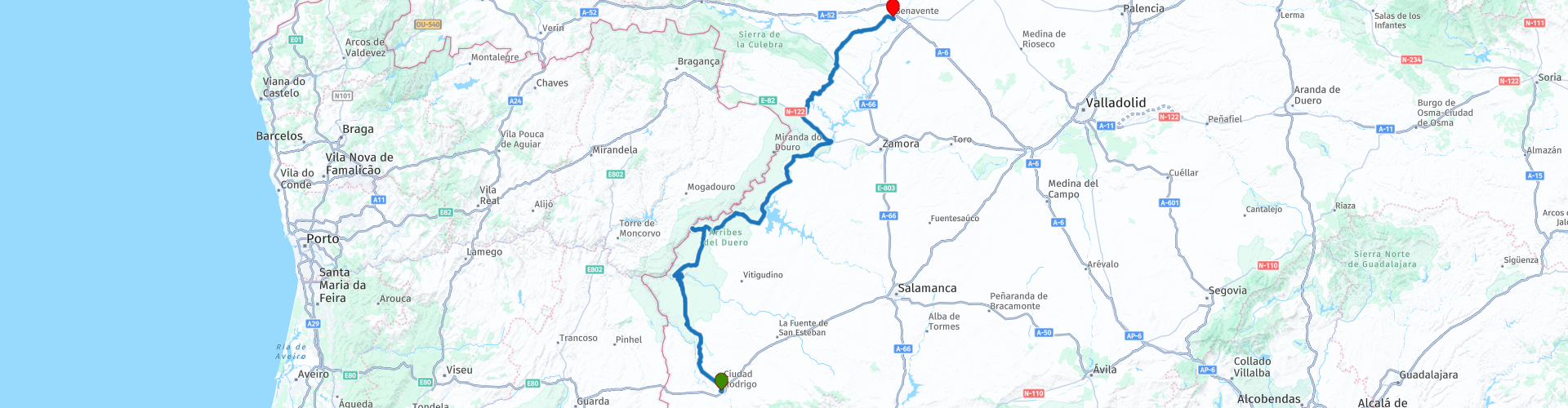
Castilla y Leon Plains Ciudad Rodrigo to Benavente

This route was brought to you by:
RouteXpert CorsaroG
Last edit: 14-12-2025
 Route Summary
 The middle of the day is defined by two signature themes: canyon exposure and hydro scale. Mirador del Fraile delivers the classic Arribes perspective—tight bends of the Duero cut into sheer rock—before the ride hits a rare “on the structure” moment at the Presa de Almendra crest crossing over the Tormes valley. The engineering chapter continues at Mirador del Salto de Villalcampo, where dam, spillway and gorge walls combine into a single, photo-ready scene. The finish at Parador de Benavente closes the arc with the Torre del Caracol: a Renaissance tower-palace remnant that bookends the day’s frontier castles with a very different kind of authority.
Overall this is a 4 star day: strong narrative, high variety, and multiple “big feature” stops that earn their place
 Share this route


Animation

Verdict


Duration
7h 56m

Mode of travel
Car or motorcycle

Distance
290.27 km

Countries

 RouteXpert Review
 A short run west brings the first “story stop” into focus. San Felices de los Gallegos sits on La Raya like a marker pin for medieval geopolitics: granite underfoot, a dominating keep on top, and wall-lines that still direct movement through narrow streets and controlled gates. Tradition links major strengthening to Portugal’s King Dinis, and the broader context is shaped by the Treaty of Alcañices (1297), which stabilised much of the modern boundary in this sector. It’s a place where the defensive plan still reads clearly: lookouts to command distance, walls to slow approach, tight lanes to funnel attack, and wide views over dry-stone fields and rolling frontier country.
Then the route changes register at Cachón del Camaces. This isn’t a “tour-bus waterfall”; it’s the kind of local, seasonal feature that makes a ride feel discovered rather than curated. The Camaces steps down over granite shelves into small plunge pools—lively after rain and in wetter months, reduced to thin runs in dry periods when polished channels and rock texture become the headline. It’s an ideal contrast stop because it anchors the idea of “river” as something intimate and natural before the day pivots to rivers as infrastructure.
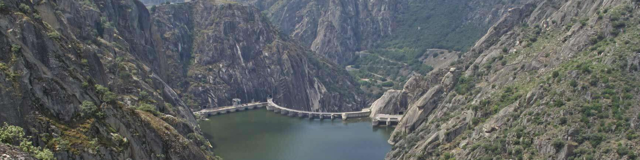
From Saucelle, the landscape flips. The Arribes are not gradual; they arrive like a rupture. Mirador del Fraile is the day’s canyon signature: a steel cantilever projecting about 12.8 m over the void with roughly 25 m² of deck, hanging around 300 m above the water. The glass floor panel intensifies the straight-down sensation, and the view naturally frames the Embalse/Presa de Aldeadávila, tight bends and sheer granite walls. The canyon microclimate often produces strong thermals, and the stop is noted for watching soaring birds—vultures and other raptors—using the updrafts along the cliff line.
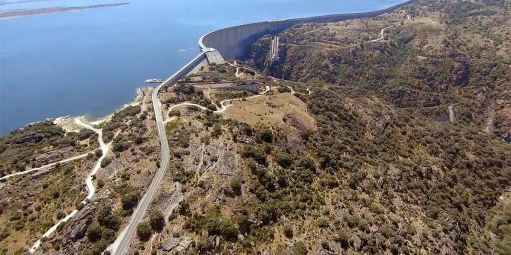
After lunch, the engineering story becomes physical. Mirador de la Presa de Almendra is one of those rare moments where infrastructure isn’t just beside the road—it is the road. The crest-level crossing closes the deep Tormes valley to form the Embalse de Almendra, and the ride runs directly along the dam with big-drop gorge views and long reservoir sightlines. The impression is not subtle: the valley pinches tight, the structure asserts itself, and the scale is obvious even in motion. It’s a landmark of the 20th-century hydro-engineering era that reshaped river valleys in western Castile.
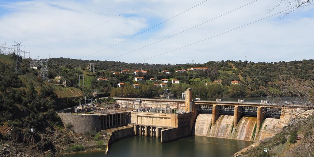
If Almendra is about scale, Villalcampo is about composition and detail. The Mirador del Salto de Villalcampo looks onto a gravity dam about 50 m high with a crest of roughly 315 m, inaugurated on 1949-07-27 as part of the Saltos del Duero programme. Two power stations operate here—Villalcampo I (98.76 MW) and Villalcampo II (119.05 MW), total installed capacity 217.81 MW—making it a compact case study in how granite constrictions became power sites. The viewpoint frames dam face, spillway zone and gorge walls in one shot, perfect for a “what you’re looking at” explanation and a clean photo.
The final act turns back to big-sky plains. Bar de Ángel in Fonfría works as a classic rural reset: a simple café-bar hub in cereal-country with wide horizons, long field boundaries and scattered farm buildings. The stop’s little navigation detail—turn left for coffee, otherwise turn right onto ZA-902—captures the day’s practical rhythm: the route keeps moving, but the best days still include small, human pauses in places that feel properly local.
The finish is a strong bookend. Parador de Benavente is centred on the Torre del Caracol, the lone major remnant of the former Pimentel fortress. The tower is famed for its Mudéjar coffered ceiling, brought from the disappeared convent of San Román del Valle, and the whole site was incorporated into the Parador in 1972. After frontier castles, canyon voids and megadam crossings, the rider ends with a Renaissance tower that feels like a reward: less about defence now, more about craftsmanship, prestige and the long memory of place.
Expect rapid shifts in road character: tight village entries, fast open stretches and exposed canyon edges. In the Arribes sector, crosswinds and sudden gusts can be significant near viewpoints and dam crests; keep a relaxed grip and avoid lingering alongside drop-offs. In wet months watch for damp leaf litter and mossy stone at pull-ins; in summer, heat and fatigue make break spacing important. Wildlife and livestock can appear without warning on rural plains, especially late day. Pace the day around the main stops and assume occasional enforcement on straighter approaches into towns.
 Links
Links  Usage
Usage Want to download this route?
You can download the route for free without MyRoute-app account. To do so, open the route and click 'save as'. Want to edit this route?
No problem, start by opening the route. Follow the tutorial and create your personal MyRoute-app account. After registration, your trial starts automatically.  Disclaimer
Use of this GPS route is at your own expense and risk. The route has been carefully composed and checked by a MyRoute-app accredited RouteXpert for use on TomTom, Garmin and MyRoute-app Navigation.
Changes may nevertheless have occurred due to changed circumstances, road diversions or seasonal closures. We therefore recommend checking each route before use.
Preferably use the route track in your navigation system. More information about the use of MyRoute-app can be found on the website under 'Community' or 'Academy'.

Castile and León
About this region
Castile and León (UK: , US: ; Spanish: Castilla y León [kasˈtiʎa i leˈon] (listen); Leonese: Castiella y Llión [kasˈtjeʎa i ʎiˈoŋ]; Galician: Castela e León [kasˈtɛlɐ ɪ leˈoŋ]) is an autonomous community in north-western Spain.
It was created in 1983. Formed by the provinces of Ávila, Burgos, León, Palencia, Salamanca, Segovia, Soria, Valladolid and Zamora, it is the largest autonomous community in Spain in terms of area, covering 94,222 km2. It is however sparsely populated, with a population density below 30/km2. While a capital has not been explicitly declared, the seats of the executive and legislative powers are set in Valladolid by law and for all purposes that city (also the most populated municipality) serves as de facto regional capital.
Castile and León is a landlocked region, bordered by Portugal as well as by the Spanish autonomous communities of Galicia, Asturias, Cantabria, the Basque Country, La Rioja, Aragon, Castilla–La Mancha, the Community of Madrid and Extremadura. Chiefly comprising the northern half of the Inner Plateau, it is surrounded by mountain barriers (the Picos de Europa to the North, the Sistema Central to the South and the Sistema Ibérico to the East) and it is drained by the Douro River, flowing west toward the Atlantic Ocean.
The region contains eight World Heritage Sites. UNESCO recognizes the Cortes of León of 1188 as the cradle of worldwide parliamentarism.
Read more on Wikipedia
It was created in 1983. Formed by the provinces of Ávila, Burgos, León, Palencia, Salamanca, Segovia, Soria, Valladolid and Zamora, it is the largest autonomous community in Spain in terms of area, covering 94,222 km2. It is however sparsely populated, with a population density below 30/km2. While a capital has not been explicitly declared, the seats of the executive and legislative powers are set in Valladolid by law and for all purposes that city (also the most populated municipality) serves as de facto regional capital.
Castile and León is a landlocked region, bordered by Portugal as well as by the Spanish autonomous communities of Galicia, Asturias, Cantabria, the Basque Country, La Rioja, Aragon, Castilla–La Mancha, the Community of Madrid and Extremadura. Chiefly comprising the northern half of the Inner Plateau, it is surrounded by mountain barriers (the Picos de Europa to the North, the Sistema Central to the South and the Sistema Ibérico to the East) and it is drained by the Douro River, flowing west toward the Atlantic Ocean.
The region contains eight World Heritage Sites. UNESCO recognizes the Cortes of León of 1188 as the cradle of worldwide parliamentarism.
View region
 Statistics
  29
29Amount of RX reviews (Castile and León)
 14369
14369Amount of visitors (Castile and León)
 2523
2523Amount of downloads (Castile and León)
 Route Collections in this region
 Three tours in and around Picos de Europa Northern Spain
The Picos de Europa is a mountainous area in northern Spain, next to the Basque Country. In the middle is the village of Posada de Valdeon, which cannot be reached by motorbike from the north: you have to drive around the Picos via Potes or Sames. We stayed overnight in Posada de Valdeon in Hostal Casa Abascal. A great hotel with breakfast option. You can eat in a restaurant in the village with usually a choice of two menus.
There are all kinds of nature reserves around the Picos. These three routes take you through some of them. There are gorges to see, viewpoints, reservoirs and you can walk more than fine. If you like walking, bring your walking shoes.
But we come to ride and it's going great. Excellent roads with the occasional piece of unpaved so that you do not have to detour far for another attraction. You can eat delicious food and the people are very nice and hospitable. And because the route to Lourdes goes above the Picos, there are also pilgrimage sites and very beautiful churches and monasteries. The most beautiful thing in this area is the nature: breathtakingly beautiful with wild animals, rugged mountains and wild rivers.
All in all, you can spend at least 4 days here if you take a day of rest or go for a walk.
View Route Collection
A 4 day tour in Spain from Bilbao to Cartagena
With a starting point just south of Bilbao, this 1,300 km tour is easy to connect to from the French border or Santander. The tour travels through some of Spain's most spectacular landscapes and visits among other things, the windmills of La Mancha, made famous in the books by Miguel de Cervantes and his character Don Quixote. The end of this 4 day tour is at Cartagena on the Mediterranean's Costa Cálida, a wonderful city that's alive with culture, history and gastronomy.
View Route Collection