Hasta la Vista from Cehegin

This route was brought to you by:
RouteXpert Jan Koelstra - Senior Rx
Last edit: 21-08-2025
 Route Summary
 Routes under this umbrella have in common that they all come closer to the Spanish sun, where along the way there is a reunion of (almost) forgotten impressions and memories.
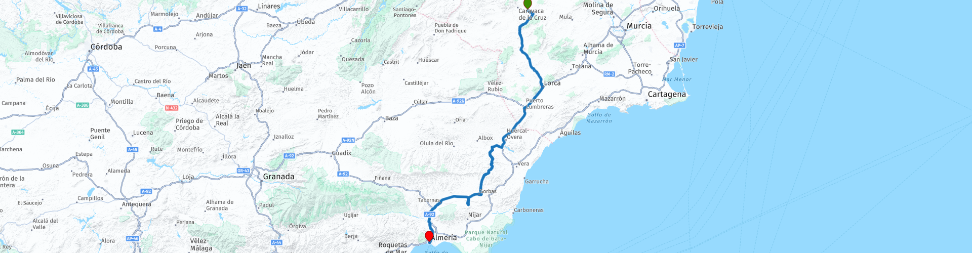
This time the trip goes from Cehegín, part of the Bullas wine region, to the Mediterranean port of Almeria, where ferries depart for Morocco and Algeria.
Thanks to the gradual transition to more sunshine, milder winters, less stress, and a more affordable lifestyle. But also honoring the desire for Mediterranean cuisine, the outdoors, and the friendliness and hospitality of the people. Afterwards, you'll feel that "deja" feeling again, and that's definitely worth 5 stars.
 Share this route


Animation

Verdict


Duration
5h 24m

Mode of travel
Car or motorcycle

Distance
220.67 km

Countries

 RouteXpert Review
 Cehegín is a charming and lively village with a wide variety of rural houses and churches. Various routes have been established: the Route of the Churches, with enclaves as impressive as the Renaissance church of Santa María Magdalena and the hermitage of the Immaculate Conception, both declared national monuments.
The city center is considered one of the best preserved in the region. It's the oldest and most traditional part of the city: cluttered, narrow streets and alleys, dotted with a few passageways, enormous squares, and monuments. There are shops, several good restaurants, and cozy bars. After refueling, head south towards Lorca.
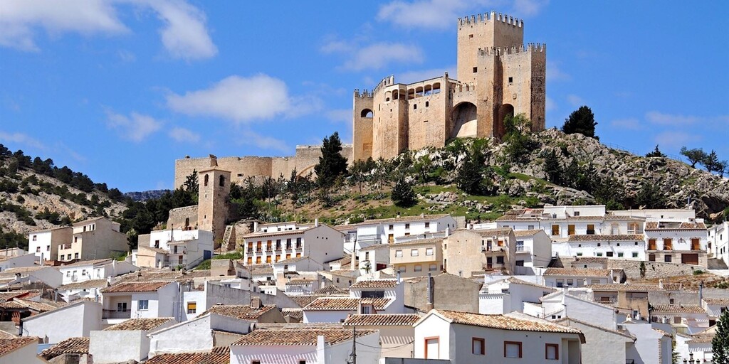
Lorca boasts an intriguing 10th-century castle, which houses a Parador hotel, and an impressive Plaza de España. The city is known as the "Baroque City" because of its numerous Baroque monuments in its historic center. In 2011, the city was severely affected by two earthquakes, killing nine people and causing (severe) damage to many buildings.
Above the old town, built into the mountainside, stands the castle. It is one of the largest fortifications in Spain, measuring 640 meters long and 120 meters wide! The defensive walls are of Moorish origin, but the two towers were built by the Christians. From the castle, you have an incredible view of the city. The centerpiece of the old town is the (renovated) synagogue, part of which is buried underground.
Lorca had its back to the river, but the Manterola pedestrian bridge came to the rescue. The bridge connects the old town with the new town, situated further afield. Around the beautiful little square, Plaza de España, are several noteworthy buildings, including the 16th/17th-century San Patricio Cathedral with its beautiful Baroque portal and the Casa Consistorial, the town hall from the 17th/18th century. The Pósito de Panaderos (Peasant Farmhouse) was used for the storage and distribution of grain. The square boasts numerous local bars, where you can easily find a spot for a coffee.
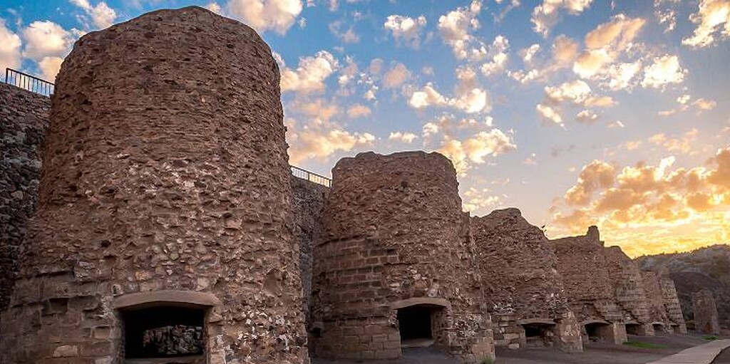
Sorbas is an exceptionally impressive village. It is situated on a small plateau above the Río Aguas, and its white houses practically hang over the ravine, above the river Aguas. Among the maze of narrow and steep streets of Moorish origin are several viewpoints—Porche, Castillo, Calvario, and Torreta—from which you can admire the hanging houses and the beautiful surrounding landscape. The town boasts one of the largest gypsum mines in the world. From the ports of Garrucha and Carboneras, it is exported worldwide. Sorbas is famous for its pottery, made from red clay sourced locally. In the central square of Sorbas, you will find the most important monuments: the Santa María Church, built in the 16th century on top of an old mosque and featuring many Mudéjar, Baroque, and Neoclassical elements; the Town Hall; the houses of the Duke of Alba, the Duke of Valois, and the Duke of Marqués del Carpio; and the Villaespesa Theatre.
Just a few kilometers outside Sorbas, the Karst and Yesos de Sorbas Nature Reserve, covering over 2,000 hectares, is one of Almeria's biggest tourist attractions. This is no wonder, as it's the best example of a karst formation in Spain and one of the most important in Europe. This geological gem, a stalactite formation in a gypsum plateau, is a product of rainwater falling over thousands of years.
Lucainena de las Torre, a great place for lunch, has just 600 inhabitants and lies at the foot of the Sierra Alhamila. This small, beautiful mountain village was founded under the rule of the Roman Empire. The Moors gave it a defensive wall and seven towers to protect it from incursions. In 1505, the first church was built on the ruins of the former mosque. After the Moors left, the village remained uninhabited until the 16th century, when 19 settlers arrived to settle it. The village grew until it had a population of 2,455 in 1900. In the 19th century, much of the surrounding land was reclaimed from the old feudal masters and the church and given to the local population. After this, agriculture and mining flourished, resulting in a thriving industry in the area thanks to newly built clothing and soap factories, wind and watermills, potteries, and distilleries.
The pristine whitewashed walls are dotted with colorful flowerpots, which the locals take great care of year-round. As you walk through the village center, be sure to look out for the 18th-century church and the old washhouse, where villagers gathered to wash their clothes and drink fresh water.
Mirador del Garruchete, offering stunning mountain views. Mirador del Poyo de la Cruz is a well-maintained lookout point with benches where you can enjoy the panoramic view for hours. East of the village lies the famous Juagarí Ravine, home to hot springs with numerous stories of miracles.
Tabernas is an elongated Roman town with a Moorish appearance, surmounted by the ruins of a 14th-century Moorish castle, which was the second most important in the province after Almeria. The 15th-century Mudéjar church is also worth a visit.
Would you also like to take a look at the desert? About 7 km from Tabernas lies the last remaining (semi-)desert in Europe. A bone-dry area of 280 km² with year-round sunshine and the least rainfall in all of Europe! Only a few days per year see heavy downpours. Temperatures here range from -5°C to 48°C. This has resulted in a spectacular landscape with impressive rock formations, ravines, steep gullies, barren slopes with ochre hues, and the occasional palm tree, cacti, and succulent. The desert is dotted with numerous dry riverbeds (ramblas), which create a unique microclimate that is more humid than anywhere else in this otherwise parched landscape. Here you'll see reeds, oleanders, and tamarisks. There are also numerous springs, but the water they produce has a high salt content and is not suitable for drinking. This rugged landscape may not seem like it has much wildlife, but along the edges of the seasonal rivers there are many reptiles and birds, including eagles.
Filmmakers have long been drawn to the landscape, with its similar appearance to the North American Wild West. Many Spaghetti Westerns, such as Lawrence of Arabis and A Fistful of Dollars, have been filmed there in the last century. More recently, Game of Thrones was filmed in the desert gorges known as the Rambla del Cautivo and La Rambla del Buho near the village of Tabernas. Several film sets can be visited here: Mini-Holywood, the smaller Texas Hollywood, 2 km from Tabernas, and Western Leone nearby.
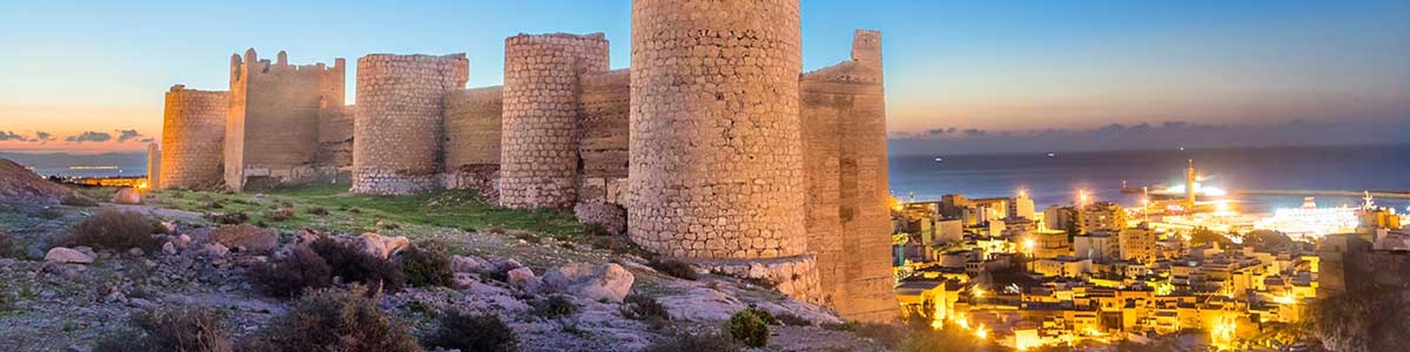
And you're nearing your destination. Almeria, the easternmost capital of Andalusia, is situated at the foot of a mountain range crowned by the magnificent Alcazaba. The city enjoys a warm climate in both summer and winter. At first, you might think Almería is "just" a large port. But upon closer inspection, it's a pleasant place to stroll through. With its white houses and flat roofs, surrounded by an ochre-colored desert, the city is reminiscent of North Africa.
Almeria was already an important Mediterranean port in Roman times as "Portus Magnus." It was also an important port under the Caliphate of Cordoba, exporting silk, cotton, and brocade from the port. Almería then had its "golden age." Ferries to Morocco and Algeria now depart from the port. Stroll along the seafront Parque Nicolás Salmerón (the oldest park in the region and city) with its palm trees, fountains, and gardens. Here, djellaba-clad men gather to drink their mint tea. They work in the surrounding greenhouses that have made Almería so prosperous. The region is a leader in agriculture, and the entire area is surrounded by horticultural greenhouses.
The city's sights include the Alcazaba, the cathedral, the Plaza de la Constitución, the Santiago Church and a Moorish underground water reservoir (aljibe) and the underground shelters (refugios) of Almería, built during the Spanish Civil War.
 Links
Links  Usage
Usage Want to download this route?
You can download the route for free without MyRoute-app account. To do so, open the route and click 'save as'. Want to edit this route?
No problem, start by opening the route. Follow the tutorial and create your personal MyRoute-app account. After registration, your trial starts automatically.  Disclaimer
Use of this GPS route is at your own expense and risk. The route has been carefully composed and checked by a MyRoute-app accredited RouteXpert for use on TomTom, Garmin and MyRoute-app Navigation.
Changes may nevertheless have occurred due to changed circumstances, road diversions or seasonal closures. We therefore recommend checking each route before use.
Preferably use the route track in your navigation system. More information about the use of MyRoute-app can be found on the website under 'Community' or 'Academy'.

Murcia
About this region
The Region of Murcia (, US also ; Spanish: Región de Murcia [reˈxjon de ˈmuɾθja]), is an autonomous community of Spain located in the southeast part of the Iberian Peninsula, on the Mediterranean coast. The region is centered on a historical region of the same name in what is now southeastern Spain. It is heir to the ancient Kingdom of Murcia, which traditionally included, as a bi-provincial region, the provinces of Albacete and Murcia. During the transition to democracy (la Transición), Albacete became part of Castilla–La Mancha. The region is 11,313 km2 (4,368 sq mi) in area and had a population of 1,511,251 as at the start of 2020. About one-third of its population lives in the capital, Murcia. At 2,014 m (6,608 ft), the region's highest point is Los Obispos Peak in the Massif of Revolcadores.The region is bordered by Andalusia (the provinces of Almería and Granada), Castile La Mancha (the province of Albacete, which until 1980 was a part of Murcia), the Valencian Community (province of Alicante), and the Mediterranean Sea. The autonomous community is a single province. The city of Murcia is the capital of the region and the seat of the regional government, but the legislature, known as the Regional Assembly of Murcia, is located in Cartagena. The region is subdivided into municipalities.The region is among Europe's largest producers of fruits, vegetables, and flowers, with important vineyards in the municipalities of Jumilla, Bullas, and Yecla that produce wines of Denominación de origen. It also has an important tourism sector concentrated on its Mediterranean coastline, which features the Mar Menor saltwater lagoon. Industries include the petrochemical and energy sector (centered in Cartagena) and food production. Because of Murcia's warm climate, the region's long growing season is suitable for agriculture; however, rainfall is low. As a result, in addition to the water needed for crops, there are increasing pressures related to the booming tourist industry. Water is supplied by the Segura River and, since the 1970s, by the Tagus-Segura Water Transfer, a major civil-engineering project that brings water from the Tagus River into the Segura under environmental and sustainability restraints.
Notable features of the region's extensive cultural heritage include 72 cave art ensembles, which are part of the rock art of the Iberian Mediterranean Basin, a World Heritage Site. Other culturally significant features include the Council of Wise Men of the plain of Murcia and the tamboradas (drumming processions) of Moratalla and Mula, which were declared intangible cultural heritage by UNESCO. The region is also the home of Caravaca de la Cruz, a holy city in the Catholic Church that celebrates the Perpetual Jubilee every seven years in the Santuario de la Vera Cruz.
Read more on Wikipedia
Notable features of the region's extensive cultural heritage include 72 cave art ensembles, which are part of the rock art of the Iberian Mediterranean Basin, a World Heritage Site. Other culturally significant features include the Council of Wise Men of the plain of Murcia and the tamboradas (drumming processions) of Moratalla and Mula, which were declared intangible cultural heritage by UNESCO. The region is also the home of Caravaca de la Cruz, a holy city in the Catholic Church that celebrates the Perpetual Jubilee every seven years in the Santuario de la Vera Cruz.
View region
 Statistics
  4
4Amount of RX reviews (Murcia)
 15415
15415Amount of visitors (Murcia)
 241
241Amount of downloads (Murcia)
 Route Collections in this region
 A 4 day tour in Spain from Bilbao to Cartagena
With a starting point just south of Bilbao, this 1,300 km tour is easy to connect to from the French border or Santander. The tour travels through some of Spain's most spectacular landscapes and visits among other things, the windmills of La Mancha, made famous in the books by Miguel de Cervantes and his character Don Quixote. The end of this 4 day tour is at Cartagena on the Mediterranean's Costa Cálida, a wonderful city that's alive with culture, history and gastronomy.
View Route Collection
Hasta la Vista
"Hasta la vista" is a Spanish expression that literally translates to "until we see you." It's used as a farewell greeting and means something like "see you later," "see you later," or "farewell." The routes under the Hasta la Vista umbrella all have in common that they head towards the Spanish sun, and along the way you'll encounter (almost) forgotten sights, refreshing your memories and reviving the joy of it all.
This collection consists of 16 routes that all share one thing in common: they all face south, heading towards the sunny south and then all the way to the Costa del Sol. The first route begins in the northernmost tip of the cool Netherlands near Moddergat, and the last route ends in the sunny south of Spain near Almeria.
This collection consists of 16 routes that all share one thing in common: they all face south, heading towards the sunny south and then all the way to the Costa del Sol. The first route begins in the northernmost tip of the cool Netherlands near Moddergat, and the last route ends in the sunny south of Spain near Almeria.
View Route Collection