MTG2 16 French Alpes La Grave Briancon Barcelonnette

This route was brought to you by:
RouteXpert René Plücken (MRA Master)
Last edit: 12-02-2021
 Route Summary
 climate. It is not for nothing that you see so many motorcyclists there. My previous series of routes in France were based on the route descriptions from the Motortourgids France part 1 made by Bert Loorbach.
This route comes from Motortourgids France part 2 and the original name is "The Alps Directions 5: from the Col de Lautaret to the Alpes de Maritimes".
In Motorbike guide France part 2 a difference has been made between approach routes and trips in a certain area. The approach routes can also be used in combination with the routes from Motortourgids France part 1
The routes are sometimes slightly adjusted based on the tips that Bert Loorbach gives in his description, or because of a different place to spend the night, or to achieve the minimum length of 2 hours for the MRA Library. For each route there is a more detailed description in the review, including options to stay overnight or places of interest en route, which are also indicated with a POI and if possible with a short description
The route is made suitable for Garmin, TomTom, Harley-Davidson BoomBox 2019 and Navigation App, can be downloaded for free and without My-Route-app registration. To do this, first click on the 'Use route' button and then on 'Save as'.
 Share this route


Animation

Verdict


Duration
5h 28m

Mode of travel
Car or motorcycle

Distance
276.56 km

Countries

 RouteXpert Review
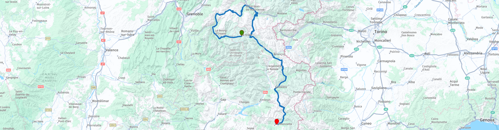
 This route has many passes with beautiful curves and the necessary hairpins. We go up and down the mountain, so we have wonderful steering, with beautiful panoramas along the way. This route is in line with the previous route so we leave La Grave.
The original route is only 135km away, so I tied it up with some beautiful winding sections, along a few azure blue lakes and once again the Col du Galibier as a bonus, simply because it is possible.
So instead of driving east to the Col du Lautaret, we drive west. If you want to drive the original route, go straight to RP12.
We drive on the D1091 along the lake "Lac du Chambon" (RP2), at Rochetaillée we turn right and continue on the D526 to the next azure blue Lac du Verney (RP4). The road winds further north along the small river Eau d'Olle, you drive through the woods and along rocky walls with beautiful panoramas. The roads are varied with beautiful curves and occasionally also a few delightful hairpin bends such as RP5.
At RP6 a short stop is planned to take pictures at the dam in the lake "Lac de Grand Maison". Then we continue to the Col de la Croix de Fer (RP7) where we also stop to enjoy the view. After this comes a very winding part and the roads are very narrow but of good quality. The view over the Alps is phenomenal.
We continue on to St. Michel-de-Mauríenne (RP9) and take the D902, cross the track, the river Arc and the new highway to be able to enjoy the curves again. This is the same as the previous route until the Col du Lautaret.
Via the Col du Télégraphe (RP10) we arrive at Valloire, here there are a few less bends in the road, so just a step back, for the great last sensation of this tour Le Col du Galíbier! This topper of the Tour de France is also a topper for motorized turn knights and the tires and brake discs do not get time to cool down. No time to enjoy the landscape, we will do that upstairs, so definitely stop at RP11 to enjoy the great view at 2645 meters.
We now arrive at the original starting point of this route, the Col du Lautaret (RP12). We drive the D1091 (N91) towards Briançon, this road is very boring compared to the first stage and we walk through a fairly open valley of the Guisane and on the right is the Massif des Ecrins. Briançon (RP13) is the highest city in Europe and lies at 1321 meters in a strategic location near the Italian border. Because of this the city received fortifications from the time of the Ketten and then the Romans. So if you like Forts, this is a suitable city to stop and see a few.
After Briançon it is time for smaller roads again. After a fairly straight stretch, the D902 takes you to the top of the Col de L'Izoard, where a lunch is planned at RP14 at the Restaurant Refugé Napoléon.
This Col de L'Izoard has a respectable 2360 meters on offer and is also the gateway to the Queyras Natural Park. Here the mountains change from richly covered with grass to bare.
The D902 turns left at Guillestre and climbs steadily to the Col du Vars (2109 m). Alpine meadows with blocks of sandstone define the landscape. Via the D900 we descend again to the end point in Barcelonnette.
This route is worth 5 ***** stars because of the beautiful Alpine roads, beautiful villages and towns along the way and it is located
Another summary of the Cols we drove;
RP7 The Col de la Croix-de-Fer is a mountain pass in the French Alps. This mountain pass is located at an altitude of 2068 meters and is located in the heart of the Grandes Rousses massif, at a bird's eye view, 2500 meters from the Col du Glandon. The mountain pass serves as a passage between the departments of Savoie and Isère.
RP10 The Col du Télégraphe (1566m) is a mountain pass in the French Alps. The mountain pass is best known for cycling stages in the Tour de France.
RP11 The Col du Galibier is a mountain pass (2642m) in the French Alps. It connects Saint-Michel-de-Maurienne and Briançon via the Col du Télégraphe in the north and the Col du Lautaret in the south. The pass is closed in the winter.
RP12 The Col du Lautaret is a mountain pass in the French Alps. Height: 2,058 m (start of the original route)
RP15 The Col d'Izoard is a mountain pass (2360 m) located in the French Alps. The pass is best known for cycling stages in the Tour de France. Characteristic of the pass is the bare, rocky part just before the summit on the south side, which is called Casse Déserte
RP16 Col de la Platrière is a high mountain pass at an altitude of 2,220 m (7,283 ft) above sea level, located in the Alps in the Hautes-Alpes department in France. The road across the pass is asphalted and narrow. It is called D902. It contains hairpins and is pretty steep. The pass is two and a half kilometers south of the Col d'Izoard. The climb is often climbed on the Tour de France route
RP19 The Col de Vars is a 2109 meter high mountain pass in the French Alps that forms the connection between Saint-Paul-sur-Ubaye and Vars. The pass height forms the border between the departments of Hautes-Alpes and Alpes-de-Haute-Provence. The pass is usually open for traffic throughout the year.


 Links
Links  Usage
Usage Want to download this route?
You can download the route for free without MyRoute-app account. To do so, open the route and click 'save as'. Want to edit this route?
No problem, start by opening the route. Follow the tutorial and create your personal MyRoute-app account. After registration, your trial starts automatically.  Disclaimer
Use of this GPS route is at your own expense and risk. The route has been carefully composed and checked by a MyRoute-app accredited RouteXpert for use on TomTom, Garmin and MyRoute-app Navigation.
Changes may nevertheless have occurred due to changed circumstances, road diversions or seasonal closures. We therefore recommend checking each route before use.
Preferably use the route track in your navigation system. More information about the use of MyRoute-app can be found on the website under 'Community' or 'Academy'.