Dauphine region from Pont en Royans

This route was brought to you by:
RouteXpert Jan Koelstra (jan cabrio)
Last edit: 25-06-2025
 Route Summary
 Some are well-known, such as the city of Grenoble and Vizille. Others are less visible, such as the picturesque villages of Saint-Geoire-en-Valdaine, Saint-Pierre-de-Chartreuse and Saint-Hugues-de-Chartreuse in the Chartreuse Natural Park, but they are all exceptional for their cultural heritage, their panoramas, their hidden treasures. The best thing: they are all easy to visit all year round thanks to free guided tours!
The unique area of the regional parks is not only characterized by the flora and fauna of the park, but also by the archaeology, the built heritage, the landscape, the mountain villages, the culture, the customs. That is why this exploration tour, which also takes you along exciting roads, gets a five-star rating.
 Share this route


Animation

Verdict


Duration
8h 39m

Mode of travel
Car or motorcycle

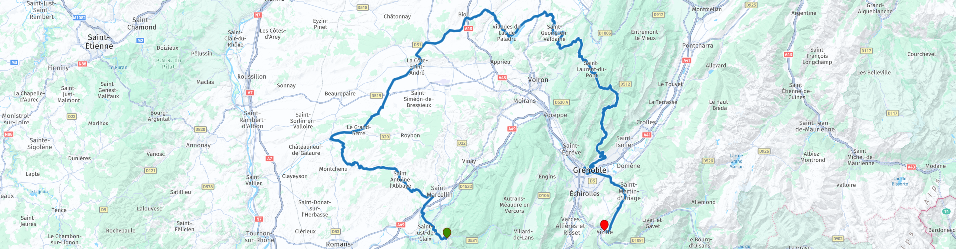
Distance
210.41 km

Countries

 RouteXpert Review
 The province offers a varied landscape between the Alpine peaks of the Haut-Dauphiné, the Pre-Alps, the Balconies of the Dauphiné or those of Valentinois, which have a more Mediterranean character.
This tour takes you through the western part of the Dauphiné, starting in the picturesque Pont-en-Royans and ending in Vizille, the last court of the Dauphiné. You will largely pass through two nature parks. In the Vercors Regional Nature Park, you can admire the gorges de la Bourne; or the charming village of Pont-en-Royans, where the historic houses seem to hang above the river. Admire the unspoilt nature and the remarkable architecture in the Chartreuse Regional Nature Park. It is a region for bon vivants, with the emphasis on a few specialities: Chartreuse, the famous plant liqueur, the inevitable gratin dauphinois or the ravioli from Dauphiné.
The village of Pont-en-Royans is located in the Vercors Regional Natural Park. The village is known for its hanging houses over the Bourne. These unusually overhanging houses give the village a charming and picturesque appearance. The best view of these houses can be had from the specially constructed plateau, which is usually well filled with tourists in the summer months. The wooden balconies and the brightly painted houses seem to come straight from the Middle Ages. The rest of the village consists of small narrow streets that are partly too narrow for a car. You can refuel in Saint-Marcellin at Leclerc in the Centre Commercial.
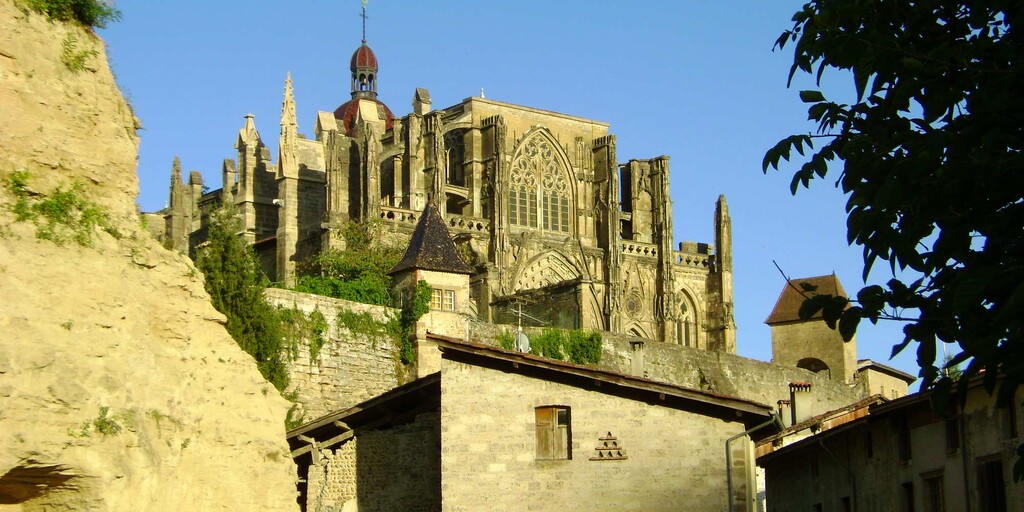
The restoration of the old buildings in St.-Antoine l'Abbaye makes the ancient village even more charming. The surroundings, densely packed with trees from the Chambaran forest, look just as lovely. And amidst the houses rises the abbey complex of St.-Antoine in 'molasse' stone. In 1095, Pope Urban II decided to establish the order of the Antonites. They were to dedicate themselves to caring for the sick. This order was given a Gothic abbey in St.-Antoine. The choir enclosure dates from the 12th century. The church treasure is particularly impressive: tapestries by Aubusson and a 16th-century ivory Christ are among the highlights.
Saint-Antoine-l'Abbaye is one of the Most Beautiful Villages of France. The facades of the houses, the winding streets, the old market hall, the colorful roofs, the large houses that contrast with the half-timbered houses, offer a fantastic journey back to the Middle Ages.
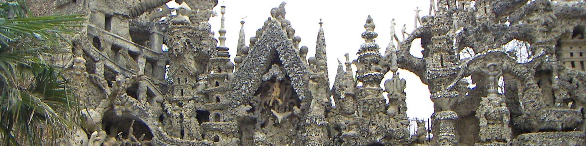
The Palais Idéal du Facteur Cheval is the work of a simple and modest man. In 1879, postman Ferdinand Cheval (1836-1924) stumbled upon a strange stone that made him want to build an imaginary palace in his garden. 33 years later, in 1912, the building became a reality. The idea for the building, later called the 'Palais Idéal du Facteur Cheval', came about during his daily rounds. Inspired by the illustrated postcards and magazines he handed out, Ferdinand Cheval collected stones in the countryside (almost) every day and then placed them in his lush garden.
Today, the story of Facteur Cheval's Palais Idéal lives on thanks to the many annual visitors, but also thanks to the film (2018) by French director Nils Tavernier: L'Incroyable Histoire du facteur Cheval. Starring the talented actor Jacques Gamblin (Ferdinand Cheval) and actress Laetitia Casta (his wife). A very beautiful feature film that further increases the public's curiosity about this strikingly atypical palace.
One of the last composers of the Romantic period, Hector Berlioz, praised the royal silence of the fertile plain that his birthplace La Cöte-St.-André overlooks. Berlioz wrote that he was ten years old when he was initiated at the local seminary. Especially in September, you can hear how Berlioz set romantic music to music. In that month, the market stalls make way for the Berlioz music festival. Berlioz's music is performed under the roof of the impressive 13th-century market hall. You could now have a coffee there. The house where he was born can be visited all year round (except January). It has been set up as a museum for the 19th-century composer, who spent his youth there. The dining room is drenched in a Louis XVI-style 'sauce'.
The poet Lamartine sang in the poem 'Le Vallen', well-known to the French, about the small valley near the castle of Virieu, which has preserved nine centuries of architectural history. Lamartine visited the castle more often than King Louis XIII. However, the latter is honoured with a guest room kept in style. Louis XIII gave the castle five cannons. Highlights of Virieu's stronghold with pepper pot turrets are the 13th-century keep and the large salon with quality carpets.
The charming village of St.-Geoire-en-Valdaine is built on terraces against the wall of the wooded Ainan valley. The converted church houses Renaissance statues of remarkable expressiveness. The castle of Longpra is surrounded by moats and a drawbridge from an earlier 13th-century house. On weekend afternoons, you can admire the precious furniture and beautifully painted woodwork inside. You can certainly order a good lunch here at the local auberge du Val d'Ainan.
You continue your route after lunch towards the huge monastery of the Carthusians (with buildings from the fifteenth and seventeenth centuries). Since it cannot be visited, a museum has been opened in a seventeenth-century outbuilding. It presents the spiritual principles that guide the monks of the order and the present day through documents, objects from their daily lives, engravings and, with the help of audiovisual projections, the daily life of religious. Enlightenment is brought to the famous drink from which the Carthusians draw their income and which is produced in Voiron according to ancestral recipes. The site houses a garden, a chapel, a space of silence and meditation and a shop. Open from April to November except Thursdays.
Saint Pierre de Chartreuse originated with the construction of the Grande Chartreuse monastery, founded by Bishop Hugo of Grenoble (St. Hugo). The reception building is now part of the Musée de la Grande Chartreuse, a museum with 900 years of history. The monastery is very defining for the village view of Saint Pierre de Chartreuse. The church village with the Saint Hugues church, houses the Museum of contemporary religious art and there are more than 100 works by the painter Arcabas in the church. Furthermore, Saint Pierre de Chartreuse has many old and charming houses, all of which are worth a visit. It is also a quite lively village. There are many restaurants and bars and many events are organized. The ski area of the same name is located near the village.
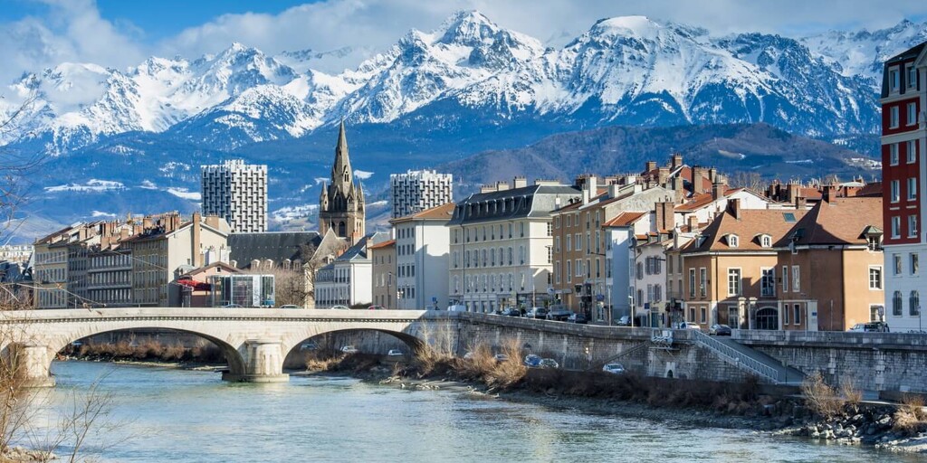
Grenoble, the former capital of the Dauphiné, was transferred to the French monarchy by Humbert Il in 1349, together with all the Dauphin possessions, during the third dynasty of the Dauphins. Humbert Il had no descendants. Grenoble is located at the confluence of the Drac and the lsère. The lsère separates two attractive mountain ranges at the city level, the Vercors (regional nature park) and the Chartreuse. A cable car takes you to the high-altitude Bastille of Grenoble. This 16th-century fortress was adapted to changing war techniques in the 19th century. The view provides captivating panoramas over the two massifs. Grenoble has one of France's most important regional museums, the Musée Dauphinois, in the lower city centre. The Stendhal Museum is also recommended. The mountains are omnipresent here, you can look out on them from every window and balcony. The Massif de la Chartreuse to the north, the Vercors to the west and the Massif de Belledonne to the south: wherever you look, you see mountains. There are also many forts to be seen in the hills surrounding the city. The two most famous are the Fort de la Bastille, which overlooks the Isère and the colourful facades of the Saint-Laurent district, and the Fort Saint-Eynard, from where you have a panoramic view of Grenoble and the surrounding area.
Grenoble is situated in a special place at the foot of the Alps and is a real historical city with much to discover and see. The historical centre is provided with beautiful Gothic facades, small alleys and a lot of restaurants.
The end point of this route is Vizille. In addition to the Route des Dauphins, the old town of Vizille is also located on the Route Napoléon. Vizille is also called the cradle of the French Revolution. The uprising was prepared very early on in the city castle of Vizille. The main attraction is therefore this castle with a 100 ha park. It is considered the most beautiful Renaissance complex in the entire Dauphiné and has its own 'arc de triomphe' in the form of a monumental portal. Between Tuscan columns you will find a bronze horseman in this portal. Vizille's castle served as a residence for the presidents of the French Republic. It now houses the Museum of the French Revolution and offers an in-depth look at turbulent political times that caused changes not only within the French borders but also internationally. In the orangery you will find a model of the Bastille and a bust of Maximilien de Robespierre.
 Links
Links  Usage
Usage Want to download this route?
You can download the route for free without MyRoute-app account. To do so, open the route and click 'save as'. Want to edit this route?
No problem, start by opening the route. Follow the tutorial and create your personal MyRoute-app account. After registration, your trial starts automatically.  Disclaimer
Use of this GPS route is at your own expense and risk. The route has been carefully composed and checked by a MyRoute-app accredited RouteXpert for use on TomTom, Garmin and MyRoute-app Navigation.
Changes may nevertheless have occurred due to changed circumstances, road diversions or seasonal closures. We therefore recommend checking each route before use.
Preferably use the route track in your navigation system. More information about the use of MyRoute-app can be found on the website under 'Community' or 'Academy'.

Auvergne Rhone Alpes
About this region
Auvergne-Rhône-Alpes (ARA; French: [ovɛʁɲ ʁon‿alp] (listen); Arpitan: Ôvèrgne-Rôno-Ârpes; Occitan: Auvèrnhe Ròse Aups; Italian: Alvernia-Rodano-Alpi) is a region in southeast-central France created by the 2014 territorial reform of French regions; it resulted from the merger of Auvergne and Rhône-Alpes. The new region came into effect on 1 January 2016, after the regional elections in December 2015.The region covers an area of 69,711 km2 (26,916 sq mi), making it the third largest in metropolitan France; it had a population of 7,948,287 in 2017, second to Île-de-France. It consists of twelve departments and one territorial collectivity (Lyon Metropolis) with Lyon as the prefecture.
This new region combines diverse geographical, sociological, economic and cultural regions, which was already true of Rhône-Alpes, as well as Auvergne, to a lesser extent. While the old Rhône-Alpes and Auvergne regions each enjoyed a unity defined by axes of communication and the pull of their respective metropoles, the new combination is heterogeneous; it sustained lively opposition from some local officials after its creation.
Read more on Wikipedia
This new region combines diverse geographical, sociological, economic and cultural regions, which was already true of Rhône-Alpes, as well as Auvergne, to a lesser extent. While the old Rhône-Alpes and Auvergne regions each enjoyed a unity defined by axes of communication and the pull of their respective metropoles, the new combination is heterogeneous; it sustained lively opposition from some local officials after its creation.
View region
 Statistics
  125
125Amount of RX reviews (Auvergne Rhone Alpes)
 47945
47945Amount of visitors (Auvergne Rhone Alpes)
 6077
6077Amount of downloads (Auvergne Rhone Alpes)
 Route Collections in this region
 The 24 Most Beautiful Alpine Routes
The Alps, The Alps are a mountain range in Europe, stretching from the French Mediterranean coast in the southwest to the Pannonian Plain in the east. The area of the mountain range is more than 200,000 km².
In other words Passes and Mountain Roads!
Driving through the mountains is great! Especially over the mountain passes with hairpin bends and narrow winding roads. Every bend a different view where you can enjoy. There are many beautiful mountain passes in the Alps.
A selection that has also been incorporated into these routes:
The Stlevio Pass:
The Stelvio Pass, also known as Passo dello Stelvio, is mainly known for the stage in the Giro d'Italia. Due to the length and the difference in height, this pass is seen as one of the toughest tests in cycling. The Stelvio Pass reaches a maximum height of 2758 meters and is therefore one of the highest in the Alps. The pass connects the towns of Bormio and Prato Allo Stelvio. In winter the pass is closed due to heavy snowfall.
The Reschenpass:
The Reschenpass, also known as Passo di Resia, connects the Austrian state of Tyrol with the Italian province of South Tyrol. The pass reaches a maximum height of 1,504 meters and has been one of the most important north-south connections in the Alps in recent centuries. The pass was used long before Roman times. Along the way you will pass several highlights and historical relics. One of the highlights is the Reschensee. This lake was created after the construction of the dam and has completely submerged the village of Graun. The only thing that reminds of that is the clock tower in the middle of the lake.
Col du Galibier:
The French mountain pass Col du Galibier connects the towns of Saint-Michel-de-Maurienne and Briançon via the Col du Lautaret in the south and the Col du Télégraphe in the north. The mountain pass is part of the Tour de France and very much feared, due to the fact that it can only be reached via the other two mountain passes. The pass reaches a maximum height of 2646 meters. From there you can take a walk to the viewpoint at 2704 meters. You can admire the peaks of the Grand Galibier, Mont Blanc and La Meije here.
The Grossglockner High Alpine Road:
With a height of 3798 meters the Grossglockner is the highest mountain in Austria. To fully enjoy this impressive mountain, you can drive over the Grossglockner High Alpine Road and the accompanying pass. The route starts from Bruck am Grossglockner and ends in Heiligenblut. Of course you can drive in two directions. The pass reaches a maximum height of 2504 meters and is closed in winter due to heavy snowfall. Along the way you pass several stops with fun activities, information points, mountain huts and viewpoints. A visit to the Kaiser-Franz-Josefs-Höhe and Pasterzen Glacier is highly recommended.
The Col d'Izoard:
Just like the Col du Galibier, the Col d'Izoard is also part of a stage of the Tour de France. The mountain pass connects Briançon with the valley of the river Guil. The pass is partly located in the Regional Natural Park du Queyras and reaches a maximum height of 2360 meters. What is special about the Col d'Izoard is the barren and rocky landscape. Sometimes it feels like driving a car over the moon! Along the way you can stop at several points to enjoy the beautiful view.
The Bernina Pass:
The Bernina Express is one of the most famous rail trains in Switzerland and the Alps. The route is beautiful and partly included on the UNESCO World Heritage List. Parallel to the railway lies the Bernina pass, which connects the Veltlin valley with the Egandin valley. This beautiful Alpine road has a total length of 56 kilometers and reaches a maximum height of 2328 meters. Along the way you can enjoy views of the Morteratsch Glacier.
The Sella Pass:
The Sella Pass, also known as Passo di Sella, takes you over one of the most impressive mountain ranges in the Dolomites: the Sella massif. The pass connects Valle di Fassa with Val Gardena and reaches a maximum height of 2236 meters. At this height is also the border of the Italian provinces of Trentino and Bolzano. Along the way you can enjoy the view of this spectacular mountain world. Admire, for example, the three peaks of the Sasso Lungo massif, the Sella massif or the peaks of the Marmolada. You can also drive the Sella pass in combination with the Gardena pass, Pordoi pass and Campolongo pass.
The Grimsel Pass:
The Grimsel Pass connects Goms in Wallis with the Halis Valley in the Bernese Oberland. The pass reaches a maximum elevation of 2165 meters and is closed in winter due to snowfall. Over the centuries, the mountain pass has played an important role in trade between Switzerland and Italy. Now it is mainly the reservoirs that have an important function. These are used to generate electricity. The landscape you drive through is rugged, rocky and impressive. On top of the pass is a hotel and a restaurant with a special marmot park. The Dodensee (Totensee) is also located here. This lake owes its name to the many soldiers who died in the time of Napoleon.
The Gotthard Pass:
The Gotthard Pass, also known as Passo del San Gottardo and Saint Gotthard, connects the Swiss towns of Airolo and Andermatt. The mountain pass and associated tunnel are especially known among holidaymakers driving from Switzerland to Italy. But where the majority opt for the tunnel, it is precisely the pass that really completes the holiday. The Gotthard Pass has a length of about 26 kilometers and reaches a maximum height of 2106 meters. The route is beautiful and takes you along old villages and beautiful views.
The Silvretta High Alpine Road and Silvretta Pass:
The Paznaun Valley in Tyrol and the Montafon in Vorarlberg are connected by the Silvretta High Alpine Road. The route has a length of 22.3 kilometers and leads from Galtür to Partenen in 34 hairpin bends, via the 2032 meter high Bielerhöhe. The Silvrettasee is also located at this point, where you can enjoy a lovely walk. The pass is closed in winter due to snowfall.
The Simplon Pass:
Just like the Gotthard Pass, many holidaymakers also travel over the Simplon Pass every year. This mountain pass connects the Rhone Valley in the canton of Valais with the Valle d'Ossola in Piemonte. The pass is open all year round and reaches a maximum height of 2005 meters. Along the way you pass a number of buildings, including the well-known Simplon Hospiz from 1825. The hospiz is managed by the monks of St. Bernard. From the highest point on the pass, all kinds of hiking routes are possible and you will also come across a hotel where you can spend the night.
The Gerlos Pass:
The Gerlos Pass connects the Salzach Valley in the Salzburgerland with the Zillertal Valley in Tyrol. The pass is part of the Gerlos Alpenstraße and runs right through the Hohe Tauern National Park. Along the way you can enjoy beautiful views of the surroundings. The pass has a length of 12 kilometers and reaches a maximum height of 1531 meters. A ride over the Gerlos Pass can be ideally combined with a visit to the Krimmler Wasserfälle.
The Great St. Bernard Pass:
The Great St. Bernard Pass, better known as Col du Grand Saint Bernard, connects the Italian province of Valle d'Aosta with the Swiss canton of Valais. The pass is one of the highest in Switzerland and reaches a maximum height of 2469 meters. Like a number of other mountain passes in this list, the Great St. Bernard Pass has also been used as a connecting road for centuries. The pass is named after the St. Bernard dogs that used to help stranded travelers along with the monks. The pass is closed in winter.
The Timmelsjoch High Alpine Road:
The Timmelsjoch High Alpine Road connects the towns of Sölden in the Ötztal and Meran in South Tyrol. Tolls must be paid on the Hochgurgl - Moos route. Via a mountain road with about 60 hairpin bends you drive through a beautiful mountain world. With the Timmelsjoch Experience you can learn more about the history, the road and the environment via various stations. You can also visit the Top Mountain Crosspoint museum.
Col de l'Iseran:
With a maximum pass height of 2770 meters, the Col l'Iséran is one of the highest mountain passes in the Alps. The pass connects Bourg-Saint-Maurice with Bonneval-sur-Arc. Via a road full of hairpin bends you pass, among other things, Val-d'Isère and a side valley of the Maurienne that lies entirely in the National Park de la Vanoise. You can spot animals such as marmots and chamois and there is also a restaurant with a chapel on top of the pass.
The Gavia Pass:
The Gavia Pass (Italian Passo di Gavia) is a mountain pass in the Italian Alps, in the Lombardy region.
It is one of the highest pass roads in Europe. The road leads through the unspoilt Stelvio National Park. The road was built in the First World War to supply Italian soldiers who fought in the Italian-Austrian border area. The pass height is one of the most beautiful in the Alps. Here is the large Lago Bianco with, to the north, the mountain San Matteo (3684 meters). Lago Nero is slightly lower on the south side of the pass. Here the mountain group of the Adamello determines the view. There are many well-marked walks in the area. During the winter the pass is closed due to the heavy snowfall. The pass is often closed until May and June due to the large amount of snow.
Promoter has made a selection of the 24 Most Beautiful Alpine routes that they have set out in recent years.
The routes go through:
France
Austria
Switzerland
Italy
The most beautiful roads, the most beautiful views, the most beautiful viewpoints. The highest mountains, the fastest descents, hairpin bend after hairpin bend, you name it you can't get enough of it.
If you go on holiday in this region, take advantage of it, ALL routes in this collection have been checked and made equal for TomTom, Garmin and MyRoute-app Navigation by a MyRoute-app RouteXpert.
Have fun with this collection and while driving one of these routes. Enjoy all the beauty that the Alps and the Dolomites have to offer. Click on “View route” to read the review of the chosen route.
I would like to hear your findings about the route(s).
View Route Collection
25 Magnificent trails in France
This MRA route collection contains 25 beautiful motorcycle routes in different parts of France, such as the Ardennes, the Alsace, Vercors, the Drôme, the Ardèche, Cote d'Azure, Gorges du Verdon, the Ariège, the Dordogne and Brittany.
The routes have been carefully created by Bert Loorbach, who is an enthusiastic motorcyclist himself. He lived in France for a year and a half, during which time he devoted himself to mapping the unknown and beautiful back roads of France especially for motorcyclists.
The routes are bundled in the Motortourgids France part 1 of Kosmos publishing house and now also available in MyRouteApp.
I have taken over the routes in MRA and sometimes adjusted them slightly to make them even more interesting for the motorcyclist.
View Route Collection