Rhone valley from Barjac

This route was brought to you by:
RouteXpert Jan Koelstra - Senior Rx
Last edit: 22-11-2025
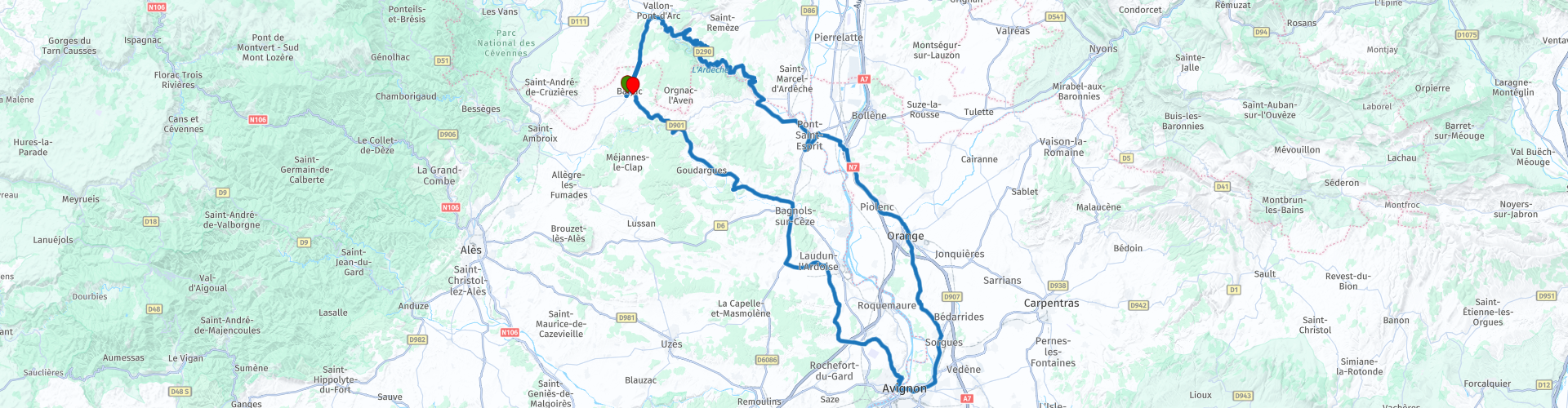
 Route Summary
 The Rhône region is usually divided into the northern and southern parts. Wines from the northern part, where Syrah dominates, therefore differ significantly from those from the southern part, where Grenache Noir is the dominant grape. The southern Rhône region accounts for 80% of the total wine production of the entire Rhône Valley, but is also much more extensive than the northern part.
Because the southern part is so extensive, several routes have been established there. This circular route explores the southwestern part of the Côtes du Rhône. It begins and ends in Barjac.
Numerous wine-growing towns and villages host wine tastings. There's also plenty to see, and the route's roads weave through the vineyards, offering glimpses of the daily work in the wine industry. Enjoy the famous vineyards, picturesque villages, and stunning natural scenery, such as the Gorges de l'Ardèche. The diverse nature of the tour makes it a fantastic driving experience, worthy of a five-star rating!
 Share this route


Animation

Verdict


Duration
9h 44m

Mode of travel
Car or motorcycle

Distance
301.45 km

Countries

 RouteXpert Review
 You've undoubtedly seen Côtes du Rhône and Côtes du Rhône Villages on supermarket shelves. They are the two major appellations of the southern Rhône Valley, between Montélimar and Avignon. Côtes du Rhône Villages is the better quality of the two: it features wines from communes with a better terroir, meaning a better mix of natural factors (microclimate, topography, soil composition, etc.) that results in better grapes and therefore better wine.
In the past, Châteauneuf-du-Pape, Gigondas, Vacqueyras, and Lirac distinguished themselves from other communes. Due to their superior terroir, they became separate appellations and were only allowed to use their own commune name on their labels. Gradually, new communes were also able to break away from the pack: they obtained the right to add their commune name to the generic appellation of Côtes du Rhône Villages.
Because the southern part is so extensive, several routes have been set out.
This circular route explores the southwestern part of the Côtes du Rhône. It begins and ends in Barjac in the Gard department.
Barjac
Barjac is a charming village located in the former Languedoc-Roussillon region. Due to its location, the village has always enjoyed a vibrant trade. Situated between the Gorges de la Cèze and the Gorges de l'Ardèche, Barjac certainly boasts its characteristically French streets and charming squares. Known for its renowned antique and flea market, Barjac is also an ideal base for exploring breathtaking landscapes, from millennial caves to winding rivers like the Gorges de l'Ardèche.
The Gorges de l'Ardèche run from the town of Vallon-Pont-d'Arc to Saint-Martin-d'Ardèche. The D290, a winding road with several viewpoints, runs alongside it. The Pont d'Arc near Vallon-Pont-d'Arc, a naturally created arch bridge over the river, is particularly well-known. The gorges of the Ardèche were formed by the erosion of the limestone mountains. Millions of years ago, the area was flooded several times, causing limestone to deposit on the rocky ground. Earth movements, glaciers, and rainwater have further eroded the gorges, creating beautiful scenery. Several caves have also been formed.
Pont-Saint-Esprit (coffee stop)
The Saint-Esprit Bridge is undoubtedly the town's landmark. Built between 1265 and 1344, this medieval bridge impresses with its robustness and beauty. Composed of numerous arches, it majestically spans the Rhône, offering breathtaking views of the river and the surrounding countryside. The bridge also marks the confluence of the Ardèche and Rhône rivers. The town has retained its original character over the centuries. There's plenty to see in this town, including the 12th-century Priory of Saint-Pierre and the Maison des Chevaliers, which houses the Musée d'Art Sacré du Gard. Several 15th-century mansions can also be found in the town's historic center.
Mornas
After coffee, cross the Rhône and you'll soon see Mornas and its medieval fortress perched on the cliff. The military system surrounding this citadel dates back to the 10th century and was fortified in the 12th century when it came into the hands of the Counts of Toulouse, who placed it under papal authority from the 13th century onward. After the Wars of Religion, the building was abandoned, and in 1977 the "Les amis de Mornas" association began its restoration. The entire complex is open to the public; guides in period costume will transport you back to the era of chivalry with re-enactments of scenes from medieval life in the castle. A fantastic view of the Rhône Valley awaits you at the defensive wall.
Orange
Orange has become world-famous for its distinctive Roman architecture and the magnificent statue of Emperor Augustus. As a garrison town, the city developed according to Roman knowledge and culture. This resulted in several now ancient Roman monuments in Orange, such as the Triumphal Arch and the Theater, including its unique, towering rear wall. Both structures are UNESCO World Heritage sites. The Romans also built a temple, a bathhouse, and an aqueduct.
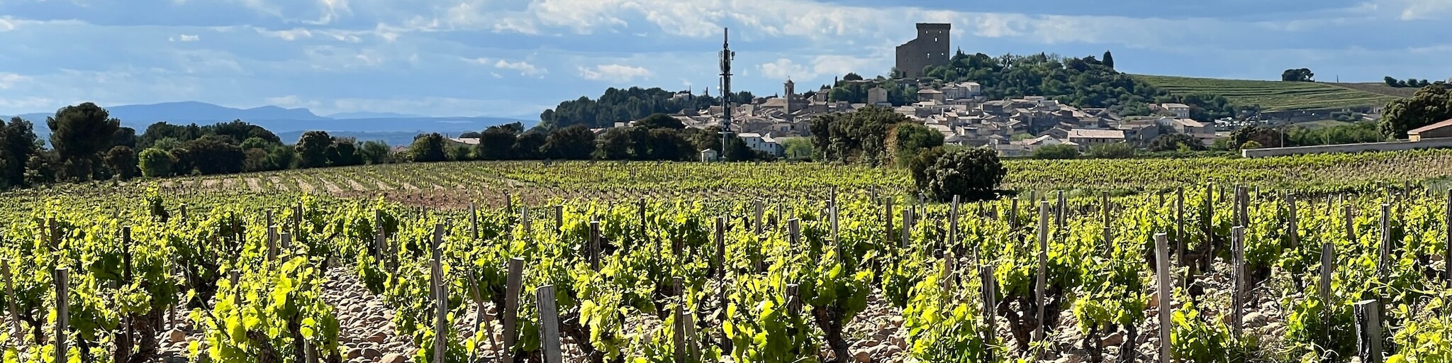
Châteauneuf-du-Pape
A little further along lies Châteauneuf-du-Pape, in the eponymous wine region of the Rhône Valley, between Avignon and Orange. This picturesque village, with a population of around 2,000, is a maze of medieval streets and steep alleyways with numerous steps. You'll find charming squares, cozy terraces under plane trees, inviting restaurants, and, of course, several wine tasting spots. While strolling through Châteauneuf-du-Pape, be sure to stop at L'église Notre-Dame de l'Assomption, an 11th-century church. Directly opposite the church is Rue de l'Eglise. This narrow street is immediately noticeable because of its gate, topped by a house. The path slopes downward, giving the street its nickname, Rompe Cul; apparently, many falls have occurred there over the centuries. On Place du Portail you will find several pleasant terraces and here you can also see the Grande Fontaine de Châteauneuf-du-Pape, the main fountain in the village, which is said to have been present at the beginning of the 17th century.
Avignon
The city is simply called the "City of the Popes" because it served as the seat of the papacy several times between 1309 and 1411. The presence of the seat of Western Christianity attracted a large number of wealthy Italian merchants. Many traces of this period remain, such as the Palais des Papes. And don't forget the famous Saint-Bénezet Bridge, immortalized in a nursery rhyme. Avignon is also home to one of France's largest theater festivals. Avignon is also notable for still retaining its ramparts. Dating back to the 1480s, they were built to protect the papal city from the "roaders" and "mercenaries" who plundered the Rhône Valley during each truce of the Hundred Years' War.
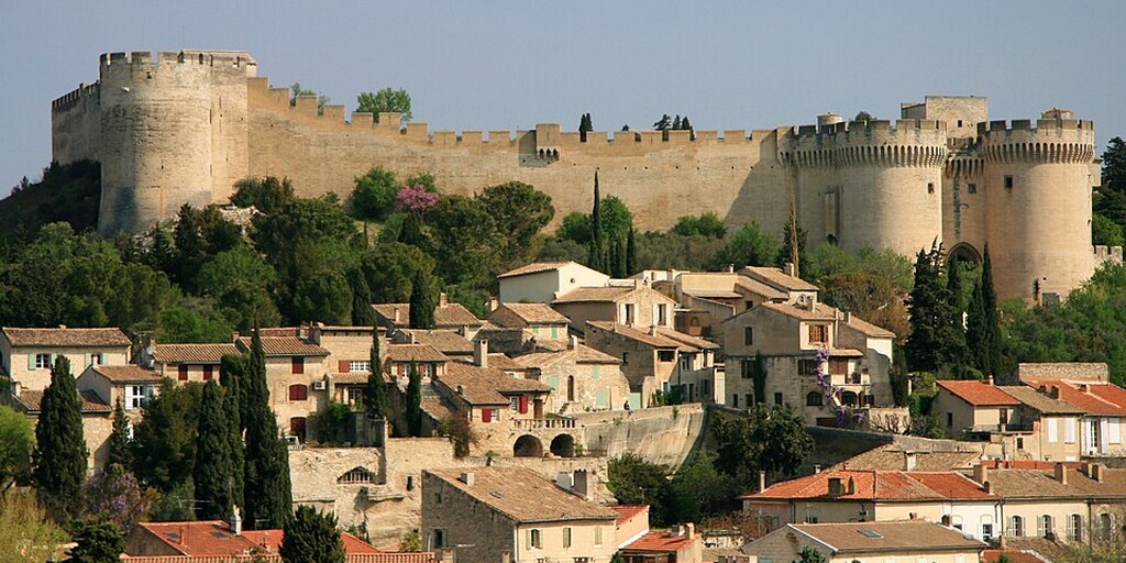
Villeneuve-lès-Avignon (lunch stop)
This charming medieval town, with its imposing Saint-André fortress, lies on the banks of the Rhône River, directly opposite Avignon. It also offers stunning natural views of Mont Ventoux and the Alpilles mountains. Lovers of old architecture will be in their element here, as several major buildings are well worth a visit. The first is the Benedictine Abbey of Saint-André, a harmonious place that combines gardens, historical heritage, and the history of Provence since the 6th century. The lush terraced gardens flourish around the remains of Romanesque churches and tombs. You'll find centuries-old olive trees, pines, and Mediterranean plants here, as well as stunning views over Avignon! There's also the impressive fortress. The abbey palace, renovated in the 17th century, still boasts elegant vaulted rooms, murals, a portal, and a monumental staircase, and it hosts numerous art and music events.
Laudun
Laudun, located in the southern Rhône Valley, is a village that occupies a remarkable position within the Côtes du Rhône Villages appellation. On the banks of the Rhône, where the Cèze and Tave rivers flow, Laudun clings to the slopes of a hill, offering stunning views over the valley. Famous for its AOC wines, Laudun is not only a typical wine-growing village but also boasts many architectural treasures: the Balouvière aqueduct, the 18-hectare Caesar's Camp (the remains of a Roman village inhabited for over a thousand years), and the Gothic church of Notre-Dame la Neuve, built on the remains of the Romanesque church of Saint-Geniès.
Bagnols-sur-Cèze (drink stop)
The city's main highlight, and also the perfect spot for a drink, is the large central square, originally Place du Marché and now Place Mallet. The town hall, built in 1675, dominates one side of the square. On both sides are arcades and several cafés. The cross in the square dates from the 18th century. A short distance from Place Mallet stands a medieval clock tower. There are plenty of terraces where you can relax and enjoy the view.
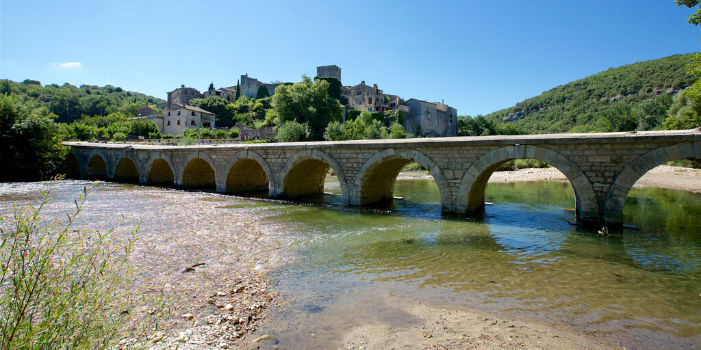
La Roque-sur-Cèze
La Roque-sur-Cèze is a medieval village perched high on a rocky outcrop, offering stunning views of the Sautadet Falls. This magnificent panoramic view gives this historic and well-preserved site its undeniable charm.
Montclus
Montclus is a beautifully preserved village on the Cèze River. Experts consider it one of the most beautiful villages in all of France. This small, restored village offers visitors charming, narrow streets lined with beautiful old buildings. Walking through the village, you'll feel transported back to the Middle Ages. The village's location is also stunning. Montclus lies at the foot of a hill, on the edge of lavender fields.
You've almost completed your tour of this Côtes du Rhône region. The last stretch to Barjac runs through the vineyards. As you enter the emblematic medieval village of Barjac, with the majestic Château de Barjac at its heart, you can visit it. This monumental fortress, with its imposing towers, sturdy ramparts, and elegant vaulted rooms, bears witness to a turbulent history. Visitors can explore the many rooms, some of which house exhibitions on local history and regional crafts. But be sure to relax on a terrace and process all your impressions with a glass of local Côtes du Rhône!
 Links
Links  Usage
Usage Want to download this route?
You can download the route for free without MyRoute-app account. To do so, open the route and click 'save as'. Want to edit this route?
No problem, start by opening the route. Follow the tutorial and create your personal MyRoute-app account. After registration, your trial starts automatically.  Disclaimer
Use of this GPS route is at your own expense and risk. The route has been carefully composed and checked by a MyRoute-app accredited RouteXpert for use on TomTom, Garmin and MyRoute-app Navigation.
Changes may nevertheless have occurred due to changed circumstances, road diversions or seasonal closures. We therefore recommend checking each route before use.
Preferably use the route track in your navigation system. More information about the use of MyRoute-app can be found on the website under 'Community' or 'Academy'.

Auvergne Rhone Alpes
About this region
Auvergne-Rhône-Alpes (ARA; French: [ovɛʁɲ ʁon‿alp] (listen); Arpitan: Ôvèrgne-Rôno-Ârpes; Occitan: Auvèrnhe Ròse Aups; Italian: Alvernia-Rodano-Alpi) is a region in southeast-central France created by the 2014 territorial reform of French regions; it resulted from the merger of Auvergne and Rhône-Alpes. The new region came into effect on 1 January 2016, after the regional elections in December 2015.The region covers an area of 69,711 km2 (26,916 sq mi), making it the third largest in metropolitan France; it had a population of 7,948,287 in 2017, second to Île-de-France. It consists of twelve departments and one territorial collectivity (Lyon Metropolis) with Lyon as the prefecture.
This new region combines diverse geographical, sociological, economic and cultural regions, which was already true of Rhône-Alpes, as well as Auvergne, to a lesser extent. While the old Rhône-Alpes and Auvergne regions each enjoyed a unity defined by axes of communication and the pull of their respective metropoles, the new combination is heterogeneous; it sustained lively opposition from some local officials after its creation.
Read more on Wikipedia
This new region combines diverse geographical, sociological, economic and cultural regions, which was already true of Rhône-Alpes, as well as Auvergne, to a lesser extent. While the old Rhône-Alpes and Auvergne regions each enjoyed a unity defined by axes of communication and the pull of their respective metropoles, the new combination is heterogeneous; it sustained lively opposition from some local officials after its creation.
View region
 Statistics
  129
129Amount of RX reviews (Auvergne Rhone Alpes)
 54206
54206Amount of visitors (Auvergne Rhone Alpes)
 6736
6736Amount of downloads (Auvergne Rhone Alpes)
 Route Collections in this region
 The 24 Most Beautiful Alpine Routes
The Alps, The Alps are a mountain range in Europe, stretching from the French Mediterranean coast in the southwest to the Pannonian Plain in the east. The area of the mountain range is more than 200,000 km².
In other words Passes and Mountain Roads!
Driving through the mountains is great! Especially over the mountain passes with hairpin bends and narrow winding roads. Every bend a different view where you can enjoy. There are many beautiful mountain passes in the Alps.
A selection that has also been incorporated into these routes:
The Stlevio Pass:
The Stelvio Pass, also known as Passo dello Stelvio, is mainly known for the stage in the Giro d'Italia. Due to the length and the difference in height, this pass is seen as one of the toughest tests in cycling. The Stelvio Pass reaches a maximum height of 2758 meters and is therefore one of the highest in the Alps. The pass connects the towns of Bormio and Prato Allo Stelvio. In winter the pass is closed due to heavy snowfall.
The Reschenpass:
The Reschenpass, also known as Passo di Resia, connects the Austrian state of Tyrol with the Italian province of South Tyrol. The pass reaches a maximum height of 1,504 meters and has been one of the most important north-south connections in the Alps in recent centuries. The pass was used long before Roman times. Along the way you will pass several highlights and historical relics. One of the highlights is the Reschensee. This lake was created after the construction of the dam and has completely submerged the village of Graun. The only thing that reminds of that is the clock tower in the middle of the lake.
Col du Galibier:
The French mountain pass Col du Galibier connects the towns of Saint-Michel-de-Maurienne and Briançon via the Col du Lautaret in the south and the Col du Télégraphe in the north. The mountain pass is part of the Tour de France and very much feared, due to the fact that it can only be reached via the other two mountain passes. The pass reaches a maximum height of 2646 meters. From there you can take a walk to the viewpoint at 2704 meters. You can admire the peaks of the Grand Galibier, Mont Blanc and La Meije here.
The Grossglockner High Alpine Road:
With a height of 3798 meters the Grossglockner is the highest mountain in Austria. To fully enjoy this impressive mountain, you can drive over the Grossglockner High Alpine Road and the accompanying pass. The route starts from Bruck am Grossglockner and ends in Heiligenblut. Of course you can drive in two directions. The pass reaches a maximum height of 2504 meters and is closed in winter due to heavy snowfall. Along the way you pass several stops with fun activities, information points, mountain huts and viewpoints. A visit to the Kaiser-Franz-Josefs-Höhe and Pasterzen Glacier is highly recommended.
The Col d'Izoard:
Just like the Col du Galibier, the Col d'Izoard is also part of a stage of the Tour de France. The mountain pass connects Briançon with the valley of the river Guil. The pass is partly located in the Regional Natural Park du Queyras and reaches a maximum height of 2360 meters. What is special about the Col d'Izoard is the barren and rocky landscape. Sometimes it feels like driving a car over the moon! Along the way you can stop at several points to enjoy the beautiful view.
The Bernina Pass:
The Bernina Express is one of the most famous rail trains in Switzerland and the Alps. The route is beautiful and partly included on the UNESCO World Heritage List. Parallel to the railway lies the Bernina pass, which connects the Veltlin valley with the Egandin valley. This beautiful Alpine road has a total length of 56 kilometers and reaches a maximum height of 2328 meters. Along the way you can enjoy views of the Morteratsch Glacier.
The Sella Pass:
The Sella Pass, also known as Passo di Sella, takes you over one of the most impressive mountain ranges in the Dolomites: the Sella massif. The pass connects Valle di Fassa with Val Gardena and reaches a maximum height of 2236 meters. At this height is also the border of the Italian provinces of Trentino and Bolzano. Along the way you can enjoy the view of this spectacular mountain world. Admire, for example, the three peaks of the Sasso Lungo massif, the Sella massif or the peaks of the Marmolada. You can also drive the Sella pass in combination with the Gardena pass, Pordoi pass and Campolongo pass.
The Grimsel Pass:
The Grimsel Pass connects Goms in Wallis with the Halis Valley in the Bernese Oberland. The pass reaches a maximum elevation of 2165 meters and is closed in winter due to snowfall. Over the centuries, the mountain pass has played an important role in trade between Switzerland and Italy. Now it is mainly the reservoirs that have an important function. These are used to generate electricity. The landscape you drive through is rugged, rocky and impressive. On top of the pass is a hotel and a restaurant with a special marmot park. The Dodensee (Totensee) is also located here. This lake owes its name to the many soldiers who died in the time of Napoleon.
The Gotthard Pass:
The Gotthard Pass, also known as Passo del San Gottardo and Saint Gotthard, connects the Swiss towns of Airolo and Andermatt. The mountain pass and associated tunnel are especially known among holidaymakers driving from Switzerland to Italy. But where the majority opt for the tunnel, it is precisely the pass that really completes the holiday. The Gotthard Pass has a length of about 26 kilometers and reaches a maximum height of 2106 meters. The route is beautiful and takes you along old villages and beautiful views.
The Silvretta High Alpine Road and Silvretta Pass:
The Paznaun Valley in Tyrol and the Montafon in Vorarlberg are connected by the Silvretta High Alpine Road. The route has a length of 22.3 kilometers and leads from Galtür to Partenen in 34 hairpin bends, via the 2032 meter high Bielerhöhe. The Silvrettasee is also located at this point, where you can enjoy a lovely walk. The pass is closed in winter due to snowfall.
The Simplon Pass:
Just like the Gotthard Pass, many holidaymakers also travel over the Simplon Pass every year. This mountain pass connects the Rhone Valley in the canton of Valais with the Valle d'Ossola in Piemonte. The pass is open all year round and reaches a maximum height of 2005 meters. Along the way you pass a number of buildings, including the well-known Simplon Hospiz from 1825. The hospiz is managed by the monks of St. Bernard. From the highest point on the pass, all kinds of hiking routes are possible and you will also come across a hotel where you can spend the night.
The Gerlos Pass:
The Gerlos Pass connects the Salzach Valley in the Salzburgerland with the Zillertal Valley in Tyrol. The pass is part of the Gerlos Alpenstraße and runs right through the Hohe Tauern National Park. Along the way you can enjoy beautiful views of the surroundings. The pass has a length of 12 kilometers and reaches a maximum height of 1531 meters. A ride over the Gerlos Pass can be ideally combined with a visit to the Krimmler Wasserfälle.
The Great St. Bernard Pass:
The Great St. Bernard Pass, better known as Col du Grand Saint Bernard, connects the Italian province of Valle d'Aosta with the Swiss canton of Valais. The pass is one of the highest in Switzerland and reaches a maximum height of 2469 meters. Like a number of other mountain passes in this list, the Great St. Bernard Pass has also been used as a connecting road for centuries. The pass is named after the St. Bernard dogs that used to help stranded travelers along with the monks. The pass is closed in winter.
The Timmelsjoch High Alpine Road:
The Timmelsjoch High Alpine Road connects the towns of Sölden in the Ötztal and Meran in South Tyrol. Tolls must be paid on the Hochgurgl - Moos route. Via a mountain road with about 60 hairpin bends you drive through a beautiful mountain world. With the Timmelsjoch Experience you can learn more about the history, the road and the environment via various stations. You can also visit the Top Mountain Crosspoint museum.
Col de l'Iseran:
With a maximum pass height of 2770 meters, the Col l'Iséran is one of the highest mountain passes in the Alps. The pass connects Bourg-Saint-Maurice with Bonneval-sur-Arc. Via a road full of hairpin bends you pass, among other things, Val-d'Isère and a side valley of the Maurienne that lies entirely in the National Park de la Vanoise. You can spot animals such as marmots and chamois and there is also a restaurant with a chapel on top of the pass.
The Gavia Pass:
The Gavia Pass (Italian Passo di Gavia) is a mountain pass in the Italian Alps, in the Lombardy region.
It is one of the highest pass roads in Europe. The road leads through the unspoilt Stelvio National Park. The road was built in the First World War to supply Italian soldiers who fought in the Italian-Austrian border area. The pass height is one of the most beautiful in the Alps. Here is the large Lago Bianco with, to the north, the mountain San Matteo (3684 meters). Lago Nero is slightly lower on the south side of the pass. Here the mountain group of the Adamello determines the view. There are many well-marked walks in the area. During the winter the pass is closed due to the heavy snowfall. The pass is often closed until May and June due to the large amount of snow.
Promoter has made a selection of the 24 Most Beautiful Alpine routes that they have set out in recent years.
The routes go through:
France
Austria
Switzerland
Italy
The most beautiful roads, the most beautiful views, the most beautiful viewpoints. The highest mountains, the fastest descents, hairpin bend after hairpin bend, you name it you can't get enough of it.
If you go on holiday in this region, take advantage of it, ALL routes in this collection have been checked and made equal for TomTom, Garmin and MyRoute-app Navigation by a MyRoute-app RouteXpert.
Have fun with this collection and while driving one of these routes. Enjoy all the beauty that the Alps and the Dolomites have to offer. Click on “View route” to read the review of the chosen route.
I would like to hear your findings about the route(s).
View Route Collection
25 Magnificent trails in France
This MRA route collection contains 25 beautiful motorcycle routes in different parts of France, such as the Ardennes, the Alsace, Vercors, the Drôme, the Ardèche, Cote d'Azure, Gorges du Verdon, the Ariège, the Dordogne and Brittany.
The routes have been carefully created by Bert Loorbach, who is an enthusiastic motorcyclist himself. He lived in France for a year and a half, during which time he devoted himself to mapping the unknown and beautiful back roads of France especially for motorcyclists.
The routes are bundled in the Motortourgids France part 1 of Kosmos publishing house and now also available in MyRouteApp.
I have taken over the routes in MRA and sometimes adjusted them slightly to make them even more interesting for the motorcyclist.
View Route Collection