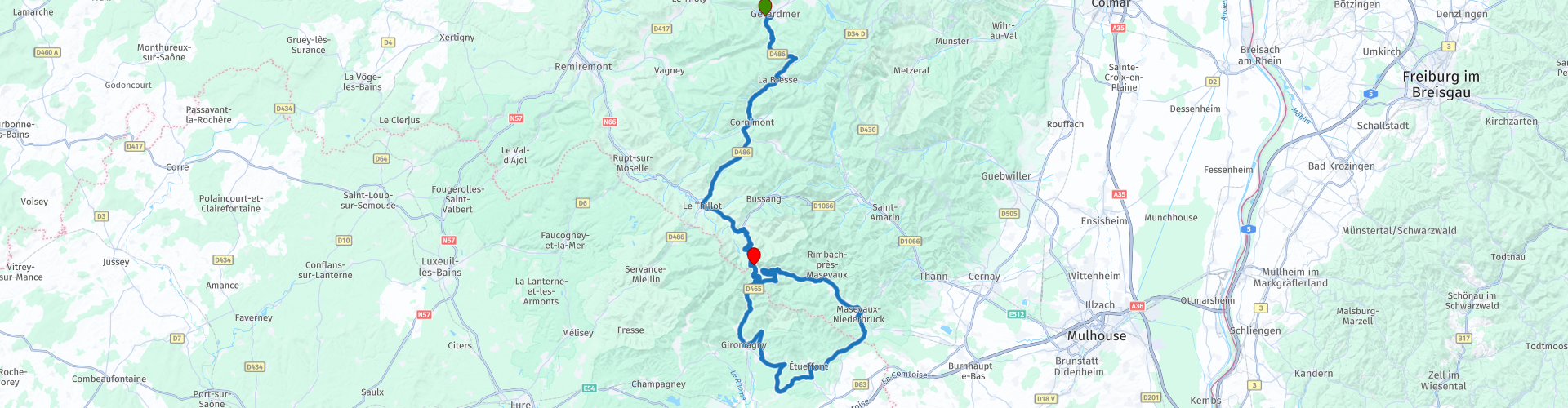
MTG1 04 Gerardmer LaBresse Cornimont LeThillot and roundtrip Ballon dAlsac

This route was brought to you by:
RouteXpert René Plücken (MRA Master)
Last edit: 20-08-2025
 Route Summary
 There aren't many sights to visit along the route, but because of the beautiful scenery and pleasant winding roads, I still rate this route with 5 stars.
Tip: If you have enough time, you can also drive the route in the opposite direction.
 Share this route


Animation

Verdict


Duration
4h 16m

Mode of travel
Car or motorcycle

Distance
114.96 km

Countries

 RouteXpert Review
 Bert Loorbach, the author, is an avid motorcyclist himself and lived in France for a year and a half. During that time, he dedicated himself to mapping France's lesser-known and beautiful back roads specifically for motorcyclists.
This is the fourth route in the book. It starts in Gérardmer and ends in Chernay. There are hotels and campsites nearby, which are listed as points of interest. This route includes several beautiful cols, such as the Col du Haut de la Côte, Col de Grosse Pierre, and Col La Gentiane.
The ride starts in Gérardmer, nestled among mountains covered in dense pine forests on the largest lake in the Vosges, Lac de Gérardmer. It's a great base for several rides, and this is one of three routes that start here.
The first part of the route goes to La Bresse, where we cycle over the Col de Grosse Pierre and through a beautiful valley.
From La Bresse, we follow the D486, which runs along the Moselotte River to Cornimont. From Cornimont, we drive through a beautiful valley to Le Thillot, where you can stop for a coffee in one of the cafés.
From Le Thillot, we ride 6 km along the N6 to the turnoff that marks the beginning of the circuit that cuts through the Ballons des Vosges Regional Park and takes you past the famous Ballon d'Alsace. This road is considered one of the top 10 most beautiful roads in France by French motorcyclists. So take your time to enjoy this road and the beautiful panoramas. There are plenty of opportunities to stop and admire the surroundings.
The 1,247-meter-high Ballon d'Alsace is a mountain in France in the southern Vosges Mountains. From the summit, Mont Blanc can be seen in clear weather. The road, which connects the Moselle Valley in the north with the Savoureuse Valley in the south and the Doller Valley in the east, passes over a pass at an altitude of 1,171 meters. The Ballon d'Alsace is also very popular with cyclists, so be aware that it can be busy and drive at a reasonable speed.
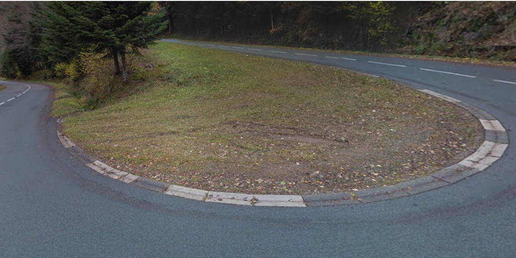
The first section immediately includes a number of nice hairpin bends and along the way you pass the Hotel du Sommet where you may be staying that evening, so it is an option to stop and check in and leave your luggage.
You'll ride clockwise along Rue de Ballon d'Alsace, the first section being a scenic descent through a wooded area. The route offers beautiful panoramic views along the way.
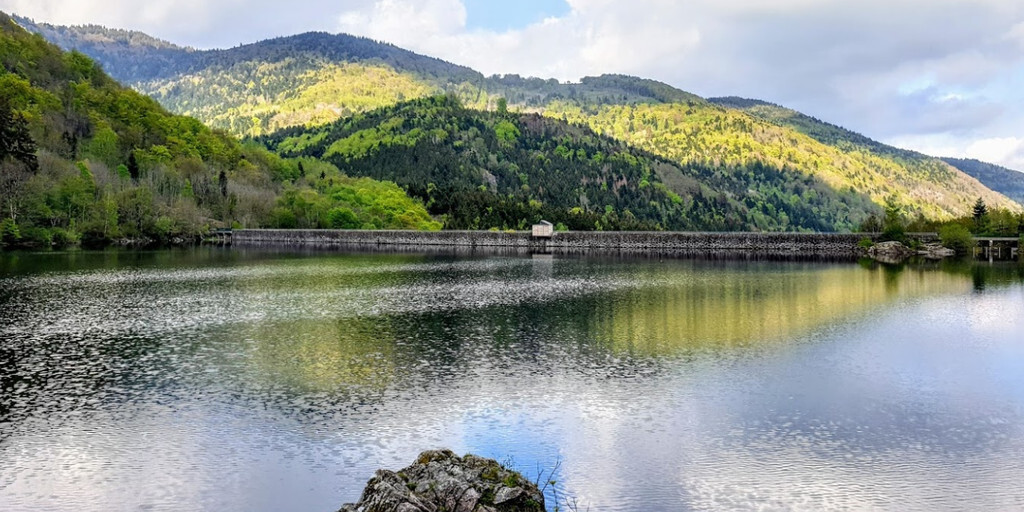
The first place to stop and take photos is Lac d'Alfeld, one of the most beautiful lakes in the Vosges Mountains and truly stunning. Hiking is also possible.
In Masevaux-Niederbruck there is the possibility to have a drink and/or something to eat in one of the small restaurants and cafes.
The route continues via Masevaux, Rougemont le Château, Grosmagny, Petitmagny and Giromagny. This is also a very beautiful road, also known as La Trouée de Belfort, and is a narrow passage between the Vosges and the Jura mountains.
At Rougegoute, you deviate from the original route for a short distance to follow the D24, a beautiful winding road. From Giromagny, you follow the original route again, which climbs to the finish at the Ballon d'Alsace with some very beautiful hairpin bends.
At the top of the mountain, you'll arrive at the Hôtel du Sommet, where you can stay overnight. Alternatively, there's a campsite near the village of Oberbruck.
Take your time on this route; you can occasionally deviate from the road and take a small, off-road path. Be careful, though, as some roads can be very narrow and gravel.
 Links
Links  Usage
Usage Want to download this route?
You can download the route for free without MyRoute-app account. To do so, open the route and click 'save as'. Want to edit this route?
No problem, start by opening the route. Follow the tutorial and create your personal MyRoute-app account. After registration, your trial starts automatically.  Disclaimer
Use of this GPS route is at your own expense and risk. The route has been carefully composed and checked by a MyRoute-app accredited RouteXpert for use on TomTom, Garmin and MyRoute-app Navigation.
Changes may nevertheless have occurred due to changed circumstances, road diversions or seasonal closures. We therefore recommend checking each route before use.
Preferably use the route track in your navigation system. More information about the use of MyRoute-app can be found on the website under 'Community' or 'Academy'.

Grand Est
About this region
Grand Est (French: [ɡʁɑ̃t‿ɛst] (listen); Alsatian: Grossa Oschta; Moselle Franconian/Luxembourgish: Grouss Osten;
Rhine Franconian: Groß Oschte; German: Großer Osten [ˈɡʁoːsɐ ˈʔɔstn̩]; English: "Greater East") is an administrative region in Northeastern France. It superseded three former administrative regions, Alsace, Champagne-Ardenne and Lorraine, on 1 January 2016 under the provisional name of Alsace-Champagne-Ardenne-Lorraine (pronounced [alzas ʃɑ̃paɲ aʁdɛn lɔʁɛn]; ACAL or, less commonly, ALCA), as a result of territorial reform which had been passed by the French Parliament in 2014.The region sits astride three water basins (Seine, Meuse and Rhine), spanning an area of 57,433 km2 (22,175 sq mi), the fifth largest in France; it includes two mountain ranges (Vosges and Ardennes). It shares borders with Belgium, Luxembourg, Germany and Switzerland. As of 2017, it had a population of 5,549,586 inhabitants. The prefecture and largest city, by far, is Strasbourg.
The East of France has a rich and diverse culture, being situated at a crossroads between the Latin and Germanic worlds. This history is reflected in the variety of languages spoken there (Alsatian, Champenois, and Lorraine Franconian). Most of today's Grand Est region was considered "Eastern" as early as the 8th century, when it constituted the southern part of the Francian territory of Austrasia. The city of Reims (in Champagne), where Frankish king Clovis I had been baptized in 496 AD, would later play a prominent ceremonial role in French monarchical history as the traditional site of the coronation of the kings of France. The Champagne fairs played a significant role in the economy of medieval Europe as well. Alsace and Lorraine thrived in the sphere of influence of the Holy Roman Empire for most of the Middle Ages and Renaissance, and subject to competing claims by France and German over the centuries.
The region has distinctive traditions such as the celebration of Saint Nicholas Day, Christmas markets, or traditions involving the Easter hare in Alsace and Lorraine. Alsace-Moselle are furthermore subject to local law for historical reasons. With a long industrial history and strong agriculture and tourism (arts, gastronomy, sightseeing), the East of France is one of the top economic producing regions in the country.
Read more on Wikipedia
Rhine Franconian: Groß Oschte; German: Großer Osten [ˈɡʁoːsɐ ˈʔɔstn̩]; English: "Greater East") is an administrative region in Northeastern France. It superseded three former administrative regions, Alsace, Champagne-Ardenne and Lorraine, on 1 January 2016 under the provisional name of Alsace-Champagne-Ardenne-Lorraine (pronounced [alzas ʃɑ̃paɲ aʁdɛn lɔʁɛn]; ACAL or, less commonly, ALCA), as a result of territorial reform which had been passed by the French Parliament in 2014.The region sits astride three water basins (Seine, Meuse and Rhine), spanning an area of 57,433 km2 (22,175 sq mi), the fifth largest in France; it includes two mountain ranges (Vosges and Ardennes). It shares borders with Belgium, Luxembourg, Germany and Switzerland. As of 2017, it had a population of 5,549,586 inhabitants. The prefecture and largest city, by far, is Strasbourg.
The East of France has a rich and diverse culture, being situated at a crossroads between the Latin and Germanic worlds. This history is reflected in the variety of languages spoken there (Alsatian, Champenois, and Lorraine Franconian). Most of today's Grand Est region was considered "Eastern" as early as the 8th century, when it constituted the southern part of the Francian territory of Austrasia. The city of Reims (in Champagne), where Frankish king Clovis I had been baptized in 496 AD, would later play a prominent ceremonial role in French monarchical history as the traditional site of the coronation of the kings of France. The Champagne fairs played a significant role in the economy of medieval Europe as well. Alsace and Lorraine thrived in the sphere of influence of the Holy Roman Empire for most of the Middle Ages and Renaissance, and subject to competing claims by France and German over the centuries.
The region has distinctive traditions such as the celebration of Saint Nicholas Day, Christmas markets, or traditions involving the Easter hare in Alsace and Lorraine. Alsace-Moselle are furthermore subject to local law for historical reasons. With a long industrial history and strong agriculture and tourism (arts, gastronomy, sightseeing), the East of France is one of the top economic producing regions in the country.
View region
 Statistics
  81
81Amount of RX reviews (Grand Est)
 38061
38061Amount of visitors (Grand Est)
 12938
12938Amount of downloads (Grand Est)
 Route Collections in this region
 25 Magnificent trails in France
This MRA route collection contains 25 beautiful motorcycle routes in different parts of France, such as the Ardennes, the Alsace, Vercors, the Drôme, the Ardèche, Cote d'Azure, Gorges du Verdon, the Ariège, the Dordogne and Brittany.
The routes have been carefully created by Bert Loorbach, who is an enthusiastic motorcyclist himself. He lived in France for a year and a half, during which time he devoted himself to mapping the unknown and beautiful back roads of France especially for motorcyclists.
The routes are bundled in the Motortourgids France part 1 of Kosmos publishing house and now also available in MyRouteApp.
I have taken over the routes in MRA and sometimes adjusted them slightly to make them even more interesting for the motorcyclist.
View Route Collection
11 day trip from the Netherlands
8 countries in 11 days; The Netherlands, Germany, Austria, Italy, Switzerland, France, Luxembourg and Belgium. This route collections consists of 10 routes that I have driven with friends in the summer of 2019.
The start is in Geldermalsen Netherlands, the first 7 days you drive through the Netherlands, Germany, Austria, Italy, Switzerland, France and a piece of Luxembourg with overnight stays in hotels.
The last three days you stay in Barweiler (D) in the Eifel and you drive two beautiful tours through the Eifel, Luxembourg and parts of the Belgian Ardennes.
There is no highway in the routes, only beautiful provincial and country roads, many beautiful passes with beautiful panoramas.
Be sure to check whether the passes are open before you leave.
These are routes for experienced drivers.
View Route Collection