Fortified Cities from Berck

This route was brought to you by:
RouteXpert Jan Koelstra - Senior Rx
Last edit: 28-01-2025
 Route Summary
 In addition to admiring these fortifications, attention is also paid to the coastal region with its capes, cliffs, dunes and beaches. Also, along the route, remains of the Atlantic Wall are visible.
The route has been awarded five stars because of the variety between the vastness of the landscape, beaches and cliffs on the one hand and the ingenious constructions of the fortified towns and forts on the other.
 Share this route


Animation

Verdict


Duration
9h 11m

Mode of travel
Car or motorcycle

Distance
194.81 km

Countries

 RouteXpert Review
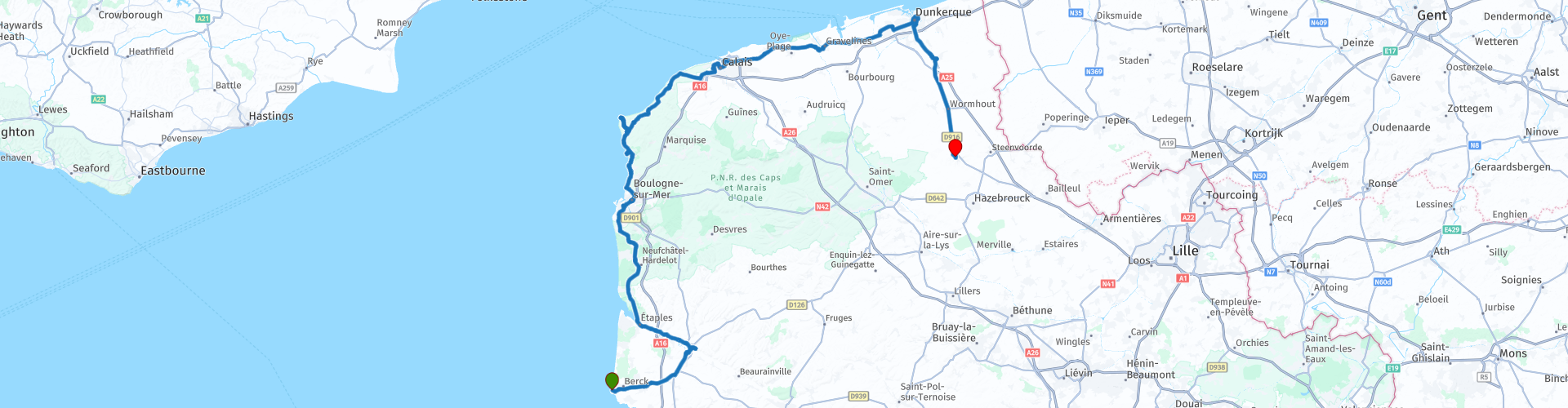
 This route runs from the Berck lighthouse, located at the mouth of the Authie to Cassel and mainly follows the coast. Berck-sur-Mer has one of the most beautiful beaches on the Opal Coast. Here, along the dunes and the sea, you breathe in a good dose of iodine-rich air for extra energy to the first fortified town on your route: Montreuil-sur-Mer.
The high ramparts tower above a rolling green landscape of hills and forests. Contrary to what its name suggests, Montreuil-sur-Mer is not on the sea. In the Middle Ages, the town still had a port, but today Montreuil is 16 km from the Opal Coast.
Around the old town you will find one of the oldest stone city walls that France still has. The western front of the fortifications contains five round towers from the 13th century and the bastion Bouillon. You can do your own 'tour des remparts', a 3 km long walk over and along the city defenses. To the north of the city lies the citadel with its star-shaped pattern. Not only life and limb were kept within the city walls, but also the treasure of St.-Saulve. This curious treasure with a 7th century cross, enamel work and silver relics from the 14th century can be found in the abbey church of St.-Saulve.
Just outside Montreuil-sur-Mer you can visit the large Carthusian monastery of Neuville. During the free tour (you will receive a map) you can visit the chapter house, the library, the monks' cells, the dining room and also the (vegetable) gardens.
Just outside Neuville you will find a Leclerc petrol station for some much-needed fuel.
A highlight on the route is Boulogne-sur-Mer. Both Julius Caesar and Napoleon chose Boulogne as a springboard to conquer England. France and England also had a hard time with the fortified Boulogne. During the Hundred Years' War, the French and then the English occupied the city. The fortifications of the Ville-Haute are not laid out in a star shape, but in a square. One of the corners is occupied by the Chateau, a 13th-century complex with a Gothic hall, a weapons room and an old chapel. A museum has exhibited its collections there, including Greek amphorae and Eskimo masks. In the immense maritime centre Nausicaa you get an interesting interactive encounter with everything that lives on the seabed and in the seawater. Sharks swim around you and via original views your gaze 'plunges' into the middle of the marine life of both icy seas and tropical oceans.
The next section is a route along the coast (Côte d' Opale), where you will visit Wimereux, the Cap Gris-Nez, the Cap Nlanc-Nez and Wissant. Here you will find bunkers and forts from the last world war for a change. Just before Calais you will pass the tunnel under the Channel. Here you can visit the Eurotunnel visitor centre.
Calais served as a buffer at the start of the Second World War, allowing over 300,000 people to travel to England via Dunkirk. General Schaal's 10th Armoured Division (Germany) then made short work of Calais (and Dunkirk), so that few historic buildings remain. The shapes of the citadel that Vauban had built in the second half of the 17th century are still present (only the exterior can be viewed). South of the station is the war museum, the monument to the citizens of Calais (by sculptor Rodin) and the town hall. Towards the Eurotunnel and outside the city is the 13th century Fort Nieulay. In 1677, Louis XIV had it converted into a lock fort, so that the land could be flooded from the fort.
Gravelines' history began in 1160. It became the outer harbour of St.-Omer. After Gravelines became part of France in 1659, Vauban designed a 'Pré Carré' there. Gravelines has exchanged its role as a trading port for that of a tourist pleasure harbour. The arsenal with its powder magazine still bears witness to its military history. It houses a museum with drawings and graphics. Further to the east, against the south-eastern defences, are the barracks buildings.
Dunkirk (Dunkerque) is famous for the battle of Nieuwpoort (1600). Maurice's intention was to take Dunkirk, which was occupied by the Spanish. It already came to a battle at Nieuwpoort in Belgium and Dunkirk was never taken. The city was mainly battered in the last world war when the English had to flee in haste. Dunkirk is a city with a rich history. One of the most memorable events in the history of the Second World War took place on the beaches of French Flanders. Under the code name Operation Dynamo, the British Expeditionary Force and more than 100,000 French soldiers were evacuated from the "Hell of Dunkirk" between 26 May and 4 June 1940. Although the operation was the result of the defeat of the Allies, the evacuation itself was an unimaginable success. More than 338,000 soldiers managed to reach Great Britain! This “miracle of Dunkirk” allowed the United Kingdom to become a spearhead in the fight against the Nazis.
The Belfry was built around 1440 and was the bell tower of the St. Eloois Church until a fire separated the two buildings in 1558. You start your journey through time with an elevator up to the impressive carillon with 50 bells. You continue your visit by climbing 65 steps to enjoy a breathtaking view.
This impressive church, also known as the Cathedral of the Sands, stands in the heart of Dunkirk. It is a witness to the city's eventful history. Of the first church from the 15th century, only the tower remains. Construction of the current, flamboyant Gothic church began after the destruction of the first building in 1558. The neo-Gothic façade dates from 1894 and bears the traces of the two world wars.
In the choir of the church is the tomb of Jean Bart, the famous privateer of Louis XIV.
You now turn inland to visit two more interesting places.
First you come to the fortified town of Bergues. After the annexation to France by the Peace of Aix-la-Chapelle in 1668 and the subsequent expansion of the fortifications under the leadership of Vauban, the 5300m long fortifications of Bergues never had the chance to prove their solidity. They were preserved but fell into disrepair and are now one of the best preserved fortification sights in French Flanders. They strikingly reflect a military architecture that has evolved over the centuries, from the 13th to 15th century high, towered city wall to the complex, stepped defences, where the besieged could watch the enemy without being seen themselves.
You end the trip in Cassel. Strikingly on the hill is a working windmill. In the area of Cassel there were once 18 mills of which this is the only remaining witness. Originally it was used to beat oil, now only for grinding grain.
It is not known exactly when the city's defensive walls were built. It is certain that Cassel was under fire for decades during the 17th century. The city then changed occupiers a few times and finally became part of France at the end of the 17th century. In 1677, the Dutch lost a very important battle here. As soon as Cassel became part of France, the ramparts were no longer maintained or even demolished.
The Notre-Dame church is the oldest in Cassel and originally dates from the 11th century. It was completely rebuilt in brick in the 16th century.
You end your day with a drink on a terrace of the Grand Place. Enjoy a nice cold drink in the sun, rest your calves if you wanted to walk after the ride and watch the people passing by or take a look in the beautiful museum de Flandre. Just take your time, it's all possible in Cassel!


 Links
Links  Usage
Usage Want to download this route?
You can download the route for free without MyRoute-app account. To do so, open the route and click 'save as'. Want to edit this route?
No problem, start by opening the route. Follow the tutorial and create your personal MyRoute-app account. After registration, your trial starts automatically.  Disclaimer
Use of this GPS route is at your own expense and risk. The route has been carefully composed and checked by a MyRoute-app accredited RouteXpert for use on TomTom, Garmin and MyRoute-app Navigation.
Changes may nevertheless have occurred due to changed circumstances, road diversions or seasonal closures. We therefore recommend checking each route before use.
Preferably use the route track in your navigation system. More information about the use of MyRoute-app can be found on the website under 'Community' or 'Academy'.

Hauts de France
About this region
Hauts-de-France (French pronunciation: [o də fʁɑ̃s] (listen); Picard: Heuts-d'Franche; lit. 'Heights of France') is the northernmost region of France, created by the territorial reform of French regions in 2014, from a merger of Nord-Pas-de-Calais and Picardy. Its prefecture is Lille. The new region came into existence on 1 January 2016, after regional elections in December 2015. The Conseil d'État approved Hauts-de-France as the name of the region on 28 September 2016, effective the following 30 September.With 6,009,976 inhabitants (as of 1 January 2015) and a population density of 189 inhabitants/km2, it is the third most populous region in France and the second most densely populated in metropolitan France after its southern neighbour Île-de-France. It is bordered by Belgium to the north.
Read more on Wikipedia
View region
 Statistics
  38
38Amount of RX reviews (Hauts de France)
 32187
32187Amount of visitors (Hauts de France)
 2574
2574Amount of downloads (Hauts de France)
 Route Collections in this region
 24 Magnificent trails in France
It is clear that France is one of the most beautiful and best touring countries. It offers an incredibly varied landscape with good roads and a pleasant climate. It is not for nothing that you see so many motorcyclists there. My previous collection of 25 routes in France (25 Magnificent routes in France) were based on the route descriptions from the Motortourgids France part 1 made by Bert Loorbach.
This collection of 24 routes comes from Motortourgids France part 2. In this collection, a difference has been made between approach routes and motorcycle tours in a certain area. The approach routes can also be used in combination with the routes from Motortourgids France part 1
The routes are sometimes slightly adjusted based on the tips that Bert Loorbach gives in his description, or because of another place to spend the night, or to reach the minimum length of 2 hours for the MRA Library. For each route, the review contains a more detailed description, including options to stay overnight or places of interest along the way, which are also indicated with a POI and if possible with a short description.
Two or more routes have been created for a number of areas, such as for Burgundy, Auvergne, The Alps, Tarn and Cévennes and Nord-Pas de Calais. These routes can be nicely combined in a multi-day trip.
View Route Collection
The 10 most downloaded routes in France from RouteXpert Catherine De Groote
Hello and welcome to this collection of the Top 10 MyRoute app downloaded routes in France.
A great new event will be announced soon, where all of these routes can be driven.
Download them all now and place them in a new "Top 10" folder so that you always have them at hand.
If you are going to drive one of these routes in the meantime, track them with the MRA Mobile App or with MRA Navigation. Take some photos (moments) along the way as they will come in handy.
Create a travelogue of your Top 10 driven routes and add the recorded track to it.
There will also be some great prizes on offer, so keep an eye on the MRA-RouteXperts page and your email.
View Route Collection