Via Podensis from Lectoure

This route was brought to you by:
RouteXpert Jan Koelstra - Senior Rx
Last edit: 18-01-2025
 Route Summary
 Classified as European cultural heritage, the route stretches from the volcanic landscape of the Haute Loire to the foot of the Pyrenees in the French Basque Country. The motorised version is no less impressive, as you will discover.
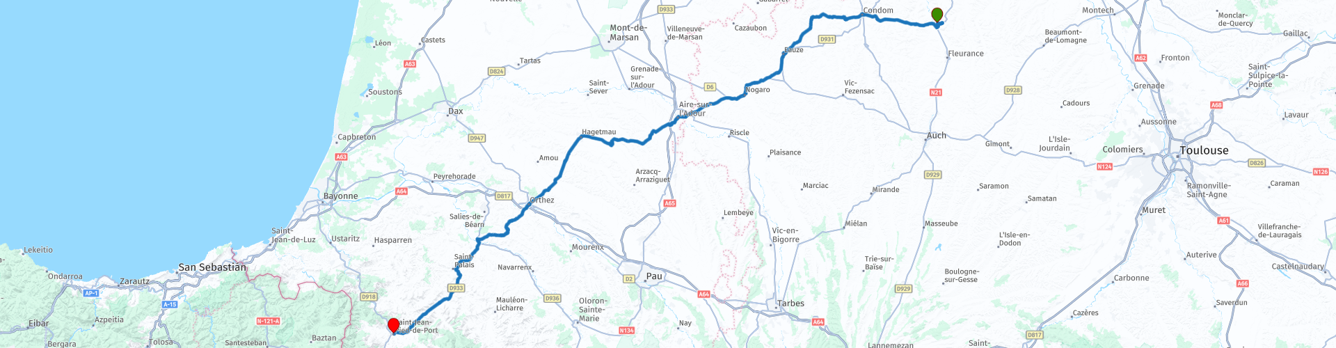
This trip follows the last section between Lectoure and Saint-Jean-Pied-de-Port
Today, the Via Podensis is best known for the beautiful nature you ride through. This and the medieval towns and villages with beautiful monuments you pass, earns a maximum rating of five stars.
 Share this route


Animation

Verdict


Duration
7h 37m

Mode of travel
Car or motorcycle

Distance
222.37 km

Countries

 RouteXpert Review
 In the Middle Ages, many pilgrims traveled along several well-trodden (but not always easy or safe) routes to the pilgrimage site of Santiago de Compostela, located in the northwestern corner of Spain. This city boasted of having the body of Saint James in its possession. The pilgrimage route through northern Spain formed a single line. Prior to that route, four major routes ran through France.
One of these supply routes starts from the Massif Central in France and runs through the Pyrenees to the Spanish border. This route is called the Via Podiensis and is 740 km long. The Via Podiensis passes through several southern French centres of great religious importance, such as Le Puy, Conques, Cahors, Moissac and Saint-Jean-Pied-de-Port.
In terms of landscape, it is a very varied route, which partly leads through gorge valleys (such as the Allier or Célé valley). It is a winding route, so you will not cover many kilometres per day. If you only do the part to Moissac, you will pass through the main religious sites. The last part leads through the plains located south of the Garonne and through the beginning of the Pyrenees. In terms of distance, you can roughly divide this route into three equal parts.
The last section, this route, runs from Lectoure to Saint-Jean-Pied-de-Port
Lectoure is one of the most beautiful places in the Gers department. It is a fortified city, surrounded by stone walls and is therefore a real bastide. Lectoure is located in the beautiful hills of the Gers and from the historic city you have a fantastic view over the countryside of this region. Lectoure was once the capital of the county of Armagnac. There are various possibilities to get acquainted with Armagnac, such as visiting one of the many Armagnac houses, where the drink is prepared. The Gers is also known for its gastronomy and many local regional products.
A little further on lies Condom, a pleasant little town in the north of the region. The name comes from the Gallic Condomagos, which means something like 'market at the confluence of rivers'. People have lived at this place on the river Baïse for more than two thousand years. In the Middle Ages, an important trade in Armagnac developed, mainly due to its strategic location on the river. In 1317, the town also received a bishop's seat, which immediately made the abbey church a cathedral. The drink Armagnac, named after the region of the same name, gradually became more and more famous, especially because pilgrims who walked the route to Santiago, which passed through Condom, brought the drink with them and praised it for its medicinal properties.
A few kilometres further on lies the village of Larressingle. It is the smallest medieval fortified town in France and is known as one of the most beautiful villages in France. It is well worth stopping to explore this little gem. The church is really interesting with a dome made of the very white limestone of the region and has great acoustics.
The next village Montréal-du-Gers is also on the list of most beautiful villages in France. What you should definitely also take a look at is the thirteenth-century church. This is a partly fortified church, of which one of the side walls is part of the defensive walls. An old city gate is also connected to the church.
In the next town, the coffee is finally ready, even though it is the capital of Armagnac. Eauze has a rich history and a gastronomic tradition that is second to none. The town is located on the border of Bas-Armagnac and Ténarèze, where the best Armagnac comes from. A few centuries ago, Eauze was the stronghold of the Elusates who offered the longest resistance to the Roman army of Julius Caesar. In the archaeological museum 'Le Trésor d'Eauze' you can admire a collection of no less than 28,000 coins from that period. Later, several great names from history, such as musketeer d'Artagnan and King Henri IV, left their mark on Eauze.
The most interesting part of Aire-sur-l'Adour is located south of the river Adour. Especially on Tuesdays and Saturdays, a busy market life brightens up the town. The pilgrims brought their food supplies and their perseverance here. So a reason to have lunch here. From here Santiago-de-Compostela was still more than 1000 km to walk. The city cathedral has a stylish interior with an 18th century organ. The church Ste.-Quitterie on the hill 'Mas' is also a religious stop.
The town of Orthez was the capital of the Béarn for two centuries. The photogenic Pont Vieux over the Ousse mountain stream and the elegant house of Jeanne d'Albret are particularly worth a visit and if you visit the 13th century Moncade keep you will surely find a place to stop for a drink along the way.
In Sauveterre, another fuel stop is planned for you before the last stretch to Saint-Jean-Pied-de-Port. You are now in the middle of the Pyrenees. Around St.-Jean-Pied-de-Port, the peaks rise to around 1200 metres. Not only pilgrims, but also Celts, Romans and Arabs have passed through the mountains via this mountain post. Some medieval parts of the Notre-Dame church have been preserved. The most beautiful street, the Rue de la Citadelle, has stately buildings. The French part of the pilgrimage route continues for another 8 km. Then the dusty, dry Spanish part begins, another 800 km to the tomb of Saint James.


 Links
Links  Usage
Usage Want to download this route?
You can download the route for free without MyRoute-app account. To do so, open the route and click 'save as'. Want to edit this route?
No problem, start by opening the route. Follow the tutorial and create your personal MyRoute-app account. After registration, your trial starts automatically.  Disclaimer
Use of this GPS route is at your own expense and risk. The route has been carefully composed and checked by a MyRoute-app accredited RouteXpert for use on TomTom, Garmin and MyRoute-app Navigation.
Changes may nevertheless have occurred due to changed circumstances, road diversions or seasonal closures. We therefore recommend checking each route before use.
Preferably use the route track in your navigation system. More information about the use of MyRoute-app can be found on the website under 'Community' or 'Academy'.

Occitanie
About this region
Occitanie (French pronunciation: [ɔksitani] (listen); Occitan: Occitània [utsiˈtanjɔ]; Catalan: Occitània [uksiˈtaniə]), Occitany or Occitania (), is the southernmost administrative region of metropolitan France excluding Corsica, created on 1 January 2016 from the former regions of Languedoc-Roussillon and Midi-Pyrénées. The Council of State approved Occitanie as the new name of the region on 28 September 2016, coming into effect on 30 September 2016.The modern administrative region is named after the larger cultural and historical region of Occitania, which corresponds with the southern third of France. The region Occitanie as it is today covers a territory similar to that ruled by the Counts of Toulouse in the 12th and 13th centuries. The banner of arms of the Counts of Toulouse, known colloquially as the Occitan cross, is used by the modern region and is also a popular cultural symbol. In 2015, Occitanie had a population of 5,839,867.
Read more on Wikipedia
View region
 Statistics
  81
81Amount of RX reviews (Occitanie)
 30453
30453Amount of visitors (Occitanie)
 4256
4256Amount of downloads (Occitanie)
 Route Collections in this region
 25 Magnificent trails in France
This MRA route collection contains 25 beautiful motorcycle routes in different parts of France, such as the Ardennes, the Alsace, Vercors, the Drôme, the Ardèche, Cote d'Azure, Gorges du Verdon, the Ariège, the Dordogne and Brittany.
The routes have been carefully created by Bert Loorbach, who is an enthusiastic motorcyclist himself. He lived in France for a year and a half, during which time he devoted himself to mapping the unknown and beautiful back roads of France especially for motorcyclists.
The routes are bundled in the Motortourgids France part 1 of Kosmos publishing house and now also available in MyRouteApp.
I have taken over the routes in MRA and sometimes adjusted them slightly to make them even more interesting for the motorcyclist.
View Route Collection
24 Magnificent trails in France
It is clear that France is one of the most beautiful and best touring countries. It offers an incredibly varied landscape with good roads and a pleasant climate. It is not for nothing that you see so many motorcyclists there. My previous collection of 25 routes in France (25 Magnificent routes in France) were based on the route descriptions from the Motortourgids France part 1 made by Bert Loorbach.
This collection of 24 routes comes from Motortourgids France part 2. In this collection, a difference has been made between approach routes and motorcycle tours in a certain area. The approach routes can also be used in combination with the routes from Motortourgids France part 1
The routes are sometimes slightly adjusted based on the tips that Bert Loorbach gives in his description, or because of another place to spend the night, or to reach the minimum length of 2 hours for the MRA Library. For each route, the review contains a more detailed description, including options to stay overnight or places of interest along the way, which are also indicated with a POI and if possible with a short description.
Two or more routes have been created for a number of areas, such as for Burgundy, Auvergne, The Alps, Tarn and Cévennes and Nord-Pas de Calais. These routes can be nicely combined in a multi-day trip.
View Route Collection