Auvergne from Arlempdes

This route was brought to you by:
RouteXpert Jan Koelstra - Senior Rx
Last edit: 28-04-2025
 Route Summary
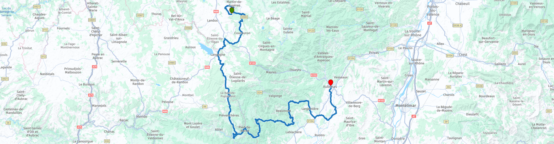
 In the southeast of the Auvergne, bordering the Cevennes, lies a beautiful holiday area: Les Monts de l'Ardèche.
The 200km ride through the southern Auvergne, starting in Arlempdes and ending in Aubenas in the Ardèche, is an absolute must. Along the way you will discover the hidden gems of this region, from medieval castles to charming villages that have defied time.
From the above follows a five star rating for this trip; it actually shows all aspects that you can expect from this tour.
 Share this route


Animation

Verdict


Duration
7h 36m

Mode of travel
Car or motorcycle

Distance
197.42 km

Countries

 RouteXpert Review
 Arlempdes is such a character village. It is situated on a volcanic rock high above the Loire in an area where you have to go out of your way to meet a foreign tourist. Despite its small size, the village does have a castle, or at least the remains of one, which at least determines the appearance of the village.
Arlempdes is built on a bend in the Loire gorge, which here is no more than a mountain stream of crystal-clear water. The village stands halfway up a volcanic peak around which the river flows.
The village seems deserted, without being abandoned. No one to be seen at the castle and the gates are closed. A faded sign tells you that you can buy entrance tickets at the restaurant, but there was no one to be found there either. The church was closed. The exterior has a robust appearance with a flat facade that you often see in this part of the Auvergne. At the top hang three bells in the open air, there is room for a fourth bell but it is no longer there. The square in front of the church looks good and is closed off on one side by the gatehouse that provides access to the village. However small, Arlempdes does have a museum, an eco-museum according to the description. Unfortunately that was also closed. Apparently also on holiday or a very long lunch break.
On the way to Pradelles you will pass several castles and a petrol station. The castle of Beaufort was built at the beginning of the 13th century and has been besieged many times over the centuries. Situated on a rocky peak on the banks of the Loire, it reveals a square plan with a dwelling and a large horseshoe-shaped tower. It is still possible to make out a section of the surrounding wall. It is a private property open to the public and houses a permanent medieval building site, including a fresco workshop, a stonemasonry and a cabinet-making workshop. The castle of Soubreys lies slightly off the road, hidden behind the houses along the road and thus no longer retains its former status. You can fill up on petrol just outside Coucouron.
When you arrive in Pradelles, you might think it is a transit village along the Route Nationale, where nothing ever happens. But appearances can be deceiving. A viewpoint is located on the west side of the village and on the way you come to a nice neighborhood with beautiful quiet streets. There is a beautifully preserved historic center. In the village, among other things, the Romanesque chapel Notre Dame de Toute Grâce, rebuilt in the 17th century, the Rochely tower and two fortified gates from the 14th century have been preserved. One of them is called Jeanne de la Verdette, in honor of the woman who defended the city in 1588.
A little further on, in the village of Langogne, the wool museum "filature des Calquières" is listed as a historical monument. The workshop is located on the banks of the Langouyrou, a tributary of the Allier. This lively museum tells the story of the textile industry in Lozère and also the different stages in wool processing. Here you can discover a traditional profession, such as carder, spinner or weaver and admire a set of unique machines from 1850, which still function thanks to the large wheel of the mill with the power of wild water! An exhibition space on weaving professions and a craft shop with wool clothing are a nice way to end your discovery of this amazing industrial heritage. After visiting the museum, you can visit the main monuments of Langogne, including the Romanesque church from the 12th century and the picturesque corn exchange from the 18th century, where a market is now held every Saturday morning.
Out of nowhere, the medieval fortified village of La Garde-Guérin appears. The village is located in a rugged mountain area, where vast plains and steep mountains alternate and on a plateau above the Gorges de Chassezac. Here with a cup of coffee in hand, this provides spectacular views. The defensive wall of the village is still clearly recognizable and the most visible are the remains of the castle of which a tower and some other buildings are still standing. Since the village was built in a strategic place, you have a beautiful view of the surroundings that is quite spectacular. A sign at the castle points you the way to a place with an even more beautiful view 15 minutes walk away.
La Garde-Guérin has a slightly different history than most Beaux Villages. There is no monastery or lord of the castle from which the village originated, but highwaymen and bandits who are the reason for the foundation of this settlement. How is that? La Garde-Guérin is located on the old Roman road between the Mediterranean and the Auvergne. This route was still used long after the Roman Empire had fallen and was the work area of gangs of highwaymen who terrorized traffic. In the twelfth century, the Bishop of Mende had had enough and decided to set up a permanent army to guard the road. The men who had been mustered built La Garde-Guérin as a base where every rider was given a house. The users of the road had to pay a toll for their safety and so the use of the road continued to cost money. A custom that is still very common in France.
After a while you get a nice view over a big lake. This is the reservoir of Villefort. Behind an impressive dam a beautiful lake of 137 hectares has been formed. You can enjoy the beach or many water sports activities. You can walk all around the lake on a seven km long hiking trail.
After the dam, turn left onto the road to the village of Pied-de-Borne and then along the rivers L'Argentière and La Thines to the village of Thines of the same name.
The turn to the church of Notre-Dame de Thines is rewarding. Here stands a beautiful church with Romanesque architecture and a monumental staircase to the main entrance. Built between 1170 and 1190 by the Benedictines of the Saint-Chaffre du Monastier Abbey. The sculpted lintel of the church shows detailed biblical scenes, including the entry into Jerusalem and the arrest of Jesus in characteristic Romanesque style. The building is located on pilgrimage routes to Le Puy-en-Velay and Santiago de Compostela.
It continues to tack through the National Natural Park of the Monts d'Ardèche. A very attractive area through the valleys, along the babbling brooks with suddenly a view. Here are picturesque hamlets one by one, hardly villages to be called and they are always nice, although lonely and of course campsites.
Then suddenly a town appears: L'Argentière-la-Bessée, Largentière for short.
In the second half of the 19th century, the town was a very busy centre thanks to the silver mines that were located here. This continued until the beginning of the 20th century, with a brief revival thanks to aluminium mining. By 1910, all mining activity had ceased. But tourism has also provided a solution here to counteract the decline and run-out.
As you walk through the picturesque alleys of the old medieval town, take note of the beautiful houses with sandstone facades, but also the arcades, mullioned windows and charming doors during your visit. The castle dominates the entire town. Formerly owned by the Bishop of Viviers, it was sold in 1716 to the Count of Brison, who did a lot of work to make it more comfortable. The square keep or Bastide de Bonnegarde of the castle dates back to the 12th century. Spared by the Revolution, the complex housed a tribunal, a prison and finally became the local hospital.
The church of Notre-Dame des Pommiers was built at the end of the 12th century, the beginning of the 13th century. Inside is a 13th-century sarcophagus and a 15th-century pulpit. A special detail: on top of a cornice is placed the skull of the counter-revolutionary Count of Saillans in 1792. The well-preserved Porte des Récollets from the 16th century is a remnant of the old ramparts with the bridge that gives access to the old city. Also discover the Montée Mazon, an access path, built in 1888 with stones from the old ramparts, the 19th-century courthouse and the Renaissance town hall. The canal, visible from the Récollets bridge, was used to supply the shops with water. You can of course eat well here in one of the restaurants where local products such as goat cheese and asparagus are on the menu. Lunch time!
Balazuc is situated high on a rock above the Ardèche river. Every day feels like a holiday here. The climate is wonderfully warm, the streets picturesque, the food good and you can always cool off in the river. Thanks to the tourists, the region is prosperous. It is hard to imagine, but once there were no tourists here and there was deep poverty. In the nineteenth century, the region received an economic boost with the introduction of the silkworm. However, this revival proved to be temporary and things only really took off here when people started going on holiday en masse after the sixties of the last century. The history of Balazac is of course much older. In the Middle Ages, there was not always a party here either, because the village was more than once on the front line of the wars that were fought here. The castle and the fortified Romanesque church also date from that time. The narrow streets and alleys form a maze where it is wonderful to walk.
Vogüé is also built along the Ardèche river on a spot where the bank has the shape of a natural amphitheatre. The castle is built high against the rocks with the village and church below it, all the way down the beach completes the picture. In addition to culture, you can swim here and go down the river in a canoe. This village is a natural beauty with its beautiful houses, the church and of course the castle. The latter stands out because of its simple shapes with four round towers on each corner. The village itself is cosy with its narrow streets and arcades and you have a beautiful view of the river; an invitation for a drink.
Finally, you will end your trip in Aubenas. The castle, built in the 12th century, has been classified as a historical monument since 1943. The Dôme Saint Benoît, characterized by its exceptional dome, houses collections of religious artefacts such as the mausoleum of Marshal d'Ornano. Today, this place is considered a perfect base for a wonderful holiday in the Ardèche. Aubenas is ideally located in relation to the many sights that the Ardèche has to offer, such as the grotte de Saint-Marcel d'Ardèche and the grotte de la Madeleine, but also the most beautiful places in the Gorges de l'Ardèche. There is also plenty to do and experience in the town itself. There are countless beautiful old medieval streets, beautiful old buildings and many cozy shops and restaurants. It is therefore not without reason that Aubenas is considered one of the most popular holiday destinations in the whole of the South of France. Gourmets should not miss the weekly market to taste the local gastronomy! Every Saturday from 9am to 1pm, market gardeners, producers and local craftsmen are ready to let you discover or taste their products: seasonal fruit and vegetables, regional products, handmade creations and culinary specialities from the region. Perhaps you will also feel like it after this ride. In any case, there is plenty of choice here!


 Links
Links  Usage
Usage Want to download this route?
You can download the route for free without MyRoute-app account. To do so, open the route and click 'save as'. Want to edit this route?
No problem, start by opening the route. Follow the tutorial and create your personal MyRoute-app account. After registration, your trial starts automatically.  Disclaimer
Use of this GPS route is at your own expense and risk. The route has been carefully composed and checked by a MyRoute-app accredited RouteXpert for use on TomTom, Garmin and MyRoute-app Navigation.
Changes may nevertheless have occurred due to changed circumstances, road diversions or seasonal closures. We therefore recommend checking each route before use.
Preferably use the route track in your navigation system. More information about the use of MyRoute-app can be found on the website under 'Community' or 'Academy'.

Occitanie
About this region
Occitanie (French pronunciation: [ɔksitani] (listen); Occitan: Occitània [utsiˈtanjɔ]; Catalan: Occitània [uksiˈtaniə]), Occitany or Occitania (), is the southernmost administrative region of metropolitan France excluding Corsica, created on 1 January 2016 from the former regions of Languedoc-Roussillon and Midi-Pyrénées. The Council of State approved Occitanie as the new name of the region on 28 September 2016, coming into effect on 30 September 2016.The modern administrative region is named after the larger cultural and historical region of Occitania, which corresponds with the southern third of France. The region Occitanie as it is today covers a territory similar to that ruled by the Counts of Toulouse in the 12th and 13th centuries. The banner of arms of the Counts of Toulouse, known colloquially as the Occitan cross, is used by the modern region and is also a popular cultural symbol. In 2015, Occitanie had a population of 5,839,867.
Read more on Wikipedia
View region
 Statistics
  83
83Amount of RX reviews (Occitanie)
 32278
32278Amount of visitors (Occitanie)
 4416
4416Amount of downloads (Occitanie)
 Route Collections in this region
 25 Magnificent trails in France
This MRA route collection contains 25 beautiful motorcycle routes in different parts of France, such as the Ardennes, the Alsace, Vercors, the Drôme, the Ardèche, Cote d'Azure, Gorges du Verdon, the Ariège, the Dordogne and Brittany.
The routes have been carefully created by Bert Loorbach, who is an enthusiastic motorcyclist himself. He lived in France for a year and a half, during which time he devoted himself to mapping the unknown and beautiful back roads of France especially for motorcyclists.
The routes are bundled in the Motortourgids France part 1 of Kosmos publishing house and now also available in MyRouteApp.
I have taken over the routes in MRA and sometimes adjusted them slightly to make them even more interesting for the motorcyclist.
View Route Collection
24 Magnificent trails in France
It is clear that France is one of the most beautiful and best touring countries. It offers an incredibly varied landscape with good roads and a pleasant climate. It is not for nothing that you see so many motorcyclists there. My previous collection of 25 routes in France (25 Magnificent routes in France) were based on the route descriptions from the Motortourgids France part 1 made by Bert Loorbach.
This collection of 24 routes comes from Motortourgids France part 2. In this collection, a difference has been made between approach routes and motorcycle tours in a certain area. The approach routes can also be used in combination with the routes from Motortourgids France part 1
The routes are sometimes slightly adjusted based on the tips that Bert Loorbach gives in his description, or because of another place to spend the night, or to reach the minimum length of 2 hours for the MRA Library. For each route, the review contains a more detailed description, including options to stay overnight or places of interest along the way, which are also indicated with a POI and if possible with a short description.
Two or more routes have been created for a number of areas, such as for Burgundy, Auvergne, The Alps, Tarn and Cévennes and Nord-Pas de Calais. These routes can be nicely combined in a multi-day trip.
View Route Collection