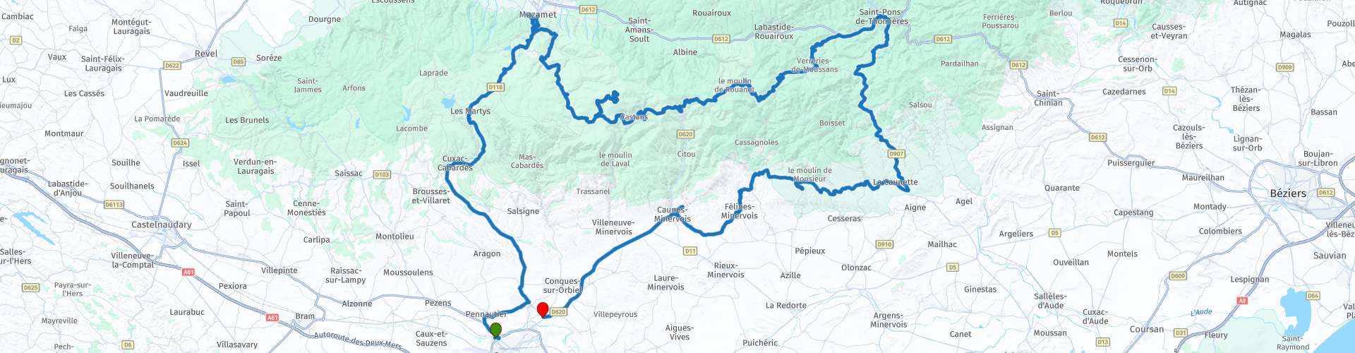
AUDE Carcassonne Pic de Nore Carcassonne

This route was brought to you by:
RouteXpert Steve Montreal
Last edit: 09-04-2024
 Route Summary
 It is one of our favourite routes and truly earns its five star rating by thrilling, captivating and enthralling at different stages along the way.
Starting near Carcassonne, it takes us north over part of the Massif Central, called the Montaigne Noire, to Mazamet, before searching out the highest point in the Aude at the Pic de Nore at 1211m.
On a clear day, it is the perfect spot for a picnic, so travel prepared.
The route then descends into St.Pons de Thomieres, before again crossing the Montaigne Noire on some marvellously flowing riding roads to historic Minerve, the pink marble of Caunes-Minervois, and finally back to Carcassonne.
So, fellow riders, gear up and explore this enchanting region—it’s a ride you won’t soon forget! ????️????
Riding Time = 4hours 10minutes
 Share this route


Animation

Verdict


Duration
9h 21m

Mode of travel
Car or motorcycle

Distance
200.02 km

Countries

 RouteXpert Review
 First we head towards Château Pennautier, a hidden gem just a few km away.
The Château, dating back to the 17th century, is often described as ‘Versailles in miniature’.
Construction began on the château in 1620 at the request of Bernard Reich de Pennautier, who was Treasurer of the Estates of Languedoc. The building work was later continued by his son who asked Le Vau, the architect of Versailles, to erect the wings of the château, while Le Notre was entrusted with designing the French gardens.
A short distance later you will cross the ‘New Bridge’ in Villegailhenc.
The original bridge was washed away as flash floods swamped the area in October 2018. The Trapel & Aude rivers burst their banks at night causing the loss of twelve lives in the region.
The road then unfolds before us as we climb up on the swooping tarmac into the Montaigne Noire.
At the 810m summit at Col de Sainte-Saraille, you cross into the Tarn and start the winding descent into Mazamet.
Mazamet finds its origins in Hautpoul, a perched village 600m high overlooking the city and founded in 413 by the Visigoths. In the 13th century, Hautpoul was besieged and the inhabitants were displaced, they moved down the valley and established Mazamet.
From the 18th century, the city developed a flourishing textile and wool industry.
This is the town that was chosen to make the uniforms for Napoleon’s army.
To this day Mazamet is known for its excellent in textiles and leather goods are produced here for companies such as Louis Vuitton and Smythson of London.
Leaving Mazamet following the Arnette River, the energetic among you have the opportunity to walk the climb up to ‘La Passerelle’.
This 140 m long Himalayan footbridge slung 70m above the precipitous Gorges de l’Arnette links Mazamet to the medieval village of Hautpoul.
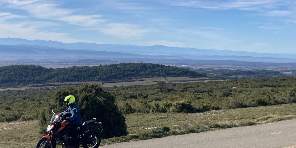
Our next destination is the majestic Pic de Nore, the highest point in the Aude at 1,211m, so as we ascend the air grows crisper and the views become more breathtaking.
The summit is dominated by the 102m transmission tower which broadcasts radio and TV signals across the region.
You will be rewarded with panoramic vistas of the surrounding valleys and forests and, on a clear day, the perfect setting for a lunchtime picnic.
Cyclists also love the challenge of reaching the peak from both Mazamet and Villegly on timed climbs that really test their mettle.
The Tour de France passed over the summit for the first time on Stage 15 of the 2018 tour.
Retracing our steps to Pradelles-Cabardes, our winding descent eventually leads us to the charming town of St Pons de Thomieres.
The subterranean Jaur River rises here from a 6-metre-high cavity at the bottom of a 15-metre cliff.
Often explored in the 19th century and made accessible to visitors at certain times, this spring has a sacred aura.
Legend has it that it was once a monster that was petrified by the gods.
The history of Saint-Pons is known from the foundation of the Benedictine Abbey by Count Raymond Pons of Toulouse, in 936.
The abbey was built on the left bank of the river Jaur and entrusted to Benedictine monks from Aurillac. The town of Saint-Pons developed around the church and the vast abbey buildings & fortified town was built.
On the right bank, was situated the lesser town of Thomières, with its own ramparts and streets lined with shops. In 1170, the monastery, and probably part of the town, were plundered by the Protestants, and suffered serious destruction. In the 17th Century, the two towns united under the name of Saint Pons de Thomières. The Romanesque abbey church became the present cathedral.
It takes its dedication, like the town and the abbey, from Saint Pontius of Cimiez.
It is particularly known for the carvings on and around the portals.
After a coffee or snack in St.Pons, we head south to again cross over the Montaigne Noire, this time via the 634m Col de Sainte Colombe along some wonderful twisting, and beautifully surfaced tarmac, towards Minerve.
Perched on a rocky outcrop, Minerve is steeped in legend and tragedy and is the namesake of the Minervois wine region.
As you approach the village you will see a recreation of a trebuchet used against its walls during the Albigensian Crusade
Minerve was a Cathar stronghold during the Albigensian Crusade.
The village was besieged by Simon de Montfort, 5th Earl of Leicester, the attacking army besieged the village for six weeks before it surrendered.
Four catapults or trebuchets were set up around the ramparts, three to attack the village itself and the largest, known as Malvoisine or "bad neighbour", to destroy the town's well.
With the town's only water supply cut off, the Commander of the 200-strong garrison, Viscount Guilhem of Minerve, gave in and negotiated a surrender in order to have the villagers and himself spared from death.
However, 140 Cathars refused to give up their faith and convert, being burned to death at the stake.
You may not have time to visit Minerve today but put it on your list for later.
After Minerve you will be following the Gorges de la Cesse and du Brian which is popular with climbers.
The limestone plateau and the gorges have been shaped by water, which has produced this irregular limestone region with sinkholes, underground streams, and caverns with caves and faults in which water infiltrates and circulates underground. The Cesse has the peculiarity of disappearing on sunny days for about 17km. It abandons its course above ground, upstream from Minerve, and reappears in Agel at the resurgence called Le Boulidou.
It then continues its course and flows into the Aude at Sallèle d'Aude after crossing the Canal du Midi.
Later, take a moment at the Siran viewpoint and marvel at the views across the Minervois to the Corbieres, then take the short detour to discover the ‘Curiosité de Lauriole’.
There is a mystery that attracts curious and sceptical people every year.
The road here seems to go up while it goes down... or the other way round!
This "descending slope" is indicated by the sign "Curiosité de Lauriole". A special configuration of the surrounding terrain creates an optical illusion. The result is very curious, and you can experience it with a ball, a bottle, or a motorcycle in neutral.
Caunes-Minervois is a small medieval town and commune, it is known particularly for its ancient Abbey, dating from the 8th century, and the outstanding red marble that has been quarried locally from Roman times.
The marble extracted from the quarries here was used extensively during the reign of Louis XIV to decorate wealthy residences.
It was from here that the marble for the Chateau de Versailles, the Louvre and the Arc de Triomphe in Paris was quarried.
Leaving Caunes, on the final leg of our journey, we head back to Carcassonne and the Canal du Midi for our last destination and the end of the route at the Ecluse de Fresquel.
There are two locks here, the 'Simple' & the 'Double'. The upstream lock is a double lock, following a small intermediate basin, and the downstream lock is a single lock.
The Fresquel Aqueduct is one of several aqueducts on the Canal du Midi. Until its building, the canal crossed the River Fresquel on the level. It was built in 1802–1810 when the canal was rerouted to pass through Carcassonne.
I hope that you enjoy your tour on this lovely route.
Ride Safe.

 Links
Links  Usage
Usage Want to download this route?
You can download the route for free without MyRoute-app account. To do so, open the route and click 'save as'. Want to edit this route?
No problem, start by opening the route. Follow the tutorial and create your personal MyRoute-app account. After registration, your trial starts automatically.  Disclaimer
Use of this GPS route is at your own expense and risk. The route has been carefully composed and checked by a MyRoute-app accredited RouteXpert for use on TomTom, Garmin and MyRoute-app Navigation.
Changes may nevertheless have occurred due to changed circumstances, road diversions or seasonal closures. We therefore recommend checking each route before use.
Preferably use the route track in your navigation system. More information about the use of MyRoute-app can be found on the website under 'Community' or 'Academy'.

Occitanie
About this region
Occitanie (French pronunciation: [ɔksitani] (listen); Occitan: Occitània [utsiˈtanjɔ]; Catalan: Occitània [uksiˈtaniə]), Occitany or Occitania (), is the southernmost administrative region of metropolitan France excluding Corsica, created on 1 January 2016 from the former regions of Languedoc-Roussillon and Midi-Pyrénées. The Council of State approved Occitanie as the new name of the region on 28 September 2016, coming into effect on 30 September 2016.The modern administrative region is named after the larger cultural and historical region of Occitania, which corresponds with the southern third of France. The region Occitanie as it is today covers a territory similar to that ruled by the Counts of Toulouse in the 12th and 13th centuries. The banner of arms of the Counts of Toulouse, known colloquially as the Occitan cross, is used by the modern region and is also a popular cultural symbol. In 2015, Occitanie had a population of 5,839,867.
Read more on Wikipedia
View region
 Statistics
  83
83Amount of RX reviews (Occitanie)
 32278
32278Amount of visitors (Occitanie)
 4416
4416Amount of downloads (Occitanie)
 Route Collections in this region
 25 Magnificent trails in France
This MRA route collection contains 25 beautiful motorcycle routes in different parts of France, such as the Ardennes, the Alsace, Vercors, the Drôme, the Ardèche, Cote d'Azure, Gorges du Verdon, the Ariège, the Dordogne and Brittany.
The routes have been carefully created by Bert Loorbach, who is an enthusiastic motorcyclist himself. He lived in France for a year and a half, during which time he devoted himself to mapping the unknown and beautiful back roads of France especially for motorcyclists.
The routes are bundled in the Motortourgids France part 1 of Kosmos publishing house and now also available in MyRouteApp.
I have taken over the routes in MRA and sometimes adjusted them slightly to make them even more interesting for the motorcyclist.
View Route Collection
24 Magnificent trails in France
It is clear that France is one of the most beautiful and best touring countries. It offers an incredibly varied landscape with good roads and a pleasant climate. It is not for nothing that you see so many motorcyclists there. My previous collection of 25 routes in France (25 Magnificent routes in France) were based on the route descriptions from the Motortourgids France part 1 made by Bert Loorbach.
This collection of 24 routes comes from Motortourgids France part 2. In this collection, a difference has been made between approach routes and motorcycle tours in a certain area. The approach routes can also be used in combination with the routes from Motortourgids France part 1
The routes are sometimes slightly adjusted based on the tips that Bert Loorbach gives in his description, or because of another place to spend the night, or to reach the minimum length of 2 hours for the MRA Library. For each route, the review contains a more detailed description, including options to stay overnight or places of interest along the way, which are also indicated with a POI and if possible with a short description.
Two or more routes have been created for a number of areas, such as for Burgundy, Auvergne, The Alps, Tarn and Cévennes and Nord-Pas de Calais. These routes can be nicely combined in a multi-day trip.
View Route Collection