Arctic Coast Way Day 5 Husavik Raufarhofn

This route was brought to you by:
RouteXpert René Plücken (MRA Master)
Last edit: 16-03-2021
 Route Summary
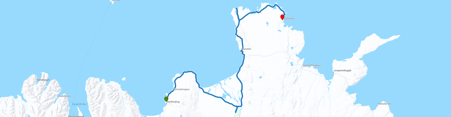
 The Arctic Coast Way starts in Hvammstangi in the North West and ends in Bakkafjörður in the North East. This approximately 900 kilometer long “Off the Beaten track” route passes through rugged North Iceland and follows the beautiful Fjord coast.
Driving the Arctic Coast Way is different from what you might be used to. It is a true off the beaten track route that takes you through beautiful remote landscapes. This means leaving civilization behind in the spirit of adventure and exploration.
We drive large parts on unpaved roads (about 1/3 part), sometimes with large holes, so this route is only suitable for Adventure or Off Road motorcycles or for cars with 4x4 drive. Drive slowly to enjoy the magical surroundings but because of the sheep and birds that can walk on the road.
The route runs close to the Arctic Circle and many stops are planned along the way to visit Iceland's many highlights. A number of examples are the many waterfalls, glaciers, fishing villages and fjords. In some cases you have to take a walk (hike), these can influence the planning of the rides, so keep that in mind. Due to the slower speed on the unpaved roads and the sights en route, the routes have been kept short.
Enjoy the freedom along the way, but respect nature and keep in mind that wild camping is prohibited, you are only allowed to camp on campsites or with the permission of the owner on his private property. All villages along the route have camping options. All campsites have rubbish bins and sanitary facilities. Do not drive off-road, but stay on the designated roads. Off-road driving is prohibited, with heavy fines.
This is the fifth day of the six-day Arctic Coast Way Roadtrip which I rate with 5 ***** Stars for the beautiful nature, beautiful places to visit and the adventurous aspect.
Enjoy!
 Share this route


Animation

Verdict


Duration
11h 44m

Mode of travel
Car or motorcycle

Distance
173.12 km

Countries

 RouteXpert Review
 There are a number of beautiful points along the route for which we have to walk a lot. There is also the possibility to visit a number of museums and we visit Vatnajokull National Park. Make sure you bring plenty of water and food.
We leave Húsavik early and drive North, at RP2 we can visit the museum in Mánárbakki. This museum was opened on June 18, 1995 in the Þórshamri house that was moved from Húsavík to Mánárbakki.
The Manarbakki Farm is the site of a unique private museum and meteorological station. This private museum is small but very nice and houses an interesting collection of household items. The old and funny but fun things in life remind us that time is a wonderful thing. The owners will open the museum to visitors upon request.
The next shorter stop is De Hringsbjarg cliff (RP3), which is a towering 60 meter cliff on the east side of the Tjörnes peninsula in North East Iceland. From the cliff you have a spectacular view of Fjallahöfn and the vast plains of Kelduhverfi province, which divide the Tjörnes peninsula and the Öxarfjörður fjord. During Iceland's puffin season, this is an excellent location to view this delightful bird with its colorful beak and orange legs.
We continue to RP4, where we visit Asbyrgi Gorge and Botnstjörn Pond.
Take a walk through the Ásbyrgi Glacier Gorge and the forest. The horseshoe-shaped gorge is part of the Vatnajökull National Park and is ~ 3.5 km long and over 1 km wide.
Over half its length, the gorge is divided in the middle by a striking 25 meter high rock formation called Eyjan ("the island"), from which a wide landscape can be seen. The steep walls of the gorge are formed by cliffs up to 100 meters high. Inside the gorge is a forest of birch and willow trees.
We briefly leave the Arctic Coast Way to visit The Earthquake Center (RP6) in Kópasker. It mainly commemorates the Kópasker earthquake, which occurred on January 13, 1976 and must have been about 6.3 on the Richter scale. It was the largest earthquake in the seismic cycle that had been continuous since December 20, when the Krafla fires started. In Kópasker we can also take a short break at the grocery shop with café (RP7).
The first hike is planned at Rauðinúpur Cliff (RP11). To do this, turn left at RP10 and drive down to Núpskatla farm. Don't forget to close the gate you have to go through. From the parking lot at the farm you can walk to the cape in about 30-45 minutes.
Keep in mind that you can be attacked by the Arctic tern, you can borrow a stick from the parking lot to protect your head from the attacks, an umbrella works well too.
Rauðinúpur Cliff has a beautiful red color, the color comes from red lapilli. Hike up the slope leading to a lighthouse and two beautiful Sea Stacks called "Karlinn" and "Sölvanöf".
The second hike is planned at the Hraunhafnartangi (RP13). The walk takes 30 minutes. This is the second northernmost point on mainland Iceland and is notable for its beautiful sleek Hraunhafnartangi lighthouse.
After about 10 kilometers we turn right to view a special building; “The Arctic Henge” (RP14) is comparable to its old predecessor “The Stonehenge”. This newly built monument is also a huge sundial, aimed to capture the sun's rays and project the shadows in precise locations. A beautiful building!
We drive to the Coffee Shop Kaupfélagið Raufarhöfn (RP15) where we have a drink.
We fill up our bikes at the gas station for the last ride, which is scheduled for tomorrow, before pitching the tent at Camp Site Raufarhafnar (RP16), today's end point.


 Links
Links  Usage
Usage Want to download this route?
You can download the route for free without MyRoute-app account. To do so, open the route and click 'save as'. Want to edit this route?
No problem, start by opening the route. Follow the tutorial and create your personal MyRoute-app account. After registration, your trial starts automatically.  Disclaimer
Use of this GPS route is at your own expense and risk. The route has been carefully composed and checked by a MyRoute-app accredited RouteXpert for use on TomTom, Garmin and MyRoute-app Navigation.
Changes may nevertheless have occurred due to changed circumstances, road diversions or seasonal closures. We therefore recommend checking each route before use.
Preferably use the route track in your navigation system. More information about the use of MyRoute-app can be found on the website under 'Community' or 'Academy'.