Zuidelijk van Trentino

This route was brought to you by:
RouteXpert Hans van de Ven (Mr.MRA)
Last edit: 11-02-2023
 Route Summary
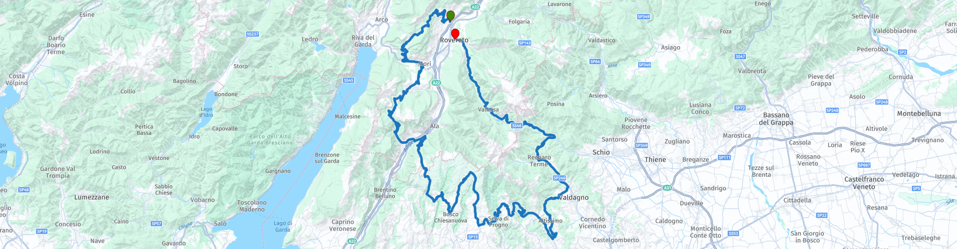
 Start: Rovereto
Finish: Rovereto
The route made the same for TomTom, Garmin and MyRoute-app Navigation users.
If you want to ride this TT, keep the info below in mind:
- No mountain experience
- Tour
Source: Promoter 07, September / October 2018.
 Share this route


Animation

Verdict


Duration
5h 49m

Mode of travel
Car or motorcycle

Distance
230.41 km

Countries

 RouteXpert Review
 Passes and mountain roads: Passo Bordola (1250 m), mountain roads through the Monte Baldo massif, Passo Fittanze di Sega (1399 m), Monte Lessini mountain road, Passo Xon (671 m), Passo Pian delle Fugazze (1159 m), mountain road Vallarsa / Rovereto.
This 5-star route is one of the 24 most beautiful Alpine routes in recent years!
Colored route points:
rp 1 - Starting point at Albergo Al Ponte
rp 4 - Passo Bordala
rp 10 - Passo di San Valentino
rp 12 - Coffee stop at Antica Trattoria Bar Alla Stazione
rp 15 - Passo delle Fittanze
rp 23 - Lunch stop at Pasticceria Peroni
rp 32 - Coffee stop at La Meridiana
rp 43 - Passo Xon
rp 44 - Tank stop at Sberze
rp 47 - Pian delle Fugazze
rp 49 - End point at Terrazza sul Leno
Route details:
- Winter closure: Monte Baldo has no official winter closure, the other roads are closed from November to May. Passo Fittanze di Sega is closed from November to May. Other pass roads in the Monte Lessini are temporarily closed in the snow.
- Alternative routes: Torbole and Riva are a few minutes' drive from Loppio for a cappuccino on the shores of Lake Garda.
- Ideal months: Late spring, early summer and fall.
- Driving pleasure: Passo Bordola and the road to Loppio, Monte Baldo, all roads in Monte Lessini. Recommended is the road between Foxi di Vallarsa and Rovereto. You should also do this cutter in the opposite direction (uphill).
- Landscape: Val di Cei, Gardasee, Monte Baldo, Monte Lessini, Pasubio massif.


 Links
Links  Usage
Usage Want to download this route?
You can download the route for free without MyRoute-app account. To do so, open the route and click 'save as'. Want to edit this route?
No problem, start by opening the route. Follow the tutorial and create your personal MyRoute-app account. After registration, your trial starts automatically.  Disclaimer
Use of this GPS route is at your own expense and risk. The route has been carefully composed and checked by a MyRoute-app accredited RouteXpert for use on TomTom, Garmin and MyRoute-app Navigation.
Changes may nevertheless have occurred due to changed circumstances, road diversions or seasonal closures. We therefore recommend checking each route before use.
Preferably use the route track in your navigation system. More information about the use of MyRoute-app can be found on the website under 'Community' or 'Academy'.