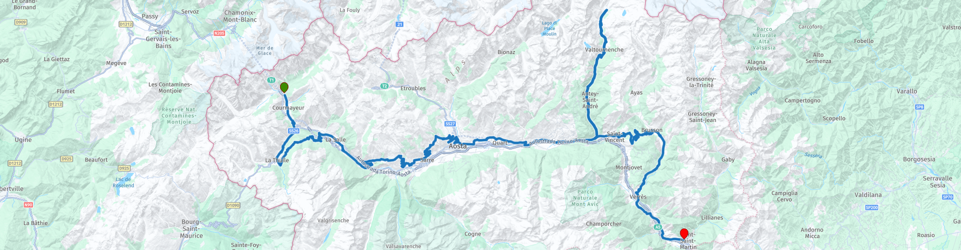
Courmayeur to Pont Saint Martin along the Valle dAosta

This route was brought to you by:
RouteXpert Nick Carthew - (MRA Master)
Last edit: 24-01-2024
 Route Summary
 The spectacular mountain views and historic sites makes this route worthy of the 5***** stars I have awarded it.
 Share this route


Animation

Verdict


Duration
5h 36m

Mode of travel
Car or motorcycle

Distance
223.58 km

Countries

 RouteXpert Review
 The smallest region in Italy encompasses the most beautiful and highest mountains in the area such as Mont Blanc, Monte Rosa, the Matterhorn and Gran Paradiso
This route is a feast for your eyes and has breathtakingly beautiful views along it's entire stretch. You are never far away from the river Dora Baltea that runs through the Valle d'Aosta. This 170 km river has its source in Mont Blanc area where the Dora di Val Ferret joins with the Dora di Val Veny. As the river travels through the Aosta Valley, the Dora Baltea River crosses through the city of Courmayeur, Aosta and Saint-Vincent, soon after, the river reaches the River Po, close to Chivasso.
The route starts from a nice hotel just on the Italian side of the Mont Blanc tunnel and soon crosses the river Dora Baltea and uses the Strada Statale 26 road which has some fantastic hairpin bends, tunnels and magnificent views as it makes it's way to La Thuile. Here you'll find a great little cafe with dedicated parking for motorcycles and a warm welcome. More great bends and the highest point of this route (Colle San Carlo at 1970 m) will be found as you make your way back to the Aosta Valley floor. This route avoids the major roads as much as it can in preference to the more twisty provincial roads. You will pass castles and have many opportunities to stop for photographs of the breathtaking views.
I have suggested a lunch stop at Aosta.
Aosta is an old Roman town at 583m above sea level, and the largest in the region with a population of 35,000. Full of things to see and do, it’s surrounded by magnificent mountains, including the Grand Combin and the Mont Vélan to the north, Emilius and the Becca di Nona to the south, and the Testa del Rutor to the west. The town was founded by the Romans in 25 BC at a geographical point where the physiographic catchment of the Dora Baltea reaches its maximum width, and where the main roads heading to France and Switzerland converge. The presence of the Piccolo and Gran San Bernardo Alpine hills makes Aosta an important strategic junction from a transport point of view (nowadays thanks to the Mont Blanc and Gran San Bernardo Tunnels). Rich in monuments from prehistoric, Roman, medieval and later times, Aosta makes a fascinating historical case study. There’s the megalithic area of Saint-Martin de Corleans; the Praetoria Gate, one of the few examples from Roman times still perfectly intact; the Theatre; the forum Cryptoporticus, the perimeter of the boundary walls almost completely intact; a well-preserved extra muros villa; and the magnificent Augustus’ Arch. Ancient roads, fountains, wash-houses, votive chapels, sundials, historical houses and courtyards are also in abundance.
There is an abundance of restaurants close to the Arco di Augusto to suit all tastes
At RP32 you have the option to ride to the Matterhorn mountain, a round trip of 1.5 - 2 hours with a coffee stop.
Thanks to its shape and its free-standing position, the Matterhorn is considered to be the epitome of a mountain. There is no better known mountain in the world whose natural shape is so close to a pyramid. 100 million years ago, enormous forces brought Africa closer to Europe. 50 million years later, as the rock masses folded and deformed, the Matterhorn was born from the rock thrusting upwards. The valley road leading to the Matterhorn has some incredibly beautiful views and is of course, completely different when you turn around and ride back down the other way.
After rejoining the Aosta valley the route heads into the hills again and on to the Colle di Joux, and at 1650 m it's the second highest peak of this route.
More beautiful views, twisty roads and castles bring you to perhaps the most imposing of all of the fortifications within the Aosta Valley; Fort Bard.
The fort, which is at the eastern entrance to the Aosta Valley, is located in a narrow gorge above the Dora Baltea river. It has been used for millennia to control the historic route between Italy and France. The current fortifications were built by Charles Albert of Savoy between 1830 and 1838. It replaced a 10th-century castle that had, itself, been built on an earlier structure founded by Theodoric I in the 5th century. The castle was under the control of the powerful local lords of Bard until the middle of the 13th century when ownership passed to the House of Savoy. Under their control, the defences were strengthened and improved. On May 14, 1800, a 40,000-strong French army was stopped by 400 Austro-Piedmontese soldiers at Fort Bard. They held the pass for two weeks, completely ruining Napoleon Bonaparte's plan of making a surprise attack on the Po Valley and Turin. When he heard the news, he named the fort vilain castel de Bard. Bonaparte then ordered the fort to be razed to the ground. It was not until 1830 that Charles Albert of Savoy, fearing new attacks from the French, ordered that the fort be rebuilt.
This route ends at Hotel Crabun which is just a few minutes away. Links for the start and end hotels can be found below this review and of course, there are many more choices of accommodation available.


 Links
Links  Usage
Usage Want to download this route?
You can download the route for free without MyRoute-app account. To do so, open the route and click 'save as'. Want to edit this route?
No problem, start by opening the route. Follow the tutorial and create your personal MyRoute-app account. After registration, your trial starts automatically.  Disclaimer
Use of this GPS route is at your own expense and risk. The route has been carefully composed and checked by a MyRoute-app accredited RouteXpert for use on TomTom, Garmin and MyRoute-app Navigation.
Changes may nevertheless have occurred due to changed circumstances, road diversions or seasonal closures. We therefore recommend checking each route before use.
Preferably use the route track in your navigation system. More information about the use of MyRoute-app can be found on the website under 'Community' or 'Academy'.