TTT 2018 05 Rondje Zeeland vanuit Spijkenisse

This route was brought to you by:
RouteXpert Hans van de Ven (Mr.MRA)
Last edit: 24-04-2021
 Route Summary
 This TTT are touring through the Netherlands with the occasional trip to Belgium, Germany or even Luxembourg, which are driven 6 to 7 times a year. The 1st around March and the last around October. These TTTs have a starting point, a pause location and an end point. It is nice to discover what you have not seen in your own country and which nice roads you did not know before.
This TTT is from 2018, so the route may differ slightly from the original.
I have checked all route points and, where necessary, placed them neatly on the road. Also, if necessary, I have further spaced the start point and end point of the route to avoid navigating directly to the end point and I added the POI files from the start and end point as well as possible pause location (s).
Finally, I made the route the same for TomTom, Garmin and MRA Navigation users.
Thanks to Promoter.
* Original route adjusted because there is a closed declaration on the Biertsedijk between 1 April and 1 October. Info: Dennis Hoogendonk & Rob Den Boer.
 Share this route


Animation

Verdict


Duration
5h 2m

Mode of travel
Car or motorcycle

Distance
158.27 km

Countries

 RouteXpert Review
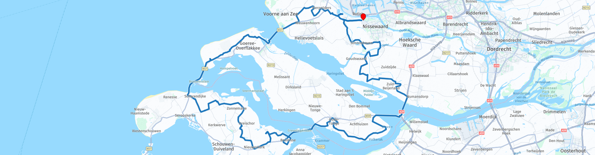
 Just after the start in Spijkenisse you will be directed to the coast as pleasantly as possible. Along Vierpolders, fully enjoy the landscape and chew on a name that means exactly what the hamlet suggests: space in the polder. Swirling on polder and dike roads with a view of vast fields that were once regularly irrigated with unwanted sea water. Nowadays, but especially in the summer, the connected islands are only flooded with tourists. Completely unhurried and brash on your motorcycle over land where people had to struggle for a long time. The ongoing battle against the sea began 15,000 years ago, even the Romans settled in the delta. The whims of the sea brought uncertainty, but prosperity rippled in the 15th and 16th centuries to cities such as Middelburg and Vlissingen. Hardened by the elements and a forced adaptability, that formed the character. In the meantime, the Eilandrijk is doing well in tourism and the engine is a permanent part of that.
On the Dammenweg you can smell the sea while driving, which will undoubtedly be detected by the increasing grins on tanned faces. Then on the N57 of Goeree-Overflakkee a beautiful view of the North Sea and on the other hand the Haringvliet as inland sea. You then drive on the Delta Works. A technical ingenuity, the construction of which started in 1960 and which permanently kept the salty danger off the sea. A welcome recommendation is a short stopover in the fishing port at the Binnenhaven. Colorful fishing boats with huge nets are a cool backdrop for a photo. Anyone who wants to indulge themselves at the sea banquet must pay extra attention to winged pirates. Loudly they drown the engine noise hungry and transform them into talented dive bombers in search of crust. So vigilance is required. The route takes you further through the polders, past sandy meadows and then through Ouddorp. There is ample parking space on the Brouwersdam, near Port Zeelande. The sea is literally open to you here. The perfect opportunity to enjoy the vast beaches or elevated terraces with panoramic views. Pay attention to the formation of sand on the asphalt of the Brouwersdam. The road usually extends straight. On the last part of this land dam you actually enter Zeeland.
Along Scharrendijke and Brouwershaven you tap on Schouwen-Duivenland the southernmost part of the route. The small country houses with a bent roof are typical of Zeeland. You regularly experience the touching nature of it from the saddle. In addition, the lack of age-old, large agricultural and economic prosperity translates into the practical simplicity of the villages and countryside. Even in the high season the inland is rarely used by the 'other' traffic. The national tour is therefore mainly lacking traffic lights and a cacophony of traffic signs. A pleasure for cruising leisurely alongside the ship. Caution is advised in the bends between the fields, because there is already loose gravel on it. A nice sight are the boat masts that sometimes protrude above the dikes at the end of the fields. Then an inland waterway or river is betrayed behind a vast, vast landscape in which sea and meadow birds live beak to beak. On the navigation screen, fresh, salt or brackish water have the same color, but they constantly alternate. The route keeps you safe outside the various village centers, but you can of course also visit it on your own initiative.
In Bruinisse you are about half way through the ride. Fish restaurant Btu17 is located on Havenkade to eat a mussel or something. After all, Bruinisse is known for that, but otherwise delicious seafood is also offered. To illustrate this, a large plastic mussel is displayed in the harbor as a symbol of the economic relationship with this shellfish.
You leave Zeeland via the N59, over the headland between the Grevelingenmeer and the Krammer. Via Oude-Tonge, the place that was heavily hit by the flood disaster, you set course for the southernmost part of Goeree-Overflakkee. After Ooitgensplaat, the straight road follows the Langeweg to the junction with the N59. Along the way you may still be stared at by a herd of wild horses or heck cattle. In any case, you can once again enjoy a wide view of the water on the Haringvliet Bridge before accelerating your motorcycle on the elongated polder roads of Voorne-Putten. For a short sailing moment you take the ferry at Nieuw-Beijerland. Then a final stretch of polder land follows towards the end point in Spijkenisse. The tour took a tasty and relaxed tour through the region, which breathes peace, pleasure and simplicity. Engine with the fish. (Source: Promotor 06-2018).
Because I have driven this route myself, this route gets 5 stars.


 Links
Links  Usage
Usage Want to download this route?
You can download the route for free without MyRoute-app account. To do so, open the route and click 'save as'. Want to edit this route?
No problem, start by opening the route. Follow the tutorial and create your personal MyRoute-app account. After registration, your trial starts automatically.  Disclaimer
Use of this GPS route is at your own expense and risk. The route has been carefully composed and checked by a MyRoute-app accredited RouteXpert for use on TomTom, Garmin and MyRoute-app Navigation.
Changes may nevertheless have occurred due to changed circumstances, road diversions or seasonal closures. We therefore recommend checking each route before use.
Preferably use the route track in your navigation system. More information about the use of MyRoute-app can be found on the website under 'Community' or 'Academy'.