TTT 2011 01 Zuid Holland

This route was brought to you by:
RouteXpert Hans van de Ven (Mr.MRA)
Last edit: 04-05-2019
 Route Summary
 The 173 ANWB Promoter TankTasTocht (TTT) were scanned by Henry ten Dam and signed by Leon Stolk in Mapsource and later placed as a Track in a .gpx file. These have been made available through the MrGPS website with the approval of the ANWB Promoter so that everyone can enjoy it. The 1st TTT is from 1992, so the route may differ slightly from the original.
I have checked all route points and, where necessary, placed them neatly on the road. Also, if necessary, I have further spaced the start point and end point of the route to avoid navigating directly to the end point and I added the POI files from the start and end point just like a possible stop point.
Finally, I made the route the same for TomTom, Garmin and MyRoute-app Navigation users.
Thanks to Henry, Leon, MrGPS and Promoter.
 Share this route


Animation

Verdict


Duration
4h 14m

Mode of travel
Car or motorcycle

Distance
147.59 km

Countries

 RouteXpert Review
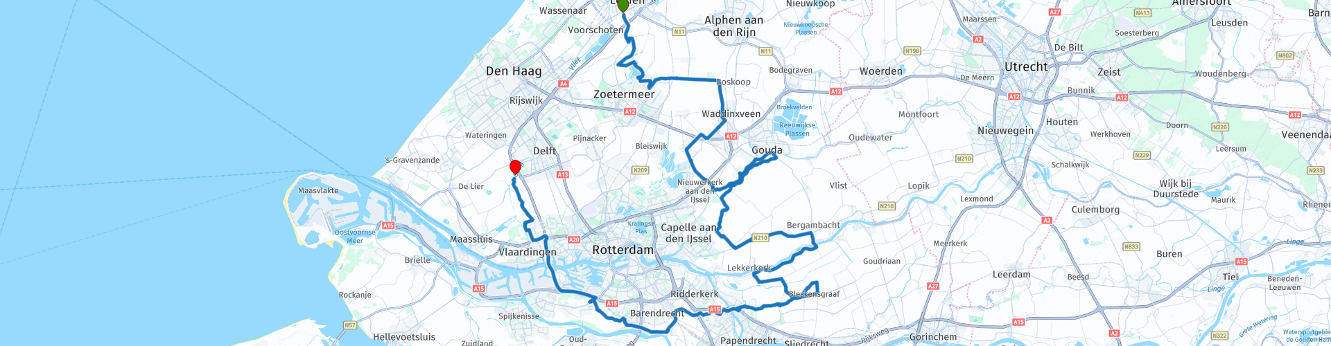
 * The Hollandse or Hollandsche IJssel is a river in the provinces of Utrecht and Zuid-Holland that follows a somewhat arc-shaped route between Nieuwegein and the Nieuwe Maas east of Rotterdam. (Source: Wikipedia).
After the break it continues towards Bergambacht where you cross the Lek ** to drive along the Lek to Nieuw Lekkerland.
** Lek is a Dutch river that from Wijk bij Duurstede is the continuation of the Lower Rhine and at Kinderdijk joins the North: as a New Maas, the river continues in a westerly direction. The length is 62 kilometers. (Source: Wikipedia).
Then you go to Bleskensgraaf where you get acquainted with the "Alblas" ***, you continue to follow this until you reach Alblasserdam.
*** The Alblas used to be a busy river with mainly barges transporting cattle feed (such as pulp). Farms from this period therefore have the front facing the water and not towards the road. This is because during the construction period, the river Alblas was a more important transport route than the road. Today, the river is only used by recreational vessels. (Source: Wikipedia).
In Alblasserdam you cross the Noord **** and you continue to follow the Waal ***** until Heerjansdam.
**** De Noord (formerly also known as Oude Merwede) is a tidal river in the Dutch province of South Holland between the east side of the island IJsselmonde and the west side of the Alblasserwaard. The Noord is a very busy shipping route that connects the river intersection with the Lower Merwede and the Oude Maas near Dordrecht with the north side of Ridderkerk, where the Lek and the Noord merge and form the Nieuwe Maas.
***** De Waal, popularly the Waaltje, is the name of a dead river arm through the island of IJsselmonde. The Waal has a length of 8 kilometers and runs from Hendrik-Ido-Ambacht via Oostendam and Rijsoord to Barendrecht and Heerjansdam where it is connected to the Oude Maas via a pumping station.
In Barendrecht you can stop at Oude Maasheuvel to view the artwork Sky, Moon, Mirror, Environment. Then you get a piece of highway A15 & A20 to drive to the endpoint in Schipluiden.
Because I have not (yet) driven this route myself, this route gets 3 stars.
Route details:
rp 20 - Lunch stop at "De Loet" in Lekkerkerk.
rp 38 - Viewpoint Gaatkensbult or Oude Maasheuvel


 Links
Links  Usage
Usage Want to download this route?
You can download the route for free without MyRoute-app account. To do so, open the route and click 'save as'. Want to edit this route?
No problem, start by opening the route. Follow the tutorial and create your personal MyRoute-app account. After registration, your trial starts automatically.  Disclaimer
Use of this GPS route is at your own expense and risk. The route has been carefully composed and checked by a MyRoute-app accredited RouteXpert for use on TomTom, Garmin and MyRoute-app Navigation.
Changes may nevertheless have occurred due to changed circumstances, road diversions or seasonal closures. We therefore recommend checking each route before use.
Preferably use the route track in your navigation system. More information about the use of MyRoute-app can be found on the website under 'Community' or 'Academy'.