TTT 2014 07 Joure Heeg

This route was brought to you by:
RouteXpert Hans van de Ven (Mr.MRA)
Last edit: 25-04-2021
 Route Summary
 The 173 ANWB Promoter TankTasTocht (TTT) were scanned by Henry ten Dam and signed by Leon Stolk in Mapsource and later placed as a Track in a .gpx file. These are made available through the MrGPS website with the approval of the ANWB Promoter so that everyone can enjoy them. The 1st TTT is from 1992, so the route may differ slightly from the original.
I have checked all route points and, where necessary, placed them neatly on the road. Also, if necessary, I have further spaced the start point and end point of the route to avoid navigating directly to the end point and I added the POI files from the start and end point just like a possible stopping point.
Finally, I made the route the same for TomTom, Garmin and MyRoute-app Navigation users.
Thanks to Henry, Leon, MrGPS and Promoter.
 Share this route


Animation

Verdict


Duration
3h 24m

Mode of travel
Car or motorcycle

Distance
132.53 km

Countries

 RouteXpert Review
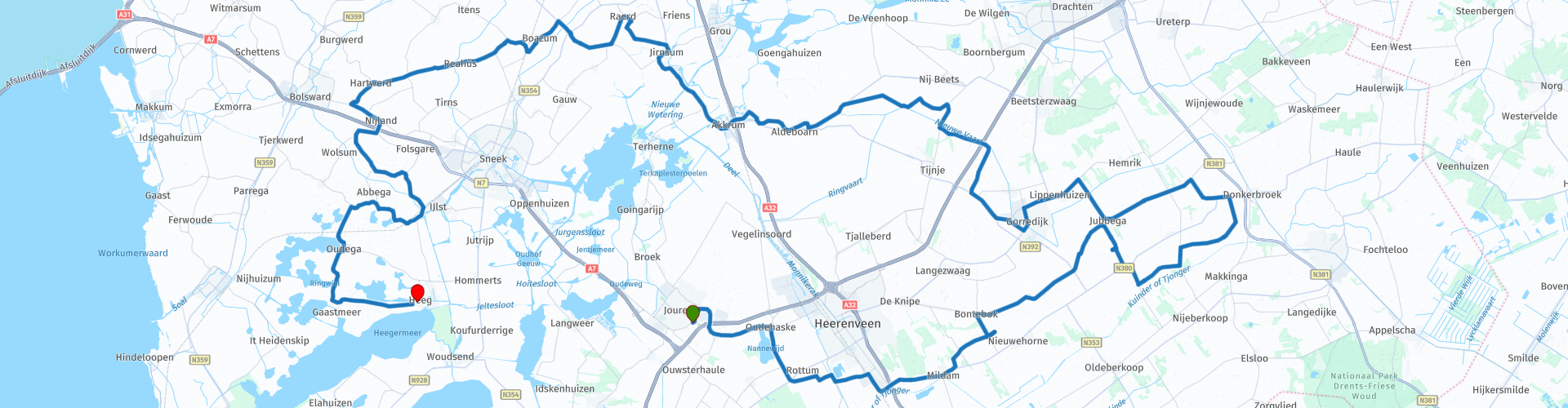
 This TTT through the Frisian landscape takes you past some municipalities that are also visited during the Eleven Cities Tour. You also regularly pass a canal or a canal in Friesland, in Gorredijk you can visit the Regional Museum Opsterland, Museum Opsterlân was originally a public primary school for which the foundation stone was laid on 1 September 1887. The design of the school is by architect Jacobus Anthonie Meessen, then municipal architect of the municipality of Opsterland. Until 1955 classes were given in the classrooms, but even today knowledge is still central. Knowledge about the history of Gorredijk and the municipality of Opsterland.
About halfway along the route, you can stop at Café Rolbrêge for coffee or lunch, this Café is located on De Nieuwe Vaart (Frisian and officially: Nije Feart) is a canal in the province of Friesland and borders the protected nature reserve the Van Oordt's Mersken , this lies in the lower course of the Boorne (or Koningsdiep) on the transition from sandy soils to peat bogs and on the transition from the lateral gradient of the stream valley. The site has a small-scale variety of various types of grassland and swamps. The area is especially important because of the present blue grasslands, and there are also Dotterbloemhooilanden and large sedge vegetation. The lowest part is an important goose landing place. Of some importance as a breeding ground for species of herb-rich grasslands (papa).
After the stop, we continue through the Frisian landscape and you will pass places like Akkrum, Jirnsum, Poppenwier, Pikesyl, Oudega and finally Heeg.
Because I have not (yet) driven this route myself, this route gets 3 stars.
Route details:
rp 21 - Opsterland regional museum
rp 22 - Tank option
rp 25 - Café Rolbrêge
rp 26 - Van Oordt's Mersken


 Links
Links  Usage
Usage Want to download this route?
You can download the route for free without MyRoute-app account. To do so, open the route and click 'save as'. Want to edit this route?
No problem, start by opening the route. Follow the tutorial and create your personal MyRoute-app account. After registration, your trial starts automatically.  Disclaimer
Use of this GPS route is at your own expense and risk. The route has been carefully composed and checked by a MyRoute-app accredited RouteXpert for use on TomTom, Garmin and MyRoute-app Navigation.
Changes may nevertheless have occurred due to changed circumstances, road diversions or seasonal closures. We therefore recommend checking each route before use.
Preferably use the route track in your navigation system. More information about the use of MyRoute-app can be found on the website under 'Community' or 'Academy'.