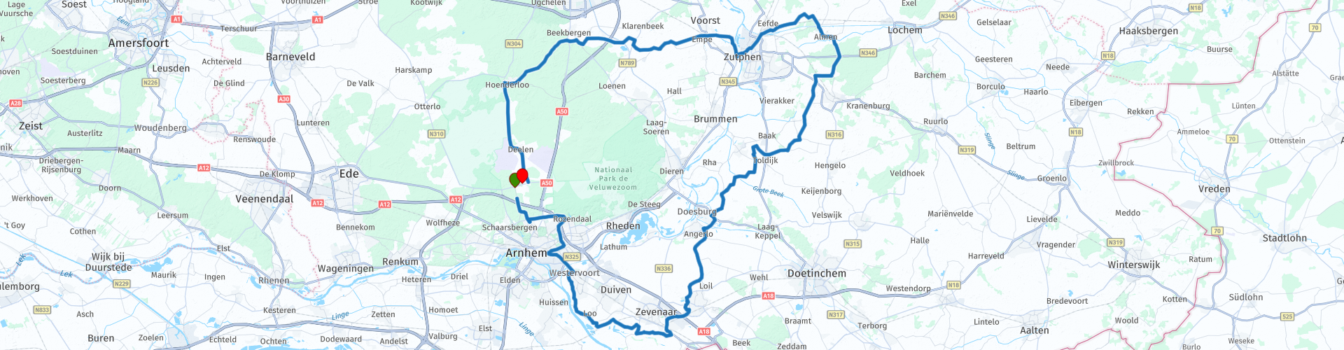
Rondrit Schaarsbergen Veluwezoom Zutphen

This route was brought to you by:
RouteXpert Dick Schaap
Last edit: 17-05-2023
 Route Summary
 Start and end route:
ECHOS The Landing
Share Road 28,
6816 TS Schaarsbergen
 Share this route


Animation

Verdict


Duration
4h 57m

Mode of travel
Car or motorcycle

Distance
126.68 km

Countries

 RouteXpert Review
 Shortly after the start, the route leaves the Deelerwoud and goes over the Cattepoelseweg towards the city of Arnhem. This road separates 2 of Arnhem's top attractions, Burgers Zoo on the right and the Arnhem Open Air Museum on the left.
In Arnhem, the route also passes the Museum Bronbeek. Bronbeek is a museum and the knowledge center of the colonial-military past of the Kingdom of the Netherlands. The Landgoed, the temporary exhibitions and café Batavia are freely accessible.
Although not visible from the route, the route after Arnhem follows the course of the NederRijn to Westervoort. This road, De Schans, runs over a kind of viaduct that has been dug into the soil. This is the Westervoort inlet lock. Built in 1950 and was part of the IJssellinie. After the lifting of the IJssellinie, the inlet sluice disappeared underground as part of the flood defence. In 1999, the inlet sluice was placed on the municipal monument list of the municipality of Westervoort. The IJssellinie was a military defense line that was built along the IJssel between 1951 and 1954 to protect the Netherlands against a land invasion from the east by means of inundation (= deliberately flooding an area).
After Westervoort it goes over dike roads (including the Ooysedijk) past Oud-Zevenaar to the De Nevelhorst recreation area, a nice place to take a break. It then goes through Gelderland polders and follows the old course of the Upper Rhine. Until 1707, here (on the right of the route) was the main course of the Rhine water to the North Sea. This area between Lobith and Pannerden, called Rhijnstrangen, is now a Natura 2000 area. Along the way, the route also passes the Karekiet nature reserve and the De Hoop windmill. De Hoop is a Stellingmolen from 1850. A Stellingmolen is a high windmill with a gallery or scaffolding, the circulation. Such a windmill is usually located in built-up areas and must be high in order to be able to catch sufficient wind within the built-up area, the free windage. The blades and tail therefore do not reach the ground. The mill is operated from this circuit. Think of the wheeling (turning to the wind) of the mill and putting the sails on the blades.
After the break, the route continues along Didam towards Doesburg with a crossing of the Oude IJssel. A little later the route passes the entrance of Museumtuin 't Olde Ras. This is a museum garden of the ANBI Foundation for the Preservation and Promotion of Fruit Culture. All types of fruit that have ever grown on Dutch soil have been planted here. More than 3000 trees in more than 1500 fruit varieties are in the museum garden. Fruit varieties such as apples, pears, cherries, plums, quinces, Japanese pears, medlars, ornamental fruit, berries, mulberries, nuts, almonds, peaches, apricots, wild plums, cherry plums, etc. Open for visits and courses.
Then in the municipality of Vorden, immediately after the Baakse Beek, on the left is the castle and estate Hackfort. A beautiful walking area. Hackfort Castle, built in 1392 by the lords of Bronckhorst as a residential tower with outer bailey and moats. Destroyed by Spanish troops in 1586, rebuilt in 1598 and 1788. Since 1981 owned by Natuurmonumenten by inheritance and legacy.
After Hackfort, east of Zutphen, the route goes towards Almen, where the Dorpsstraat is followed.
Museum Staal is located on the Dorpsstraat. In this museum you can experience the landscape, history and culture of the Achterhoek. Opposite Staal, on the left, is the Dorpskerk, built in the 14th century. Originally the Onze Lieve Vrouwekerk, but after the Reformation the Protestant Dorpskerk. A church with a special crypt. Between 1714 and 1835, the remains of a number of residents of “De Ehze” and “Het Hulze” were interred here. The coffins and corpses are well preserved (the Almense mummies). You can look inside through two barred windows. Next to the church is Hotel De Hoofdige Boer, a good lunch address.
After Almen the route goes north over the Twente Canal towards Zutphen. At Eefden, the Twente Canal is crossed again (Eefden Bridge) to take part of the city of Zutphen with it. Zutphen is left again via the old IJssel bridge and the route follows a small part of the IJssel before turning towards Voorst and Empe. Then through the beautiful green landscape of Gelderland towards Beekbergen. On the way we pass the hamlet of "Little Amsterdam", a hamlet of the municipality of Voorst.
After Beekbergen through the wooded areas of Liederbos, Spelderholt and Schenkenshul to Hoenderloo. In Hoenderloo, the route passes the Hoenderloo entrance to the Hoge Veluwe National Park and the Kröller Muller Museum. Entrance to the Hoge Veluwe park € 12.30, admission to the Kröller-Müller Museum € 12.50.
After this, the route goes over the Deelenseweg towards the end point "ECHOS De Landing", along the Deelensche field and Deelen airbase. At the airbase, the route passes the Deelen Air Base museum, immediately recognizable by the Starfighter F-104 Mockup parked along the road. The museum shows its collection from the history of the airbase. Ample attention is paid to the air war in the years 1940-1945. After this museum, the end point is ECHOS De Landing.


 Links
Links  Usage
Usage Want to download this route?
You can download the route for free without MyRoute-app account. To do so, open the route and click 'save as'. Want to edit this route?
No problem, start by opening the route. Follow the tutorial and create your personal MyRoute-app account. After registration, your trial starts automatically.  Disclaimer
Use of this GPS route is at your own expense and risk. The route has been carefully composed and checked by a MyRoute-app accredited RouteXpert for use on TomTom, Garmin and MyRoute-app Navigation.
Changes may nevertheless have occurred due to changed circumstances, road diversions or seasonal closures. We therefore recommend checking each route before use.
Preferably use the route track in your navigation system. More information about the use of MyRoute-app can be found on the website under 'Community' or 'Academy'.

Gelderland
About this region
Gelderland (Dutch: [ˈɣɛldərlɑnt] (listen)), also known as Guelders () in English, is a province of the Netherlands, occupying the centre-east of the country. With a total area of 5,136 km2 (1,983 sq mi) of which 173 km2 (67 sq mi) is water, it is the largest province of the Netherlands. Gelderland shares borders with six other provinces (Flevoland, Limburg, North Brabant, Overijssel, South Holland and Utrecht) and the German state of North Rhine-Westphalia.
The capital is Arnhem (pop. 159,265); however, Nijmegen (pop. 176,731) and Apeldoorn (pop. 162,445) are both larger municipalities. Other major regional centres in Gelderland are Ede, Doetinchem, Zutphen, Harderwijk, Tiel, Wageningen, Zevenaar, and Winterswijk. Gelderland had a population of 2,084,478 as of November 2019.
Read more on Wikipedia
The capital is Arnhem (pop. 159,265); however, Nijmegen (pop. 176,731) and Apeldoorn (pop. 162,445) are both larger municipalities. Other major regional centres in Gelderland are Ede, Doetinchem, Zutphen, Harderwijk, Tiel, Wageningen, Zevenaar, and Winterswijk. Gelderland had a population of 2,084,478 as of November 2019.
View region
 Statistics
  139
139Amount of RX reviews (Gelderland)
 62197
62197Amount of visitors (Gelderland)
 35804
35804Amount of downloads (Gelderland)
 Route Collections in this region
 The 10 most beautiful car and motorcycle routes in North Brabant
Brabant, Brabant conviviality, bon vivants and who does not know the song by Guus Meeuwis about Brabant? "And then I think of Brabant, because there is still light burning there" and that is true, because the City of Light is in Brabant, in Eindhoven that is, but Eindhoven is also known as the match city of the Netherlands. The annual light festival (GLOW) in Eindhoven shows breathtaking lighting techniques, something you must see once.
But not only light, matches and Brabant cosiness in Brabant, but also a very beautiful province to tour by car or motorcycle and enjoy all the beauty that the province of Brabant has to offer. For this, the MyRoute app RouteXpert has put together a Top 10 of Car and Motorcycle routes for you.
All routes in this collection have been checked and made equal for TomTom, Garmin and MyRoute-app Navigation by a MyRoute-app RouteXpert.
If you think, I have a very nice route that should certainly not be missing from this collection, send it to:
email: routeexpert@myrouteapp.com
Subject: New Route for the Top 10 collection Province of Brabant composed by Hans van de Ven.
The route will then be reviewed and then added to the Top 10.
To make the Top 10 also the Top 10, 1 route will have to disappear from the Top 10, you can indicate this when submitting the new route.
Have fun with this collection and while driving one of these routes. Enjoy all the beauty that the Netherlands and in particular the province of Brabant has to offer. Click on “View route” to read the review of the chosen route.
I would like to hear your findings about the route(s).
View Route Collection
The 10 most beautiful car and motorcycle routes in Limburg
Limburg, who thinks of Limburg, thinks of flan, coal mines, marl and the hill country. The coal mines have been closed for almost 40 years, the last load of coal was brought up from the Oranje-Nassau coal mine in Heerlen on 31 December and, as they say, South Limburg was transformed from Black to Green and unfortunately there is still little left. view of this period.
But not only pie, marl and coal in Limburg, but also a very beautiful province to tour by car or motorcycle and enjoy all the beauty that the province of Limburg has to offer. For this, the MyRoute app RouteXpert has put together a Top 10 of Car and Motorcycle routes for you.
All routes in this collection have been checked and made equal for TomTom, Garmin and MyRoute-app Navigation by a MyRoute-app RouteXpert.
If you think, I have a very nice route that should certainly not be missing from this collection, send it to:
email: routeexpert@myrouteapp.com
Subject: New Route for the Top 10 collection Province of Limburg composed by Hans van de Ven.
The route will then be reviewed and then added to the Top 10.
To make the Top 10 also the Top 10, 1 route will have to disappear from the Top 10, you can indicate this when submitting the new route.
Have fun with this collection and while driving one of these routes. Enjoy all the beauty that the Netherlands and in particular the province of Limburg has to offer. Click on “View route” to read the review of the chosen route.
I would like to hear your findings about the route(s).
View Route Collection