Lustrafjord Geirangerfjord Norddalsfjord Trollstigen Noorwegen

This route was brought to you by:
RouteXpert Michel van Hagen (MRA-Founder)
Last edit: 25-11-2019
 Route Summary
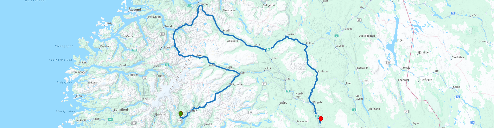
 ... And just to fall in with the door in the house, that is related both to the considerable abandonment and the unimaginable enjoyment! The day started drizzly, does not matter, because the road along the Lustrafjord is amazing, steel blue water, rugged mountains and empty roads with the occasional bend through. Beyond the Lustrafjord on the RV 55 begins an accumulation of hairpin bends where you spontaneously get drunk, drunk with happiness and without a hangover! The RV 55 meanders along the highest mountains in Norway with tops of 2500 meters. If you want to reach the roof of the Scandinavian road network, you have to take the exit to the Juvashytta at Galdesand. A dirt road meanders here to a height of 1850 meters. Unfortunately, I have not driven this road myself, another good reason to return!
While climbing the first hairpin bends, it became increasingly foggy, at one point I did not have more than 10 meters of visibility. The advantage was that I had this road almost entirely for myself. The RV 55 is perhaps the most beautiful road in Norway, and therefore automatically one of the most beautiful roads in Europe, it can be busy in high season. But in September and with this weather I may have seen 10 cars, a touring bus, a camper and 3 motorcyclists. Because of the fog I had to miss the view, which seems to be unreal beautiful. At 1400 meters altitude the temperature was around freezing, but due to a strong wind and icy rain it seemed arctic conditions. Being able to forgo so close and enjoy so being together! That is also, in my opinion, one of the great charms of traveling with the motor.
Around noon it started slowly to clear up, the abandonment became less and the big enjoyment got more and more space. In the town of Lom you turn left onto the RV 15 and although the RV 55 has the name to be one of the most beautiful roads in Norway, the RV 15 is not to be ignored. You drive for a long time along the Vista river to the intersection with the RV 63, you think you have seen a lot of beautiful things, the RV 63 takes it a step further! It starts quietly, but after an hour of sending there is a series of tight hairpin turns that you steeply hit back! Figuratively, of course, because we want to keep both wheels on the ground. After the hairpin bends again a beautiful piece of plateau comes and just before Geiranger you descend with tig hairpin bends to the Geiranger fjord. This fjord seems to be the most beautiful and most visited fjord in Norway, the best I can confirm, the most visited was as far as I am concerned, it was still very quiet on the road. If you have the time, book a hotel here, even in a country with so much natural beauty, the Geirangerfjord will stand out from above.
After the Geiranger fjord it is climbing again, and not too much! One hairpin bend is even tighter than the other, here I came across a tour bus and in the bend I really had to stop and move aside, because the tour bus needed the whole way to make the turn. At the top you come again, I decay in repetitions, on an unreal beautiful stretch of plateau. On the way you pass another foothill of the Geiranger fjord and you drive along the Valldøla river, I do not know how to put it, but I still remember how I felt: euphoric! Especially the last piece for Trollstigen is indescribably beautiful, but it has to be said, everything was with me. The weather was fantastic, a sun and between 10 and 16 degrees depending on how high, the roads were so empty that it looked like they had been dropped off especially for me. And then Trollstigen, a 20 km long wet dream for every motorcyclist. On top of the top is a viewing platform called Trollstigheim, from which there is a nice view of the road and the waterfalls such as Stigfossen. Trollstigen is closed during the winter months. Even in the spring (May-June) the road to the Trollstigen is sometimes closed for a few hours in the morning due to night frost.
I thought for a moment that even now the pass was closed, it was quiet, but I was passed by a roaring BMW and so the gas and the chase could be used. But soon I let go of the gas again to enjoy the fabulous view, I had to pinch myself to believe that this was real or a wet dream. During the descent you are musically accompanied by the thundering roar of the Stigfossen waterfall. The 11 hairpin bends are so tight that I needed a lot of top-heavy Africa Twin to get through it all. Certainly to know that coaches here a few times have to cross the bend to come, fortunately I came and say but 2 motorbikes, one camper and one van with German soldiers in that 20 km long descent. The German soldiers stopped in the same place as me, oh dear, I thought, if only that goes well, but they were very friendly and even offered to take pictures of me with my motorcycle! At the bottom of the motor you have to step down to keep the euphoric feeling a bit longer. Have the time, then turn around and take the 11 hairpin turns again from the bottom up and up again from top to bottom!
After Trollstigen you might think, what a deception, but nothing is less true. The first part on the E 136 and E 6 is indeed less spectacular, but turn right to the RV 29 and later the RV 27 you still get an unexpectedly beautiful piece of road for you. Say the dessert with whipped cream with all the trimmings of this day. If you arrive at the end of 13 hours of ultimate happiness, the abandonment at the beginning has already been forgotten, at your destination with a view of the Gudbrandsdalslågen Fjord, you can only stamina surprised and overwhelmed: "this was a day to remember "...
 Share this route


Animation

Verdict


Duration
9h 51m

Mode of travel
Car or motorcycle

Distance
556.86 km

Countries

 RouteXpert Review
 This is one of the most beautiful routes you can drive in Europe. I drove it as part of a 7 day Scandinavian trip, much too short ... Advice is not to drive this route in one day, but in 2 days. Then you have the time to reflect on the most beautiful things nature has to offer, but also to drive Trollstigen for example 3 times. First down, then up and then down again to continue your route. The route has been checked and created for TomTom, Garmin and MyRoute-app Navigation. The green waypoints are places where you really have to stop for a photo. This route is free and without the registration of MyRoute-app, click on the button 'Use route' and then 'Save as'. Do you want to edit the route? No problem, registering is also free and you can also choose to try the all-in-one subscription for free for 2 weeks!
Read here the entire travel story of the Scandinavia trip including the preparations: https://www.myrouteapp.com/en/social/blog/143?mode=share


 Usage
Usage Want to download this route?
You can download the route for free without MyRoute-app account. To do so, open the route and click 'save as'. Want to edit this route?
No problem, start by opening the route. Follow the tutorial and create your personal MyRoute-app account. After registration, your trial starts automatically.  Disclaimer
Use of this GPS route is at your own expense and risk. The route has been carefully composed and checked by a MyRoute-app accredited RouteXpert for use on TomTom, Garmin and MyRoute-app Navigation.
Changes may nevertheless have occurred due to changed circumstances, road diversions or seasonal closures. We therefore recommend checking each route before use.
Preferably use the route track in your navigation system. More information about the use of MyRoute-app can be found on the website under 'Community' or 'Academy'.

Hedmark
About this region
Hedmark ([ˈhêːdmɑrk] (listen)) was a county in Norway before 1 January 2020, bordering Trøndelag to the north, Oppland to the west, Akershus to the south, and Sweden to the east. The county administration is in Hamar.
Hedmark and Oppland counties were merged into Innlandet county on 1 January 2020, when Norway's former 19 counties became 10 bigger counties / regions
Hedmark made up the northeastern part of Østlandet, the southeastern part of the country. It had a long border with Sweden to the east (Dalarna County and Värmland County). The largest lakes were Femunden and Mjøsa, the largest lake in Norway. Parts of Glomma, Norway's longest river, flowed through Hedmark. Geographically,
Hedmark was traditionally divided into: Hedemarken (east of the lake Mjøsa), Østerdalen ("East Valley" north of the town Elverum), and Solør / Glåmdalen (south of Elverum) and Odal in the very south. Hedmark and Oppland were the only Norwegian counties with no coastline. Hedmark also hosted some events of the 1994 Winter Olympic Games.
Hamar, Kongsvinger, Elverum and Tynset were cities in the county. Hedmark was one of the less urbanized areas in Norway; about half of the inhabitants lived on rural land. The population was mainly concentrated in the rich agricultural district adjoining Mjøsa to the southeast. The county's extensive forests supplied much of Norway's timber; at one time, logs were floated down Glomma to the coast but are now transported by truck and train.
The Hedmark municipality of Engerdal had the distinction of marking the current southernmost border in Norway of Sápmi, the traditional region of the Sami people.
The county was divided into three traditional districts. Those were Hedmarken, Østerdalen and Solør (with Odalen and Vinger).
Hedmark was originally a part of the large Akershus amt, but in 1757 Oplandenes amt was separated from it. Some years later, in 1781, this was divided into Kristians amt (now Oppland) and Hedemarkens amt. Until 1919, the county was called Hedemarkens amt.
Read more on Wikipedia
Hedmark and Oppland counties were merged into Innlandet county on 1 January 2020, when Norway's former 19 counties became 10 bigger counties / regions
Hedmark made up the northeastern part of Østlandet, the southeastern part of the country. It had a long border with Sweden to the east (Dalarna County and Värmland County). The largest lakes were Femunden and Mjøsa, the largest lake in Norway. Parts of Glomma, Norway's longest river, flowed through Hedmark. Geographically,
Hedmark was traditionally divided into: Hedemarken (east of the lake Mjøsa), Østerdalen ("East Valley" north of the town Elverum), and Solør / Glåmdalen (south of Elverum) and Odal in the very south. Hedmark and Oppland were the only Norwegian counties with no coastline. Hedmark also hosted some events of the 1994 Winter Olympic Games.
Hamar, Kongsvinger, Elverum and Tynset were cities in the county. Hedmark was one of the less urbanized areas in Norway; about half of the inhabitants lived on rural land. The population was mainly concentrated in the rich agricultural district adjoining Mjøsa to the southeast. The county's extensive forests supplied much of Norway's timber; at one time, logs were floated down Glomma to the coast but are now transported by truck and train.
The Hedmark municipality of Engerdal had the distinction of marking the current southernmost border in Norway of Sápmi, the traditional region of the Sami people.
The county was divided into three traditional districts. Those were Hedmarken, Østerdalen and Solør (with Odalen and Vinger).
Hedmark was originally a part of the large Akershus amt, but in 1757 Oplandenes amt was separated from it. Some years later, in 1781, this was divided into Kristians amt (now Oppland) and Hedemarkens amt. Until 1919, the county was called Hedemarkens amt.
View region
 Statistics
  8
8Amount of RX reviews (Hedmark)
 24396
24396Amount of visitors (Hedmark)
 674
674Amount of downloads (Hedmark)
 Route Collections in this region
 Top Car and Motorcycle tour through Sweden and Norway
Sweden and Norway are beautiful countries. You will find nice cities, but also impressive nature reserves. This versatility makes Sweden & Norway the perfect countries for an impressive motorcycle holiday.
In this collection 14 beautiful routes through Sweden & Norway.
Good preparation is half the battle, so read the tips below carefully.
1. Check the weather forecast. It can be very hot in Sweden & Norway, but it can also get very cold. Always check the weather forecast before you go, so that you can pack the right clothes.
2. Decide in advance which route or routes you want to follow. This way you don't drive around like a headless chicken and you can make the most of your days off in these beautiful countries.
3. Familiarize yourself with the traffic rules. In Sweden & Norway, in some situations, slightly different rules apply than in the Netherlands. By immersing yourself in the traffic rules, you prevent (unknowingly) committing a traffic violation and/or putting yourself in a dangerous situation.
It is also wise to book the accommodations in advance. It might be more fun to drive through these countries on spec, but you don't want to drive around endlessly to find a place to sleep. If you go to Sweden or Norway during the high season, the chance that you will have to look for a place to sleep is greatest. It is also possible to camp during your motorcycle trip, but find out in advance where this is and is not allowed. You are not allowed to pitch your tent everywhere.
As the largest country in Scandinavia, you can enjoy extensive tours in a unique environment. Forests, lakes, nature parks and agricultural areas largely determine the landscape, which also consists of flat areas and rolling hills. Around the Swedish-Norwegian border is the Scandinavian Highlands, where the mountains rise locally to 2100 meters.
Norway is known for its amazing natural beauty. Fjords that go into the country tens of kilometers deep, snow-covered plateaus, sharp mountain peaks and vast forests. In this sparsely populated country, most people live in the cities, of which the capital Oslo is the largest.
Tolls have to be paid on a large number of roads in Norway. If you approach a toll road, you can continue without stopping. With cameras above the road, the license plate of the vehicle is scanned, not the registration number of the trailer or caravan. It takes quite some time to process the photos.
The bill is then sent home within four to six months by Euro Parking Collection (EPC) in London.
Mandatory on the motorcycle: Safety vest - A motorcyclist must bring at least one safety vest. In the event of a breakdown or accident, the driver is obliged to wear a safety vest. The ANWB advises motorcyclists to also bring a safety vest for a possible passenger.
Advice: First aid kit, motorcyclists are advised to bring a first aid kit.
View Route Collection
6500 kilometers through Scandinavia with the highlights of the Lofoten and the North Cape
The Arctic Challenge Tour, on which this 26-part tour is partly based, is not a speed race. It's a tour. It comes down to agility, good navigation and anticipation. The participants are obliged to adhere to the speed limit of the country concerned. The participants must find the ideal route with the shortest possible distance by complying 100% with the locally applicable traffic rules. Of course, also take maximum speeds into account. The organization checks for violations of the speed limit. In case of gross or repeated exceeding of the maximum speed, disqualification for the relevant stage and for the final classification will follow. Control of the route and speeds is done by means of a track and trace system. This equipment is installed in every vehicle. You can then follow each team accurately in the Back Office. Those staying at home, interested parties and participants can also see the performances of the teams, because you can be followed live via the Internet. The Back Office takes action when a team gets into trouble. (source: website The Arctic Challenge)
That's quite a luxury, having a back office behind you that keeps an eye on you. Most of us will not have that and are on our own or the fellow traveler(s). The only agreement you have with the participants is that you also have to abide by the rules. Fortunately, you don't have to complete this tour in 9 days, like the participants, but you can take it a little longer.
The highlight of the Arctic Challenge in 2020 was the Lofoten, an island group northwest of Norway. The Lofoten archipelago is located in the middle of the wild Norwegian Sea, well above the Arctic Circle. This special region offers a beautiful landscape with imposing mountains, deep fjords and long, wild sandy beaches where the sound of the seabird colonies can always be heard.
The archipelago is best known for its rich fishing tradition. The Lofoten makes a prosperous impression despite their isolated location. The entire economy revolves above all around fishing. The image of the Lofoten is mainly dominated by wooden racks with cod, which hangs to dry. Lofoten fishing has been a household name for centuries. In the middle of winter, the ships set out to catch the fish in just a few months. The rich fishing grounds are due to the North Atlantic Warm Gulf Stream around the islands, in which the fish have their spawning grounds. Oil drilling is not permitted around Lofoten and the cod spawning grounds there.
The next destination for the participants was Sirkka, also known as Levi, a winter sports resort in Finnish Lapland. They stayed there for a few days to go ice-karting and to enjoy the snow by going on a snowmobile or skiing trip. This tour also takes you to Sirkka, but instead of staying there for a few days, you have the option to continue to the North Cape, the second highlight of this trip.
Imagine a place in the far north, where the Atlantic Ocean meets the icy waters of the Arctic Ocean. This place is the North Cape in Western Finnmark in Northern Norway. From here, only the archipelago of Spitsbergen lies between you and the North Pole and the sun shines for 2.5 months at a time; from mid-May to the end of July. Many visitors admire the midnight sun or the sunset over the Barents Sea from the North Cape plateau.
With each route you will find a review with a description of the route, where you pass and what to see along the way. It is also briefly described how the participants in the Arctic Challenge in 2020 had to drive it anyway, from which point to which point. Along the way, markings (route points) have been included that indicate the end points of the stages that the participants had to complete. As mentioned, they covered the distance in 9 days, stages of more than 1000 kilometers were no exception.
Each route ends at a hotel. It is of course not an obligation to use these hotels, you can always find another place to stay in the area, that decision is up to you. My experience, however, is that they are all simple but good hotels for a very reasonable price. They are known and can be booked at booking.com.
The routes of these collections:
R01 - Puttgarden to Angelholm, 280km
R02 - Angelholm to Alingsas, 281km
R03 - Alingsas to Mysen, 261km
R04 - Mysen to Rena, 312km
R05 - Rena to Orkanger, 306km
R06 - Orkanger to Grong, 292km
R07 - Grong to Mo i Rana, 290km
R08 - Mo i Rana to Bodo, 231km
R09 - Roundtour Bodo to Lofoten part 1, 314km
R10 - Roundtour Bodo to Lofoten part 2, 250km
R11 - Roundtour Bodo to Lofoten part 3, 291km
R12 - Bodo to Arjeplog, 295km
R13 - Arjeplog to Jokkmokk, 244km
R14 - Jokkmokk to Pajala, 239km
R15 - Roundtour Sirkka to North Cape part 1, 257km
R16 - Roundtour Sirkka to North Cape part 2, 300km
R17 - Roundtour Sirkka to North Cape part 3, 244km
R18 - Roundtour Sirkka to North Cape part 4, 275km
R19 - Roundtour Sirkka to North Cape part 5, 332km
R20 - Sirkka to Kemi, 299km
R21 - Kemi to Ylivieska, 251km
R22 - Ylivieska to Jalasjarvi, 236km
R23 - Jalasjarvi to Turku, 279km
R24 - Stockholm to Askersund, 271km
R25 - Askersund to Varnamo, 224
R26 - Varnamo to Trelleborg, 259km
Have fun driving these routes!
View Route Collection