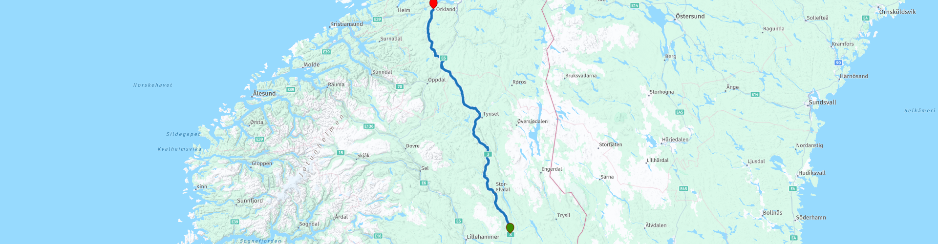
R05 Rena to Orkanger

This route was brought to you by:
RouteXpert Arno van Lochem - Senior RX
Last edit: 27-02-2021
 Route Summary
 The routes are easy for everyone to ride and are on well-paved roads. There may be a single hairpin bend to be taken, but these are fine.
If there is a piece of gravel in the route, a warning will be given and a detour will be indicated.
In this part of the tour you drive along the Glomma, Norway's longest river. You see endless forests and beautiful valleys, such as the Orkladal passing by. In that valley you can see in a museum how it used to be here. You will also pass the Orkla Industrial Museum where you can learn something about trains and mining.
The final destination is a hotel, but the camper has also been thought of, there are a number of campsites indicated where you can rent a hiker's cabin or camp.
Beautiful scenery, excellent roads and nice sights, hence the rating of 4 stars.
 Share this route


Animation

Verdict


Duration
7h 34m

Mode of travel
Car or motorcycle

Distance
306.06 km

Countries

 RouteXpert Review
 Of all western European countries, the Scandinavian countries probably have the most more or less untouched nature. In addition, they are countries that are easily accessible from the Netherlands. Norway is characterized by, among other things, the fjords and the Trollstigen known to many motorcyclists. And where Sweden is known as wide and relaxing, everyone knows Finland as the land of 1000 lakes. All in all, legitimate reasons to traverse this beautiful nature in the north of Europe by means of a number of routes.
The route starts in Rena, a small town located in central Norway. You start directly on National Road 3, a medium road that will take you further north. You drive directly along the Glomma, with a length of 621 kilometers the longest river in Norway. The catchment area of this river covers 13% of Norway, all in the southern part of the country.
The route then runs on the left bank, then again on the right bank. Every now and then a trip to the other side to just pass an attraction. In some places the road is much higher than the river, so if you can see the river, you have a beautiful view. This is the case, for example, with Garbekkegga. If you stop here and walk to the east you have a great view over the Glomma. Perfect place for a photo!
A few miles away, you'll spot a giant shiny moose, The Big Elk, also known as Storelgen (meaning 'big moose' in Norwegian), is the world's second tallest moose sculpture. The statue is an attempt to reduce traffic accidents by encouraging drivers to take a break and be aware of wildlife on the roads. The statue has a height of 10.3 meters, is made of polished stainless steel and cost a whopping € 200,000. All in all, well worth stopping and taking a look, if only to see if your hair is still in place.
After all this glitter, it's time for a cup of coffee. The first stop is planned at Glopheim Kafe. The cafe is decorated in true 1950s style - and stands out as the most authentic 1950s cafe in Norway. Here you will find a jukebox, black and white TV and a pinball machine, as well as items from the 50s. Great to enjoy a cup of coffee here in Happy Days style. Recommended!
The route meanders further along the Glomma, you now drive a bit on the east bank of the river. You will pass Jutulhogget Canyon, a place where you just have to take a look. That is, if you have no problems with gravel roads. To get there you have to drive about 500 meters on gravel. And back again of course, so a total of 1 kilometer. Your visit will be rewarded with the view over a beautiful piece of nature. The largest canyon in Northern Europe, which was formed during the last Ice Age about 10,000 years ago. You can experience the Jutulhogget Canyon on foot by descending the steep trail, or you can enjoy the view from the rim.
In Alvdal it is time for lunch, you can choose from a number of restaurants, there is bound to be something to your liking. Close to the restaurants, you'll also come across Aukrustsenteret, a museum built to house the life's work of multi-artist Kjell Aukrust. Visit this beautiful building and experience Aukrust's drawings, paintings, figures and humorous imaginative invention.
After lunch you drive further north and after about 25 kilometers the route bends off the Glomma, you will not see it again today. A few dozen kilometers further, however, you drive along another river, the Orkla. This river is shorter than the Glomma, but at 180 kilometers it is the longest in the province of Trøndelag. It flows through the Orkla valley and eventually flows into the Orkdslsfjorden, close to Orkanger.
In the last 30 kilometers of the route you will pass two museums. The first is the Orkla Industrimuseum. If you like technology you should take a look here. The museum has the oldest AC-powered railway still in operation, the Thamshavn railway. They still run with carriages that were delivered at the opening of the railway in 1908. You can also visit an old mine. So dress up as a miner, including helmet with lamp, and go down!
More than 5 kilometers further you will find the exit to Orkdal Bygdetun. This museum offers you a walk through the rural history of the Ork Valley. Nice to see. The road to it is made of gravel and has a length of approximately 6 kilometers one way.
The route ends at Hotel Vertshuset Fannarheimr in Orkland. A simple and inexpensive hotel, equipped with a bar and a restaurant. In the evening, the route can therefore be evaluated again while enjoying a drink.
Three campsites are indicated for campers in the vicinity of the end point: Kvåles Kro og Ridesenter, Follo Camping and Orkla Gjestegård
Have fun driving this route!


 Links
Links  Usage
Usage Want to download this route?
You can download the route for free without MyRoute-app account. To do so, open the route and click 'save as'. Want to edit this route?
No problem, start by opening the route. Follow the tutorial and create your personal MyRoute-app account. After registration, your trial starts automatically.  Disclaimer
Use of this GPS route is at your own expense and risk. The route has been carefully composed and checked by a MyRoute-app accredited RouteXpert for use on TomTom, Garmin and MyRoute-app Navigation.
Changes may nevertheless have occurred due to changed circumstances, road diversions or seasonal closures. We therefore recommend checking each route before use.
Preferably use the route track in your navigation system. More information about the use of MyRoute-app can be found on the website under 'Community' or 'Academy'.

Hedmark
About this region
Hedmark ([ˈhêːdmɑrk] (listen)) was a county in Norway before 1 January 2020, bordering Trøndelag to the north, Oppland to the west, Akershus to the south, and Sweden to the east. The county administration is in Hamar.
Hedmark and Oppland counties were merged into Innlandet county on 1 January 2020, when Norway's former 19 counties became 10 bigger counties / regions
Hedmark made up the northeastern part of Østlandet, the southeastern part of the country. It had a long border with Sweden to the east (Dalarna County and Värmland County). The largest lakes were Femunden and Mjøsa, the largest lake in Norway. Parts of Glomma, Norway's longest river, flowed through Hedmark. Geographically,
Hedmark was traditionally divided into: Hedemarken (east of the lake Mjøsa), Østerdalen ("East Valley" north of the town Elverum), and Solør / Glåmdalen (south of Elverum) and Odal in the very south. Hedmark and Oppland were the only Norwegian counties with no coastline. Hedmark also hosted some events of the 1994 Winter Olympic Games.
Hamar, Kongsvinger, Elverum and Tynset were cities in the county. Hedmark was one of the less urbanized areas in Norway; about half of the inhabitants lived on rural land. The population was mainly concentrated in the rich agricultural district adjoining Mjøsa to the southeast. The county's extensive forests supplied much of Norway's timber; at one time, logs were floated down Glomma to the coast but are now transported by truck and train.
The Hedmark municipality of Engerdal had the distinction of marking the current southernmost border in Norway of Sápmi, the traditional region of the Sami people.
The county was divided into three traditional districts. Those were Hedmarken, Østerdalen and Solør (with Odalen and Vinger).
Hedmark was originally a part of the large Akershus amt, but in 1757 Oplandenes amt was separated from it. Some years later, in 1781, this was divided into Kristians amt (now Oppland) and Hedemarkens amt. Until 1919, the county was called Hedemarkens amt.
Read more on Wikipedia
Hedmark and Oppland counties were merged into Innlandet county on 1 January 2020, when Norway's former 19 counties became 10 bigger counties / regions
Hedmark made up the northeastern part of Østlandet, the southeastern part of the country. It had a long border with Sweden to the east (Dalarna County and Värmland County). The largest lakes were Femunden and Mjøsa, the largest lake in Norway. Parts of Glomma, Norway's longest river, flowed through Hedmark. Geographically,
Hedmark was traditionally divided into: Hedemarken (east of the lake Mjøsa), Østerdalen ("East Valley" north of the town Elverum), and Solør / Glåmdalen (south of Elverum) and Odal in the very south. Hedmark and Oppland were the only Norwegian counties with no coastline. Hedmark also hosted some events of the 1994 Winter Olympic Games.
Hamar, Kongsvinger, Elverum and Tynset were cities in the county. Hedmark was one of the less urbanized areas in Norway; about half of the inhabitants lived on rural land. The population was mainly concentrated in the rich agricultural district adjoining Mjøsa to the southeast. The county's extensive forests supplied much of Norway's timber; at one time, logs were floated down Glomma to the coast but are now transported by truck and train.
The Hedmark municipality of Engerdal had the distinction of marking the current southernmost border in Norway of Sápmi, the traditional region of the Sami people.
The county was divided into three traditional districts. Those were Hedmarken, Østerdalen and Solør (with Odalen and Vinger).
Hedmark was originally a part of the large Akershus amt, but in 1757 Oplandenes amt was separated from it. Some years later, in 1781, this was divided into Kristians amt (now Oppland) and Hedemarkens amt. Until 1919, the county was called Hedemarkens amt.
View region
 Statistics
  8
8Amount of RX reviews (Hedmark)
 24120
24120Amount of visitors (Hedmark)
 665
665Amount of downloads (Hedmark)
 Route Collections in this region
 Top Car and Motorcycle tour through Sweden and Norway
Sweden and Norway are beautiful countries. You will find nice cities, but also impressive nature reserves. This versatility makes Sweden & Norway the perfect countries for an impressive motorcycle holiday.
In this collection 14 beautiful routes through Sweden & Norway.
Good preparation is half the battle, so read the tips below carefully.
1. Check the weather forecast. It can be very hot in Sweden & Norway, but it can also get very cold. Always check the weather forecast before you go, so that you can pack the right clothes.
2. Decide in advance which route or routes you want to follow. This way you don't drive around like a headless chicken and you can make the most of your days off in these beautiful countries.
3. Familiarize yourself with the traffic rules. In Sweden & Norway, in some situations, slightly different rules apply than in the Netherlands. By immersing yourself in the traffic rules, you prevent (unknowingly) committing a traffic violation and/or putting yourself in a dangerous situation.
It is also wise to book the accommodations in advance. It might be more fun to drive through these countries on spec, but you don't want to drive around endlessly to find a place to sleep. If you go to Sweden or Norway during the high season, the chance that you will have to look for a place to sleep is greatest. It is also possible to camp during your motorcycle trip, but find out in advance where this is and is not allowed. You are not allowed to pitch your tent everywhere.
As the largest country in Scandinavia, you can enjoy extensive tours in a unique environment. Forests, lakes, nature parks and agricultural areas largely determine the landscape, which also consists of flat areas and rolling hills. Around the Swedish-Norwegian border is the Scandinavian Highlands, where the mountains rise locally to 2100 meters.
Norway is known for its amazing natural beauty. Fjords that go into the country tens of kilometers deep, snow-covered plateaus, sharp mountain peaks and vast forests. In this sparsely populated country, most people live in the cities, of which the capital Oslo is the largest.
Tolls have to be paid on a large number of roads in Norway. If you approach a toll road, you can continue without stopping. With cameras above the road, the license plate of the vehicle is scanned, not the registration number of the trailer or caravan. It takes quite some time to process the photos.
The bill is then sent home within four to six months by Euro Parking Collection (EPC) in London.
Mandatory on the motorcycle: Safety vest - A motorcyclist must bring at least one safety vest. In the event of a breakdown or accident, the driver is obliged to wear a safety vest. The ANWB advises motorcyclists to also bring a safety vest for a possible passenger.
Advice: First aid kit, motorcyclists are advised to bring a first aid kit.
View Route Collection
6500 kilometers through Scandinavia with the highlights of the Lofoten and the North Cape
The Arctic Challenge Tour, on which this 26-part tour is partly based, is not a speed race. It's a tour. It comes down to agility, good navigation and anticipation. The participants are obliged to adhere to the speed limit of the country concerned. The participants must find the ideal route with the shortest possible distance by complying 100% with the locally applicable traffic rules. Of course, also take maximum speeds into account. The organization checks for violations of the speed limit. In case of gross or repeated exceeding of the maximum speed, disqualification for the relevant stage and for the final classification will follow. Control of the route and speeds is done by means of a track and trace system. This equipment is installed in every vehicle. You can then follow each team accurately in the Back Office. Those staying at home, interested parties and participants can also see the performances of the teams, because you can be followed live via the Internet. The Back Office takes action when a team gets into trouble. (source: website The Arctic Challenge)
That's quite a luxury, having a back office behind you that keeps an eye on you. Most of us will not have that and are on our own or the fellow traveler(s). The only agreement you have with the participants is that you also have to abide by the rules. Fortunately, you don't have to complete this tour in 9 days, like the participants, but you can take it a little longer.
The highlight of the Arctic Challenge in 2020 was the Lofoten, an island group northwest of Norway. The Lofoten archipelago is located in the middle of the wild Norwegian Sea, well above the Arctic Circle. This special region offers a beautiful landscape with imposing mountains, deep fjords and long, wild sandy beaches where the sound of the seabird colonies can always be heard.
The archipelago is best known for its rich fishing tradition. The Lofoten makes a prosperous impression despite their isolated location. The entire economy revolves above all around fishing. The image of the Lofoten is mainly dominated by wooden racks with cod, which hangs to dry. Lofoten fishing has been a household name for centuries. In the middle of winter, the ships set out to catch the fish in just a few months. The rich fishing grounds are due to the North Atlantic Warm Gulf Stream around the islands, in which the fish have their spawning grounds. Oil drilling is not permitted around Lofoten and the cod spawning grounds there.
The next destination for the participants was Sirkka, also known as Levi, a winter sports resort in Finnish Lapland. They stayed there for a few days to go ice-karting and to enjoy the snow by going on a snowmobile or skiing trip. This tour also takes you to Sirkka, but instead of staying there for a few days, you have the option to continue to the North Cape, the second highlight of this trip.
Imagine a place in the far north, where the Atlantic Ocean meets the icy waters of the Arctic Ocean. This place is the North Cape in Western Finnmark in Northern Norway. From here, only the archipelago of Spitsbergen lies between you and the North Pole and the sun shines for 2.5 months at a time; from mid-May to the end of July. Many visitors admire the midnight sun or the sunset over the Barents Sea from the North Cape plateau.
With each route you will find a review with a description of the route, where you pass and what to see along the way. It is also briefly described how the participants in the Arctic Challenge in 2020 had to drive it anyway, from which point to which point. Along the way, markings (route points) have been included that indicate the end points of the stages that the participants had to complete. As mentioned, they covered the distance in 9 days, stages of more than 1000 kilometers were no exception.
Each route ends at a hotel. It is of course not an obligation to use these hotels, you can always find another place to stay in the area, that decision is up to you. My experience, however, is that they are all simple but good hotels for a very reasonable price. They are known and can be booked at booking.com.
The routes of these collections:
R01 - Puttgarden to Angelholm, 280km
R02 - Angelholm to Alingsas, 281km
R03 - Alingsas to Mysen, 261km
R04 - Mysen to Rena, 312km
R05 - Rena to Orkanger, 306km
R06 - Orkanger to Grong, 292km
R07 - Grong to Mo i Rana, 290km
R08 - Mo i Rana to Bodo, 231km
R09 - Roundtour Bodo to Lofoten part 1, 314km
R10 - Roundtour Bodo to Lofoten part 2, 250km
R11 - Roundtour Bodo to Lofoten part 3, 291km
R12 - Bodo to Arjeplog, 295km
R13 - Arjeplog to Jokkmokk, 244km
R14 - Jokkmokk to Pajala, 239km
R15 - Roundtour Sirkka to North Cape part 1, 257km
R16 - Roundtour Sirkka to North Cape part 2, 300km
R17 - Roundtour Sirkka to North Cape part 3, 244km
R18 - Roundtour Sirkka to North Cape part 4, 275km
R19 - Roundtour Sirkka to North Cape part 5, 332km
R20 - Sirkka to Kemi, 299km
R21 - Kemi to Ylivieska, 251km
R22 - Ylivieska to Jalasjarvi, 236km
R23 - Jalasjarvi to Turku, 279km
R24 - Stockholm to Askersund, 271km
R25 - Askersund to Varnamo, 224
R26 - Varnamo to Trelleborg, 259km
Have fun driving these routes!
View Route Collection