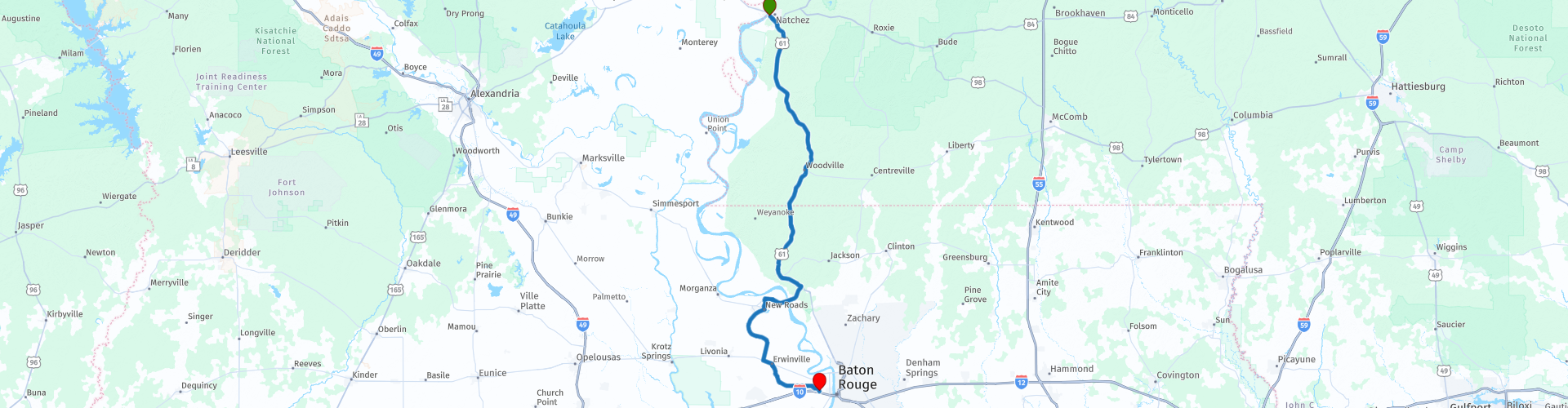
D07 Natchez Port Allen Baton Rouge

This route was brought to you by:
RouteXpert Hans van de Ven (Mr.MRA)
Last edit: 17-11-2019
 Route Summary
 The roads are good and the views are beautiful, certainly a route where you will stop several times along the way.
Starting point: Hotel Vue, Natchez.
End point: Best Western Magnolia Manor
The route has been made the same for TomTom, Garmin and MyRoute-app Navigation users.
Thanks to Richard & Lisa for the information!
 Share this route


Animation

Verdict


Duration
2h 10m

Mode of travel
Car or motorcycle

Distance
170.68 km

Countries

 RouteXpert Review
 Directly on the majestic Mississippi River is Baton Rouge (literally 'red stick'), the capital of Louisiana. Years of French, Spanish and British rule have ensured that a special mix of cultures has emerged. The Cajun culture is the most characteristic of this. The former plantation life has also left its mark on the city. Along the Mississippi you will find several old plantations, with the Myrtles Plantation as the best known example. Baton Rouge is seen as one of the best 'Foodie Cities' in the South.
You could also visit the USS Kidd Veterans Memorial and Museum or Old Louisiana State Capitol or the Louisiana State Museum, plenty of choice to spend the day useful.
In this 4-star route you drive on beautiful good roads, a trip with a propeller boat is a must.
History:
Baton Rouge is located on an earlier border between habitats of the Bayougoulas and Houmas Indian. The trunks marked the border with cypress trees and wooden posts with blood, fish heads and animals on top. The name Baton Rouge dates from 1699, when the French explorer Pierre Le Moyne led an expedition along the Mississippi. At one point he saw such a red piece of wood. The explorers called the wooden marking and therefore the location "le bâton rouge", which means "red stick" in French.
Baton Rouge has had to deal with various administrators over the centuries. Successively the area is ruled by France (1699-1763), Great Britain (1763-1779), Spain (1779-1810), the Republic of West Florida (1810-1812), the Union (1812-1861), the Confederate States (during the American Civil War, 1861-1865) and finally the United States.
In 1755, many Frenchmen sought refuge in the Louisiana countryside after being driven from Canada by British troops. This group of people, also known as Cajuns, enriched the Baton Rouge area with their culture. In 1849, Baton Rouge was named the capital of Louisiana. During the first half of the nineteenth century, the city grew steadily through trade and transport via the steamboat. The American Civil War caused the economic process in Baton Rouge to stop. In 1862 the northern troops of the Union took Baton Rouge. After the Civil War, Baton Rouge became the capital of Louisiana again.


 Links
Links  Usage
Usage Want to download this route?
You can download the route for free without MyRoute-app account. To do so, open the route and click 'save as'. Want to edit this route?
No problem, start by opening the route. Follow the tutorial and create your personal MyRoute-app account. After registration, your trial starts automatically.  Disclaimer
Use of this GPS route is at your own expense and risk. The route has been carefully composed and checked by a MyRoute-app accredited RouteXpert for use on TomTom, Garmin and MyRoute-app Navigation.
Changes may nevertheless have occurred due to changed circumstances, road diversions or seasonal closures. We therefore recommend checking each route before use.
Preferably use the route track in your navigation system. More information about the use of MyRoute-app can be found on the website under 'Community' or 'Academy'.

Mississippi
About this region
Mississippi is a state in the Southeastern region of the United States, bordered to the north by Tennessee; to the east by Alabama; to the south by the Gulf of Mexico; to the southwest by Louisiana; and to the northwest by Arkansas. Mississippi's western boundary is largely defined by the Mississippi River. Mississippi is the 32nd largest and 34th-most populous of the 50 U.S. states. Jackson is both the state's capital and largest city. Greater Jackson is the state's most populous metropolitan area, with an estimated population of 580,166 in 2018.
On December 10, 1817, Mississippi became the 20th state admitted to the Union. By 1860, Mississippi was the nation's top cotton-producing state and slaves accounted for 55% of the state population. Mississippi declared its secession from the Union on January 9, 1861, and was one of the seven original Confederate States, which constituted the largest slaveholding states in the nation. Following the Civil War, it was restored to the Union on February 23, 1870.Until the Great Migration of the 1930s, African Americans were a majority of Mississippi's population. In 2010, 37.3% of Mississippi's population was African American, the highest percentage of any state. Mississippi was the site of many prominent events during the civil rights movement, including the Ole Miss riot of 1962 by white students objecting to desegregation, the 1963 assassination of Medgar Evers, and the 1964 Freedom Summer murders of three activists working on voting rights.
Mississippi is almost entirely within the Gulf coastal plain, and generally consists of lowland plains and low hills. The northwest remainder of the state consists of the Mississippi Delta, a section of the Mississippi Alluvial Plain. Mississippi's highest point is Woodall Mountain at 807 feet (246 m) above sea level adjacent to the Cumberland Plateau; the lowest is the Gulf of Mexico. Mississippi has a humid subtropical climate classification.
Mississippi frequently ranks low among U.S. states in measures of health, education, and development, while ranking high in measures of poverty. The adage "Thank God for Mississippi" became popular due to these rankings and is often said by natives of other low-ranking U.S. states, as Mississippi's extremely low ranking usually spares those states from the shame of coming in last place.
Read more on Wikipedia
On December 10, 1817, Mississippi became the 20th state admitted to the Union. By 1860, Mississippi was the nation's top cotton-producing state and slaves accounted for 55% of the state population. Mississippi declared its secession from the Union on January 9, 1861, and was one of the seven original Confederate States, which constituted the largest slaveholding states in the nation. Following the Civil War, it was restored to the Union on February 23, 1870.Until the Great Migration of the 1930s, African Americans were a majority of Mississippi's population. In 2010, 37.3% of Mississippi's population was African American, the highest percentage of any state. Mississippi was the site of many prominent events during the civil rights movement, including the Ole Miss riot of 1962 by white students objecting to desegregation, the 1963 assassination of Medgar Evers, and the 1964 Freedom Summer murders of three activists working on voting rights.
Mississippi is almost entirely within the Gulf coastal plain, and generally consists of lowland plains and low hills. The northwest remainder of the state consists of the Mississippi Delta, a section of the Mississippi Alluvial Plain. Mississippi's highest point is Woodall Mountain at 807 feet (246 m) above sea level adjacent to the Cumberland Plateau; the lowest is the Gulf of Mexico. Mississippi has a humid subtropical climate classification.
Mississippi frequently ranks low among U.S. states in measures of health, education, and development, while ranking high in measures of poverty. The adage "Thank God for Mississippi" became popular due to these rankings and is often said by natives of other low-ranking U.S. states, as Mississippi's extremely low ranking usually spares those states from the shame of coming in last place.
View region
 Statistics
  13
13Amount of RX reviews (Mississippi)
 8831
8831Amount of visitors (Mississippi)
 308
308Amount of downloads (Mississippi)
 Route Collections in this region
 Top car and motorcycle tour through the Deep South of the USA
By car or motorcycle through the deep south of America is a journey that you do not just make, so also not driving 12 days and then back home. No, book a stay of several days in Pigeon Forge, Nashville, Memphis, Natchez and New Orleans and again Pigeon Forge to also visit several places of interest in these cities, so that this tour becomes an unforgettable tour that you can remember with pleasure.
Do not forget to arrange and pack the following items:
*This is only a summary and completely personal and may differ per person.
Take out travel insurance, +31 for numbers in GSM, (partially) take out gas, Health insurance coverage at destination?, Switch off electrical appliances, Lighting (time clock), Check passport validity, Antenna from radio/TV due to lightning, Residence address for those left behind, Remote control house alarm, Book Smart Parking.
Hand luggage:
Liquids in packaging of max. 100 ml, Liquids in hand luggage in transparent plastic bag.
For on the road:
Candy, Book, Earplugs, Country and road map(s), Directions, Maps in your navigation system
Money & Securities:
Bank card / giro card, Credit card (think pin code), Cash, Calculator for Internet banking, Medical insurance card, Travel insurance card.
Travel documents:
Passport, (International) Driver's License, Ticket(s), Reservation Tickets, Hotel Vouchers, Arrival/Departure Time, Check-in & Check-out Times, Valid Visa (ESTA), Travel Guide.
Clothing:
Underwear, Belt, Shirts/ T-shirts, Shorts, Long pants, Shoes, Socks, Swim trunks, Towel, Slippers.
Personal stuff:
Watch, House Keys, Wallet, Sunglasses.
Toiletries:
Deodorant, Shower gel / Soap, Comb / brush, Shaving equipment, Shampoo, Toothbrush, Toothpaste, Sanitary pads
Health & Medicine:
Own medicines, Insect repellent, Cold sore ointment, Ointment for insect bites, Sunscreen, Norit, Paracetamol, Suction cup for insect bites, First aid bag.
Miscellaneous:
Travel bag / waist bag, Leatherman (= checked luggage), Pen or pencil, Headlamp, Lighter, Tools & Electronics, Mobile phone & charger, Photo/video camera & charger, Memory card(s), World plug / adapter, Ipod & charger, Adapter cable Ipod, Headphones, iPad & charger, Navigation & charger/plug, Plug socket, Fuelpack battery.
Engine (accessories):
Helmet, Motorcycle clothing, Motorcycle boots, Chain lock / disc brake lock, Gloves, Bandana, Inner bags (plastic shopping bag), Insulation bag, Tension straps, Tie wraps, Rain suit, Rainaway.
Addresses:
Address list, Embassy telephone number, Telephone number to block (bank) card(s), Telephone number (airline tickets).
View Route Collection
Coast to Coast Across the USA
14 Days across the USA
Start the trip at Daytona Pier on the Atlantic Coast.
Through 14 days you will visit New Orleans, Memphis, Tulsa, Colorado Springs, Las Vegas and Los Angeles. See the sights of Monument and Death Valley, the Hoover Dam. Ride across 12 US States for 4267 miles of adventure before ending the trip on Santa Monica Pier, Los Angeles on the Pacific Coast
View Route Collection