TTT 2006 01 Diemen Nieuwerbrug

This route was brought to you by:
RouteXpert Hans van de Ven (Mr.MRA)
Last edit: 03-03-2019
 Route Summary
 The 173 ANWB Promoter TankTasTochten (TTT) were scanned by Henry ten Dam and signed by Leon Stolk in Mapsource and later placed as a Track in a .gpx file. These have been made available with the approval of ANWB Promotor via the website of MrGPS so that everyone can enjoy it. The 1st TTT is from 1992, so the route may be slightly different from the original.
I checked all route points and placed them neatly on the road. Also, if necessary, I have put the start point and end point of the route a bit further apart to avoid navigating directly to the end point and I have added the POI files from the start and end point just like a possible stopping point.
Finally, I created the route for TomTom, Garmin and MyRoute-app Navigation users.
With thanks to Henry, Leon, MrGPS and Promoter.
 Share this route


Animation

Verdict


Duration
3h 35m

Mode of travel
Car or motorcycle

Distance
121.46 km

Countries

 RouteXpert Review
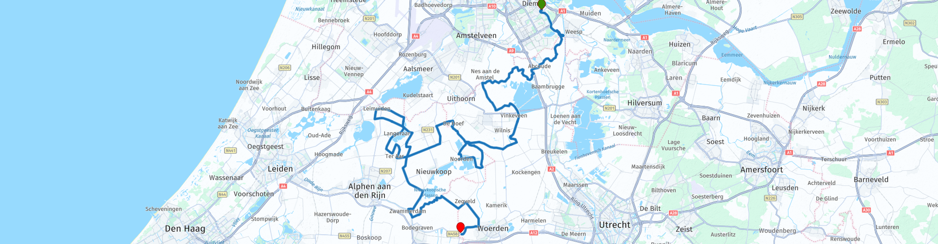
 * The Vinkeveense Plassen is a nature and water sports area in the northwest of the Dutch province of Utrecht, northeast of the village of Vinkeveen. (Source: Wikipedia)
** The Nieuwkoopse Plassen is a nature reserve of 1400 ha in South Holland near the towns of Nieuwkoop, Noorden and De Meije. Of this more than 1000 ha is owned by the Vereniging Natuurmonumenten. The ponds have been created from the 16th century by pealing the area. (Source: Wikipedia).
After lunch you go towards the "Kromme Mijdrecht" *** and you keep following this until just after De Hoef.
*** The Kromme Mijdrecht is a meandering river that runs from the Grecht in Woerdense Verlaat, via De Hoef, to the Amstel near Amstelhoek. It has a length of just over ten kilometers. On this river is a village in the municipality De Ronde Venen named after the river: Kromme Mijdrecht. (Source: Wikipedia)
Then you go in a sort of eight around the Langeraarse Plassen and tap Leimuiden briefly. You then drive back to the Nieuwkoopse Plassen to drive via Zwammerdam and Woerden to the terminus in Nieuwerbrug.
Because I have not driven this route (yet) myself, this route gets 3 stars.
Route details:
rp 16 - Lunch opportunity at "De Klinker" in North (Nieuwkoopse Plassen).


 Links
Links  Usage
Usage Want to download this route?
You can download the route for free without MyRoute-app account. To do so, open the route and click 'save as'. Want to edit this route?
No problem, start by opening the route. Follow the tutorial and create your personal MyRoute-app account. After registration, your trial starts automatically.  Disclaimer
Use of this GPS route is at your own expense and risk. The route has been carefully composed and checked by a MyRoute-app accredited RouteXpert for use on TomTom, Garmin and MyRoute-app Navigation.
Changes may nevertheless have occurred due to changed circumstances, road diversions or seasonal closures. We therefore recommend checking each route before use.
Preferably use the route track in your navigation system. More information about the use of MyRoute-app can be found on the website under 'Community' or 'Academy'.