TTT 2000 02 Rondje Westewolde

This route was brought to you by:
RouteXpert Hans van de Ven (Mr.MRA)
Last edit: 18-04-2021
 Route Summary
 The 173 ANWB Promoter TankTasTochten (TTT) were scanned by Henry ten Dam and signed by Leon Stolk in Mapsource and later placed as a Track in a .gpx file. These have been made available with the approval of ANWB Promotor via the website of MrGPS so that everyone can enjoy it. The 1st TTT is from 1992, so the route may be slightly different from the original.
I checked all route points and placed them neatly on the road. Also, if necessary, I have put the start point and end point of the route a bit further apart to avoid navigating directly to the end point and I have added the POI files from the start and end point just like a possible stopping point.
Finally, I created the route for TomTom, Garmin and MyRoute-app Navigation users.
With thanks to Henry, Leon, MrGPS and Promoter.
 Share this route


Animation

Verdict


Duration
3h 7m

Mode of travel
Car or motorcycle

Distance
127.13 km

Countries

 RouteXpert Review
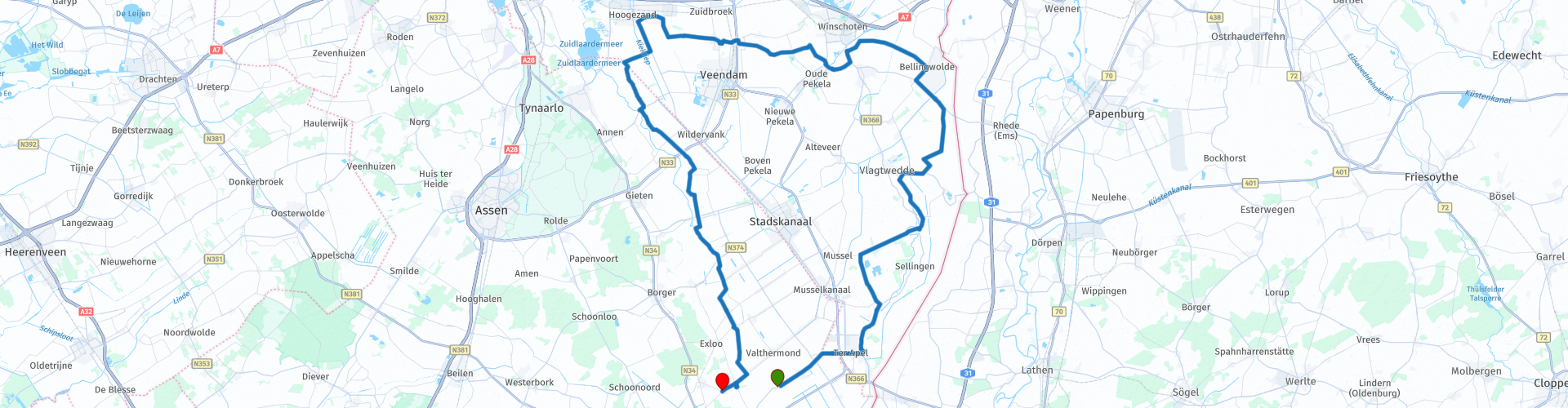
 Westerwolde is a Dutch municipality, formed on 1 January 2018. The municipality came from Bellingwedde and Vlagtwedde.
The municipality of Westerwolde has 21 villages: Agodorp *, Barnflair, Bellingwolde, Blijham, Bourtange, Jipsingboertange, Klein-Ulsda, Moorden *, Oudeschans, Over de Dijk, Rhederbrug, Sellingen, Ter Apel, Ter Apelkanaal, Veelerveen, Vlagtwedde, Vriescheloo, Wedde , Wedderheide, Wedderveer & Zandberg (partly).
Is the route going through all these villages?
* Agodorp is a neighborhood in Ter Apel in the municipality of Westerwolde in the province of Groningen. It was built in 1915 in the form of a garden village. The district is just south of Ter Apel and was built for the employees of AGO, Company for drying, finishing and processing wood. (Source: Wikipedia).
** Morige is a neighborhood in the Groningen municipality of Westerwolde. It lies just south of Blijham on the old road from Blijham to Wedde. Morige has more than 450 inhabitants. Morige lies on the sand ridge in the north of Westerwolde, which forms a horseshoe shape around the Westerwoldse Aa. (Source: Wikipedia).
Because I have not driven this route (yet) myself, this route gets 3 stars.
Route details:
There are lunch possibilities along the way, but bring something tasty and stopping on the way to lunch and enjoy the panoramic view is also an option.


 Usage
Usage Want to download this route?
You can download the route for free without MyRoute-app account. To do so, open the route and click 'save as'. Want to edit this route?
No problem, start by opening the route. Follow the tutorial and create your personal MyRoute-app account. After registration, your trial starts automatically.  Disclaimer
Use of this GPS route is at your own expense and risk. The route has been carefully composed and checked by a MyRoute-app accredited RouteXpert for use on TomTom, Garmin and MyRoute-app Navigation.
Changes may nevertheless have occurred due to changed circumstances, road diversions or seasonal closures. We therefore recommend checking each route before use.
Preferably use the route track in your navigation system. More information about the use of MyRoute-app can be found on the website under 'Community' or 'Academy'.