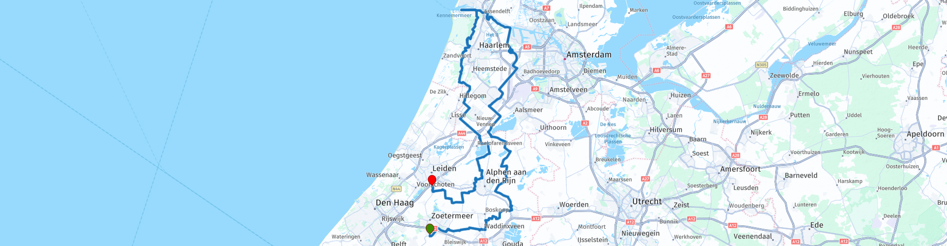
Tour Zoetermeer IJmuiden Zoeterwoude

This route was brought to you by:
RouteXpert Dick Schaap
Last edit: 05-01-2023
 Route Summary
 Start route: Lodge at the Lake, Scheglaan 12 2718 KZ Zoetermeer
End of route: La Place, Groene Hartplein 1, 2381 GS Zoeterwoude
I drove this route in 2022 and it is on well-maintained roads and dikes, with a rating of more than 4 stars.
 Share this route


Animation

Verdict


Duration
6h 39m

Mode of travel
Car or motorcycle

Distance
173.36 km

Countries

 RouteXpert Review
 Over the Hefbrug, the route turns left along the river Gouwe and then through the Boskoopse polders to the hamlet of Tempel. Temple is known for the beautiful cycling and walking routes in this area.
After Temple, the route continues through the Tempelpolder to Bodegraven. Bodegraven is a beautiful old town, once a border town on the Roman Limes. In Bodegraven the route passes 2 national monuments. First the mill Arkduif, a tower mill from 1697. Immediately afterwards there is a beautiful view of the old Water Tower from 1906, 34.15 m high with a water storage of 200 m3.
In Bodegraven, the Oude Rijn is crossed and followed to Zwammerdam. After Zwammerdam the route goes through polders and along the Nieuwkoopse, Langeraarsche and Westeinderplassen. In the ribbon village of Aarlanderveen, the route passes the Morgenster mill, a tower mill from 1870. A wooden octagon was used for the construction, which previously served as a blue mill in Utrecht.
In the Haarlemmermeerpolder, the route literally leaves Hoofddorp on the left and the N520 is followed in the direction of Lijnden, Zwanenburg and Halfweg. The N520 runs in the middle between the Schiphol runways, the Polderbaan and the Zwanenburgbaan. There is a phenomenal view of the take-off and landing of aircraft here with a beautiful underpass of the Avioduct in the N520.
Like many other lakes and ponds in the Netherlands, the Haarlemmermeer was also drained. In 1852, this lake turned into land. Schiphol is therefore actually located on the bottom of the former Haarlemmermeer, more than four meters below sea level.
In Halfweg the route passes a real “Bietenbrug”, the bridge over the Ringvaart that connects the towns of Halfweg and Zwanenburg. Sugar beets used to be transported over the (old) Bietenburg to the former sugar factory CSM (now Amsterdam Style Outlets, SugarCity).
“To go up the beet bridge” (also called to go up the beet mountain) means to go wrong, to end up wrong, to get into trouble. A beet bridge is a bridge over which farmers drove their carts with beets. Such a bridge became slippery because beets sometimes fell off the cart and were then flattened. Whoever wanted to go on such a bridge could slip. In a figurative sense, that could have become 'getting into trouble'.
Then straight ahead along the Houtrak park to the North Sea Canal. Along the North Sea Canal and partly through the recreation park Spaarnwoude it goes towards IJmuiden. In IJmuiden there is a nice stop at the "Kop van de Haven" The place where powerful drilling platforms are parked and where the largest seagoing vessels enter and leave. There is also a beautiful view of the fortress island of IJmuiden. Fort Island IJmuiden is a location with history in the mouth of the North Sea Canal. Part of the Defense Line of Amsterdam and UNESCO World Heritage. The position was built around 1889 to defend Amsterdam. With three floors, seventy-two classrooms and an underground system of corridors of five hundred and eighty-five meters, the fort is the largest of De Stelling van Amsterdam. Complete with domed hall, bunkers and murals.
On the route along the North Sea Canal there is a beautiful view of the lock complex IJmuiden. At IJmuiden, these form the connection between the North Sea Canal and the North Sea. The lock complex consists of the Zuidersluis from 1876, the Middensluis from 1896, the Noordersluis from 1929, the Spuisluis from 1940 and the pumping station from 1975. In January 2022, the Zeesluis IJmuiden will be operational. The Zeesluis IJmuiden is also called the "New front door of the Amsterdam port". Some facts about the new Sea Lock IJmuiden:
* 500 meters long, 70 meters wide and 18 meters deep.
* 630 million liters of water go into the lock. That is equivalent to 252 Olympic swimming pools.
* There is room for ships up to 399 meters long and 57 meters wide.
* The new sea lock is tide independent and can be used 24/7.
* Sea lock IJmuiden replaces the Noordersluis, which was completed in 1929.
After the northernmost point of the route, it goes south along beautiful nature reserves, the Kennemerland National Park and the Amsterdamse Waterleiding Duinen. Along the way past the Ruins of Brederode and over the infamous “Kopje van Bloemendaal” The road surface winds up here and is comparable to Belgian cobblestones. Be careful in wet weather! The “Kopje” has a turbulent history. It is an artificially constructed dune of up to 48m high (!) with a viewing tower on top. Used by the Germans as an observation post in WWII. Many cyclists find their Walhalla here. There is a tribute to Gerrie Knetemann because he is the uncrowned “King of the Cup”.
At the height of Bennebroek it goes back to the Haarlemmermeerpolder where the Ringvaart is followed over the Bennebroekerdijk to Beinsdorp. There the route enters the polder on straight polder roads to Oude Wetering. In Oude Wetering there is a crossing with the ferry service Oude Wetering - Leimuiden. This ferry service is located exactly on the edge of the Braassemermeer, which provides a beautiful view of the lake. The lake is rounded clockwise to the Woudwetering. There it goes along the Wetering to Alphen aan den Rijn.
In Alphen aan den Rijn, the Oude Rijn is followed for a short distance, after which Alphen is left in the direction of the Gemenewegse Polder. There the route meanders through the landscape of the Groene Hart in the direction of Zoeterwoude. Along the way there is a nice view of the "Rooie Wip", a characteristic wip mill from 1639. The name "Rooie Wip" is generally known and dates from 1918 when the mill also became a signal mill.


 Links
Links  Usage
Usage Want to download this route?
You can download the route for free without MyRoute-app account. To do so, open the route and click 'save as'. Want to edit this route?
No problem, start by opening the route. Follow the tutorial and create your personal MyRoute-app account. After registration, your trial starts automatically.  Disclaimer
Use of this GPS route is at your own expense and risk. The route has been carefully composed and checked by a MyRoute-app accredited RouteXpert for use on TomTom, Garmin and MyRoute-app Navigation.
Changes may nevertheless have occurred due to changed circumstances, road diversions or seasonal closures. We therefore recommend checking each route before use.
Preferably use the route track in your navigation system. More information about the use of MyRoute-app can be found on the website under 'Community' or 'Academy'.