Roundtrip Stecoah The Tail of the Dragon and Cherohala Skyway

This route was brought to you by:
RouteXpert René Plücken (MRA Master)
Last edit: 20-08-2025
 Route Summary
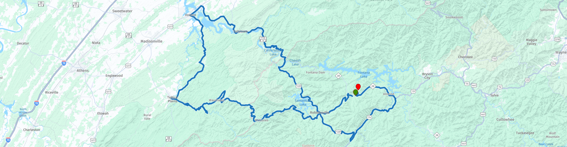
 A beautiful and favourite area among motorcyclists because of the beautiful winding roads, the beautiful nature and panoramas.
You will drive over the famous Tail of the Dragon, the Cherohala Skyway, along rivers, reservoirs and dams.
There are several stops planned along the way for food and drinks.
The start and end points are at Iron Horse Motorcycle Lodge and Resort.
I rate this route with 5 stars.
 Share this route


Animation

Verdict


Duration
9h 10m

Mode of travel
Car or motorcycle

Distance
288.79 km

Countries

 RouteXpert Review
 We turn the NC-143 towards Robbinsville on what is already a beautiful piece of driving with many curves. From Robbinsville we take the US-129 that runs for a large part along the Cheoah River and the Santeetlah lake. Many curves and now and then some bridges where you have a beautiful view of the river and the lake on the left and right.
We ride the legendary "Tail of the Dragon", but first take a picture at the big metal statue of the Dragon, score a souvenir or T-shirt in the souvenir shop and maybe have a drink and/or something to eat in the restaurant. Here is also the Deals Gap Motorcycle Resort, where the monument the "Tree of Shame" is located, to which we do not want to donate parts!!
"The Tail of the Dragon" or "Deals Gap" is a popular and internationally known destination for motorcycle and sports car enthusiasts, as the 11-mile (18 km) stretch in Tennessee is said to have 318 curves. Some of the sharpest curves have names such as Copperhead Corner, Hog Pen Bend, Wheelie Hell, Shade Tree Corner, Mud Corner, Sunset Corner, Gravity Cavity, Beginner's End and Brake or Bust Bend. The road earned its name because it resembles a dragon's tail.
There are several parking areas along the route where you can stop briefly to enjoy the view and take some pictures. If you have the time I would turn around at the end point and ride “The Dragon” in the other direction which is a whole other dimension.
Stop in the town of Vonore for a bite to eat and a drink at Hardees. After this short break we drive to Tellico Plains, where you can visit the Cherohala Skyway Visitor Centre, if you are still hungry you can eat something here at one of the local restaurants that serve everything from Southern barbecue, sandwiches to pizzas made in wood-fired pizza ovens and traditional American dishes.
In Tellico Plains begins the Cherohala Skyway, which is definitely one of the most scenic routes in the Blue Ridge Mountains in North Carolina. We stop briefly at the Telliquah Bridge, this is one of the most beautiful and recognizable attractions of Tellico Plains. Hundreds of tourists stop here every year to photograph the bridge. It is perhaps even the most photographed bridge in the state of Tennessee.
We briefly leave the Cherohala Skyway to visit the nearly 100-foot-high "Bald River Falls," considered one of the most spectacular waterfalls in the region.
In Robbinsville you can stop at Lynn's Place for a break and a drink, a popular stop among motorcyclists.
This route with many beautiful views in the mountains is truly breathtaking. Stop at one of the many small parking areas (overlooks) to enjoy or to walk a bit and have a picnic.
The “Dragon” and Cherohala Skyway are rightly favorite routes for motorcyclists and sports car drivers because of the many twists and turns and the beautiful scenery. Take your time and stop often along the way to enjoy the beautiful surroundings.


 Links
Links  Usage
Usage Want to download this route?
You can download the route for free without MyRoute-app account. To do so, open the route and click 'save as'. Want to edit this route?
No problem, start by opening the route. Follow the tutorial and create your personal MyRoute-app account. After registration, your trial starts automatically.  Disclaimer
Use of this GPS route is at your own expense and risk. The route has been carefully composed and checked by a MyRoute-app accredited RouteXpert for use on TomTom, Garmin and MyRoute-app Navigation.
Changes may nevertheless have occurred due to changed circumstances, road diversions or seasonal closures. We therefore recommend checking each route before use.
Preferably use the route track in your navigation system. More information about the use of MyRoute-app can be found on the website under 'Community' or 'Academy'.

North Carolina
About this region
North Carolina is a state in the Southeastern region of the United States. North Carolina is the 28th largest and 9th-most populous of the 50 United States. It is bordered by Virginia to the north, the Atlantic Ocean to the east, Georgia and South Carolina to the south, and Tennessee to the west. Raleigh is the state's capital and Charlotte is its largest city. The Charlotte metropolitan area, with an estimated population of 2,569,213 in 2018, is the most-populous metropolitan area in North Carolina, the 23rd-most populous in the United States, and the largest banking center in the nation after New York City. The Raleigh-Durham-Cary combined statistical area is the second-largest metropolitan area in the state, with an estimated population of 2,079,687 in 2019, and is home to the largest research park in the United States, Research Triangle Park.
Earliest discoveries of human occupation in North Carolina date back to 10,000 years ago, found at the Hardaway Site. North Carolina was inhabited by Carolina Algonquian, Iroquoian, and Siouan speaking tribes of Native Americans prior to the arrival of Europeans. North Carolina was established as a royal colony in 1729 and was one of the Thirteen Colonies. North Carolina is named in honor of King Charles I of England who first formed the English colony, Carolus being Latin for "Charles". The Halifax Resolves resolution adopted by North Carolina on April 12, 1776, was the first formal call for independence from Great Britain among the American Colonies during the American Revolution.On November 21, 1789, North Carolina became the 12th state to ratify the United States constitution. In the run-up to the American Civil War, North Carolina declared its secession from the Union on May 20, 1861, becoming the tenth of eleven states to join the Confederate States of America. Following the Civil War, the state was restored to the Union on July 4, 1868. On December 17, 1903, Orville and Wilbur Wright successfully piloted the world's first controlled, sustained flight of a powered, heavier-than-air aircraft at Kitty Hawk in North Carolina's Outer Banks. North Carolina uses the slogan "First in Flight" on state license plates to commemorate this achievement, alongside a newer alternative design bearing the slogan "First in Freedom" in reference to the Mecklenburg Declaration and Halifax Resolves.
North Carolina is defined by a wide range of elevations and landscapes. From west to east, North Carolina's elevation descends from the Appalachian Mountains to the Piedmont and Atlantic coastal plain. North Carolina's Mount Mitchell at 6,684 feet (2,037 m) is the highest point in North America east of the Mississippi River. Most of the state falls in the humid subtropical climate zone; however, the western, mountainous part of the state has a subtropical highland climate.
Read more on Wikipedia
Earliest discoveries of human occupation in North Carolina date back to 10,000 years ago, found at the Hardaway Site. North Carolina was inhabited by Carolina Algonquian, Iroquoian, and Siouan speaking tribes of Native Americans prior to the arrival of Europeans. North Carolina was established as a royal colony in 1729 and was one of the Thirteen Colonies. North Carolina is named in honor of King Charles I of England who first formed the English colony, Carolus being Latin for "Charles". The Halifax Resolves resolution adopted by North Carolina on April 12, 1776, was the first formal call for independence from Great Britain among the American Colonies during the American Revolution.On November 21, 1789, North Carolina became the 12th state to ratify the United States constitution. In the run-up to the American Civil War, North Carolina declared its secession from the Union on May 20, 1861, becoming the tenth of eleven states to join the Confederate States of America. Following the Civil War, the state was restored to the Union on July 4, 1868. On December 17, 1903, Orville and Wilbur Wright successfully piloted the world's first controlled, sustained flight of a powered, heavier-than-air aircraft at Kitty Hawk in North Carolina's Outer Banks. North Carolina uses the slogan "First in Flight" on state license plates to commemorate this achievement, alongside a newer alternative design bearing the slogan "First in Freedom" in reference to the Mecklenburg Declaration and Halifax Resolves.
North Carolina is defined by a wide range of elevations and landscapes. From west to east, North Carolina's elevation descends from the Appalachian Mountains to the Piedmont and Atlantic coastal plain. North Carolina's Mount Mitchell at 6,684 feet (2,037 m) is the highest point in North America east of the Mississippi River. Most of the state falls in the humid subtropical climate zone; however, the western, mountainous part of the state has a subtropical highland climate.
View region
 Statistics
  27
27Amount of RX reviews (North Carolina)
 24822
24822Amount of visitors (North Carolina)
 711
711Amount of downloads (North Carolina)
 Route Collections in this region
 The Original Southern Dozen Motorcycle Rides in Tennessee Virginia and North Carolina
The Southern Dozen; hit the throttle and hold on tight!
There’s no better place to leave the daily grind in the dust than roaring around the curves of the Southern Dozen! Surrounded by some of the most breathtaking natural beauty in the country, you’ll find the freedom of exhilaration as you wind through the foothills and mountains of Northeast Tennessee, Southwest Virginia, and Western North Carolina.
Whether you’re looking for heart-pumping curves, breathtaking scenery, historic landmarks, local gems, or nearby attractions, the Southern Dozen has rides worthy of even the most seasoned road warrior. Explore the Original Southern Dozen and see all that Johnson City and the surrounding region have to offer.
Johnson City is a regional gem where big-city amenities meet small-town Southern charm. Here you’ll have access to everything you could want or need and more! Perfect for the casual rider and those who “live to ride,” Johnson City hosts numerous bike rallies each year. So plan your trip and book one of the many biker-friendly accommodations.
View Route Collection
The 10 most downloaded routes in the USA from RouteXpert Hans van de Ven
Hello and welcome to this collection of the Top 10 MyRoute app downloaded routes in USA.
There will be a great new event to be announced soon, where all these routes can be driven.
Download them all now and place them in a new "Top 10" folder, so that you always have them at hand.
If you are going to drive one of these routes in the meantime, track them with the MRA Mobile App or with MRA Navigation. Take some photos (moments) along the way as these will come in handy.
Create a travelogue of your Top 10 driven routes and add the recorded track to it.
There will also be some great prizes on offer, so keep an eye on the MRA-RouteXperts page and your mail.
The 10 routes are:
1. D13 Estes Park Denver
2. D03 Chadron Custer
3. D01 Pigeon Forge round trip through the Smokey Mountains
4. D08 Kalispell Sandpoint
5. D10 Colville Wenatchee
6. D09 Sandpoint Colville
7. D04 Custer Wall
8. D11 Wenatchee Seattle
9. D08 Cody Yellowstone NP
10.R13 San Francisco Monterey
View Route Collection