Day 2 Chattanooga to Stecoah

This route was brought to you by:
RouteXpert René Plücken (MRA Master)
Last edit: 12-02-2021
 Route Summary
 America is pre-eminently a country to explore on a motorcycle. There are many travel organizations that offer organized tours, but the charm is also to map out routes and drive on your own.
Good motorbike rental companies can be found throughout the country and the bikes are often of the latest model and well maintained.
We drive on the beautiful roads in the states of Nashville and North Carolina and this area is characterized by the beautiful idyllic landscape with provincial two-lane roads that wind through the landscape with many curves, you can visit beautiful towns, villages and places of interest.
Be careful though, because the roads are sometimes of very poor quality and hardly or not lit up in the dark.
For each route there is a more detailed description in the review.
The route is suitable for TomTom, Garmin, Harley-Davidson BoomBox 2 (2019 model) and MyRoute-app Navigation.
 Share this route


Animation

Verdict


Duration
4h 26m

Mode of travel
Car or motorcycle

Distance
272.48 km

Countries

 RouteXpert Review
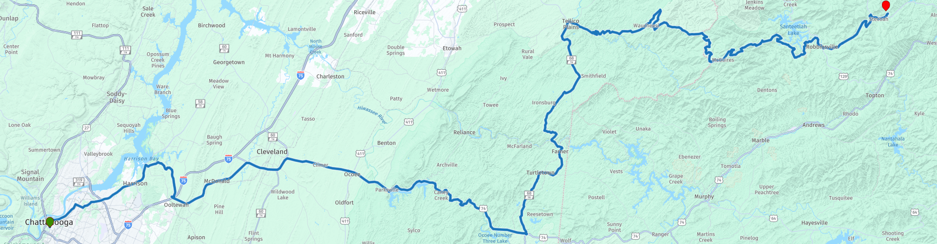
 We drive through the woods via US Highway 64 (S. Lee Highway) via Cleveland to the Cherokee National Forrest. This road already has a multitude of wonderful curves and leads us along the river and the lake of the same name Ocoee. At the village of Ducktown we leave the Highway and take the TN-68 north through the beautiful rolling and green landscape of Tennessee.
After we have crossed the Hiwassee river at RP11, the better cornering starts. After 30 kilometers we turn right at Tellico Pains onto the Cherohala Skyway, this road is a 69 kilometer long National Scenic Byway that connects Tellico Plains Tennessee with Robbinsville North Carolina. The name of this Skyway is a combination of Cherokee and Nantahala, the two national forests through which it goes.
At RP13 is a Cherohala Skyway visitors center where we can purchase a souvenir or gather some extra information about the area.
At RP14 we see the beautiful covered Telliquah bridge built by Tom Cormier to honor the past.
At RP15 is one of the Smoky Mountains Harley-Davidson Dealership and here we can stop for a T-Shirt or other souvenir or just enjoy the motorbikes. On the other side we can have lunch at Iron Works Grille.
At RP18 we leave the state of Tennessee and enter North Carolina and continue to the end of this beautiful winding Cherohala Skyway in Robbinsville (RP20), where we also refuel for the next day.
From here it is 20 kilometers to the end of this route at Iron Horse Motorcycle Lodge and Resort, where we stay for three days to enjoy the beautiful roads in this area.
This route is worth 4 **** stars because of the beautiful roads and beautiful panoramas in the 2nd part of the ride.


 Links
Links  Usage
Usage Want to download this route?
You can download the route for free without MyRoute-app account. To do so, open the route and click 'save as'. Want to edit this route?
No problem, start by opening the route. Follow the tutorial and create your personal MyRoute-app account. After registration, your trial starts automatically.  Disclaimer
Use of this GPS route is at your own expense and risk. The route has been carefully composed and checked by a MyRoute-app accredited RouteXpert for use on TomTom, Garmin and MyRoute-app Navigation.
Changes may nevertheless have occurred due to changed circumstances, road diversions or seasonal closures. We therefore recommend checking each route before use.
Preferably use the route track in your navigation system. More information about the use of MyRoute-app can be found on the website under 'Community' or 'Academy'.

North Carolina
About this region
North Carolina is a state in the Southeastern region of the United States. North Carolina is the 28th largest and 9th-most populous of the 50 United States. It is bordered by Virginia to the north, the Atlantic Ocean to the east, Georgia and South Carolina to the south, and Tennessee to the west. Raleigh is the state's capital and Charlotte is its largest city. The Charlotte metropolitan area, with an estimated population of 2,569,213 in 2018, is the most-populous metropolitan area in North Carolina, the 23rd-most populous in the United States, and the largest banking center in the nation after New York City. The Raleigh-Durham-Cary combined statistical area is the second-largest metropolitan area in the state, with an estimated population of 2,079,687 in 2019, and is home to the largest research park in the United States, Research Triangle Park.
Earliest discoveries of human occupation in North Carolina date back to 10,000 years ago, found at the Hardaway Site. North Carolina was inhabited by Carolina Algonquian, Iroquoian, and Siouan speaking tribes of Native Americans prior to the arrival of Europeans. North Carolina was established as a royal colony in 1729 and was one of the Thirteen Colonies. North Carolina is named in honor of King Charles I of England who first formed the English colony, Carolus being Latin for "Charles". The Halifax Resolves resolution adopted by North Carolina on April 12, 1776, was the first formal call for independence from Great Britain among the American Colonies during the American Revolution.On November 21, 1789, North Carolina became the 12th state to ratify the United States constitution. In the run-up to the American Civil War, North Carolina declared its secession from the Union on May 20, 1861, becoming the tenth of eleven states to join the Confederate States of America. Following the Civil War, the state was restored to the Union on July 4, 1868. On December 17, 1903, Orville and Wilbur Wright successfully piloted the world's first controlled, sustained flight of a powered, heavier-than-air aircraft at Kitty Hawk in North Carolina's Outer Banks. North Carolina uses the slogan "First in Flight" on state license plates to commemorate this achievement, alongside a newer alternative design bearing the slogan "First in Freedom" in reference to the Mecklenburg Declaration and Halifax Resolves.
North Carolina is defined by a wide range of elevations and landscapes. From west to east, North Carolina's elevation descends from the Appalachian Mountains to the Piedmont and Atlantic coastal plain. North Carolina's Mount Mitchell at 6,684 feet (2,037 m) is the highest point in North America east of the Mississippi River. Most of the state falls in the humid subtropical climate zone; however, the western, mountainous part of the state has a subtropical highland climate.
Read more on Wikipedia
Earliest discoveries of human occupation in North Carolina date back to 10,000 years ago, found at the Hardaway Site. North Carolina was inhabited by Carolina Algonquian, Iroquoian, and Siouan speaking tribes of Native Americans prior to the arrival of Europeans. North Carolina was established as a royal colony in 1729 and was one of the Thirteen Colonies. North Carolina is named in honor of King Charles I of England who first formed the English colony, Carolus being Latin for "Charles". The Halifax Resolves resolution adopted by North Carolina on April 12, 1776, was the first formal call for independence from Great Britain among the American Colonies during the American Revolution.On November 21, 1789, North Carolina became the 12th state to ratify the United States constitution. In the run-up to the American Civil War, North Carolina declared its secession from the Union on May 20, 1861, becoming the tenth of eleven states to join the Confederate States of America. Following the Civil War, the state was restored to the Union on July 4, 1868. On December 17, 1903, Orville and Wilbur Wright successfully piloted the world's first controlled, sustained flight of a powered, heavier-than-air aircraft at Kitty Hawk in North Carolina's Outer Banks. North Carolina uses the slogan "First in Flight" on state license plates to commemorate this achievement, alongside a newer alternative design bearing the slogan "First in Freedom" in reference to the Mecklenburg Declaration and Halifax Resolves.
North Carolina is defined by a wide range of elevations and landscapes. From west to east, North Carolina's elevation descends from the Appalachian Mountains to the Piedmont and Atlantic coastal plain. North Carolina's Mount Mitchell at 6,684 feet (2,037 m) is the highest point in North America east of the Mississippi River. Most of the state falls in the humid subtropical climate zone; however, the western, mountainous part of the state has a subtropical highland climate.
View region
 Statistics
  25
25Amount of RX reviews (North Carolina)
 16756
16756Amount of visitors (North Carolina)
 628
628Amount of downloads (North Carolina)
 Route Collections in this region
 The Original Southern Dozen Motorcycle Rides in Tennessee Virginia and North Carolina
The Southern Dozen; hit the throttle and hold on tight!
There’s no better place to leave the daily grind in the dust than roaring around the curves of the Southern Dozen! Surrounded by some of the most breathtaking natural beauty in the country, you’ll find the freedom of exhilaration as you wind through the foothills and mountains of Northeast Tennessee, Southwest Virginia, and Western North Carolina.
Whether you’re looking for heart-pumping curves, breathtaking scenery, historic landmarks, local gems, or nearby attractions, the Southern Dozen has rides worthy of even the most seasoned road warrior. Explore the Original Southern Dozen and see all that Johnson City and the surrounding region have to offer.
Johnson City is a regional gem where big-city amenities meet small-town Southern charm. Here you’ll have access to everything you could want or need and more! Perfect for the casual rider and those who “live to ride,” Johnson City hosts numerous bike rallies each year. So plan your trip and book one of the many biker-friendly accommodations.
View Route Collection
The 10 most downloaded routes in the USA from RouteXpert Hans van de Ven
Hello and welcome to this collection of the Top 10 MyRoute app downloaded routes in USA.
There will be a great new event to be announced soon, where all these routes can be driven.
Download them all now and place them in a new "Top 10" folder, so that you always have them at hand.
If you are going to drive one of these routes in the meantime, track them with the MRA Mobile App or with MRA Navigation. Take some photos (moments) along the way as these will come in handy.
Create a travelogue of your Top 10 driven routes and add the recorded track to it.
There will also be some great prizes on offer, so keep an eye on the MRA-RouteXperts page and your mail.
The 10 routes are:
1. D13 Estes Park Denver
2. D03 Chadron Custer
3. D01 Pigeon Forge round trip through the Smokey Mountains
4. D08 Kalispell Sandpoint
5. D10 Colville Wenatchee
6. D09 Sandpoint Colville
7. D04 Custer Wall
8. D11 Wenatchee Seattle
9. D08 Cody Yellowstone NP
10.R13 San Francisco Monterey
View Route Collection