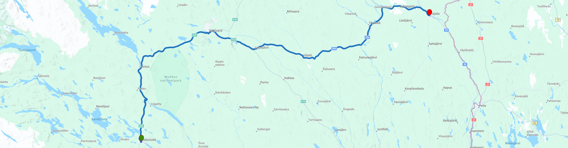
R14 Jokkmokk to Pajala

This route was brought to you by:
RouteXpert Arno van Lochem - Senior RX
Last edit: 06-07-2021
 Route Summary
 De routes zijn voor een ieder goed te rijden en gaan over goed geasfalteerde wegen. Er zal wellicht een enkele haarspeldbocht genomen moeten worden, maar die zijn prima te doen.
Mocht er een stuk gravel in de route voorkomen, dan wordt daarvoor gewaarschuwd en is er een omleiding aangegeven.
De route loopt van Jokkmokk naar Pajala, dat tegen de Finse grens aan ligt. De route loopt wederom door uitgestrekt gebied, waarin naaldbomen, bergberkenbomen en meren zorgen voor je uitzicht. Onderweg wel wat leuke bezienswaardigheden, zoals het Harsprångsfallet Utsiktsplats en de Porjus gamla kraftstation.
Het uitgestrekte landschap is de reden dat je beter kunt zorgen dat je wat te eten en te drinken bij je hebt voor onderweg, aangezien de horeca-gelegenheden in dit gebied niet bepaald in ruime getalen aanwezig zijn.
De deelnemers van de Arctic Challenge kregen bij terugkomt van hun rit over de Lofoten de volgende ochtend het coördinaat van hun volgende bestemming. Dat bleek zo'n 625 kilometer verderop te liggen, in de plaats Gällivare (Zweden) bij een tankstation. De route loopt langs dit punt.
Uitgestrekt landschap en mooie uitzichten, mooie wegen en leuke bezienswaardigheden, vandaar de waardering van 4 sterren.
 Share this route


Animation

Verdict


Duration
6h 5m

Mode of travel
Car or motorcycle

Distance
239.43 km

Countries

 RouteXpert Review
 Of all western European countries, the Scandinavian countries probably have the most more or less untouched nature. In addition, they are countries that are easily accessible from the Netherlands. Norway is characterized by, among other things, the fjords and the Trollstigen, known to many motorcyclists. And where Sweden is known as wide and relaxing, everyone knows Finland as the land of 1000 lakes. All in all, legitimate reasons to traverse this beautiful nature in the north of Europe by means of a number of routes.
The route starts in Jokkmokk, a town just inside the Arctic Circle. The first 50 kilometers you drive north, then mainly east. You drive through a mountainous area, given the height differences now and then. In some places, grateful use is made of these height differences, in combination with snow, which is also abundantly present here in winter. There are several winter sports areas in this area.
Once you have passed just about the only hairpin bend on this route, you will cross the Lule, a river in the north of Norrland. This river is 461 kilometers long and has a catchment area of 25240 km².
The river offers two sights, of which you should definitely check out the first. It concerns the Harsprångsfallet Utsiktsplats, or a natural groove. This is said to be one of the most powerful rapids in Sweden, perhaps larger than Storforsen in the river Pite. The river plunges 75 meters through a narrow gorge for a distance of 4.2 kilometers. The name Harsprånget came from the quick twists in the groove that can be compared to that of a hare in flight. The average water flow in the river in Harsprånget was about 268 m³ / s. By way of comparison: the river Pite at Storforsen has an average water flow rate of 120 m³ / s.
It's a short walk from the car park, but well worth it, beautiful piece of nature.
A little further you will find the second attraction, the Porjus gamla kraft station, roughly translated the old power station of Porjus. Porjus was Vattenfall's first major power plant in Stora Luleälv, at the outlet of Stora Lulevatten in the town of Porjus in the municipality of Jokkmokk. The first power plant was built in 1910–1915. Today it houses a museum and hydropower equipment for education and research. Electricity is produced in the new power plant, which was built in 1971–1982 a few hundred meters northwest of the old power plant. Today it is the third largest in Vattenfall (and Sweden) with a normal annual production of 1233 GWh.
The construction of the hydroelectric power plant in Porjus was the result of an offensive government policy, an investment in industrial development that would benefit the whole nation. Porjus was mainly added to electrify the Riksgränsbanan, on which the ore from Kiruna was transported to the port of Narvik. But the investment also included a vision of what the power plant could mean for the industrialization of Norrbotten.
The old power plant is now a museum and houses a training unit and a research unit. During the summer months the museum is open for unannounced visits, when you can also get a free guided tour of the entire station. During other parts of the year it is possible to book guided tours. Of particular interest is the engine room, which sums up 90 years of Swedish power plant history; the first units were built in the 1910s and the newest, U8 and U9, in the late 1990s.
The old power station also has a suspension bridge, which has been hanging over the Luleälv River for nearly 100 years. Nice to have a look and of course to capture it in the photo.
In Gällivare it is high time for the first coffee break. After a short sightseeing through this town you will arrive at the coffee stop in Nyfiket, where they can also serve a nice sandwich in addition to coffee.
As mentioned, the participants of the Arctic Challenge 2020 in Bodø received the first coordinate for the continuation of their challenge. That coordinate is in this town, at a gas station where you pass after the coffee stop. It's the gas station at the second roundabout. At this gas station they received the coordinate of the next target: Sirkka, a winter sports resort in Finnish Lapland.
Although the number of attractions in this route is limited to the first part, it is still a route where you can enjoy the view, the landscape and the great lakes you pass. But mainly use the parking places to stop and enjoy all that beauty for a moment.
In Ulatti there is an opportunity at a gas station to buy a cup of coffee. Funny to see that there are a few houses along a street and that there is still a gas station. Sometimes you don't understand how they can exist.
The next stop is planned in Tärendö, again a small town. First you can fill the tank here, then lunch is planned at the Arctic River Lodge. An old school building, renovated in tasteful Scandinavian style, located more than 100 kilometers north of the Arctic Circle.
After lunch you still have 40 kilometers to go, then you arrive in the town of Pajala, the final destination of this route. A little more specific: The Lapland River Hotel. This hotel has a bar and a restaurant, so here too you can relive the route while enjoying a beer.
A phenomenon that you can easily observe this north in Sweden is the midnight sun. In Jokkmokk, where this route started, the midnight sun can be seen for 32 days in a row. In the town where the route ends, it will be somewhere between 35 and 40 days.
The midnight sun never completely disappears; however the sun sinks quite low and floats just above the horizon. The sun now hangs for several hours between sunset and sunrise, emitting a soft glow: a dream come true for every photographer. Shady silhouettes against a golden sky with the mighty Swedish nature all around you, that is an experience that many people would love to experience.
In the north of Sweden, the midnight sun shines from the end of May to mid-July. However, a warning is in order, exposure to this phenomenon can disrupt your sleep cycle.
A campsite is signposted for the camper near the end point: Pajala Camping.
Have fun driving this route!


 Links
Links  Usage
Usage Want to download this route?
You can download the route for free without MyRoute-app account. To do so, open the route and click 'save as'. Want to edit this route?
No problem, start by opening the route. Follow the tutorial and create your personal MyRoute-app account. After registration, your trial starts automatically.  Disclaimer
Use of this GPS route is at your own expense and risk. The route has been carefully composed and checked by a MyRoute-app accredited RouteXpert for use on TomTom, Garmin and MyRoute-app Navigation.
Changes may nevertheless have occurred due to changed circumstances, road diversions or seasonal closures. We therefore recommend checking each route before use.
Preferably use the route track in your navigation system. More information about the use of MyRoute-app can be found on the website under 'Community' or 'Academy'.