03 Konya to Urgup via Ihlara Valley Capadocia

This route was brought to you by:
RouteXpert Yannis Papadiotis (wheelboy)
Last edit: 07-11-2025
 Route Summary
 Turkey isn’t just a country, it’s a rider’s playground.
This is the 3rd of the 12 stage journey which takes you from Aegean coastlines through mountains, plains, and fairytale valleys all the way to the Black Sea and back west again.
Each leg has its own flavor, so here’s a deeper look.
Route 3:
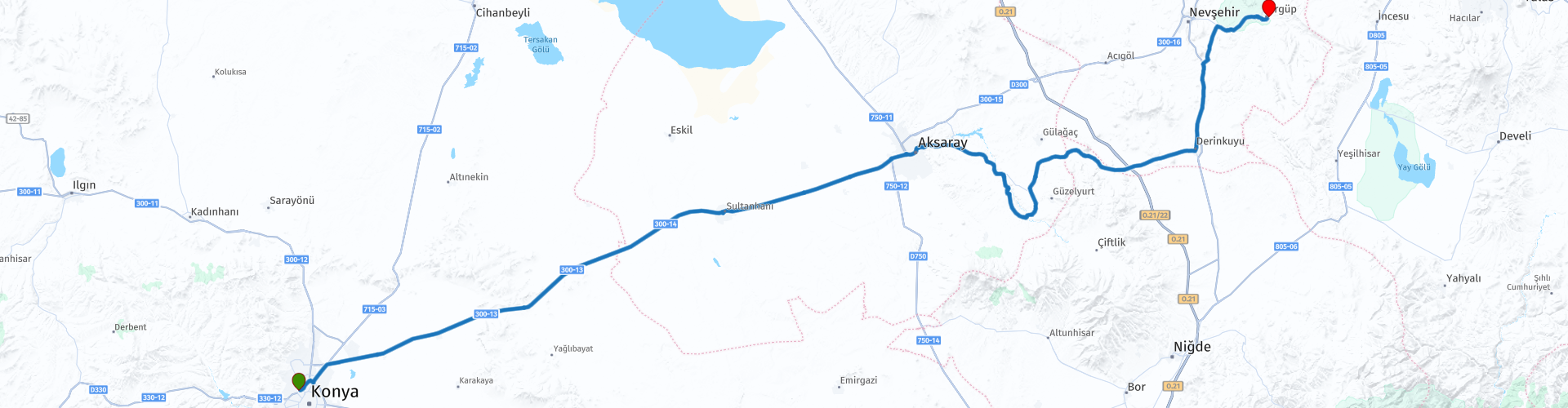
The journey from Konya and its mosques leads to Urgup across Anatolia’s vast plains and into the surreal heart of Cappadocia. Smooth highways guide you past Sultanhanı Caravanserai and the volcanic canyon of Ihlara Valley before descending into the underground cities of Derinkuyu and Kaymaklı. As you near Urgup, the landscape transforms into a world of fairy chimneys, cave dwellings, and glowing rock valleys. It’s an easy, flowing ride that trades sharp turns for spectacular scenery, a route that blends history, culture, and geology into one unforgettable passage across Turkey’s most magical region.
My vote for this route is 5*, not for its challenge but for its transformation from the quiet heart of Anatolia to the dreamlike world of Cappadocia, where every kilometer feels like a slow reveal of something extraordinary.
 Share this route


Animation

Verdict


Duration
7h 16m

Mode of travel
Car or motorcycle

Distance
283.66 km

Countries

 RouteXpert Review
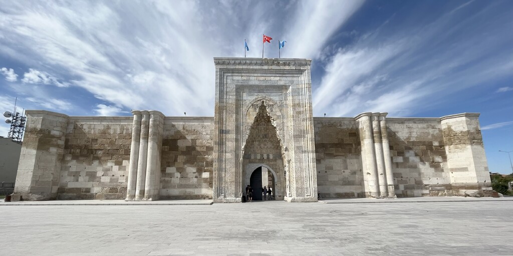
 From there, the ride continues through Aksaray, a mid-sized city that breaks up the monotony of the plains. Beyond Aksaray, the scenery begins to shift. The horizon ripples into gentle hills, signaling your approach to Ihlara Valley, one of central Turkey’s hidden treasures. Just before reaching it, the Selime rock formations come into view, a dramatic cluster of towering tufa spires and honeycombed cliffs carved by wind and time. Even without stopping, the panorama is breathtaking, a natural preview of what Cappadocia holds ahead.
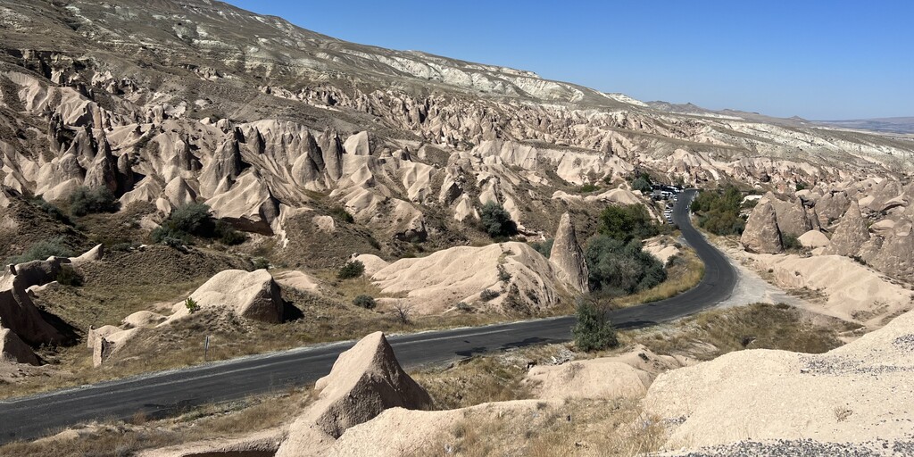
Descending into Ihlara Valley, the air cools and the colors change. This narrow gorge carved by the Melendiz River is lush and green, a welcome contrast to the arid plateau above. It’s an ideal spot to pause for a coffee or light lunch while listening to the river and the distant call of birds echoing through the canyon walls.
After leaving Ihlara, the route offers a scenic extension worth taking if time allows the Sofular Valley detour. Located in the Gülağaç district of Aksaray, Sofular is a protected natural area filled with rock cut dwellings, cave churches, tunnels, and even an unexplored underground city. It’s linked geologically to the obsidian rich Nenezi Dağı, and the terrain here feels quieter and more primal than the better known valleys of Cappadocia. From Sofular, a short unpaved but easy 4 km road leads to Narlıgöl Crater Lake, a turquoise geothermal lake formed inside a volcanic crater. The color and stillness of the water make it a perfect photo stop and a short but rewarding scenic deviation before returning to the main road.
Continuing north, a brief refueling stop is recommended before reaching Derinkuyu, a modest town with a small church and an antique shop that make a quick, authentic stop. From here, you continue to Kaymaklı Underground City, a vast labyrinth carved deep into volcanic rock, with narrow tunnels, stone doors, and air shafts that speak of ancient ingenuity and survival.
The final leg brings you closer to Ürgüp, and the scenery becomes more dramatic with every kilometer. Rolling hills give way to Cappadocia’s signature landscape, soft volcanic rock shaped into surreal cones and spires. Just before reaching town, stop briefly at the famous “Three Beauties” viewpoint, where three fairy chimneys stand side by side, perfectly capturing the spirit of the region. A few last photos here and the day’s ride ends in Ürgüp, where cave hotels, stone houses, and gentle evening light mark your arrival in one of Turkey’s most extraordinary settings.
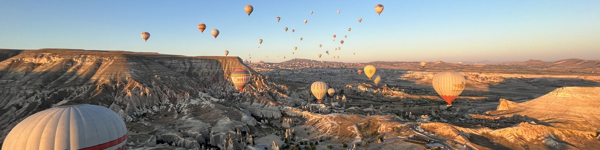
If there’s one part of the trip where you must allow an extra day, it’s here in Cappadocia. The region is world famous for its hot air balloon flights, which launch at dawn over the fairy chimneys, valleys, and ancient cave dwellings. Watching the balloons rise with the sunrise or better yet, being in one is an unforgettable experience that captures the magic of this landscape. Balloon flights typically last about an hour and provide panoramic views of Göreme, Love Valley, and Uçhisar Castle. The area also offers ATV rides, horse trekking, and sunset viewpoints if you prefer to keep your wheels on the ground. Take your time here Cappadocia deserves a full day of exploration beyond the saddle.
 Links
Links  Usage
Usage Want to download this route?
You can download the route for free without MyRoute-app account. To do so, open the route and click 'save as'. Want to edit this route?
No problem, start by opening the route. Follow the tutorial and create your personal MyRoute-app account. After registration, your trial starts automatically.  Disclaimer
Use of this GPS route is at your own expense and risk. The route has been carefully composed and checked by a MyRoute-app accredited RouteXpert for use on TomTom, Garmin and MyRoute-app Navigation.
Changes may nevertheless have occurred due to changed circumstances, road diversions or seasonal closures. We therefore recommend checking each route before use.
Preferably use the route track in your navigation system. More information about the use of MyRoute-app can be found on the website under 'Community' or 'Academy'.

Aksaray
About this region
Aksaray (pronounced [ˈaksaɾaj], Koine Greek: Ἀρχελαΐς, Medieval Greek: Κολώνεια, Ancient Greek: Γαρσάουρα) is a city in the Central Anatolia region of Turkey and the capital district of Aksaray Province. With an estimated 2020 population of 423,011 distributed over about 7,659 km2 (2,957 sq mi). The average elevation is 980 m (3,215 ft), with the highest point being Mt. Hasan at 3,253 m (10,673 ft).
Read more on Wikipedia
View region
 Statistics
  1
1Amount of RX reviews (Aksaray)
 173
173Amount of visitors (Aksaray)
 1
1Amount of downloads (Aksaray)
 Route Collections in this region
 Riding Across Turkey Route by Route
This route collection offers a complete journey across Turkey, combining iconic landmarks with diverse landscapes.
Starting from the Aegean coast, you explore Ephesus and Pamukkale before heading inland to Lake Salda and Sagalassos. Cappadocia forms a highlight with its unique rock formations and underground cities. The route then crosses central Anatolia’s wide plains toward the rugged east, where quieter roads and dramatic scenery dominate. A major contrast follows along the Black Sea, with green mountains and coastal views. The return west through Bursa and Pergamon adds rich history.
Overall, this is a well balanced itinerary ideal for travelers seeking variety, culture, and scenic driving.
View Route Collection